The management of contaminated and rehabilitated sites is a critical component of contemporary environmental governance, particularly in regions characterised by intensive industrial, logistics, and urban development. In this context, the present study adopts a qualitative, exploratory, and comparative approach to analyse the structure and implementation of Contaminated and Rehabilitated Area Inventories (CRAI) worldwide and situates these experiences within the Brazilian context. First, an international comparative overview was conducted, examining consolidated registries in countries in different continents to identify global best practices and gaps in standardisation. This assessment is subsequently contextualised within the Brazilian framework, evaluating disparities and recent advancements among key state-level systems, with particular emphasis on the Rio de Janeiro State (RJ) as a representative case study. International experiences reveal significant variation in institutional arrangements, regulatory frameworks, and technological maturity. Despite this diversity, global trends point toward greater transparency, geospatial integration, and the use of standardised classification systems for managing contaminated sites. In recent years, Rio de Janeiro has made significant progress by institutionalising its CRAI, integrating it into the State Environmental Information System, and strengthening state-municipal coordination. As a result, by 2025 the state recorded 481 contaminated sites and 44 rehabilitated areas. However, most sites remain in the early or intermediate stages of management, underscoring persistent challenges related to remediation capacity, technical standardisation, and intergovernmental coordination. Overall, the study advances knowledge beyond existing literature by integrating international best practices of CRAI frameworks with state-level Brazilian governance. The findings offer evidence-based insights to strengthen the management of contaminated sites, highlighting opportunities for regulatory harmonisation, enhanced risk communication, and more informed decision-making in land-use planning and environmental remediation.
Funding
No external funding was declared for this work.
Conflict of Interest
The authors declare no conflict of interest.
Ethical Approval
No ethics committee approval was required for this article type.
Data Availability
Not applicable for this article.
Luciana Maria Baptista Ventura. 2026. \u201cGlobal Lessons for Local Action: Contaminated and Rehabilitated Site Inventories in Rio de Janeiro, Brazil\u201d. Global Journal of Human-Social Science - B: Geography, Environmental Science & Disaster Management GJHSS-B Volume 25 (GJHSS Volume 25 Issue B1): .
## I. INTRODUCTION
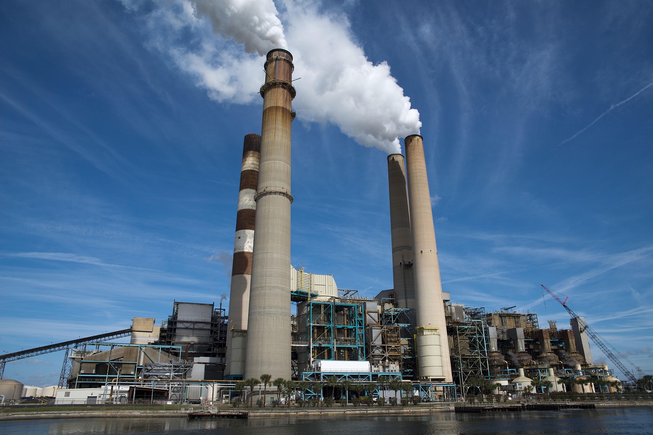
Soil and groundwater contamination constitute one of the most pressing challenges in contemporary environmental management, particularly in densely urbanised and industrialised regions, where historical land use has generated complex environmental liabilities that require long-term remediation. Worldwide, more than one million contaminated sites have been identified, most of them in developed countries. Approximately $83.5\%$ of these sites are located in Europe and $10.5\%$ in the Americas (Zhang et al., 2025). This distribution highlights the relevance of soil and groundwater contamination and the need for robust legislation, standardized methodologies, and centralized inventories to support remediation planning and ensure public transparency. However, several challenges exist in managing contaminated sites through inventories, including data complexity and integration across regions, legacy pollution, and the lack of unified global guidelines for pollutants (Carré et al., 2017; Chen, Gao, Li, 2025). Inventories of contaminated sites have been developed worldwide to support effective environmental management, exhibiting diverse structures, regulatory frameworks, and technological characteristics. Despite this progress, systematic analyses of these inventories remain scarce. Understanding the similarities and differences between these systems is crucial for identifying best practices and learning from existing systems to improve management approaches. Recently, several countries have made significant progress in improving their systems, incorporating new tools, enhancing public access, and strengthening legislative frameworks.
Contaminated site inventories are fundamentally critical, not just for meeting legislative and reporting mandates (EU Directive 2004/35/EC), but because they constitute the essential scientific baseline for addressing complex societal challenges (Crutzen, 2002). From a scientific perspective, these inventories are affected by data heterogeneity, as a mix of qualitative and quantitative records, varying detection limits, and spatial inaccuracies (Wang et al., 2021). This challenge is compounded by the issue of legacy pollution, where historically contaminated sites continue to pose persistent threats (Sun et al., 2021). Socially, the importance of these inventories is inseparable from the growing concern over environmental justice (Bullard, 1990); contamination disproportionately impacts vulnerable communities, making the inventory a key tool for identifying and rectifying socioeconomic inequalities in remediation (Walker, 2012). Furthermore, integrating emerging concepts like public health implications (Hu et al., 2020) and leveraging technological innovations such as AI-based mapping and remote sensing is vital. These advancements can help overcome institutional fragmentation and provide the high-resolution, dynamic data necessary to transform static lists of polluted sites into actionable information for protecting public health and ensuring a truly equitable environment (Tuia et al., 2023).
According to the European Environment Agency (EEA, 2024), most European countries have already established national, centralised inventories of contaminated sites, while others operate decentralised systems managed at the regional level, reflecting a high regulatory maturity. Italy, for example, launched its national database in 2020, made it publicly accessible online in 2023, and, beginning in 2025, has offered consultation through Web Map Services (WMS) and data downloads via Web Feature Services (WFS), in line with international standards. In China, the Law of the People's Republic of China on the Prevention and Control of Soil Pollution, in force since 2019, requires local governments to report contaminated land and mandates the creation of a national soil-environment database and a catalogue of construction land under risk control and remediation (NPCRC, 2019). These instruments are intended to support environmental management and remediation planning (NPCRC, 2019; FAO, 2021). In the Americas, in addition to Brazil, Mexico has established a publicly accessible national inventory of contaminated sites, providing a centralized database integrated with ArcGIS Web System (SEMARNAT, 2025). This initiative is strengthened by the Programa Nacional de Remediaction de Sitios Contaminados (PNRSC) from 2021 to 2024, which aims to keep the sites updated and identify trends in contamination (SEMARNAT, 2021).
In Brazil, the main regulatory framework for contaminated areas is the National Environmental Council (CONAMA) Resolution No. 420/2009, which establishes criteria and reference values for soil quality and defines guidelines for the management of areas contaminated by anthropogenic chemical substances. Article 38 of this resolution stipulates that competent environmental agencies must make information on identified contaminated areas publicly available, preferably through their institutional portals, while respecting legal confidentiality when applicable (CONAMA, 2009). The resolution also provides for broad dissemination of information on contaminated areas through formal communication to property owners, land registries, and municipalities, as well as through mechanisms for transparency and risk communication, including the publication of detailed reports on institutional portals (CONAMA, 2009).
Since 2013, the Government of the Rio de Janeiro State, through the State Environmental Institute (INEA), has published information on contaminated sites licensed for remediation, as well as those already rehabilitated, on the GeoINEA Portal (INEA, 2025a). Furthermore, Article 7 of the Rio de Janeiro State Environmental Council (CONEMA) Resolution No. 92, of June 24, 2021, requires municipalities to submit information on their environmental governance structures and licensing procedures to INEA. Building on this framework, INEA Resolution No. 306, of December 9, 2024, formally institutionalised the Contaminated and Rehabilitated Areas Inventory of the State of Rio de Janeiro (CRAI-RJ). Article 4 of this resolution establishes that INEA must ensure public access to information on contaminated and rehabilitated areas through the State Environmental Information System (SEIMA) and the Annual Diagnostic Report on Contaminated and Rehabilitated Areas in the State of Rio de Janeiro, thereby strengthening environmental transparency and governance (INEA, 2024).
The specific research gap about CRAI in the global literature motivated us to address this study. In this context, this article aims to comparatively analyse Contaminated and Rehabilitated Area Inventories (CRAI) at the international level and within Brazil, and to discuss their evolution in the Rio de Janeiro State. Specifically, it seeks to: (i) identify the main structural, regulatory, and technological elements that characterise advanced registration and management models; (ii) assess the alignment of CRAI-RJ with national guidelines and international best practices; (iii) examine the spatial distribution, types of contamination sources, and management stages recorded in the Rio de Janeiro State; and (iv) discuss recent advances, persistent challenges, and opportunities for consolidating the inventory as an instrument of environmental governance.
## II. METHODOLOGY
This study adopts a qualitative, exploratory, and comparative approach with the objective of analysing Contaminated and Rehabilitated Area Inventories (CRAI). Initially, a comprehensive international review was conducted to identify best practices and gaps in the standardisation of contaminated site registries, providing a foundation for assessing Brazilian systems within a broader global context. The selection of CRAI involved an extensive review in English and Portuguese languages of scientific and institutional databases, including Scopus, Web of Science, Google Scholar, governmental repositories, and technical reports published up to October 2025. The corpus comprised normative acts, official reports, scientific articles, and legal guidelines.
The selection prioritised countries that offer digital consultation mechanisms, georeferenced site data, contaminant reporting, and legislative support for CRAI implementation. To ensure a broader perspective and a view of all continental regions, international inventories from Brazil, Mexico, the Netherlands, the United States, Italy, Austria, China, Taiwan, and Australia were selected. In the African continent, South Africa also maintains a national contaminated land inventory, established under the National Environmental Management: Waste Act 59 of 2008 (RSA, 2009). However, during the period of this study, the official institutional website was inaccessible (IWMP, 2025), and
information regarding the structure and operational framework of the inventory could not be obtained; consequently, this country was excluded from the comparative analysis.
To examine similarities and specific features across CRAI systems, a set of key elements was defined and organised into thematic axes, as summarised in Table 1. This methodological design enables an in-depth comparative analysis and a critical assessment of the effectiveness of these inventories across different socioeconomic and institutional contexts.
Table 1: Criteria analysed in different CRAI, organised by thematic axes.
<table><tr><td>Thematic Axis</td><td>Criteria</td></tr><tr><td rowspan="4">1. Institutional Structure</td><td>Territorial scope</td></tr><tr><td>Location and access platform</td></tr><tr><td>Agency responsible for the registry</td></tr><tr><td>Legal/normative basis</td></tr><tr><td rowspan="2">2. Format and Technology</td><td>Tools used (Excel, web system, GIS, report)</td></tr><tr><td>Integration with other environmental databases</td></tr><tr><td rowspan="2">3. Access and Transparency</td><td>Year of first publication</td></tr><tr><td>Existence of online query mechanism</td></tr><tr><td rowspan="3">4. Technical Content</td><td>Recorded area classifications</td></tr><tr><td>Main information fields recorded</td></tr><tr><td>Publication of aggregated statistics</td></tr><tr><td rowspan="2">5. History and Evolution</td><td>Year in which the regulation establishing publication requirements was created</td></tr><tr><td>Recent reforms and modernisations (last five years)</td></tr></table>
Subsequently, a detailed review of legal and regulatory instruments related to contaminated site management at the federal, state, and municipal levels in Brazil, with particular attention to the Rio de Janeiro State was conducted. After that, a systematic assessment of the Contaminated and Rehabilitated Areas Inventory of Rio de Janeiro (CRAI-RJ) was carried out.
The CRAI-RJ, which is georeferenced and integrated into the State Environmental Information System (SEIMA) and accessible via the GeoINEA and Ambiente + platforms (INEA, 2025b), was analysed in terms of site distribution, contamination sources, and management stages as defined by CONAMA Resolution No. 420/2009. The categories considered were: Suspicious Area (AS), Contaminated Area under Investigation (AI), Contaminated Area under Intervention (ACI), Area under Monitoring for Rehabilitation (AMR), and Rehabilitated Area for Declared Use (AR).
## III. RESULTS AND DISCUSSION
### a) Contaminated and Rehabilitated Area Inventories: International Overview
The synthesis of information contributed to the identification of best practices and strategies that can be applied in other regions, aiming to improve public environmental policies and promote environmental justice (Hoelting et al., 2024). These Contaminated and Rehabilitated Areas Inventories serve as an official instrument for the means of disseminating information. Although approaches vary across geographic and socioeconomic contexts, CRAI generally share structural similarities and some key aspects. Table 2 presents these criteria from Brazil, Mexico, the Netherlands, the United States, Italy, Austria, China, Taiwan and Australia. CRAs as examples of structured inventories.
Table 2: Comparison of CRAI from Brazil, Mexico, Netherlands, United States, Italy, Austria, China, Taiwan and Australia.
<table><tr><td>Thematic axis</td><td>Criteria</td><td>Brazil</td><td>Mexico</td><td>Netherlands</td><td>United States</td><td>Italy</td><td>Austria</td><td>China</td><td>Taiwan</td><td>Australia</td></tr><tr><td rowspan="4">1. Institutional structure</td><td>Territorial scope</td><td>National</td><td>National</td><td>National</td><td>National</td><td>National</td><td>National</td><td>National</td><td>National</td><td>State/Regional</td></tr><tr><td>Location and access platform</td><td>BDNAC, IBAMA website</td><td>GeoPortal SEMARNAT</td><td>Bodermietet and Atlas Leformeving</td><td>The main one is the National Priorities List (NPL), EPA website</td><td>MOSAICO, ISPRA website</td><td>Allastensatlas, Altlasten Portal</td><td>Soil Environment Information Publicity Platform</td><td>Soil and Groundwater Pollution Remediation Website</td><td>Local EPA, NTEPA websites</td></tr><tr><td>Agency responsible for the registry</td><td>Brazilian Institute of Environment and Renewable Natural Resources (IBAMA) in coordination with state and municipal entities</td><td>Secretaria de Medio Ambiente y Recursos Naturales (SEMARNAT)</td><td>Ministry of Infrastructure and Water Management (Ministerie van Infrastructure en Waterstaat) in coordination with local authorities</td><td>Environmental Protection Agency (EPA) and state and local entities</td><td>Italian Institute for Environmental Protection and Research (ISPRA) in coordination with regional entities</td><td>Bundesministerium für Land- und Forstwirtschaft, Klima- und Umweltschutz, Regionen und Wasservitsch auf (BMLUK) in coordination with regional entities</td><td>Ministry of Ecology and Environment (MEE) in coordination with province entities</td><td>Environmental Management Administration (EMA)</td><td>Environment Protection Authority (EPA) and Northern Territory Environment Protection Authority (NTEPA)</td></tr><tr><td>Legal/normative basis</td><td>CONAMA Resolution No. 420/ 2009</td><td>NOM-147- SEMARNAT/SSA1-2004</td><td>Wet bodemeschering (Wbb), 1987, replaced in 2024 by Omgevingswet (Environmental and Planning Act, 2024)</td><td>Comprehensive Environmental Response, Compensation, and Liability Act (CERCLA), 1980; Hazardous and Solid Waste Amendments (HSWA), 1984</td><td>Legislative Decree 3, No. 152/2006, Art. 251.</td><td>Allastensatlas-VO (GBBI II Nr. 232/2004)</td><td>Order No. 42 of the Ministry of Environmental Protection, 2016</td><td>Soil and Groundwater Pollution Remediation Act 2000</td><td>National Environment Protection (Assessment of Site Contamination) Measure, 1999</td></tr><tr><td rowspan="2">2. Format and technology</td><td>Tools used (Excel, web system, GIS, report)</td><td>Excel, web system, GIS and reports (varies according to state methodology)</td><td>Web system, GIS and reports</td><td>Web system and GIS</td><td>Web system and GIS</td><td>Excel, web system, GIS and reports</td><td>Web system, GIS and reports</td><td>Excel, Web system, GIS and reports</td><td>Web system and GIS</td><td>Web system, excel and GIS</td></tr><tr><td>Integration with other environmental databases</td><td>Partial</td><td>N/A</td><td>Yes</td><td>N/A</td><td>N/A</td><td>N/A</td><td>Yes</td><td>N/A</td><td>Yes</td></tr><tr><td rowspan="2">3. Access and Transparency</td><td>Year of first publication</td><td>2010</td><td>N/A</td><td>N/A</td><td>N/A</td><td>2023</td><td>N/A</td><td>2018</td><td>2002</td><td>1999</td></tr><tr><td>Existence of online query mechanism</td><td>Available in some states</td><td>Yes</td><td>Yes</td><td>Yes</td><td>Yes</td><td>Yes</td><td>Yes</td><td>Yes</td><td>Yes</td></tr><tr><td rowspan="3">4. Technical content</td><td>Recorded area classifications</td><td>Suspected contaminated area, contaminated area under investigation, contaminated area under intervention, area under monitoring for rehabilitation and area rehabilitated for declared use</td><td>Area with contaminated soil and area with remediated soil</td><td>Area with available data and unknown status, area under investigation, area under remediation, area investigated/ remediated and area with known history</td><td>Areas are not separated into management sequence classes; each area belongs to a specific program that maintains its own management system, covering investigation, remediation and monitoring</td><td>Area awaiting evaluation, potentially contaminated area, contaminated area and non contaminated area</td><td>Area with history of potentially polluting activity, area with history of potentially polluting activity that underwent evaluation and confirmed contaminated area</td><td>Suspected contaminated area, confirmed contaminated area, risk-level classification of contaminated areas, contaminated area under detailed investigation and contaminated area under risk assessment</td><td>Restricted-use area due to groundwater contamination, area under detailed investigation and contaminated area under remediation</td><td>Western Australia is the only state that has a structured classification: Report not substantiated, possibly contaminated – investigation required; not contaminated – unrestricted use; contaminated – restricted use, remediated for restricted use, contaminated – remediation required; and decontaminated</td></tr><tr><td>Main information fields recorded</td><td>Area identification, current activity and responsible party, contaminant type, cause of contamination, affected medium, total or affected area, control, intervention and rehabilitation measures, area status, and general administrative information</td><td>Area identification, contamination type, cause of contamination, remediation methods, surface area of remediated and contaminated land by state</td><td>N/A</td><td>Varies depending on the management program. For the national priority Superfund program: area identification and history, contaminants, affected medium, area status, registration context, and administrative information</td><td>Identification of the area, responsible party, competent authority, registration date, reason for registration, progress of remediation and intervention processes, national priority and administrative information</td><td>Area identification, activity, status, area description, contamination assessment, priority classification, remediation measures, monitoring and control, administrative information</td><td>Area identification, current activity and responsible party, contaminant type, cause of contamination; affected medium, total or affected area, control, intervention and rehabilitation measures, area status, and general administrative information</td><td>Area identification and activity, contamination type and concentration, affected medium, total area and area currently monitored, area status, and registration history</td><td>Varies depending on the management program. In general, it involves area and activity identification, contaminant type, and contaminated site management</td></tr><tr><td>Publication of aggregated statistics</td><td>At state level</td><td>Yes</td><td>N/A</td><td>N/A</td><td>At regional and national level</td><td>At regional and national level</td><td>N/A</td><td>At national level</td><td>At regional and national level</td></tr><tr><td>5. History and Evolution</td><td>Year in which the regulation establishing publication requirements was created</td><td>2009</td><td>N/A</td><td>N/A</td><td>N/A</td><td>2020</td><td>N/A</td><td>N/A</td><td>2001</td><td>1999</td></tr><tr><td rowspan="2"></td><td>Recent reforms and modernizations (last five years)</td><td>Changes in contaminated area classification criteria and modernization of web and GIS systems in some states</td><td>Availability of data extraction</td><td>N/A</td><td>N/A</td><td>Creation of the national information system on contaminated sites (MOSAICO)</td><td>Changes in contaminated area classification criteria and modernization of the GIS system</td><td>N/A</td><td>Modernization of the GIS system and availability of data extraction</td><td>Recent improvements included more advanced search functions, more detailed interactive maps, standardized data formats across states, and automatic integration of technical reports into GIS systems. There was also greater alignment with the NEPM and the PFAS NEMP</td></tr><tr><td>References adopted</td><td>IBAMA, 2022</td><td>SERMANAT, 2025</td><td>Rijkswaterstaat, 2025</td><td>US EPA, 2025</td><td>ISPRA, 2025</td><td>Umweltbundes amt, 2025</td><td>SCPC, 2017; SEIPP, 2021</td><td>MET, 2025</td><td>ACT Government (2025); NSW Government (2025)</td></tr></table>
The international comparison revealed a substantial variation in the institutional and regulatory structure among the analyzed countries, although all have converged towards digital, georeferenced, and continuously updated registries of contaminated areas within their territories. Regarding the disclosure of information on territorial scope, the majority of countries operate with unified systems of national scope. With the exception of Australia, which maintains separate inventories for each regional jurisdiction, all countries operate unified national databases that centralize information across the entire territory under a federal or national authority. However, segmented models, where different programs or information portals maintain their own databases, are observed in countries such as the Netherlands and the United States. This decentralization of information publicity does not necessarily compromise the technological maturity of these nations. This diversity underscores that no single institutional model exists, but rather a universal need for a specific legal/normative basis to make the CRAI available, with Environmental Protection Agencies or an equivalent ministerial body being the central entity responsible for the registry in almost all cases.
All analyzed systems provide public access through online portals, unequivocally demonstrating a global trend toward transparency. However, the data presented in Table 2 show that the depth of data integration and technological sophistication vary. Across all countries, recent reforms have focused on modernising GIS infrastructure, improving digital interfaces, enhancing data extraction in multiple formats, and refining criteria for classifying and prioritising sites. These developments indicate a global shift toward integrated, transparent, and methodologically robust registries, which are becoming increasingly essential for environmental governance, remediation planning, and land-use decision-making in densely urbanised and industrialised regions. Despite different levels of platform development, the analysed systems share core features such as georeferencing, contaminant registration, and the monitoring of site status. Countries such as the Netherlands, the United States, Australia, and Taiwan operate systems based on web systems and GIS, with recent reforms focused on advanced search functions, detailed interactive maps, and format standardization. Australia and China, for example, demonstrate integration with other environmental databases. This modernization indicates a global focus on transforming the inventory from a static list into a dynamic and interoperable tool. It is noteworthy that the difference in CRAI accessibility maturity is evident in the year of first publication; Taiwan and Australia established public access in 2002 and 1999, respectively, while Italy only published its national system in 2023, and Brazil still offers CRAI consultation only at the state level.
A critical difference observed in the CRAI systems lies in how countries categorize contaminated areas, which directly influences monitoring and reporting. Brazil, Italy, Austria, and Taiwan utilize structured classification systems that follow the progression of areas through the contaminated land management stages (Suspected Area, under Investigation, under Intervention, Rehabilitated), allowing for systematic monitoring until the areas achieve rehabilitation. Additionally, the recording of detailed information is a common practice, including area identification, contaminant type, cause of contamination, and the current remediation status. The publication of aggregated statistics is also a practice adopted in several countries (Mexico, Italy, Austria, and Taiwan), which is essential for reporting and for macro-level assessment of management policy. In contrast, the United States manages contaminated areas through multiple national programmes, including Superfund (National Priorities List – NPL), RCRA Corrective Action, and the Underground Storage Tank (UST) programme (US EPA, 2025). These frameworks classify and prioritise sites according to factors such as the type and degree of contamination, risks to human health and the environment, the source of pollution, and the operational history of the contaminating activity.
Finally, this comparative approach makes it possible to identify best practices and persistent gaps in registry standardisation, thereby informing the evaluation of Brazilian CRAI in a global context.
### b) Contaminated and Rehabilitated Area Inventories: Brazilian Overview
Article 6 of CONAMA Resolution No. 420/2009, currently under revision, reinforces the responsibility of state and municipal environmental agencies to maintain and update their registries and to integrate them into the National Database on Contaminated Areas (BDNAC), with the goal to standardise and disseminate information at the national level (CONAMA, 2009).
According to the National Program for the Remediation of Contaminated Sites (2020), consultation of the BDNAC revealed that information on contaminated sites is available only for the States of São Paulo, Minas Gerais, and Rio de Janeiro, through links that redirect users to the respective state inventories. Pernambuco is also mentioned and discussed in the publication, although it does not have a specific inventory directly linked within the BDNAC framework.
The Environmental Agency of Pernambuco State (CPRH) hosts, on its website, a contaminated sites registry that is integrated into the Plan for Prevention, Preparedness, and Rapid Response to Environmental Emergencies Involving Hazardous Substances (Plano P2R2). Access to most information requires a login, and publicly available data are limited to spreadsheets listing contaminated sites associated with chemical accidents, organised by municipality and contamination source. Additional spreadsheets provide records of chemicals associated with commercial and industrial activities, incident histories, pollutant potential and facility size, as well as information on the transport of hazardous substances (CPRH, 2025).
In institutional terms, São Paulo, Rio de Janeiro, and Minas Gerais each have state environmental agencies responsible for managing their registries. São Paulo has the most consolidated model, supported by Decree No. 59,263/2023, whereas Minas Gerais still operates under Joint Normative Deliberation COPAM/CERH No. 02/2010. Rio de Janeiro, in turn, has advanced with INEA Resolution No. 306/2024, which coordinates the actions of the state agency with municipal authorities, thereby reinforcing the integrative character of environmental management.
In Brazil, instruments for registering, monitoring, and remediating contaminated sites have undergone gradual improvements, driven by the consolidation of state environmental policies and the implementation of geospatial information systems. With regarding to format and technology, all three states maintain digital and georeferenced registries, but differ in the complexity of their tools. Rio de Janeiro stands out for its diverse instruments, combining Excel spreadsheets, web-based systems, GIS platforms, and technical reports, which reflect recent efforts toward technological integration and improved transparency. São Paulo operates a GIS-based system with real-time reporting, demonstrating a high level of maturity and operational continuity. Minas
Gerais uses Excel and GIS, but does not provide real-time updates, limiting both efficiency and public dissemination, which is conducted solely through periodic reports referred to as inventories.
In terms of access and transparency, São Paulo and Rio de Janeiro offer public online consultation mechanisms. In contrast, Minas Gerais does not yet provide this functionality, thereby limiting access for civil society and the scientific community. As for technical content, the three states converge in their use of management categories that range from suspected contaminated areas to sites rehabilitated for declared use, with São Paulo presenting the most detailed classification of remediation stages.
From a quantitative perspective, São Paulo accounts for the most significant number of registered sites (7,051), followed by Minas Gerais (762) and Rio de Janeiro (525). This discrepancy reflects both São Paulo's higher level of industrialisation and more extended history of contamination, as well as the robustness of its system for identifying and updating data. The lower numbers observed in Rio de Janeiro and Minas Gerais indicate that their systems are still being consolidated, with ongoing improvements, particularly in terms of integration with municipal databases.
### c) Contaminated and Rehabilitated Area Inventories: Rio de Janeiro State Overview
Within this national context, the State of Rio de Janeiro stands out as an example of a system in consolidation, whose evolution over the past decade illustrates efforts to improve mechanisms for registering, monitoring, and ensuring transparency of information on contaminated sites. In 2013, the state released the first edition of CRAI-RJ. This initial report listed 151 contaminated sites, classified by type of activity: industrial facilities, waste landfills, passenger transport facilities, and fuel stations (INEA, 2025c). As technical and institutional arrangements evolved, the registry was progressively improved and, by its fourth edition, included more than 328 registered sites and a georeferenced version accessible through the GeoINEA Portal, which enables the integration of environmental data and the download of interactive maps (AREAS et al., 2017; INEA, 2025a).
The 2023-2025 Strategic Plan of the State Environmental Institute (INEA) established the development of support systems for managing contaminated and remediated sites as a strategic priority (RIO DE JANEIRO, 2023). Based on this guideline, in 2023, the Environmental Liabilities Recovery Management Unit (GERPASSI) was created within the Directorate for Post-Licensing and Environmental Inspection (DIRPOS). In partnership with the Territorial Management and Geospatial Information Unit (GERGET), GERPASSI developed specific procedures for implementing a new registry system for contaminated sites in the state.
The consolidation of contaminated site management in Rio de Janeiro has been accompanied by significant regulatory advances, aimed not only at creating and maintaining CRAI-RJ but also at standardising procedures for identifying, investigating, and rehabilitating such sites. One of the main milestones in this process is INEA Resolution No. 306, of December 9, 2024, which regulates the creation and maintenance of CRAI-RJ in accordance with Article 38 of CONAMA Resolution No. 420/2009 (CONAMA, 2009; INEA, 2024). This regulation formalised the management of the registry under GERPASSI and established technical and operational guidelines for integrating environmental information.
The consolidation process required compiling information from INEA's administrative systems, both physical and digital, including the Electronic Information System (SEI), which supports environmental licensing. This process established CRAI-RJ as a strategic instrument for information sharing and for strengthening territorial environmental management in the state. Standardised electronic forms were developed, including fields for cadastral identification, type of activity, current and intended land use, characterisation of pollutant chemical substances, risk scenarios, remediation measures, and implemented interventions. Approximately 500 administrative procedures were reviewed, and their data were updated in SEIMA (as illustrated in Figure 1), the GeoINEA Portal, and the Ambiente+ platform (INEA, 2025a; INEA, 2025b).
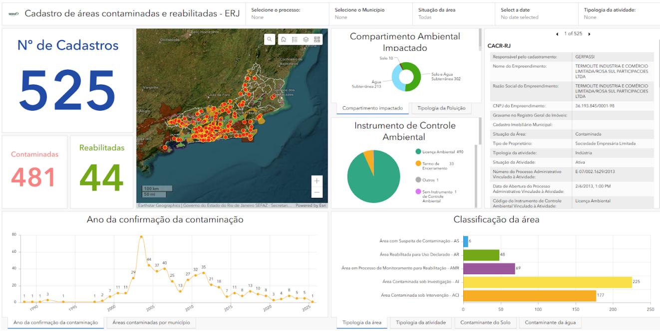 Figure 1: Control panel ("dashboard") of the SEIMA portal.
Source: INEA, 2025b.
Operation of the registry is carried out through SEIMA, which enables GERPASSI technicians and municipal agencies to register and update information within their respective jurisdictions (INEA, 2025b). Data validation occurs in a specific module of the ArcGIS Enterprise platform, ensuring the integration of local data into the state system and promoting standardised information and shared management of contaminated areas across the State of Rio de Janeiro.
Currently, sites in the registry are georeferenced as points, but the next version is expected to represent them as polygons. According to the Environmental Company of São Paulo State (CETESB, 2014), this change will enable a more accurate spatial characterisation of diffuse pollution scenarios, in which contaminant releases occur over extensive areas that may encompass multiple properties or urban and rural zones.
The CRAI-RJ database incorporates historical records, procedural updates from approximately 500 administrative processes, and contributions from municipal agencies, thus ensuring comprehensive coverage of environmental liabilities across the state. As of November 2025, the State of Rio de Janeiro had recorded 481 contaminated areas and 44 remediated areas, distributed across 60 municipalities. Most contaminated and remediated areas are concentrated in municipalities within the Rio de Janeiro Metropolitan Region, an area characterised by high population density and a strong presence of industrial, logistics, and petrochemical activities, which are sectors historically associated with the generation of environmental liabilities. This spatial distribution reveals a direct relationship between the intensity of anthropogenic activities and the incidence of
contamination, especially in urban and industrial centres such as Rio de Janeiro, Duque de Caxias, and São Gonçalo.
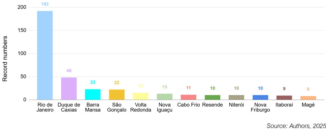 Figure 2: Geographic distribution of contaminated and remediated areas by municipalities in the state of Rio de Janeiro.
The Rio de Janeiro municipality accounts for the largest share of records, with 194 occurrences, corresponding to approximately $37\%$ of the state total, followed by Duque de Caxias (48 areas), Barra Mansa (23), and São Gonçalo (22) (Figure 2). This spatial pattern reflects the historical concentration of potentially polluting industrial and service activities in metropolitan areas and along major road and logistics corridors. These cities also exhibit cumulative effects of rapid urbanisation and industrialisation, historically characterised by weak environmental controls and inadequate management of hazardous waste and chemical substances, as highlighted in the literature (Panagos et al., 2013; Garcia et al., 2021). In this context, the State Register of Contaminated Areas plays a strategic role as a tool to support territorial planning, environmental management, and the definition of priorities for the investigation, monitoring, and remediation of environmental liabilities.
Regarding contamination sources, fuel stations account for the most significant proportion of contaminated areas in the State of Rio de Janeiro, totalling 309 cases (Figure 3), which corresponds to approximately $59\%$ of all records. This result is directly related to the widespread distribution of these facilities and the high frequency of incidents involving leaks of fuels and lubricating oils, the primary sources of soil and groundwater contamination associated with this type of activity.
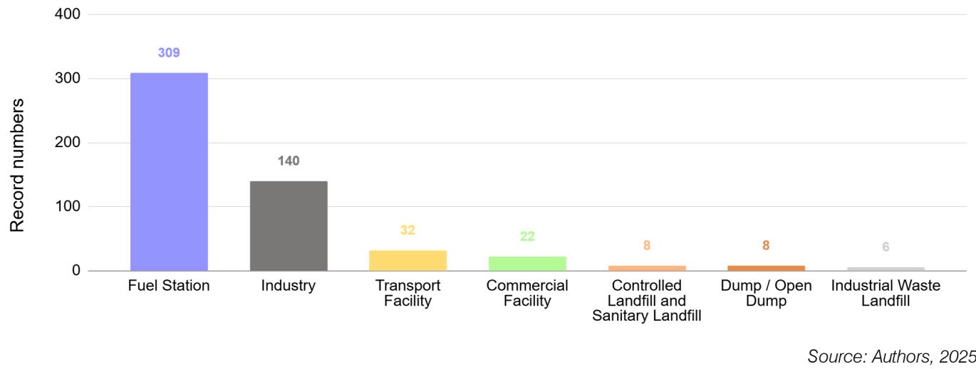 Figure 3: Contaminated and remediated areas: the type of activity responsible for contamination.
The predominance of areas in the initial (AS, AI) and intermediate (ACI) stages of the contaminated land management process $(77.7\%)$ underscores the complexity and long-term nature of environmental remediation in the state. It also reveals operational, institutional, and technical barriers that hinder the transition to more advanced stages, such as long-term monitoring and complete rehabilitation of sites. Although there are records of remediated areas in the State of Rio de Janeiro (9.1%), their proportion remains modest relative to the total number of registered sites, especially when compared with states such as São Paulo, where more than 30% of contaminated areas have already been officially remediated (CETESB, 2025).
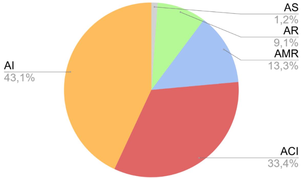 Figure 4: Classification of contaminated and remediated areas registered in CRAI-RJ.
Source:Authors,2025.
The predominance of areas in the initial (AS, AI) and intermediate (ACI) stages of the contaminated site management process $(77.7\%)$ reinforces the challenging nature of environmental remediation in the state. It reveals operational, institutional, and technical barriers that hinder the transition to more advanced stages of the process, such as final monitoring and complete rehabilitation of the site. Furthermore, although there are records of remediated areas in the State of Rio de Janeiro $(9.1\%)$, their proportion remains modest in relation to the total, especially when compared to states such as São Paulo, where more than $30\%$ of registered contaminated areas have already been officially remediated (CETESB, 2025).
#### Technical Capacity-Building and Municipal Integration
Since August 25, 2021, municipalities in the State of Rio de Janeiro have been responsible for licensing and registering contaminated sites under their jurisdiction (INEA, 2025b). Of the 92 towns in the state, 77 reported conducting environmental licensing, and 54 stated that they specifically license contaminated site remediation (INEA, 2025c). Integrating data on contaminated areas managed by these municipal authorities into CRAI-RJ is therefore a critical requirement.
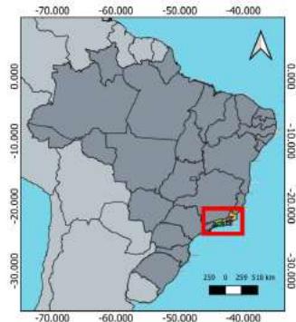 Hydrographic Regions of Rio de Janeiro State
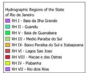
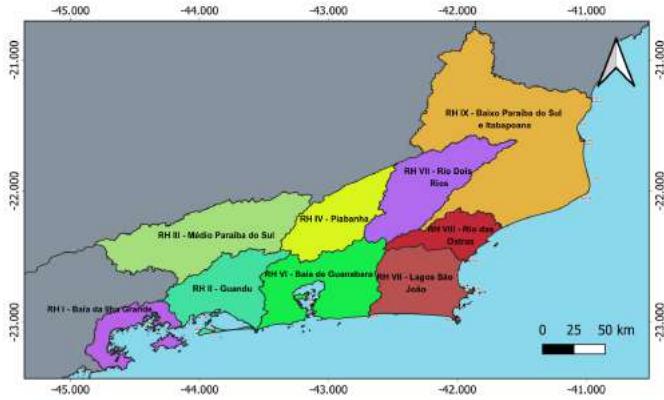 Figure 5: Hydrographic regions of the Rio de Janeiro State and their location in Brazil.
Source:Adapted from INEA,2025.
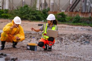
The training programs were closely aligned with INEA's Strategic Plan, particularly the initiative to "offer training in guidelines for identifying environmental liabilities," and with the guidelines of the State Secretariat for the Environment and Sustainability (SEAS) and INEA presented in the State Strategy and Action Plan for Biodiversity in Rio de Janeiro (EPAEB-RJ). This plan was developed in alignment with the Kunming-Montreal Global Biodiversity Framework, whose Specific Objective 4.4 calls for the reduction of environmental contamination. Action Line 2 of EPAEB-RJ emphasises the need to train municipal and state technicians to identify contamination and pollution, collect samples, and expand analytical capacity for contaminants (INEA, 2024).
## IV. CONCLUSION
The comparative assessment of contaminated and rehabilitated area inventories shows that Brazil, particularly the State of Rio de Janeiro, is moving towards a more integrated and transparent governance framework for soil and groundwater contamination, while still facing significant structural and operational challenges. By aligning CRAI-RJ with national regulations and international best practices, Rio de Janeiro has moved beyond a fragmented, case-by-case approach and established a more systematic architecture for registering, georeferencing, and monitoring environmental liabilities. The incorporation of standardised management categories, the integration of online platforms, and the explicit engagement of municipal authorities collectively enhance the state's capacity to identify priority areas, support regulatory enforcement, and inform land-use and territorial planning.
Fuel stations, logistics corridors and industrial clusters emerge as central nodes of contamination, reinforcing the need for sector-specific regulation, preventive controls, and long-term monitoring instruments. Strengthening the interface between contaminated site management, environmental licensing, and urban planning remains essential to prevent the re-production of environmental liabilities and to reduce socio-spatial inequalities in exposure to contaminated land. In view of the comparative framework with states and/or countries with greater maturity in contaminated land management, it is noted that for Rio de Janeiro to overcome the current operational stagnation in the effective rehabilitation of these areas, it is necessary to emulate governance innovations, namely the adoption of dedicated financial mechanisms and robust intersectoral integration among urban planning, health, and environmental agencies.
The consolidation of CRAI-RJ and other Brazilian inventories offers a strategic opportunity to deepen geospatial integration, expand public access to environmental information, and foster more participatory forms of environmental governance. Future research could explore the social and territorial dimensions of contaminated sites in greater detail, including their interactions with housing markets, infrastructure expansion, and environmental justice claims. From a policy perspective, for the contaminated land management policy to be effective and just, it must consider the integration of socio-economic vulnerability indices into the CRAI data. This measure is crucial to ensure that the inventory transcends its diagnostic function and establishes itself as a driver of Environmental Justice, prioritizing remediation in vulnerable areas where exposure to contaminants exacerbates existing socio-spatial inequalities. Thus, technological advancement and operational improvement must be directed towards mitigating disproportionate exposure risk and ensuring territorial equity.
Overall, the consolidation of contaminated site inventories, coupled with municipal integration, transparency, and standardised operational procedures, constitutes a strategic instrument for environmental governance. It supports the prioritisation of remediation actions, informs urban and regional planning in vulnerable areas, strengthens preventive and corrective measures, and contributes to the sustainable management of environmental liabilities.
The management of contaminated and rehabilitated sites is a critical component of contemporary environmental governance, particularly in regions characterised by intensive industrial, logistics, and urban development. In this context, the present study adopts a qualitative, exploratory, and comparative approach to analyse the structure and implementation of Contaminated and Rehabilitated Area Inventories (CRAI) worldwide and situates these experiences within the Brazilian context. First, an international comparative overview was conducted, examining consolidated registries in countries in different continents to identify global best practices and gaps in standardisation. This assessment is subsequently contextualised within the Brazilian framework, evaluating disparities and recent advancements among key state-level systems, with particular emphasis on the Rio de Janeiro State (RJ) as a representative case study. International experiences reveal significant variation in institutional arrangements, regulatory frameworks, and technological maturity. Despite this diversity, global trends point toward greater transparency, geospatial integration, and the use of standardised classification systems for managing contaminated sites. In recent years, Rio de Janeiro has made significant progress by institutionalising its CRAI, integrating it into the State Environmental Information System, and strengthening state-municipal coordination. As a result, by 2025 the state recorded 481 contaminated sites and 44 rehabilitated areas. However, most sites remain in the early or intermediate stages of management, underscoring persistent challenges related to remediation capacity, technical standardisation, and intergovernmental coordination. Overall, the study advances knowledge beyond existing literature by integrating international best practices of CRAI frameworks with state-level Brazilian governance. The findings offer evidence-based insights to strengthen the management of contaminated sites, highlighting opportunities for regulatory harmonisation, enhanced risk communication, and more informed decision-making in land-use planning and environmental remediation.
Our website is actively being updated, and changes may occur frequently. Please clear your browser cache if needed. For feedback or error reporting, please email [email protected]
×
This Page is Under Development
We are currently updating this article page for a better experience.
Thank you for connecting with us. We will respond to you shortly.