The presence of nature was evident in the cities and villages of Yemen -a country located on the southern tip of the Arabian Peninsula -with a varied topography between mountains, plains, deserts, and islands. Formerly Yemen was given many names. For example, the Greeks and Romans called it “Arabia Felix”, while Arab historians called it “green Yemen” due to its fertility, greenness, and picturesque nature. Ancient Yemeni settled in good geographical areas with suitable natural conditions and practised agriculture. Despite the rugged terrain of the mountainous heights, he built agricultural terraces on the mountains and found irrigation systems, so he dug wells and built dams such as the Ma’arib dam.
## I. INTRODUCTION
The presence of nature was evident in the cities and villages of Yemen - a country located on the southern tip of the Arabian Peninsula - with a varied topography between mountains, plains, deserts, and islands. Formerly Yemen was given many names. For example, the Greeks and Romans called it "Arbia Felix", while Arab historians called it "green Yemen" due to its fertility, greenness, and picturesque nature (Lehner, 1996). Ancient Yemeni settled in good geographical areas with suitable natural conditions and practiced agriculture. Despite the rugged terrain of the mountainous heights, he built agricultural terraces on the mountains and found irrigation systems, so he dug wells and built dams such as the Ma'arib dam (CSO et. al., 1994). As a result, settlements appeared that were not separated from nature but united or merged with it. The local architecture appeared integrated with the land, harmonious with the green spaces that permeate and surround it, which form a distinctive image in all its cities and towns, described by its visitors as a "total garden" (Ceccherini et. al., 1986)
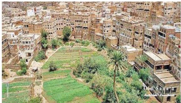
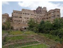
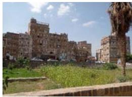
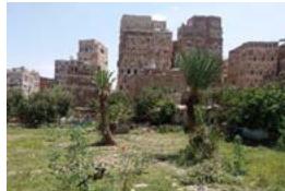
Sana'a old city is a vivid and extraordinary example of a traditional human settlement. A city at the foot of Nuqum mountain, founded by Shem, son of Noah, and inhabited for more than 2500 years. It played an essential role in many civilizations, including the Sabaean and Islamic ones. It was included in the World Heritage List in 1986 as a world cultural heritage and has gained wide attention (UNESCO, 2011). The city's urban fabric is one of its exceptional features, as it has preserved its components from the Middle Ages until now as a unique and authentic urban extension (Naeem, 2015). A masterpiece of a walled city with ornate, mud brick tower buildings interspersed with courtyards and green spaces. Together, they form an integration between urban fabric and nature. Green spaces exist in most of the city's neighborhoods. However, there are different types, this paper concentrate on two types that represent urban gardens, known as Miqshamah and Bustan due to their importance.
## II. A BRIEF HISTORY OF SANA'A OLD CITY
Sana'a city represented an essential political and economic center in the Arabian Peninsula. A city that has endured through the centuries with its decorated tower buildings rendered in gypsum, narrow and winding streets, and open and green spaces (Serageldin, 1995). Sana'a is located in the center of the Republic of Yemen, in the Central Region of the western mountains. Yemen's historian Al-Hamdani described it as the mother and pole of Yemen. Lies on the bottom of a plain surrounded from the east by Mount Nuqum and Mount Aiban from the west, from the south by Niqil Yasleh, and from the north by Shibam al-Firas (Al-Hadad, 1999).
The city has gone through different historical phases, divided into:
- Pre-Islamic era.
- Islamic era.
- Modern Era (Ottoman Rule and Beyond).
The first phase of Sana'a's history was characterized by mystery and legends. Because Sana'a was a populated city, it was not easy to study the archaeological record for this phase and relied only on written records (R B Serjeant and Ronald lewcock, 1983). However, it was found in the wall inscriptions that the southern Arabian region was inhabited from the eighth millennium BC (Lehner, 1996). The earliest mention of Sana'a in Yemeni inscriptions was around 70 CE (Baydani, 2001). The founder of Sanaa was Shem, son of Noah; he built the Ghumdan Palace and dug its well. Also, Sana'a was called Azal by its builder, Azal bin Yaqtn, who lived during the Sabaean era. Sana'a had a significant role during the period of the Sabaeans because it was a strong and impregnable city, so they called it Sana'a, which means the fortified town. Sana'a was subjected to the Abyssinian invasion and the Persian occupation in 575. Persian control of Yemen ended with the entry of Yemenis to Islam (Al-Taher, 2005).
The second phase began with the entry of Yemenis to Islam. Sana'a flourished, and its architecture developed and became a model for an Islamic city. The Great Mosque (Al-Jami Al-Kabir) was built by order of the Prophet Muhammad (R B Serjeant and Ronald lewcock, 1983). However, the city was affected by Islamic controversies, and this involved the city's expansion or decline. The buildings of Sana'a were counted in different periods, sometimes one hundred and twenty thousand houses and sometimes eighty thousand (Al-Hubaishi, 1980). In the third phase, Sana'a witnessed a rotation between Ottoman rule and the Imams. As a result, the city expanded toward the west (Bir Al-Azab and Qaa Al-Olufi), thus forming Sana'a historical city.
The urban fabric was affected by the historical and cultural phases that the city went through, so many architectural and urban elements interacted until they were adequately and acceptable integrated into all phases (Al-Shawesh, 2011). Residential and commercial areas were the city's main components. The market (Souk) represented the city's pole, extended from the main city gate (Bab al-Yamen) in the south to another Gate (Bab Shu'ub) in the north, and contained specialized markets and shops on the sides of the road (Laila Ahmed Haidara, Anuar Talib, 2013). The residential part consists of several areas, including the Al-Qate area, east of the market and near the palace. Al-Sarr Al-Sharqi area, which lies west of the market, is separated by Al-Sayilah from the third Al-Sarr Al-Gharbi area—followed by the fourth region represented by Bir Al-Azab and Al-Qaa.
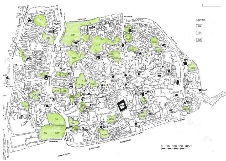
Sana'a old city has a compact and dense urban fabric containing 6,500 buildings and 48 historical mosques (masajid) and is surrounded by a wall that contains 9 gates. At its center is a commercial market that includes 2,000 shops, 48 specialized markets, 26 hotels (samaser), and 12 steam baths (Al-Shawesh, 2011). These elements formed building blocks punctuated by narrow meandering corridors that connect to open urban spaces. The forms of open spaces varied between squares (Sarha), areas of multiple sizes, and green spaces. The city contains 43 green spaces distributed in the city center and boundaries (Al-Taher, 2005).
## III. GREEN SPACES IN SANA'A OLD CITY
Green spaces are an essential and valuable part of the urban fabric of Sana'a old city, representing nature's easily regulated presence. It expressed nature's alliance with urban communities and the human need to communicate and interact with nature (Ceccherini et. al., 1986). The green spaces are linked with the mosque (Masjid) and the group of residential buildings in an integrative relationship, constituting the basic unit in forming the city's fabric. Also, they play an important environmental, economic, social, and aesthetic role in the city.
No information and documents are available about green spaces in Sana'a old city during the first historical period (Pre-Islamic era). However, in the second period (Islamic era), many historians described Sana'a city with its components, including its green spaces. For example, in the fourth century AH, Al-Razi described Sana'a and its mosques (masjid). Describing the Great Mosque, he mentioned that the area located on the masjid's left is better than its right and that when anyone comes out of the door on the left side of the masjid, they will find on the right "a garden from the gardens of Paradise" (Baydani, 2001).
This description matches the existing Miqshamah, located next to the Great Mosque (G30). Another description of Sana'a city during the rains, the torrents are directed toward green spaces to benefit from the rainwater (Al-Hubaishi, 1993). The buildings of Sana'a and other components were counted in different periods, mentioning that the houses were forty-five thousand and fifty-five green spaces in the days of al-Mansur Billah Ali ibn Salih (Al-Hubaishi, 1980).
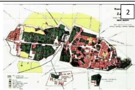
In the third period (Modern Era), many city maps were drawn during different periods. The first map was drawn in 1763 by Christine Niebuhr. Although the components of the city are not precise, green spaces separate the building block from the city wall in the north, east, and south. In 1879, Renzo Manzoni drew a map of the city, showing that green areas were defined as about $25\%$ of the area of the old city, while in the Ottoman Quarter (Bir Al-Azab and Al-Qaa), the green spaces were defined as about $75\%$. Finally, in 1929, Rathiens and Von Wissman drew the historical city. When comparing this map with the previous one, there are no differences in the percentage of green spaces in the two periods. The significant change that affected green spaces over nearly a hundred years appears by comparing the modern maps and aerial photographs with the Rathiens and Von Wissman map. Construction spread unfairly at the expense of the green areas in the Ottoman Quarter, so these areas were reduced or almost non-existent. As for the old city, the green spaces changed significantly in the western part of sayilah (Torrent path). In the Rathiens and Von Wissman map, the percentage of green spaces in this part was about $75\%$, while now only $25\%$ remain (Lehner, 1996). Green spaces currently occupy about 16.9 hectares, constituting $12.2\%$ of the city's total (Al-Taher, 2005). Figure 1.
### 3.1 Types of Green Spaces
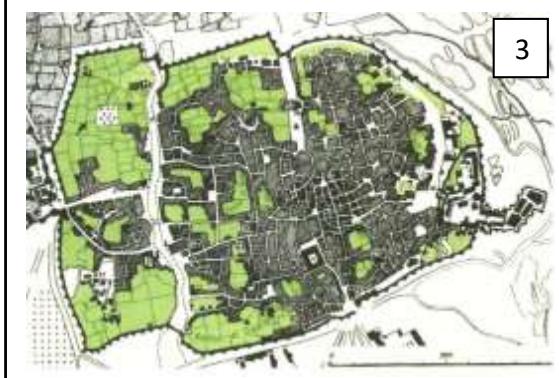
Green spaces in Sana'a old city - figure 2- are named under different terms due to their differences in the area, the feature of use, and the land ownership. Can be classified as follow (Al-Shawesh, 2017):
- 3.1.1 Miqshamah.
- 3.1.2 Bustan.
- 3.1.3 Residential building garden.
- 3.1.4 Roof Garden or Roof plants.
#### Defined as follows:
#### 3.1.1 Miqshamah
A small urban farm, an area for agricultural production within the walls of Sana'a old city. A functional element is considered a major income source for those in charge. And its ownership is a waqf. It specializes in cultivating vegetables consumed daily, such as radishes, leeks, onions, and aromatic plants (Barceló, 2004).
It is mentioned in the Yemeni Dictionary of Language and Heritage that "Qoshm is a plural name originally given to vegetables and fruits." Although it is common to associate the word Qoshmi with radish, its basis and meaning indicate the comprehensiveness of the types of vegetables and fruits. The name Maqshom was given to the small baskets that contained fruits. For example, when someone buys a small bowl or basket containing fruit, they call it maqshom figs. Based on Qoshm, the area in which it is grown is called Miqshamah. Moreover, its plurality is Maqashim, and the farmer is called Qasham (Al-Eryani, 1996).
#### 3.1.2 Bustan
A garden is larger than the area of Miqshamah and more diverse in its planting and trees. It is not the primary goal of productivity as a source of income because there are other sources, and their ownership is private. Vegetables with an undesirable smell, such as radishes and leeks, are not grown there. However, various vegetables and fruits, such as figs, pomegranates, grapes, and others, are grown in addition to roses and basil trees (Al-Taher, 2005). Bustan is an Arabic word that means "a garden with scattered trees and palms that can be planted between them," Its plural is Basateen (Dictionary, 2022).
#### 3.1.3 Residential Garden
The outer courtyard of residential buildings represents a miniature presence of nature in the yard of a single dwelling or residential group. It is limited in size, with little vegetation and space for daily activities (Al-Shawesh, 2017; Al-Taher, 2005).
#### 3.1.4 Roof plants
A group of shrubs, especially aromatic ones, are planted in pots and distributed on the roof of the residential building (Al-Shawesh, 2017).
Due to its practical and essential role, this study focuses on the first and second types of green spaces mentioned in the previous classification (Miqshamah and Bustan). Forty-three green spaces are distributed in the city center and edges, serving as the city's lungs and a source of connection to nature (Al-Afari, 2020). Urban gardens that produce vegetables and fruits, practical and aesthetic spaces that smell nature and tranquillity, are stable in the city's heart and isolated from the daily hustle (Barceló, 2004). Each green space has a name. For example, Maqashim were named after the associated mosque (masjid), while Basateen were named after the owner's family name. A list of green spaces is shown in table 1.
Table 1: Green Spaces (Lehner, 1996)
<table><tr><td>No.</td><td>Name</td><td>No.</td><td>Name</td></tr><tr><td>G1</td><td>Miqshamat Al-Hurqan</td><td>G23</td><td>Miqshamat Al-Washali</td></tr><tr><td>G2</td><td>Miqshamat Samrah</td><td>G24</td><td>Miqshamat Gamal Al-Din</td></tr><tr><td>G3</td><td>Miqshamat Samrah</td><td>G25</td><td>Miqshamat Maad</td></tr><tr><td>G4</td><td>Miqshamat Al-Tabari</td><td>G26</td><td>Miqshamat Al-Jadid</td></tr><tr><td>G5</td><td>Miqshamat Al-Nahryn</td><td>G27</td><td>Miqshamat Barrum</td></tr><tr><td>G6</td><td>Bustan Nahshal</td><td>G28</td><td>Miqshamat Al-Qasimi</td></tr><tr><td>G7</td><td>Bustan Al-Sultan</td><td>G29</td><td>Miqshamat Al-Abhar</td></tr><tr><td>G8</td><td>Bustan Al-Amri</td><td>G30</td><td>Miqshamat Aljami Al-Kabir</td></tr><tr><td>G9</td><td>Bustan Ingad</td><td>G31</td><td>Miqshamat Al-Shahidayn</td></tr><tr><td>G10</td><td>Bustan Al-Habal</td><td>G32</td><td>Miqshamat Ghozl Al-Basha</td></tr><tr><td>G11</td><td>Bustan Al-Habal/ Miqshamat Al-Alami</td><td>G33</td><td>Miqshamat Al-Zumor</td></tr><tr><td>G12</td><td>Miqshamat Mua'mar</td><td>G34</td><td>Miqshamat Al-Khudhir</td></tr><tr><td>G13</td><td>Miqshamat Al-Fulayhi</td><td>G35</td><td>Miqshamat Al-Khudhir</td></tr><tr><td>G14</td><td>Bustan Al-Na'man</td><td>G36</td><td>Miqshamat Al-Madrasah</td></tr><tr><td>G15</td><td>Bustan Al-Gauza</td><td>G37</td><td>Miqshamat Al-Madrasah</td></tr><tr><td>G16</td><td>Miqshamat Al-Jala'a</td><td>G38</td><td>Miqshamat Al-Tawashi</td></tr><tr><td>G17</td><td>Miqshamat Ibn Al-Hussein</td><td>G39</td><td>Miqshamat Al-Bakiryah</td></tr><tr><td>G18</td><td>Miqshamat Talha</td><td>G40</td><td>Miqshamat Salah Al-Din</td></tr><tr><td>G19</td><td>Miqshamat Tawuse</td><td>G41</td><td>Miqshamat Al-Humydi</td></tr><tr><td>G20</td><td>Miqshamat Dawud</td><td>G42</td><td>Miqshamat Musa</td></tr><tr><td>G21</td><td>Miqshamat Al-kharraz</td><td>G43</td><td>Miqshamat Al-Basha</td></tr><tr><td>G22</td><td>Bustan Dalal</td><td></td><td></td></tr></table>
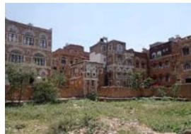
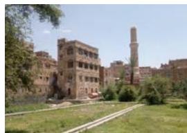
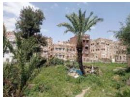
 Examples of some Magashim and Basateen (Top to bottom G6, G17, G20,G24,G28,G32) (Author)
#### 3.2 Characteristics of Green Spaces
Green spaces in Sana'a old city have many characteristics, the most important of which are in the following table 2:
Table 2: Characteristics of Green Spaces (Authors)
<table><tr><td>No</td><td>Characteristic</td><td>Description</td><td>No</td><td>Characteristic</td><td>Description</td></tr><tr><td>1</td><td>Basic Urban Component</td><td>1. Considered an urban component in an essential trilogy due to the water circulation system (Mosque, Steam bath, green space).2. Linked spatially to the mosques (masajid), and if the steam bath (Hamam) is found, it will be near them (Lehner, 1996).3. There is a well at every mosque, and water is collected in basins called Matahir, where the worshippers perform ablution and wash their feet before entering. Then, the purified water is drained into a pond to irrigation green space through canals. (Al-Hubaishi, 1993).</td><td>4</td><td>DepthFi Section showing green spaces level and street level CITATION AIT05 V 2057 (Al-Taher, 2005)(Edited by Author)</td><td>1. Its level is lower than the level of the city's streets.2. Differences in the depth may reach 4 m from the street level.3. The first possibility is that clay was taken from these areas as a building material. House was built around where the necessary building material was taken (Lehner, 1996).4. The second possibility, the level was deliberately reduced so that the torrents are drained to take advantage of it to irrigate the green spaces (Al-Taher, 2005).</td></tr><tr><td>2</td><td>Land Ownership</td><td>1. Waqf means that the property belongs to the state and cannot be sold or built in4. Preserved the existence of green spaces because Maqashim are waqf.3. Basateen are the private property of some of the old families in the city. (Naeem, 2015)</td><td>5</td><td>PrivacyG30 CITATION RIT86 V 2057 (Ceccherini et al., 1986)(Edited by Author)</td><td>1. A visitor to Sana'a old city is unaware of the presence of green spaces in their actual proportion.2. usually walled or surrounded by towers and its low level increases its privacy.3. Invisible to passers-by but are seen from the surrounding tower houses.4. The entrance is not straightforward. It cannot be reached quickly to preserve the privacy of the residents of the area, the farmers, and their families.5. Doubly hidden, a walled city contains walled gardens (Mackintosh-Smith, 2006).</td></tr><tr><td>3</td><td>Space and Shape</td><td>1. Linked to the water system, which requires building a slope called marna', starts with the well and descends in the opposite direction; the depth of the well limits its length.2. The animal moves in this path (marna'), pull the rope attached to the bucket to raise the water, and empties it into a pool. This made the path specify one of the minimum possible dimensions of one of the green space sides (Barceló, 2004).3. Basateen had no limitation for the area, as it is more extensive than Maqashim.4. The shape is determined by wrapping the residential buildings around them, forming polygons like a rectangle in some cases.</td><td>6</td><td>Agricultural ProductionAgricultural products</td><td>1. Has a triple for its continuity: water, soil, and human.2. Water is available from mosques (masajid), the soil is permanently fertilized with natural fertilizers, and the farmers take care of the land.3. Migshamah contains annual plants consumed daily, such as radishes, onions, leeks, salads, and aromatic plants, such as mint and basil.4. Palm trees were planted, and farmers benefited from their leaves as raw materials for making baskets and binding sold vegetables (Al-Shawesh, 2017).5. Basateen contains intense fruit trees, and space between the fruit trees may be planted with aromatic plants such as roses and basil. These trees bear fruit from once to twice a year and are for personal consumption. (Barceló, 2004)</td></tr></table>
#### 3.3 Role of Green Spaces
Green Spaces are functional elements in the city's fabric that play many roles, as follows:
## i. Environmental role
A city with a high density, tall, towering buildings, and narrow streets like Sana'a is in dire need of ventilation. Openings were opened in the direction of these spaces not only to get a view but to allow air movement (Lehner, 1996). The vegetation cover also purifies the air, raising the humidity and reducing the temperature and noise. Green spaces have an essential role in the disposal of waste figure 8. First, by using the waste ablution water from the mosque (masjid), the result of the presence of water is to benefit from it by growing vegetables and fruits. Second, by using solid human waste, this is done in a system as an integration that starts from a waste collection in a collection room located below the toilets in residential buildings. It is mixed with ashes, and after it dries, it is packed in fabric bags and transferred to steam baths, where the waste is used to heat the water by burning it, and all germs are eliminated through burning. Ashes are produced from this process and used as a natural fertilizer for the land (R B Serjeant and Ronald lewcock, 1983).
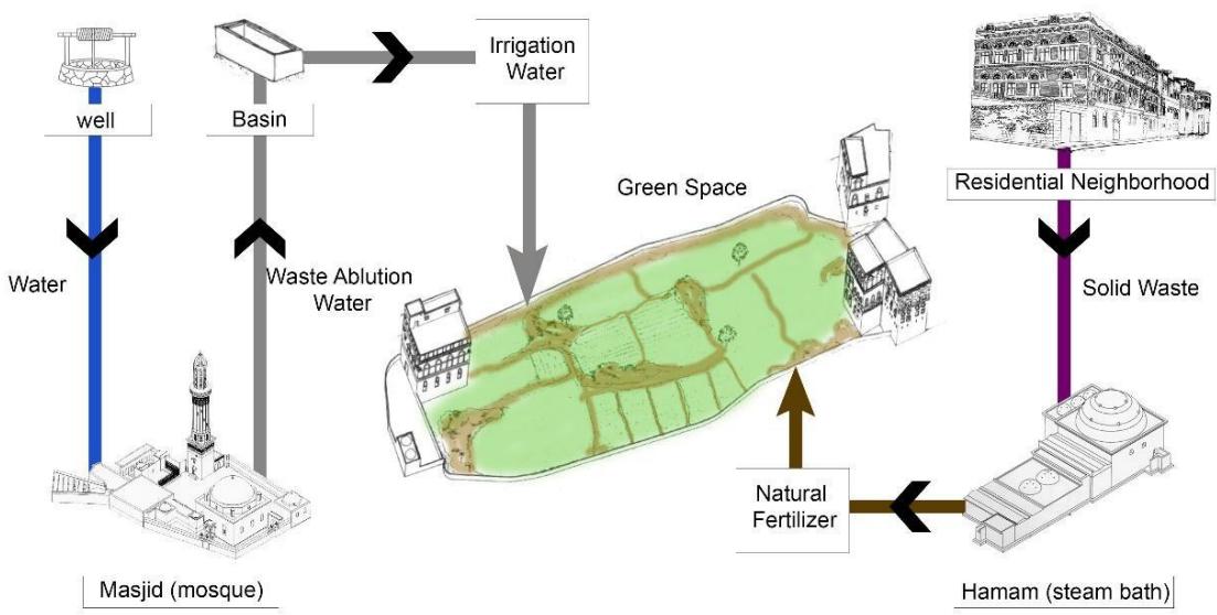 Figure 8: Waste Disposal System (Authors)
## ii. Economic role
The economic role was represented by being a productive element on which the farmers depended to provide their daily food base and to sell the surplus from the harvest. These spaces constituted a source of income for impoverished families and gave them the right to take care of the land and use it to provide services to the mosque (masjid), such as cleaning ponds and drawing water from wells. The financial condition of these families improved, and job opportunities were provided (Barceló, 2004). On the other hand, agricultural products played a significant role in making the city self-sufficient. Various vegetables are grown in Maqashim, seasonal fruits are grown in Basateen, and animal products for the animals found in, such as chickens, rabbits, goats, and camels. It is mentioned that Sana'a old city was self-sufficient by its green spaces when it was besieged for a whole year, and it was exposed to wars different time periods (Lehner, 1996).
## iii. Social role
The social role of Maqashim and Basateen lies in raising the level of a vulnerable social group (the farmers) and integrating them with society. Gatherings in these spaces while purchasing products and exchanging conversations between the residents and farmers strengthen social cohesion. Farmers' free distribution of basil after Friday's pray adds friendliness and intimacy to society. These spaces represent places for women to meet in the open air, as the privacy of green spaces enabled women to feel safe and gather there during the morning periods to exchange conversations.
## iv. Aesthetic role
Green spaces are the colour that brings vitality to a city with natural, earthy colours. They formed an inward-looking character for the dwellings as an inner courtyard, thus becoming an aesthetic element and a breather for the city (Al-Ghazali, 2005). A diverse view varies according to the level of vision, as the best way to enjoy the view of the green spaces is by overlooking them. Each floor of the tower buildings surrounding the green space has a distinct perspective, and higher floors have a more comprehensive view. As a result, more gardens reveal themselves, and the tops of trees mark the edges of other green spaces (Mackintosh-Smith, 2006).
## IV. EXISTING CONDITION
Green spaces constitute an essential and valuable part of the constituent elements of the city and express an indispensable free area in the urban fabric. However, the attention given to preserving the city's buildings and streets, green spaces have not been given the same attention as other components of the world's cultural heritage (Lehner, 1996). That caused a lack of information about green spaces in the city. Therefore, studying existing conditions relied on On-site spatial observation, interviews, aerial photos, and two studies prepared on green spaces in Sana'a old city were used as a reference to compare the past with the present. Brigitte Lehner prepared the first study in 1996, and a team directed by Miquel Barceló prepared the second study from 2000 to 2001.
Green spaces face many variables that deteriorate their conditions. Various factors caused a drastic change from what it was before. The existing condition was assessed by the following:
### 4.1 Space Decreasing
Green spaces represent a fragile agricultural area distributed throughout the city, facing rapid urbanization and urban sprawl. Until the middle of the twentieth century, it constituted more than $33\%$ of the city's total area (Al-Taher, 2005). However, that percentage has diminished because of the political changes in Yemen, the growth spurt that hit the city of Sana'a, and the construction spread of several green spaces.
Previous studies showed that green spaces decreased from 1962 until the study. Many changes have occurred in the green areas, especially Basateen, due to changes in owners' needs. Modern residential buildings were built on the edges of some green spaces, or spaces were invested for other uses. For example, Bustan Ingad and Al-Habal (G9-G10) became a market and an area for building stones. As a result, the number of Green spaces are decreased from 43 to 41 (Barceló, 2004).
Twenty years have passed since the last study for green spaces, bringing about many changes. Changes have appeared by comparing available maps, aerial photos, and site visits. A change in the area occurred in three cases, namely, Miqshamat Al-Nahryn (G5), Miqshamat Salah al-Din (G40), and Bustan Al-Habal/ Miqshamat Al-Alami (G11).
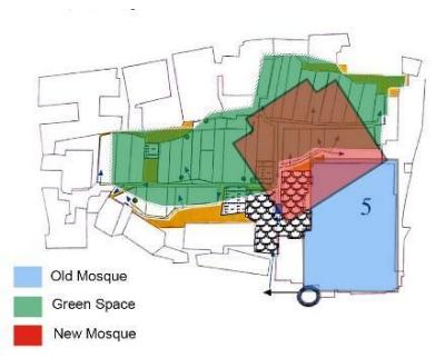
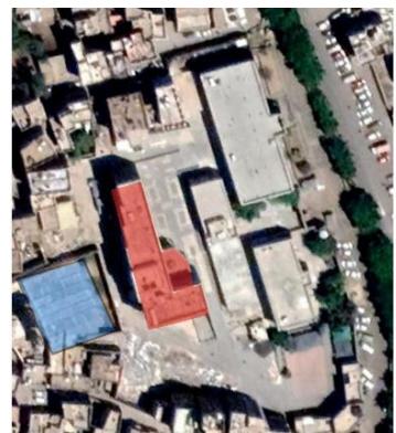
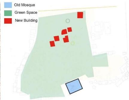
In the case of Miqshamat al-Nahryn (G5), following the demolition of the historic mosque by a decision by the Local authorities nearly two years ago, a new mosque is built (with modern design, construction methods, and materials) that extends over part of the Miqshamat as shown in Figure 9.
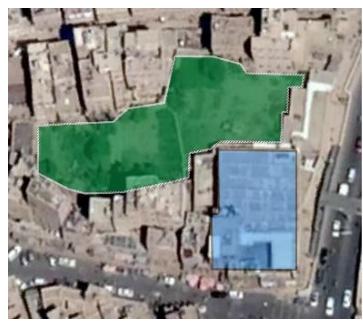 Aerial photo- Feb.2020 (Google Earth)
 Aerial photo-Aug.2022 (Google Earth)
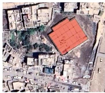
 G5 Map (Barceló, 2004) edited by Authors Figure 9: G5 Changes As for Miqshamat Salah al-Din, a military facility (with modern materials and methods) was built on its site several years ago, although the two studies in 1996 and 2001 mentioned its excellent condition and that it was fully planted. The result was noted through aerial photos and maps (no site visit due to the privacy of the military facility). Figure 10. Although the ownership of Maqashim returns to the Local authorities as a waqf and must protect it. Still, in the previous two cases, the Local authorities was the aggressor in these areas.
 Aerial photo-Dec.2004 (Google Earth
 Aerial photo- Aug.2022 (Google Earth)
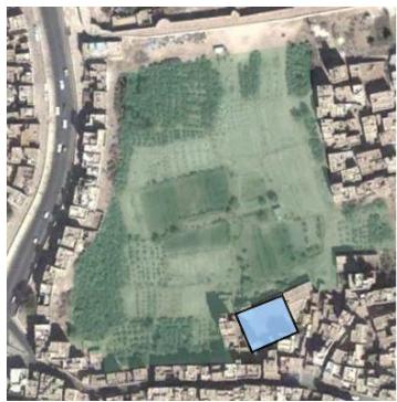
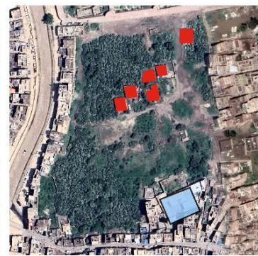
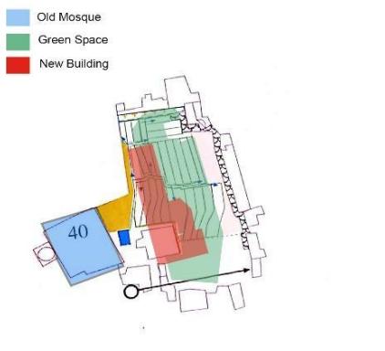 G40 Map (Barceló, 2004) edited by Authors Figure 10: G40 Changes In the case of Bustan Al-Habal/Miqshamat Al-Alami (G11), more than six apartment buildings were built. These buildings were located in the middle of the site, as shown in the figure 11.
 Aerial photo-Dec.2004 (Google Earth)
 Aerial photo- Aug.2022 (Google Earth)
 G40 Map (Barceló, 2004) edited by Authors Figure 11: G11 Changes As a result, the area of green spaces in the city decreased (regardless of its agricultural condition). These abuses constitute a danger that may affect more green spaces if these spaces are not protected. In conclusion, there are 41 green spaces in Sana'a old city, Bustan Ingad (G9) was excluded because it was transformed into a market, and Miqshamat Salah al-Din (G40) a military facility on it. Bustan Al-Habal (G10) has not been excluded as it was in part of a previous study because it can be revived. The rest of the cases presented were not excluded because they still have an area and may be planted in the future.
#### 4.2 Condition and use
At first glance, it is clear that the planted area does not match the total area of Green spaces. The depletion of wells and the scarcity of water supplied to green spaces are among the most critical factors that have caused a significant change in the existing condition. Also, paving the city's streets and Sayilah (flood path) without finding alternative systems to increase the groundwater level caused a severe problem. All of the above led to the drought of green spaces, and thus the city lost one of its most important wealth.
The conditions of several green spaces have changed, while others have become dumping grounds for waste or remnants of building materials. In addition, the use of some Basateen changed to suit the owners' desires.
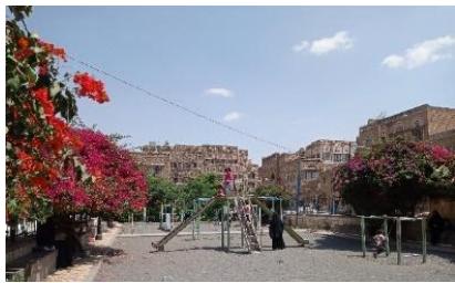
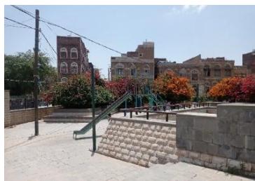
Lately, a type of green space (parks) appeared that was not present in the old city of Sana'a. Al-Na'man Park and Al-Tabari Park are located west of Al-Sayila and were established by the Municipality of the Capital. Al-Na'man Park was built on vacant land, while Al-Tabari Park was built on a wood market land both parks contain space for children, seating areas, and rose trees as shown in Figures 12, 13.
Eventually, due to the change in agricultural products, green spaces lost their connection to their names, such as Miqshamah and Bustan. Maqashim generally specialized in vegetable cultivation, and Basateen specialized in fruit cultivation. However, most Maqashim planted fruit trees in the current situation, and the cultivation of vegetables has declined to types and a limited area due to the lack of water. Vegetables need much water, unlike fruit trees that depend on seasonal rains. As for Basateen, the fruit trees have receded to a few types, including pomegranate, berries, and prickly pears.
## V. RESULTS
The green spaces gradually deteriorated due to the imbalance in agricultural production. As mentioned, water, soil, and human are the basis for the sustainability of these areas, so any change that happens to one of these components will affect the rest. The lack of water led to the drying up of green spaces, and the farmers stopped paying attention to the land, plowing and cultivating it. Due to the connection between the quality of green spaces with the farmers providing the necessary care, green spaces were classified into three categories:
- Farmed (receive care).
- Abandoned (no care).
- Change the use (other use).
The first category contains all the green spaces planted in whole or part, receive permanent care, and are irrigated periodically. The second category includes green spaces that do not receive the necessary care and are not irrigated but depend on seasonal rains. Usually, these green spaces contain mulberry, pomegranate, and prickly pear trees. Finally, the third category includes abandoned green spaces for other utilitarian purposes, such as parking lots or other activities shows in table 3.
Table 3: Classification and Percentage of Green Spaces (Author)
<table><tr><td>Classification</td><td>Percentage</td></tr><tr><td>Farmed (15)</td><td></td></tr><tr><td>G2- G3- G20- G21- G23- G24-</td><td rowspan="3">21% 35%</td></tr><tr><td>G25- G26- G28- G30- G32-</td></tr><tr><td>G34- G36- G37- G41</td></tr><tr><td>Abandoned (19)</td><td></td></tr><tr><td>G1- G6- G7- G8- G13- G14-</td><td rowspan="4">44%</td></tr><tr><td>G16- G17- G18- G19- G22-</td></tr><tr><td>G27- G29- G31- G33- G35-</td></tr><tr><td>G38- G42- G43</td></tr><tr><td>Change the use (9)</td><td></td></tr><tr><td>G4- G5- G9- G10- G11- G12-</td><td rowspan="2">farmed Abandoned other use</td></tr><tr><td>G15- G39- G40</td></tr></table>
As a result, 15 out of 42 Green spaces are planted (about $35\%$ ). They show the extent of the deterioration that affected the green spaces in the city. The farmers abandoned 19 green spaces due to a lack of water (about $44\%$ ). The old wells dried up, and deeper wells were dug during the past decades, reaching a depth of about $200\mathrm{m}$. However, the groundwater level declined until the wells' depth reached $500\mathrm{m}$ (G23). Although some artesian wells are inside some green spaces, the water is used for other purposes (G8). Formerly, Maqashim was watered from the pools of ablution water from the mosques (masajid), and although the basin still exists, the water that collects in is not enough. Some mosques (masajid) are no longer fed from wells; water is transported to them by trucks. This alarming deterioration poses a threat to the city's green space system. For many years, the dryness of green spaces made the community use these spaces differently (G9). 9 Dried green spaces are used for different functions as parking lots (G4, G11, G12, G15) or commercial markets (G9) (about $21\%$ ). Furthermore, if quick solutions are not found to tackle the deterioration, then in the coming years, the condition will deteriorate until the green spaces disappear from the city.
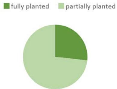 Table 4: Farmed Green Spaces Classification and Percentage Fully Planted
G25-G26 G28-G30
Partially Planted
G2-G3-G20-G21-G23-G24-G32-G34-
G36-G37-G41 In farmed areas that still receive care (15 Green spaces). Only four are fully planted and receive good care periodically. The remaining eleven are partially planted, and the area which is planted in them varies from one to the other.
It is noticeable that the cultivated green spaces have two irrigation water sources. For example, Miqshamaat Al-Washali (G23) contains an artesian well that feeds the neighboring mosques (masajid) and Al-Maqshim (G26, 28). In addition to ablution water is collected in basins. As for Miqshamat Aljami Al-Kabir (G30), the water coming from the mosque is abundant due to the large number of worshipers in the mosque because it is the oldest mosque (masjid) in Sana'a old city.
The partially planted areas may range from $50\%$ of their total area or less. The reason is the lack of water and the multiplicity of farmers who care about it. Some green spaces contain several families (some have a kinship relationship, and some are not), as some are interested in cultivating their area, while others do not plant and leave it dry (G21, 36). Accordingly, the percentage of the cultivated areas that are fully developed is $27\%$, and the partially cultivated is $73\%$ of the total area that receives care, figure 4.
Twenty-six years have passed since the study that Brigitte Lehner prepared for green spaces in Sana'a old city, and nearly 20 years have passed since the report of Miquel Barceló and his team. These years' political, economic, and social changes impacted the city's green spaces. A comparison between the past (represented by the two mentioned studies) and the existing condition is shown in the following, table 5:
Table 5: A comparison between the past and the present (Authors)
<table><tr><td>No.</td><td>Picture5</td><td>Lehner, 1996</td><td>Barceló, 2000-2001</td><td>Existing condition Sep.2022</td></tr><tr><td>G1</td><td></td><td>100% planted</td><td>Farmed and in good condition</td><td>Abandoned</td></tr><tr><td>G2</td><td></td><td>0 -10% planted</td><td>Farmed and in good condition</td><td>Partially planted</td></tr><tr><td>G3</td><td></td><td>30 - 40% planted</td><td>Abandoned and had another use</td><td>Partially planted</td></tr><tr><td>G4</td><td>Could not take a picture</td><td>60 - 75% planted</td><td>Farmed but in bad condition</td><td>Abandoned and had another use</td></tr><tr><td>G5</td><td></td><td>100% planted</td><td>Farmed and in good condition</td><td>Abandoned and had another use</td></tr><tr><td>G6</td><td></td><td>0 -10% planted</td><td>-</td><td>Abandoned</td></tr><tr><td>G7</td><td></td><td>100% planted</td><td>Farmed and in good condition</td><td>Abandoned</td></tr><tr><td>G8</td><td></td><td>100% planted</td><td>Farmed and in good condition</td><td>Abandoned</td></tr><tr><td>G9</td><td></td><td>0 -10% planted</td><td>Another use (market)</td><td>Another use (market)</td></tr><tr><td>G10</td><td></td><td>0 -10% planted</td><td>Abandoned</td><td>Another use</td></tr><tr><td>G11</td><td></td><td>50% planted</td><td>Under restoration</td><td>Abandoned and had another use</td></tr><tr><td>G12</td><td></td><td>50% planted</td><td>Farmed and in good condition</td><td>Abandoned and had another use</td></tr><tr><td>G13</td><td></td><td>60 – 75% planted</td><td>Farmed and in good condition</td><td>Abandoned</td></tr><tr><td>G14</td><td></td><td>100% planted</td><td>Farmed and in good condition</td><td>Abandoned</td></tr><tr><td>G15</td><td></td><td>30 – 40% planted</td><td>Abandoned</td><td>Abandoned and had another use</td></tr><tr><td>G16</td><td></td><td>60 – 75% planted</td><td>Under restoration</td><td>Abandoned</td></tr><tr><td>G17</td><td></td><td>30 - 40% planted</td><td>Under restoration</td><td>Abandoned</td></tr><tr><td>G18</td><td></td><td>0 -10% planted</td><td>Farmed seasonally (only in summer)</td><td>Abandoned</td></tr><tr><td>G19</td><td></td><td>0 -10% planted</td><td>Farmed seasonally (only in summer)</td><td>Abandoned</td></tr><tr><td>G20</td><td></td><td>50% planted</td><td>Under restoration</td><td>Partially planted</td></tr><tr><td>G21</td><td></td><td>60 - 75% planted</td><td>Farmed but in bad condition</td><td>Partially planted</td></tr><tr><td>G22</td><td></td><td>0 -10% planted</td><td>Abandoned</td><td>Abandoned</td></tr><tr><td>G23</td><td></td><td>80 - 90% planted</td><td>Farmed and in good condition</td><td>Partially planted</td></tr><tr><td>G24</td><td></td><td>80 – 90% planted</td><td>Under restoration</td><td>Partially planted</td></tr><tr><td>G25</td><td></td><td>100% planted</td><td>Farmed and in good condition</td><td>Fully planted</td></tr><tr><td>G26</td><td></td><td>100% planted</td><td>Farmed and in good condition</td><td>Fully planted but in a bad condition</td></tr><tr><td>G27</td><td></td><td>50% planted</td><td>Abandoned</td><td>Abandoned</td></tr><tr><td>G28</td><td></td><td>100% planted</td><td>Farmed and in good condition</td><td>Fully planted</td></tr><tr><td>G29</td><td></td><td>0 – 10% planted</td><td>Farmed but in bad condition</td><td>Abandoned</td></tr><tr><td>G30</td><td></td><td>100% planted</td><td>Farmed and in good condition</td><td>Fully planted</td></tr><tr><td>G31</td><td>Could not take a picture</td><td>30 – 40% planted</td><td>Farmed and in good condition</td><td>Abandoned</td></tr><tr><td>G32</td><td></td><td>80 – 90% planted</td><td>Partially farmed and in bad condition</td><td>Partially planted</td></tr><tr><td>G33</td><td></td><td>0 – 10% planted</td><td>Abandoned</td><td>Abandoned</td></tr><tr><td>G34</td><td></td><td>100% planted</td><td>Farmed and in good condition</td><td>Partially planted</td></tr><tr><td>G35</td><td>Could not take a picture</td><td>0 – 10% planted</td><td>Abandoned (except for a small farmed part)</td><td>Abandoned</td></tr><tr><td>G36</td><td></td><td>100% planted</td><td>Farmed and in good condition</td><td>Partially planted</td></tr><tr><td>G37</td><td></td><td>100% planted</td><td>Farmed and in good condition</td><td>Partially planted</td></tr><tr><td>G38</td><td></td><td>100% planted</td><td>Farmed and in good condition</td><td>Abandoned</td></tr><tr><td>G39</td><td>Could not take a picture</td><td>100% planted</td><td>Farmed and in good condition</td><td>Another use</td></tr><tr><td>G40</td><td>Could not take a picture</td><td>100% planted</td><td>Farmed and in good condition</td><td>Another use</td></tr><tr><td>G41</td><td></td><td>100% planted</td><td>Farmed and in good condition</td><td>Partially planted</td></tr><tr><td>G42</td><td></td><td>0-10% planted</td><td>Under restoration</td><td>Abandoned</td></tr><tr><td>G43</td><td>Could not take a picture</td><td>0-10% planted</td><td>Abandoned</td><td>Abandoned</td></tr></table>
Changes in the state of green spaces happened during the periods specified in the above table. The situation worsened in 17 green spaces (G1, G4, G5, G7, G8, G11, G12, G13, G14, G15, G16, G17, G27, G31, G38, G39, G40). These spaces were planted, some of which were in excellent condition, but now they are abandoned. On the other hand, 23 green spaces remained in their original state (G3, G6, G9, G10, G18, G19, G22, G23, G24, G25, G26, G28, G29, G30, G32, G33, G34, G35, G36, G37, G41, G42, G43) whether it was planted or abandoned, with some differences as to whether it was wholly or partially planted. The situation of 3 green spaces has improved (G2, G20, G21), and they have been revived and planted again. This indicates the possibility of reviving the abandoned spaces in the future despite their poor condition in the current condition.
The green spaces operated in an environmentally, economically, and socially integrated system. This integration has been disrupted, and green spaces have lost many roles over the past centuries. The environmental, economic, social, and aesthetic status has changed, as shown in the table 6.
Table 6: Current Status of Green Spaces Roles
<table><tr><td>NO.</td><td>Current Status</td></tr><tr><td>Environmental Role</td><td>1. Water shortage, dry wells, and low groundwater level.
2. The change of the traditional irrigation system and the disappearance of its elements (well, marnaa, basin).
3. The change in the liquid and solid waste disposal, replacing it with a sewage system.
4. The change in traditional agriculture and its components (animals and natural fertilizers) and replacing them with industrial equipment and materials.
The farmer Ahmed Zaid expressed his concern about the groundwater level, as the depth of the artesian well has reached more than 500 m, and it is the only resource for mosques and nearby green spaces. He also no longer uses natural manure because it is unavailable, and he cannot afford the cost of industrial fertilizer. (G23)</td></tr><tr><td>Economic Role</td><td>1. Water shortage and the deterioration of agricultural production led to a deterioration in the standard of living of farmers and their families.
2. Competitive and alternative markets and agricultural products that provided products instead of what green spaces provided.
3. -Job opportunities changed, so some farmers left their profession and searched for governmental jobs, while the uneducated farmers took up simple daily jobs.
4. Search for alternative land outside the city to provide water as an alternative to the spaces inside the city.
The farmer Hussein Asabh takes good care of his Miqshamah (G25), yet he rented land outside the city in Bani Al-Harith area to cultivate it. The new land represents a source of income for him, as Miqshamah is no longer economically feasible and cannot be considered a good source of income.</td></tr><tr><td>Social Role</td><td>1. The social fabric has changed due to the political and economic changes that the city has undergone.
2. The increase in the number of family members of farmers (the heirs) led to the division of the green space into smaller plots for each family. The small area of agricultural lands belonging to each farmer of the same family reduced their production and financial returns, which caused their abandonment.
3. Throwing waste resulting from surrounding houses and the lack of awareness of the residents of the area about the importance of green space.
4. The encroachment and intrusion of children on green spaces and agricultural products.
5. Some farmers adhere to the profession of their ancestors and consider it a significant inheritance.
Cousins Muhammad and Yahya Al-Ma'ali, complain about the lack of water to cultivate their land (G38), despite their urgent desire to practice agriculture because it is a profession inherited from their ancestors.</td></tr><tr><td>Aesthetic Role</td><td>1. Several barren lands have lost their attractive landscape.
2. The presence of piles of remnants of building materials and waste causes visual pollution.
3. The decreased trees and agricultural plots make the space lose its aesthetic appearance.
Citizen Muhammad al-Ghail described his memories of Bustan Nahshel (G6) when his grandfather used to buy him the best types of nuts. He also mentioned that he used to live in one of the houses overlooking the green space and spend the afternoon in his house enjoying the view. Finally, he expressed his regret at what happened to green spaces in Sana'a Old City.</td></tr></table>
Green spaces are an essential component of the city's fabric. However, it has lost its importance and role in the city. This situation may pose a threat to the sustainability of these spaces.
### Recommendations
This study concluded with the following recommendations:
- Stop the deterioration of green spaces urgently and thoughtfully, find urgent solutions to revitalize them, and return them to their ecological system through the following:
- Provide water sources and use rainwater by harvesting it and collecting it in ground basins distributed near green spaces.
- Renew old irrigation systems in Mosques
- Remove waste from green spaces and raising awareness about maintaining the cleanliness of green spaces and imposing penalties for those who throw waste in them.
- Re-divide agricultural plots among family members (the heirs), redistribute the plots to the most interested farmers and obligate them to plant them.
- Economically revitalizing green spaces through:
- Rent green spaces (Maqashim) to farmers wishing to plant them from outside the inheriting families and oblige them to take care of these spaces and not harm them.
- Fertilize all agricultural areas at the expense of the competent authorities to obtain year-round revenue.
- Rehabilitate farmers and their families and empower the role of women in agriculture.
- Establish weekly markets for agricultural products and market the products by organizing agricultural events and festivals.
- Activate the social role of green spaces through:
- Educate the community about the importance and role of green spaces in the old city of Sana'a in particular and in the modern city of Sana'a in general, and present the dangers that threaten its existence.
- Allocate some green spaces to be community gardens where community members can participate in the planting.
- Encouraging farmers and providing them with the necessary care, such as health care, free of charge, at the expense of the local authorities, to support them in the continuity of the practice of agriculture.
- Establish public parks in abandoned orchards and allocate places for the activities of children and adults.
- Enact laws and activate strict penalties for anyone who causes damage to green spaces, whether community members or local authorities.
- Establish agricultural research unit concerned with green spaces within the General Organization for Preservation of Historic Cities in Yemen (GOPHCY) and provide research on the cultivation of new varieties and the revival of old ones.
- Involve the tourism sector in making internal trips for citizens and students of schools and universities to the green spaces in the Sana'a old city to inform them of their importance.
- Benefit from the sustainable agricultural thought, reactivate it in the old city and apply it in the modern parts of the city's extensions.
[^3]: The term refers to property permanently donated for a religious purpose or as a charity. It cannot be sold or used for purposes other than for which it was intended. _(p.4)_
Generating HTML Viewer...
References
22 Cites in Article
Ali Al-Afari,Mohammed Al-Madhaji,Nashwan Al-Ansi,Borhan Uddin,Ahmed Al-Hazmi (2020). Form and Content in Yemeni Architecture: Exploring Continuity Mechanisms of Heritage - A Case Study of Sana'a City.
M Al-Eryani (1996). FOREWORD.
Dalia Abdelfattah,Sahar Abdelwahab,Mohamed Eldars,Mohammed Mayhoub (2005). Evaluating the Impact of Lighting Conditions on Workers’ Safety and Health in Industrial Settings.
A Al-Hadad (1999). Sana'a History and Ancient Homes.
A Al-Hubaishi (1980). History of Sana'a by Ishaq bin Yahya bin Jarir Al-Tabari Al-San'ani (450 AH).
A Al-Hubaishi (1993). Sana'a description "Set from the Book of Character Publications.
S Al-Shawesh (2011). Enhancing the Climatic Performance of Urban Residential Spaces in Sana'a City -Yemen.
S Al-Shawesh (2017). Sustainability of Complexes and Residential Buildings in the Architecture of Sana`a Old City and Use it in Contemporary Architecture.
C Al-Taher (2005). The Principles of Architectural Design and Urban Planning in The Various Islamic Eras -An Analytical study on The Capital, Sana'a, the Republic of Yemen. Sana'a, Yemen.
Althawrah (2017). When COVID-19 silenced cities, birdsong recaptured its former glory.
M Barceló (2004). French Institute of Archeology and Social Sciences Sana'a, Social Fund for Development -Sana.
Wafa F Badulla,Dua’a H Al-Maqdi,Ebtesam S Bamahmood (2001). In Vitro Biopharmaceutical and Physicochemical Evaluation of Different Brands of Ciprofloxacin Marketed in Aden-Yemen.
Ceccherini (1986). The Town As A Garden: The Case of Yemen.
Cso (1994). Yeman Demographic and Maternal and Child Health Survey.
Dictionary (2022). Translation and Meaning in Almaany English Arabic Dictionary.
Laila Ahmed Haidara,Anuar Talib (2013). Adaptive Reuse in the Traditional Neighbourhood of the Old City Sana'a -Yemen.
B Lehner (1996). Gardens of Sana'a (Maqashim and Basateen) -as a model of an ancient Islamic cultural heritage.
T Mackintosh-Smith (2006). The Secret Gardens of Sana.
M Naeem (2015). An objective reading of the urban transformation of street use in the old city of Sana'a.
R B Serjeant,Ronald Lewcock (1983). Sana'a an Arabian Islamic City.
I Serageldin (1995). Architecture Beyond Architecture: Creativity And Social Transformations In Islamic Cultures The 1995 Aga Khan Award For Architecture.
Amy Strecker (2011). The 1972 UNESCO World Heritage Convention.
No ethics committee approval was required for this article type.
Data Availability
Not applicable for this article.
How to Cite This Article
Samira Saleh Hussein AlShawesh. 2026. \u201cGreen Spaces in Sana’a Old City – Yemen between Past to Present\u201d. Global Journal of Science Frontier Research - H: Environment & Environmental geology GJSFR-H Volume 22 (GJSFR Volume 22 Issue H7).
Explore published articles in an immersive Augmented Reality environment. Our platform converts research papers into interactive 3D books, allowing readers to view and interact with content using AR and VR compatible devices.
Your published article is automatically converted into a realistic 3D book. Flip through pages and read research papers in a more engaging and interactive format.
Our website is actively being updated, and changes may occur frequently. Please clear your browser cache if needed. For feedback or error reporting, please email [email protected]
Thank you for connecting with us. We will respond to you shortly.