It analyzes the expansion of the agricultural frontier and extractivist economies in the Southwestern Amazon, where the social and environmental impacts predominantly affect protected territories and rural communities. Based on the concepts of land conflicts and agribanditry, this analysis evaluates the forces of neoextractivist capital, which are intertwined with agribusiness policies that primarily weaken environmental regulations and territorial rights to concentrate public lands, leading to the deterritorialization of Amazonian peoples and the regional peasantry.
## I. INTRODUCTION
The text analyzes the territorial transformations underway in the Southwestern Amazon, relating the expansion of the agricultural frontier in protected areas and the territories of the traditional people and communities. The general assumption guiding the analysis is based on the understanding that, in the region, rural and territorial conflicts include conflicts against rights to nature, against traditional territories, and against the affirmation of the territorialities of the Amazonian peoples.
The concept of agribanditry (Silva, 2022) used in this analysis encapsulates the violence against traditional peoples and communities living in the Amazon Forest, highlighting new processes of political and economic expropriation that violate the rights guaranteed by the Federal Constitution to these social groups. In this regard, deforestation and systematic invasions of protected territories reveal the spatial demands of neoextractivist economies (Bunker, 1985). The dominant notion of agro as an economic model in the Amazon generates political coalitions with utilitarian economic and territorial perspectives, leading to the destruction of the Amazon biome, which, in practical terms, undermines the territorialized ways of life in the forest (CPT, 2022).
The region under analysis—the Southwestern Amazon—comprises the northern part of the state of
Rondônia, the southern part of the state of Amazonas, and the eastern part of the state of Acre, which in recent years has experienced successive increases in deforestation, livestock expansion, invasions of protected areas, and conflicts over land and territory. The analysis is based on a specialized literature review, the organization of data provided by the Pastoral Land Commission (CPT, 2022), and field research conducted in the municipalities of Porto Velho (Rondônia), Humaitá, Lábrea, and Boca do Acre (southern Amazonas).
Following the introduction, the text is structured into three sections. The first section analyzes the process of economic modernization, driven by infrastructure policies, productive expansion, migration, and agricultural colonization, which has led to spatial differentiation in the Amazon, centred on: i) metropolitan regions and regional capitals; and ii) emerging agricultural regions. In the second section, the concept of agribandity underlies the analysis of agrarian conflicts in the Southwestern Amazon. It argues that the forces of neoextractivist capital in line with agribusiness policies, weaken environmental regulations and territorial rights to concentrate public lands, leading to the deterritorialization of Amazonian peoples and the regional peasantry. In the final considerations, he connects the (re)insourcing of the Brazilian economy with the pressures on protected areas, where agribandity emerges as a political process that drives agrarian and territorial conflicts in the Amazon.
## II. ECONOMIC MODERNIZATION AND SPATIAL DIFFERENTIATION IN THE AMAZON
The socioeconomic transformations in the Amazon, especially from the 1960s onwards, made it the focus of regional development policies. Initially implemented during the military dictatorship, these policies established an economic model based on the intensive exploitation of natural resources, expanding the commodification of nature and its corollaries at various scales—namely, socio-environmental impacts and the land-grabbing[^2] of public lands.
The scholarly literature on Amazonian studies has conceptualized these processes as economic and demographic modernization, pioneering fronts, and frontiers (Thery, 1976; Velho, 1979; Becker, 1982; Castro, 1997; Costa, 2005). In general, the regional economic dynamics led to converting forested areas into agricultural spaces, alongside colonization, migration, urban expansion, and infrastructure projects such as roads, hydroelectric plants, and mining. The state's "rediscovery" of the Amazon shifted public policies toward natural resource extraction and land commodification, turning the region into a reservoir of "natural assets." In this context, economic modernization refers to the techno-productive rationalization aimed at making the use of natural resources and territorial space more efficient for market circuits.
"Frontier" and "pioneering fronts" were analytical categories developed from geographical and social perspectives to explore the displacement of national society into the interior of the forest. They analyzed social conflicts in their scalar dimensions, the estrangement of lived worlds and the transient nature of space-time, where the social subjects affected by the frontier and economic modernization were subordinated in the 'new world' that capitalism created in the Amazon (Velho, 1972; Martins, 1997; Becker, 2004). This group includes Indigenous peoples, traditional communities, riverside dwellers, rubber tappers, migrant squatters, colonization settlers, and community leaders—both men and women (Amazonians and migrants)—who endured the hardships of Amazonian transformations, particularly during the 1960-1990 period, when major regional projects opened the Amazon to national and international economic and demographic flows.
The signs of these changes were rooted in urban expansion and the exploitation of nature by emerging social and economic groups, which were completely disconnected from the aesthetics of the Amazon. Society, shaped by the colonization occurring in the region, did not—and still does not—share an identity with the Amazon that welcomed it. This represents the invasion of the Center-South of Brazil into the Hileia, with its primary manifestations seen in the patterns of deforestation, roads, monocultures, environmental crime, new frontiers, and invasions of protected territories (Traditional Territories and Conservation Units).
Part of these processes took place during the military dictatorship, a period when the Amazon became a genuine laboratory for economic policies and violence against Indigenous peoples and traditional communities. Social conditions in the Amazon, particularly in rural areas, remain shaped by an authoritarian vision that viewed the region as a space for state expansion, neoextractivism, and colonization, influencing the relationships between the emerging society, nature, Amazonian peoples, and their traditional territories (CPT, 2022).
 Map 1: Legal Amazon, GDP distribution by municipality (2020)
Along this path, the image of progress was synonymous with the authoritarian state, which forged alliances with regional elites and emerging social groups, stemming from agricultural colonization and
migration policies. These groups would later form new local powers, built upon urban expansion and neoextractivist economies. The regional impact of economic growth in terms of gross domestic product (GDP) can be observed. In 2022, the GDP of the Legal Amazon, encompassing 772 municipalities across the states of the North region, Mato Grosso, and part of Maranhão, totaled R$752,932,026; in 2002, this figure was R$103,374,282. This means that over the past twenty years, the Amazon's economy has grown sevenfold, while Brazil's national economy has increased fivefold during the same period (IBGE, 2023).
The mapping of GDP by municipality indicates a spatially diffuse pattern (Map 1), shaped by federal interventions and state adjustments that prioritized the internalization of the regional economy. Spatial differentiation in the Amazon is evident in two main processes: first, the centrality of metropolitan regions and regional capitals, where economic growth is most prominent. Thus, the metropolises of Manaus, Belém, and São Luís take center stage, exerting influence in their respective states and playing a leading role in the economic dynamics. In smaller states, such as Acre, Roraima, and Amapá, the economic centrality of regional capitals is more significant for the state, given the low economic dynamism and limited productive internalization, constrained by insufficient territorial connectivity infrastructure.
The second process is characterized by the centrality of agricultural regions, reflected in the distribution and contribution of GDP by small and medium-sized municipalities, driven by the expansion of the agrarian economy and its connections to industrial plants and the services they require. The centrality in this process stems from agricultural colonization that began in the 1970s, supported by substantial government incentives for interregional migration, which shaped the territorial formation of these Amazonian subregions. This applies to the states of Mato Grosso, Tocantins, and Rondônia, where a network of smaller cities, economically subordinate to the political capitals, extends the regional economy, increasing the participatory distribution of municipalities in the production process. These situations are observed in the interior of Rondônia, particularly along the BR-364 highway corridor; in Mato Grosso, along the Cuiaba-Santarém highway (BR-163); in Tocantins, along the Belém-Brasília highway corridor (BR-010); and similarly, in the south and southeast of Pará, centered around Maraba.
From this second process—the centrality of agricultural regions—two interpretations emerged regarding their regional impact. Environmental studies and socio-environmental movements have called it the "arc of deforestation" (Domingues & Bermann, 2012). Driven by the growth of soy, livestock, and timber extraction, it encompasses 256 municipalities with high rates of deforestation, extending from western Maranhão, through the south and southeast of Pará, Mato Grosso, and Rondônia, and reaching the region of Rio Branco, the capital of Acre (ISA, 2019). The Belém-Brasília, Cuiaba-Porto Velho-Rio Branco, and Cuiaba-Santarém Road corridors serve as fronts for the expansion of neoextractivist economies, carrying a strong political and symbolic appeal of agribusiness.
In turn, Becker (2004) suggests that this vast region broadly represents the "arc of consolidated settlement", characterized by networks of cities interconnected by roads and anchored in the leading agricultural, livestock, and agribusiness activities. It is a segment of the agrarian economy (grains and livestock) and industrial chains (industries, agro-industries, and services related to agricultural demands) characterized by technological integration and its connection to production chains open to external flows. The author argues that the arc of consolidated settlement emerges as a sub-region, as public policies related to colonization, migration, and agriculture have provided regional coherence to this vast area of the Amazon.
In the 1990s, the federal government established the National Integration and Development Axes (Enids, in Portuguese), with an investment strategy focused on building logistics infrastructure to support Brazilian exports. In the Amazon, two axes were implemented: the West Axis and the Araguaia-Tocantins Axis. Particularly in the Southern Amazon (states of Rondônia and Mato Grosso) and southeastern Pará, the strategic vision for this region combined the expansion of agro-industry and agriculture, positioning it as a high-capacity regional logistics hub. The export demands for soybeans, corn, and meat required investments in logistics, which materialized with the opening of the Madeira-Amazonas waterway (1997), including the Hermasa/Amaggi and Cargill ports in Porto Velho, the Hermasa/Amaggi port in Itacoatiara, Amazonas, and the Cargill port in Santarém, western Pará (Costa Silva, 2013).
We can suggest that the colonization and migration policies developed between the 1960s and 1990s, alongside major infrastructure projects, produced spatial differentiation in the Amazon, with outcomes that are empirically evident in various aspects of social and economic relations. The formation of the arc of settlement led to the establishment of an agricultural region that, by intensifying agrarian production, pushed the frontier into other Amazonian subregions that had not yet faced the pressures of colonization and agriculture.
The economic growth and spatialization of the agricultural GDP in the Legal Amazon promoted political and social cultures centered on agricultural expansion, which entails increased consumption of natural resources. This contrasts with the traditional extractivist model, which dominated in the region until the 1960s, when cities and rural communities were shaped by river flows, and the forest was not perceived as a commodity. The agricultural and urban frontier introduced a logic of territorial expansion into the forest's interior.
In recent decades, the expansion of soybean cultivation has displaced livestock and logging activities to other Amazon subregions, either to western Pará along the BR-163 highway corridor or along the BR-364/230 highway routes, extending into northern Rondônia, eastern Acre, and southern Amazonas—a region we refer to as the Southwestern Amazon.
## III. AGRIBANDITRY AND AGRARIAN
### CONFLICTS IN THE SOUTHWESTERN
### AMAZON
The Southwestern Amazon encompasses the southern part of Amazonas, eastern Acre, and northern Rondônia. It is a sub-region traversed by the BR-364 (Rondônia-Acre), BR-317 (Acre-Amazonas), BR-230 (Transamazônia), and BR-319 (Porto Velho-Manaus) highways. It includes the regional capitals Porto Velho (Rondônia), Rio Branco and surrounding areas (Acre), and the cities along the Transamazônia—Humaitá, Apui, Lábrea, and Boca do Acre—accessible via the BR-317. The Madeira River plays a significant role in the region due to its network of territorialized riverine communities, hydroelectric plants, waterways, and private ports, and its status as a critical export corridor for commodities produced in western Mato Grosso and Rondônia (Silva & Costa Silva, 2022).
In this region, the Jirau and Santo Antonio hydroelectric plants on the Madeira River were established alongside road and waterway infrastructures, including the construction of two bridges over the Madeira River. One bridge, at the border with Bolivia, expanded the road network along the BR-364, facilitating more frequent connections between Rondônia and Acre. The second bridge, in Porto Velho, links to the BR-319, accelerating the agricultural frontier in northern Rondônia and southern Amazonas, with Humaitá as a focal point.
At the governmental level, federal and state authorities have proposed the Abunã-Madeira Sustainable Development Zone project (Sudam, 2021) for this region, initially referred to as Amacro (an acronym for Amazonas, Acre, and Rondônia). Governmental concern stems from evidence that this area has transformed into a new agricultural frontier characterized by expanding deforestation, invasions of protected areas, and increasing agrarian and territorial conflicts. This process accelerated under President Jair Bolsonaro's administration, during which public agencies responsible for territorial management and environmental oversight (FUNAI, Ibama, Icombio) were systematically weakened, undermining their institutional roles. This often included limiting the participation of the
Federal Police and Armed Forces in enforcement actions against illegal mining within conservation units and on Indigenous lands (Silva, Costa Silva & Lima, 2019).
The Southwestern Amazon faces the impacts of the encroachment of farming, mining, logging, and land-grabbing activities. A portion of the agricultural projects are funded by public banks, increasing pressure on the Amazon rainforest through rising land prices and expanding the agricultural frontier. According to an analysis by Bianca Santos and colleagues, in 2022, the Amacro region "accounted for $36\%$ of deforestation in the Legal Amazon. $52\%$ of deforestation was concentrated in four municipalities, with private properties responsible for $46\%$ of the deforestation" (Santos et al., 2023, pp. 2399-2402). Indeed, the interconnected deforestation fronts along the highways position Porto Velho (Rondônia), Lábrea, Apui, and Novo Aripuanã (all along the Transamazônia highway) as central hubs of environmental crime and agrarian conflicts.
These processes, observed during field research, were described by residents of the Transamazônia towns as the "Rondonization"3 of the Amazon, indicating that the expansion fronts, driven by the agrarian and timber sectors of Rondônia, are extending to land acquisition and land grabbing, alongside systematic invasions of protected areas, as seen in Boca do Acre, Lábrea, Apúí, and Realidade (a town in the municipality of Humaitá).
In this context, we propose the concept of agribanditry as "[...] a violent and aggressive face of the 'modern' Brazilian agribusiness" (Costa Silva, 2022, p. 108) that opposes environmental policies, but, above all, targets the protected territories of Indigenous peoples and traditional communities. Therefore, agribanditry emerges as a "[...] strategy expressed in violence against leaders and activists of social movements, environmental crime and invasive practices in protected areas, financing the theft of timber, mining, land grabbing and expulsion/threats to subjects living in the territory" (op. cit., p. 108). Agribanditry primarily targets so-called protected areas and leaders of social organizations who denounce these practices, such as activists and defenders of human and territorial rights. In other words, agribanditry operates against collective resources (state-owned natural resources), protected territories (public land designated for collective use), and the territorialities of Amazonian peoples (their cultures and ways of life).
The geography of land conflicts is expanding particularly in the Southwestern Amazon, driven by the advancing frontier. It is essential to differentiate among various categories of analysis related to these conflicts. The Pastoral Land Commission defines land conflicts as all "[...] actions of resistance and confrontation for the possession, use, and ownership of land and access to natural resources [...]". (CPT, 2022, p. 12). Within the context of these conflicts, agrarian and territorial conflicts can be distinguished. Agrarian conflicts refer to incidents involving land tenure in areas that are land-grabbed, unproductive, or occupied by social movements advocating for agrarian reform. Typically, the participants in these processes are squatters, landless individuals, small landowners, settlers, and peasants occupying or defending land ownership or possession through family-based work. Territorial conflicts, on the other hand, pertain to the defense of protected or claimed territories, where territoriality is expressed through Indigenous peoples,quilombola communities, and traditional communities. Indigenous lands,quilombola territories, and Conservation Units (UCs) constitute the set of protected territories—a geographical space of experience, usufruct, and social reproduction guaranteed by the Federal Constitution (Souza Filho et al., 2015). Agribanditry operates primarily in protected areas, aiming at the appropriating traditional territories or environmental plunder, as the economy of ecological crime becomes a strategy for both capital accumulation and the deterritorialization of Amazonian peoples.
In the first scenario, the focus is on defending and securing land tenure and access to family-owned property; in the second, it concerns federal or state public lands designated for collective use and social reproduction. Thus, both the struggles of settlers and those of Indigenous peoples and traditional communities are fundamentally struggles for territory, as they represent a collective rooted in family-based work, the defense of nature, and the recognition of social and territorial rights. The collective, family-oriented, sociocultural, and public nature of the territories of the peasantry, Indigenous peoples, and traditional communities contrasts sharply with the privatizing, exclusionary, deterritorializing, and monopolistic nature of capital that thrives in neo-extractivist economies. In this context, rural settlements, characterized by productive diversity and family labor, are territories of the peasantry—territories of life! Private family property should not be conflated with capitalist property, as is the case in areas dominated by monoculture. There are substantial sociological and geographical differences.
In the past, the so-called land-grabbing industry targeted vacant public lands. Today, its strategy, in alliance with agribandity, targets protected areas, often mobilizing and financing small squatters, effectively creating a form of "outsourced land grabbing". Consequently, the push to reduce protected areas, as seen in the Legislative Assemblies of Acre, Rondônia, Mato Grosso, and Amazonas, aligns with the urgency of land regularization, which has become a pathway for the legalization of land grabbing. In general, most of the disputed areas have shifted in recent years to protected territories, legally recognized by the State (Federal and State).
Territorialities in the agrarian world position the Amazon as a space for the social reproduction of the peasantry, Indigenous peoples, and traditional communities, especially due to the concentration of protected areas in the region. In turn, given the significant number of public lands designated as protected areas, the struggle over land has evolved into a dispute over territory—a trend that is likely to intensify with the expansion of agribusiness.
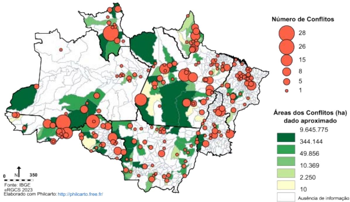 Map 2: Conflicts Over Land and Conflict Area in the Legal Amazon (2021) Source: CPT (2022). Elaboração: Autor
Costa Silva (2022, p. 109), analyzing the landscape of land conflicts in 2021 (Map 2), highlights the scale of these conflicts in the Amazon:
- In 2021, the Amazon accounted for $53\%$ of land conflicts in Brazil and involved $62\%$ of the families affected.
- Data from the Pastoral Land Commission (CPT) indicates that $97\%$ of conflict areas are in the Amazon, totaling 68,881,076 hectares. Most of these conflict areas are composed of Indigenous territories, rubber-tapping or extractivist territories—in other words, territories of Indigenous peoples and traditional communities that are legally protected.
- In the Amazon, $65\%$ of threats of expulsion, $67\%$ of pesticide contamination, $79\%$ of illegal deforestation, $87\%$ of expulsions, $81\%$ of land grabbing, $82\%$ of invasions, $70\%$ of instances of violence by hired gunmen, $75\%$ of state omissions or complicity, and $72\%$ of violations of living conditions occurred.
- Extractivist capital was responsible for $75\%$ of land conflicts, while state institutions accounted for $18\%$. Among the primary causes of conflicts, farmers were responsible for $27\%$, land grabbers for $14\%$, national and international entrepreneurs for $14\%$, loggers for $12\%$, and the federal government for $11\%$.
- As for social groups affected by these conflicts, Indigenous peoples (30%) suffered the highest rates of aggression, followed by squatters (22%),quilombolas (13%), and landless individuals (13%).
These data reveal the accelerated expropriation affecting all social segments, characterized by family-based work and multi-territoriality, as well as a commitment to the defense of nature. Territories are collective spaces of lived experiences, as seen in the experiences of Amazonian peoples, who face attacks from political groups and organic institutions of neoeextractivist economies, with agribusiness serving as the political, economic, and territorial driver of the dismantling of environmental protections in the Amazon.
In the National Congress, the ruralist-agribusiness caucus imposes strategies to destabilize protected areas, traditional territories, and the lands of the regional peasantry. Their institutional agenda seeks to reduce environmental protections and diminish the social and territorial rights established in the legal framework. Especially in the Amazon, agribanditry acts to weaken the territorial rights of Indigenous peoples and traditional communities.
In the Southwestern Amazon, land conflicts are distributed as follows: in Acre, 59 land conflicts were recorded in 2021, with squatters (42%) and rubber tappers (41%) being the groups that experienced the most violence. In Rondônia, 52 conflicts were recorded, with the landless (44%) and Indigenous peoples (21%) being the main victims. In Amazonas, with 62 conflicts, Indigenous peoples and squatters each accounted for 41% of the recorded instances of violence. Regarding the causes of these conflicts, the distribution is as follows: in Acre, farmers are primarily responsible for disputes (73%); in Rondônia, the main culprits are farmers (29%), loggers (21%), and land grabbers (15%); in Amazonas, the key actors are farmers (41%), land grabbers (22%), and loggers (16%) (CPT, 2021).
The states of Acre and Amazonas have recently faced the most intense pressures from neoextractivist economies. In the invaded territories of Acre, squatters who have long inhabited rural areas without land regularization stand out, as their lands are increasingly encroached upon by farmers and loggers from Rondônia. For rubber tappers, a traditional group historically rooted in extractivist reserves, their territories are particularly affected by agribanditry practices. In Amazonas, this situation impacts both Indigenous peoples and squatters, putting at risk the set of established Indigenous lands and precarious conditions of tenure and security, threatened by a wave of land grabbing and environmental exploitation. It is noteworthy that until a few years ago, this process did not have such a significant presence in Amazonian agrarian dynamics. In Rondônia, a state shaped by agricultural colonization and with a history of agrarian conflicts, such as the events in Corumbiara (1995), recent conflicts have increasingly impacted the landless population and Indigenous peoples.
In general, the social groups most affected by aggression are the most vulnerable in the Amazonian agrarian context. They find themselves in precarious conditions of land tenure or demarcated territories (protected areas) that are invaded by agribanditry. Those responsible for these conflicts represent the neoeextractivist political and economic agenda (farmers, land grabbers, miners, loggers, traders, and entrepreneurs), aligning with the political and territorial vision of agribusiness (CPT, 2022).
Agribanditry operates on several levels: at the governmental level, it aims to weaken public institutions for environmental and territorial protection; in the political arena, it engages in the National Congress and Legislative Assemblies, proposing bills and other legislative instruments that remove, reduce, or obstruct the environmental and territorial rights of Indigenous peoples and traditional communities. At times, they propose bills to grant amnesty, justify, or relax regulations on environmental crimes. In the social sphere, agribanditry manifests through boastful and imposing agricultural propaganda; in media statements claiming an exaggeration of environmental protections in Brazil; and in the narrative of agriculture as a symbol of modernity and the sole path to economic development for the Amazon, a message that finds acceptance in areas experiencing deforestation and frontier expansion. In these same areas, criticisms are directed toward public environmental protection agencies, social organizations advocating for Amazonian peoples and their territories, and, to a certain extent, research institutions and their researchers.
## IV. CONCLUDING REMARKS
The continuous growth of exports of primary products and their increasing contribution to Brazilian GDP is what economists generally refer to as the (re)insourcing of the economy (Lamoso, 2020). One of the spatial effects of this process is the relocation of neoextractivist economies to the Amazon, with implications that manifest in the invasions of protected areas and traditional territories. This represents, in essence, a rush for "new lands" and the large-scale appropriation of natural resources, converting them into physical stocks for neoextractivist economies.
However, these "new lands" are often already territorialized by Amazonian populations. Traditional communities sustain social life and shared territorialities in these areas, and their territorial rights have been recognized by the Brazilian State. For the social groups who live off the fields, forests, and waters, forming Amazonian multi-territorialities, the advance of the frontier into the Southwestern Amazon not only threatens their relationship with the land and collective labor but also imposes asymmetrical social relations that tend to weaken the social rights and territories guaranteed by the Federal Constitution.
In other words, the issue is not only about land access through possession and rural settlements, but also about the establishment of territories for Indigenous peoples and traditional communities, which are now targeted by agribanditry. This threatens what the Brazilian State, through the Constitution and public agencies, has minimally recognized as rights and dignity for those who live off the land and their territories—those who form the collectives that shape this country.
[^2]: "Land grabbing refers to the unauthorized appropriation of public lands for economic purposes. This practice is widespread in the Amazon, driven by neoeextractivist economies such as livestock, soy, timber, and mining, which transform the natural landscape into agricultural land, placing significant pressure on protected areas like Conservation Units, and Indigenous and Quilombola Lands. _(p.1)_
Generating HTML Viewer...
References
22 Cites in Article
B Becker (2004). Amazônia: geopolítica na virada do III milênio.
B Becker (1982). Geopolítica da Amazônia: a nova fronteira de recursos.
S Bunker (1985). Underdeveloping the Amazon: extraction, unequal exchange, and the failure of the modern state.
E Castro (1997). Território, biodiversidade e saberes de populações tradicionais.
R Costa Silva (2022). A desamazonização da Amazônia: conflitos agrários, violência e agrobandidagem.
R Costa Silva (2013). Globalização, agricultura e a formação do meio técnico-científico-Agribanditry and the Expansion of the Agricultural Frontier in the Southwestern Amazon (Brazil) Global Journal of Human-Social Science ( E ) XXIV Issue IV Version I Year 2024 7.
R Costa Silva,V Silva,L Lima (2019). Os novos eixos da fronteira na Amazônia ocidental.
Francisco Costa (2005). Questão agrária e macropolíticas para a Amazônia.
Geovan Soares,Tiago Schwade (2022). Disputas por terra e território na Região Metropolitana de Manaus: uma análise dos cadernos de conflitos no campo da Comissão Pastoral da Terra (CPT).
Mariana Domingues,Célio Bermann (2012). O arco de desflorestamento na Amazônia: da pecuária à soja.
(2021). Produto Interno Bruto dos Municípios.
Bárbara Vieira (2019). A cobertura do jornal O Estado de S. Paulo sobre desmatamento na Amazônia entre 2012 e 2019.
Lisandra Lamoso (2020). Reprimarização no Território Brasileiro.
J Martins (1997). Fronteira: a degradação do outro nos confins do humano.
B Santos (2023). Dinâmica do desmatamento na região Amacro com o Sistema de Alerta de Desmatamento (SAD).
Viviane Silva,Ricardo Silva,Luis Lima (2019). A ESTRUTURAÇÃO DA FRONTEIRA AGRÍCOLA NO SUL DO ESTADO DO AMAZONAS.
Viviane Silva,Ricardo Silva (2022). Amazônia, Fronteira e Áreas Protegidas: dialética da expansão econômica e proteção da natureza.
C Souza Filho (2015). Direitos territoriais de povos e comunidades tradicionais em situação de conflitos socioambientais.
Sudam (2021). Zona de desenvolvimento sustentável dos estados do Amazonas, Acre e Rondônia: documento referencial 2021-2027.
Otávio Velho (1972). Frentes de expansão e estrutura agrária: estudo do processo de penetração numa área da transamazônica.
Otávio Velho (1979). O campesinato e o capitalismo autoritário.
Hervé Théry (1976). Routes et déboisement en Amazonie brésilienne: Rondônia 1974-1996.
No ethics committee approval was required for this article type.
Data Availability
Not applicable for this article.
How to Cite This Article
Ricardo Gilson da Costa Silva. 2026. \u201cAgribanditry and the Expansion of the Agricultural Frontier in the Southwestern Amazon (Brazil)\u201d. Global Journal of Human-Social Science - E: Economics GJHSS-E Volume 24 (GJHSS Volume 24 Issue E4): .
Explore published articles in an immersive Augmented Reality environment. Our platform converts research papers into interactive 3D books, allowing readers to view and interact with content using AR and VR compatible devices.
Your published article is automatically converted into a realistic 3D book. Flip through pages and read research papers in a more engaging and interactive format.
It analyzes the expansion of the agricultural frontier and extractivist economies in the Southwestern Amazon, where the social and environmental impacts predominantly affect protected territories and rural communities. Based on the concepts of land conflicts and agribanditry, this analysis evaluates the forces of neoextractivist capital, which are intertwined with agribusiness policies that primarily weaken environmental regulations and territorial rights to concentrate public lands, leading to the deterritorialization of Amazonian peoples and the regional peasantry.
Our website is actively being updated, and changes may occur frequently. Please clear your browser cache if needed. For feedback or error reporting, please email [email protected]
Thank you for connecting with us. We will respond to you shortly.