I. INTRODUCTION
Human settlement means the totality of the human community - whether city, town or village with all the social, material, organizational, spiritual and cultural elements that sustain it. The fabric of human settlements consists of physical elements and services to which these elements provide the material support (Oguntu, et al. 2012). The physical human settlement components comprise, shelter, the superstructures of different shapes, size, type and materials erected by mankind for security, privacy and protection from the elements and for his singularity within a community; infrastructure which is the complex networks designed to deliver to or remove from the shelter people, goods, energy or information; Services cover those required by a community for the fulfilment of its functions as a social body, such as education, health, culture, welfare, recreation and nutrition. Settlement is a permanent collection of buildings and inhabitants. They occupy a very small percentage of the earth's surface but exert a far greater influence on the world's economy and culture as well as places to find jobs and to obtain goods and services (Kumssa and Bekele, 2008; Martinuzzi, et al. 2015;)
The establishments of human settlements in protected areas are common and, on the increase, thereby endangering the future life of fauna and flora (Oguntu, et al., 2012). Such activities increase simultaneously with the increase in population growth and poverty (Kumssa and Bekele, 2008; Galanti, et al., 2006). Increased population pressure and its negative impact on habitat loss in African countries is a common phenomenon (Newmark, 1996; Kideghesho, et al., 2006).
Human settlements are highly increasing in national parks due to poverty and population pressures. However, the overall land coverage has been changing from time to time due to human settlements and activities within national parks (Tumusiime et al., 2011). The threat factor trends have always been geared towards biodiversity loss which previous works addressed little or part of the study area, hence the need for this study to "examine human settlements in Toungo Sector of Gashaka-Gumti National Park, Adamawa state, Nigeria
II. METHODOLOGY
a) Location of the study area
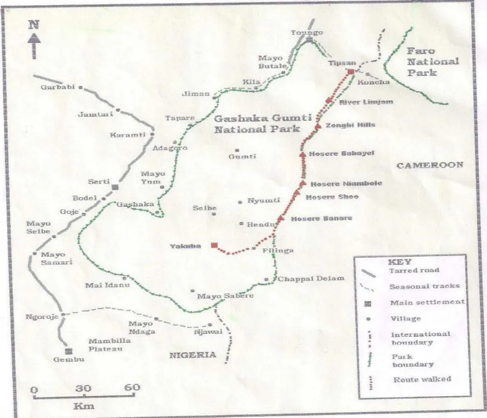
Gashaka-Gumti National Park is the largest and most diverse park in Nigeria, covering an area of approximately 6,671 Km . It's located in the northeast of Nigeria between Latitude 6 .55' and 8 .05' N, and between Longitudes 11 .11' and 12 .13' E and shares a boarder with the Republic of Cameroon in the east. (Figure 1) The parks name is derived from two of the oldest regions and most historic settlements: Gashaka village in Taraba State, and Gumti village in Adamawa State. Gashaka-Gumti National Park was created by Federal Decree (now Act) in 1991 by the merging of Gashaka Game reserve with Gumti Game Reserve (Gashaka-Gumti National Park- GGNP, 1998).
Annual rainfall within the park ranges from 1200mm in the north to 3000mm in the southern region. Wet season is normally experienced from April to November, and dry season from December to March. Lowland temperature nighttime lows in December of 10-15°C, to daytime highs in March and April, of 40°-43°C. Temperature can be much cooler at higher altitudes and during the harmattan period that occurs from November to March (GGNP, 1998).
Chapman and Chapman (2001) identified four main vegetation zones in the area as follows;.
Lowland Rainforest: occurs mainly as a gallery forest that is often found as blocks along many of the park's river valleys, gradually merging into montane forest at higher altitudes. Gallery forests are important reservoirs for biodiversity, providing both forest-edge habitats. Examples of plant species are Terminalia superba (afara), Khaya grandifoliola (savannah mahogany). Ceiba pentandra (silk cotton tree). (Chapman and Chapman, 2001).
Montane Rainforest: Much of this forest occurs as small gallery forest that is very fragile and susceptible to disturbance, especially by burning of the surrounding grasslands. Examples of some species include Khaya grandifoliola, Lovo at richiliiodes (Chapman and Chapman, 2001).
Montane Grassland: occurs at altitudes about 1,300m above sea level. This habitat has been created over time by the frequent burning of the Plateau areas. Examples of the species in this vegetation are Albizia gummifera, Schefflera abyssinica among others. (Chapman and Chapman, 2001).
Savanna Woodland: Savanna woodland dominates most of Gashaka-Gumti National Park. Two main Woodland Savanna types occur, namely Southern Guinea Savanna Woodland that occurs in the south and the Northern Guinea Savanna which dominates in the drier northern sector of the park. Such examples of savannah woodland includes Brachystegia eurycoma, Berlinia grandiflora, Pandamus candelabrum (Chapman and Chapman, 2001).
b) Study Design and Data collection
A preliminary investigation was carried out in the study area in order to assess communities, villages, population of the respondents, and occupation among others. The study design involved the assessment of the entire area based on communities and their populations in the study area. The community population was determined using information provided by National Population Commission (NPC, 2006). Cochran population allocation technique was adopted in the Households (HHs) survey from all selected village/communities as adopted by Dishan, et al. (2009). The formula is as follows:
Where:
number of questionnaire administered in each community
estimated population of the people in each community n = total number of questionnaires administered
N = total number of people in all the communities
One hundred and twenty (120) structured questionnaires were administered to the respondents while one hundred and eleven (111) was retrieved, focus group discussions were held to source information on the human settlement. In addition, direct observation of settlement and on the spot assessment of human activities in the study area was used to elicit information from the respondents in the study area. The household data was collected using a structured survey design, following a similar format to that used by Maddox (2003).
Some park management staff members and also district agricultural/natural resource management officers were consulted during the study design to facilitate the data collection on the laid down policies and the threat factor of the Park. Structured questionnaires were administered to residents and alternating male and female respondent's as much as possible and different age groups following Hill's guide (2000). In every household, the head of the household or other representatives were interviewed. The structured questionnaires were translated into local language using face to face interview on the family members.
c) Statistical Analysis of Data
The data collected was processed and analysed using descriptive statistics (Frequency Tables, means and percentages).
III. RESULTS
a) Socio-economic characteristics of the respondents in the study area
The result of socio-economic characteristics of the respondents in the study area is shown in Table 1. The result shows that 63.64%, 57.14%, 60%, 62.50% and 60% of the respondents in Mayo Sangnare, Mayo Sunsun, Toungo (AgwanSoo) Dalasum, Mayo Bakari and Mayo Bagbag respectively are males, while 36.36%, 42.86%, 40%, 41.18%, 37.50% and 40% are females. Marital status indicated 9.1%, 21.43%, 88%, 68.75%, 75% and 100% of the respondents are single, 81.8%, 78.57%, 12%, 18.75%, 25% are married. Their ages randeg from 20 to above 41 years. 57.14% and 45.45% are within the ages o 21 to 30years and 31 to 40 years respectively, with only 29.41% above 41 years.
b) Identified Human Settlement of the respondents the study area
The results on some of identified human settlements of the respondents in the study area are presented in Table 2. The results showed that 11.83, 15.05, 26.88, 18.28, 17.26 and 10.75 of the respondents settled Mayo Sangnare, Mayo Sunsun, Toungo (Agwan Soo) Dalasum, Mayo Bakari and Mayo Bag bag respectively.
c) Laid-down Policies on the respondents in the study area
The result of the laid-down policies of the regarding respondents is shown in Table 3.
The results indicated that that; prohibition on tree felling, farming inside the park, poaching, collection of non-timber forest products, grazing, roads construction and settlements formed 16.66% of the laid-down policies, where 50% of the respondents indicated that all the afore-mentioned are prohibited in the park.
d) Anthropogenic Threats/activities by the respondents in the study area
The result of some Anthropogenic Threats/activities by the respondents in the study area is shown in Table 4. The results indicated that 90.91% to 100% of the respondents agreed that there exist anthropogenic activities in the study area, while 1% to 9.09% of the respondents did not agree. The types of anthropogenic activities in the study area indicated 21.42%, 17.64%, 23.52%. 21.42% and 41.18% for poaching, grazing, family settlements, logging and collection of non-timber forest products respectively among the communities.
e) Respondents reasons for settlement in the study area
The results of respondents reasons for settlement in the study area is presented in Table 5. The result showed that 18.18% settled due to lack of forage for their livestock, 42.86% indicated lack of farming land and 30% indicate both lack of forage and farm land, while 31.25% settled for business or trading of non-timber forest products in the study area.
IV. DISCUSSIONS
a) Socio economic characteristics of the respondents in the study area
The findings on the socio-economic characteristics of the respondents observed in the study period included gender as one of the important factor in determining settlement or expansion around protected area. There was low level of formal education in the area due to poverty and probably lack of basic social amenities which are not provided by the authority concern, and is partially complimented by the National Park potentials. This also indicates that most parents do not encourage their children to attend schools. Instead, they engage in occupations that their parents are involved in, like the care of the few livestock the family owns. The findings of this study conform to that of Kideghesho et al. (2006), Hansilo and Ti ki (2017) whom reported similar findings that many rural and semi-rural parents rarely encourage their children to go school.
b) Identified Human Settlements in the study area
The finding of this study indicated that there exists some human settlements in the study area.
Collecting baseline information is a vital step in managing protected areas as observed by Kumssa and Bekele, (2008). Such information will go a long way to understand the timing, status and location of the challenges as well as the perceptions of local people towards protected areas. Like most African countries, humans also put pressure on protected areas in various ways and forms such as expansion of settlements, agricultural expansion, livestock grazing and collection of NTFPs.
c) Laid down policy on the respondents in the study area
Conservation of biodiversity in any protected area and or National Parks is done through two main approaches: one approach is the preservation approach, which aims at setting aside National Parks to exclude human activities except for tourism. Through this approach, direct use of natural resources in the park for commercial or subsistence purposes is prohibited (Adams, 2004). The finding of this study is in strong agreement with that of Adams (2004) who reported that in protecting any reserved area, there has to be an approach, often referred to as the "protectionism approach" or "the fines and fences" approach. The preservation approach aims at excluding human activities considered inimical to the objectives of conserving biodiversity in National Parks. There has to be community-based conservation approach that allows people (especially those that neighbour National Parks) to benefit socially or economically from parks (Stolton, et al., 2010). The community-based conservation approach was proposed to address the problems associated with excluding human activities from the park.
d) Anthropogenic threats/activities in the study area
The finding of this study reveals that there are various anthropogenic activities ranging from poaching, grazing/livestock raring and NTFPs collection activities that can have a wide negative impact on protected area which would eventually leads to activities such as deforestation and loss of wildlife habitat. The setrend of land uses have occupied large space that led to destructions of natural vegetation and reduced area available for wild animals. This finding conforms to that of Kideghesho, et al. (2006); Hansilo and Ti ki (2017) who also mentioned similar problems of wildlife habitats for cultivation in other African countries. Agriculture is still the backbone of Nigeria's economy as many people in the rural areas depend directly on agriculture to meet their daily demands. (Ogun tu, et al., (2012) reported that, while wildlife doesn't provide incentives directly to these people, they can't see the importance of wildlife rather than just regarding it as threats to them or their farm crops.
The increased human settlement in the area has contributed greatly to lack of free space for animal movements as it can be translated to increased human settlements as observed in the study area during this survey. This is not in contrast with that of Ndibalema (2010) who made similar report in Serengeti ecosystem. Hansilo and Tiki (2017) in Bale Mountains National Park (BMNP) also reported loss of habitats for birds due to agriculture expansions. This has also resulted in shrinkage of the buffer zone area of the park.
e) Reasons for Human Settlement in the study area
The findings on the human settlement in the study area reveals that majority of the settlers are either farmers or grazers, meaning that they have no alternative sites for such purposes. This finding is in close agreement with that of Tumusiime et al.,(2011), who reported the negative influence of settlers through Illegal livelihoods from a Protected Area in Uganda. Such activity if allowed unchecked, could have a detrimental effect on wildlife and the entire ecosystem.
V. CONCLUSION
The study viewed the influence of human settlement on wildlife conservation in Gashaka Gumti National park, Nigeria. Wildlife is under threat due to illegal human settlement, expansion of agricultural lands, poaching and livestock grazing in and around the protected area. The findings show that there are major land challenges which are associated with expansion of cropland cultivation and human settlements into areas that previously serves as wildlife habitats. These changes have negative impacts on the natural habitats of wildlife. Therefore, calls for involvement of not only conservationists, but also other stakeholders with different interests in the area and professional background, such as agriculturists, conservationists, demographers, policy makers, and land use planners to minimize the challenges. With this current trend of agriculture expansions and illegal human settlement which has already been put under cultivation of the park, the park will no longer act as a conservation area for wildlife as other protected area of the country.
Respondents Mayo Sangnare Mayo Sunsun Communities Toungo (AgwanSoo) Dalasum (Oaga) Mayo Bakari Mayo Bagbag Freq % Freq % Freq % Freq % Freq % Freq % Gender Male 7 63.64 8 57.14 15 60 10 58.82 10 62.5 6 60 Females 4 36.36 6 42.86 10 40 7 41.18 6 37.5 4 40 Total 11 100 14 100 25 100 17 100 16 100 10 100 Marital Status Single 1 9.1 3 21.43 22 88 11 68.75 12 75 10 100 Married 9 81.8 11 78.57 3 12 3 18.75 4 25 - 0 Others 1 9.1 - 0 - 0 2 12.5 - 0 - 0 Total 11 100 14 100 25 100 16 100 16 100 10 100 Age class 20yrs 2 18.2 3 21.43 3 12 1 5.88 - - 21-30yrs 4 36.36 8 57.14 11 44 7 41.18 5 31.25 5 50 31-40yrs 5 45.45 1 7.14 8 32 4 23.53 8 50 5 50 41-above - 0 2 14.29 3 12 5 29.41 3 18.75 - 0 Total 11 100 14 100 25 100 17 100 16 100 10 100 Number of children in Household 1-10 9 81.82 7 50 23 92 11 64.71 11 68.75 5 50 11-20 2 18.18 7 50 2 8 5 29.41 5 31.25 5 50 21-30 - - - 1 5.88 - - Total 11 100 14 100 25 100 17 100 16 100 10 100 Educational Status Non-Formal 5 45.45 7 50 8 32 5 29.41 4 25 4 40 Primary - 4 28.57 11 44 4 23.53 8 50 3 30 Secondary 6 54.55 3 21.4 5 20 5 29.41 4 25 3 30 Tertiary - - 1 4 3 17.65 - - Total 11 100 14 100 25 100 17 100 16 100 10 100 Settlement Respondents Frequency. Percentage (%) Mayo Sangnare 11 11.83 Mayo Sunsun 14 15.05 Toungo (AgwanSoo) 25 26.88 Dalasum (Daga) 17 18.28 Mayo Bakari 16 17.26 Mayo Bagbag 10 10.75 Total 93 100 Variables Frequency Percentage (%) Laid Down Polices of the Park Prohibition on tree felling, farming, hunting, collection of non-timber products 3 16.66 Prohibition on grazing 3 16.66 Prohibition on settlements expansions, roads construction 3 16.66 All of the above 9 50.00 Total 18 99.98 Variables Mayo Sangnare Mayo Sunsun Toungo (AgwanSoo) Dalasum (Oaga) Mayo Bakari Mayo Bagbag Freq % Freq % Freq % Freq % Freq % Freq % Respondents engagement in Anthropogenic Activities Yes 10 90.91 14 100 25 100 17 100 16 100 10 100 No 1 9.09 - 0 - 0 - 0 - 0 - 0 Total 11 100 14 100 25 100 17 100 16 100 10 100 Type of Anthropogenic Activities Poaching 2 10 3 21.42 2 8 1 5.88 1 6.25 2 20 Grazing 2 10 - 00.00 2 8 3 17.64 2 12.50 2 20 Farming 4 20 3 21.42 2 8 4 23.52 3 18.75 2 20 Logging 2 10 3 21.42 4 16 2 11.76 2 12.50 2 20 NTFPs 10 50 5 35.71 15 60 7 41.18 6 37.50 2 20 Total 20 100 14 100 25 100 17 100 16 100 10 100 Villages Number of Questionnaires Retrieved Lack of land for forage% Lack of land for farming% Both (forage and farming)% Business/Trader NTFP(s)% Mayo Sangnare 11 18.18 36.36 18.18 27.28 Mayo Sunsun 14 14.29 42.86 14.29 28.56 Toungo (AgwanSoo) 25 12 48 16 24 Dalasum (Daga) 17 17.65 41.17 17.65 23.53 Mayo Bakari 16 6.25 50 12.5 31.25 Mayo Bagbag 10 30 30 30 10 Total/Average 93 16.40 41.40 18.10 24.10