I. INTRODUCTION
The first estimates of soil losses in Brazil were analyzed in the 1940s using experimental plots at the Agronomic Institute of Campinas (BERTONI; LOMBARDI NETO, 1999).
The Universal Equation of Soil Losses was developed from the studies of Wischmeier and Smith (1961 apud LAFLEN; MOLDENHAUER, 2003) from 10,000 data on soil loss rates in experimental plots in the United States of America.
Soil losses in Brazil are estimated at approximately 848 million tons per year (MERTEN; MINELLA, 2013). Fast-paced soil losses in the degraded areas of the Western Plateau of São Paulo represent environmental and economic damage.
The scale of watersheds has repercussions in recent years due to the details of the guaranteed by advances in geographic technologies. On the local scale, the particularities of each rural producer are found and mitigating measures are applied in the face of land degradation conditions. The dialogue with rural producers takes place through the technical knowledge of public agencies and researchers guide these agencies through extension projects. The definition of the concepts and principles of water management is essential to consolidate the necessary measures in river basins. Ideals based on rational water use are important to guide political decisions and favor of soil conservation measures and recovery of degraded areas.
The geoprocessing techniques used met the research needs, confirming that its use improves the processes and phases of spatial analysis. In addition, the created database can be replicated, corrected and updated at any time, which makes it dynamic and applicable to the most diverse spatial representation demands of the information contained therein (PIROLI, 2013).
The watershed is a territorial and physical unit present in nature bounded by drainage. Nature presents its diversity and researchers need to avoid generalizing small scales and seek to understand natural phenomena in field research.
In this sense, fieldwork is necessary, as the main methodology of the geographer, to investigate the nature of each hydrographic basin and present the diagnoses (inventories), to carry out environmental planning from the perspective of water resources management with adequate prognoses to ensure the future availability of drinking potable water (GUIMARÃES, 1999).
From the development of Geographic Information Systems, spatial data from watersheds served as parameters applying the Universal Equation of Soil Losses, mainly by the formation of numerical elevation models. The development of erosive processes in the large hydrographic basins of tropical environments made it propitious to apply this empirical model in river basins to generate databases in Geographic Information Systems (PARVEEN; KUMAR, 2012).
In recent years, research on river basins and geoprocessing techniques has become more present in geographical studies. The spatiality of erosive processes involves the understanding of the aspects of hydrographic basins and the transformations that occur in rural landscapes of changes in agricultural activities. The use of conservation practices for the recovery of areas with degraded soils can contribute to the mappings performed by geographers with support in geographic information systems.
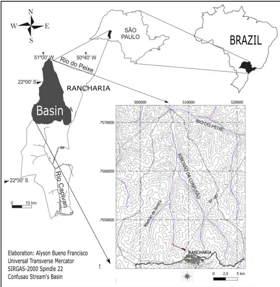
The Confusion Stream's basin has an area of 46,760 ha, located in the northwest part of the municipality of Rancharia. It is considered a sub-basin belonging to the River of Peixe basin. The channel of river of the main course is long, being the tributary Saltinho stream with an extension of 16 km. The basin has an average width of 22 km and a maximum length of 34 km. Figure 1 shows the location of the Confusion Stream's basin.
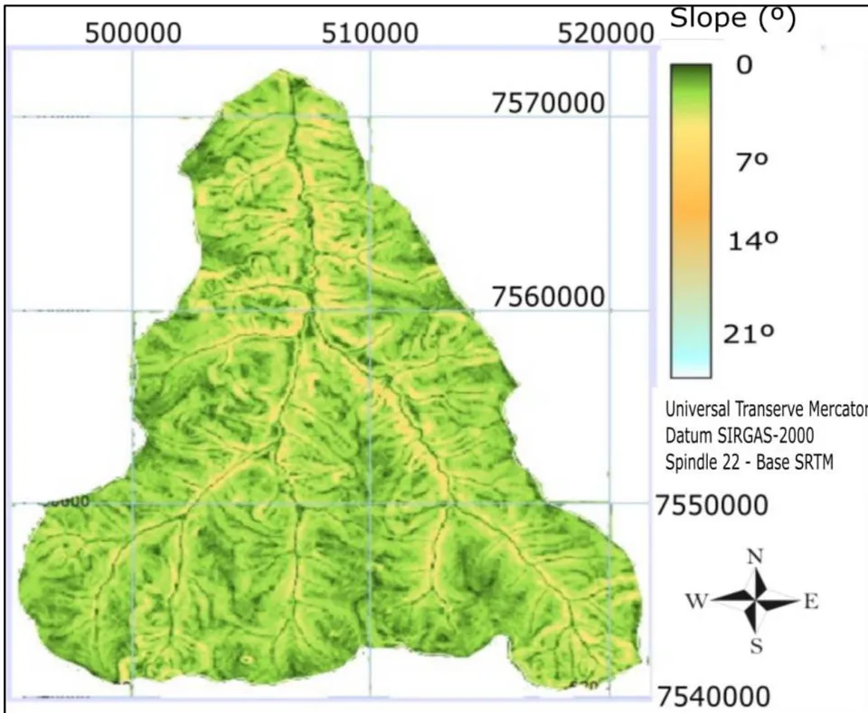
The quotas relief of the Confusion Stream's basin has between 380 and 540 meters. The relief consists of wide hills and wavy tops belonging to the Western Plateau of São Paulo. The slope is generally low between and in more than of the area, as shown in the chart in figure 2.
According to the Map of Soils in the State of São Paulo (OLIVEIRA et al., 1999), the predominant soils in the Confusion Stream's basin are the Red Latosols and the Red-Yellow Argisols. The erodibility values of the surface horizon of the Red Argisols of the Presidente Prudente region are estimated at 0.051 Mg/ha/year. For the Red Latosols of the sandy phase, the estimated values were 0.016 Mg/ha/year (FREIRE; GODOY; CARVALHO, 1992).
On the climatic conditions in the region affected by water erosion, Francisco (2017) presents the erosivity of rain for the municipality of Rancharia, considering precipitation data between 1945 and 2003, being in rainy years the R factor of 9,088 MJ.mm/ha.h.ano; 7,129 MJ.mm/ha.h.year for regular years and 5,665 MJ.mm/ha.h.year for dry years.
Despite deforestation for cotton planting until the 1970s and later the domain of pasture planting for cattle herd farming, the Confusion Stream's basin has preserved fragments of native forest (approximately of the area), including a fragment of approximately 3,000 hectares.
In the last 15 years, installing a sugar-alcohol plant in the southwestern part of the basin favored the increase of sugarcane planting areas (23% to 34% of the area) with the existence of terraced plantations, replacing the degraded pasture areas.
II. METHODOLOGY
The clinographic letter of slope was elaborated based on data from the digital elevation model from the SRTM mission, in the Slope routine of the TerrSet GIS. The slope data served as the basis for the elaboration of the estimation of the LS factor, ramp length (slopes) and unevenness (slopes).
The preparation of the land cover charts were carried out in the TerrSet Geographic Information System with orbital images of the CBERS satellite dated October 2009 and February 2018, through the supervised classification routine. The geographic referencing of the images was performed at GIS Idrisi. After geographic referencing, the false-color composition was applied with bands 2, 3 and 4.
Using the Digitize routine, reliable samples were selected with the vectorization of polygons, whose each class to be represented had a value. With the use of the Make-sig routine, signatures are created and then the classifier is defined with maximum likelihood with the use of the Max-like routine. Then, mode filtering was applied using a size 7x7. To cut out the area of the
Confusion Stream's basin, the limits of the Shuttle Radar Topography Mission (SRTM) data were delimited using SRTM data in the Global Mapper software. The vector that delimits the watershed was exported in Shapefile format, having as reference system the horizontal datum SIRGAS-2000.
Regarding the factors attributed to the Universal Equation of Soil Losses, the erodibility indexes presented by Freire et al. (1992). The rainfall erosivity (R) was estimated based on the reference of Francisco (2017) when presenting the values for an adjacent basin 15 km away from the Confusion Stream's basin. The types of soils identified in the hydrographic basin were adopted by the map presented by Oliveira et al. (1999). The C factor of soil management forms, by the land cover classes, followed the reference adopted by Pinto (1991). The factor conservation practices (P) was estimated based on the indices of calculations expressed by Bertoni and Lombardi Neto (1999).
III. RESULTS AND DISCUSSION
Table 1 presents the land cover classes in 2009 and 2018 in the Confusion Stream's basin. Table 1: Areas and plots of land cover classes in Confusion Stream's basin Figure 3 presents the land cover map of the Confusion Stream's basin by 2009 data.
| Land covers classes | Area in 2009 (ha) | % | Area in 2018 (ha) | % |
| Urban areas and roads | 0.58 | 0.01 | 1.55 | 0.003 |
| Native forest | 3,610.00 | 7.72 | 3,913.28 | 8.37 |
| Water channel | 1.42 | 0.01 | 1.58 | 0.003 |
| Agricultural crop | 10,679.00 | 22.84 | 15,768.36 | 33.72 |
| Pasture | 23,085.00 | 49.75 | 22,571.32 | 48.27 |
| Land wood | 326.00 | 0.70 | - | - |
| Bare soil | 8,698.00 | 18.75 | 3,504.06 | 09.61 |
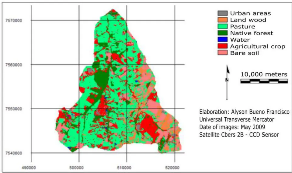
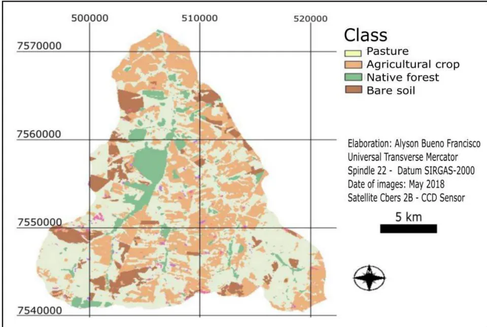
Table 2 shows the relationship between the areas of the land cover classes and the C factor of land use applied in the Universal Equation of Soil Losses.
| Land covers classes | Factor C | Area in 2009 (ha) | C (2009) | Area in 2018 (ha) | C (2018) |
| Native forest | 0.0004 | 3,610 | 0.00003 | 3,913.28 | 0.00003 |
| Agricultural crop | 0.0500 | 10,679 | 0.11420 | 15,768.36 | 0.16860 |
| Pasture | 0.0075 | 23,085 | 0.37000 | 22,571.32 | 0.36200 |
| Land wood | 0.0450 | 326 | 0.00700 | - | - |
| Bare soil | 0.1000 | 8,698 | 0.18601 | 3,504.06 | 0.00370 |
The data show factor C from 810.17 to 994.31, an increase of 18.5% in erosive potential according to land cover changes in 9 years.
The table 3 presents the relation of the areas of the land cover classes with the predominant types of soils by the K factor of erobility.
| Classe de cobertura da terra | Soil kind | Factor K | Área in 2009 (ha) | K (2009) | Área in 2018 (ha) | K (2018) |
| Native forest | Hydric soil | 0.003 | 3,610 | 0.00023 | 3,913.28 | 0.00025 |
| Agricultural crop | Clay soil | 0.051 | 10,679 | 0.01165 | 15,768.36 | 0.01719 |
| Pasture | Oxissoil | 0.016 | 23,085 | 0.00799 | 22,571.32 | 0.00772 |
| Land wood | Oxissoil | 0.016 | 326 | 0.00011 | - | - |
| Bare soil | Clay soil | 0.051 | 8,698 | 0.00949 | 3,504.06 | 0.00382 |
The erodibility factor remained practically stable in 9 years, being present the addition of native forest areas present in hydromorphic soils of primary forests and a decrease in exposed soil areas, very conducive to the development of laminar erosion.
Based on the data of the factors of application of the Universal Equation of Soil Losses by erosivity presented to the municipality of Rancharia (PERUSI et al., 2004) in 7,300 MJ.mm/ha.h.year, we have the estimated indices for the land cover classes in table 4.
| Classe de cobertura da terra | Área in 2009 (ha) | R (2009) | Área in 2018 (ha) | R (2018) |
| Native forest | 3,610 | 564.66 | 3,913.28 | 610.92 |
| Agricultural crop | 10,679 | 1,667.16 | 15,768.36 | 2,461.64 |
| Pasture | 23,085 | 3,603.94 | 22,571.32 | 3,523.7 |
| Land wood | 326 | 50.89 | - | - |
| Bare soil | 8,698 | 1,357.9 | 3,504.06 | 547.03 |
| Σ | 7,244.55 | 7,143.29 |
When considering the average length of 100 m of ramp in the basin and the mean slope of 5.67% or , the topographic factor was estimated at 0.006.
The factor of conservation practices was calculated based on the mean slope of , being obtained in 0.19342.
When considering the estimated factors of the USLE for the basin, the rates of soil losses were estimated in 2009 by the land cover classes in table 5.
| Land covers | Factor R | Factor K | Factor LS | Factor C | Factor P | Ei | A (t/ha/year) |
| Native forest | 564.66 | 0.00023 | 0.006 | 0.00003 | 0.19342 | 0.0002 | |
| Agricultural crop | 1,667.16 | 0.01165 | 0.006 | 0.11420 | 0.19342 | 0.0257 | 1,201.73 |
| Pasture | 3,603.94 | 0.00799 | 0.006 | 0.37000 | 0.19342 | 0.0123 | 577.51 |
| Bare soil | 1,357.9 | 0.00949 | 0.006 | 0.18601 | 0.19342 | 0.0027 | 130 |
| Land covers | Factor R | Factor K | Factor LS | Factor C | Factor P | Ei | A (t/ha/year) |
| Native forest | 610.92 | 0.00023 | 0.006 | 0.00003 | 0.19342 | 0.0002 | |
| Agricultural crop | 2,461.64 | 0.01165 | 0.006 | 0.11420 | 0.19342 | 0.038 | 1,777.23 |
| Pasture | 3,523.7 | 0.00799 | 0.006 | 0.37000 | 0.19342 | 0.012 | 566 |
| Bare soil | 547.03 | 0.00949 | 0.006 | 0.18601 | 0.19342 | 0.003 | 140.85 |
The Confusion Stream's basin, with 46,760 hectares, presents an estimate of soil losses at 2,484.08 t/ha/year in 2018.
IV. CONCLUSIONS
The estimates of soil losses are important for the management of watersheds with the application of mapping in the identification of the most degraded areas susceptible to erosion. The mapping of the current conditions of the hydrographic basin (inventory) favors the diagnosis of degradation conditions and proposals for environmental recovery.
Brazil is a country with large territorial extensions and watersheds that are distributed in several municipalities and states and it is important to implement policies for the management of water resources through partners with the various territorial units. Brazilian municipalities need to draw up an inventory with maps and databases of watersheds to favor water management.
Soil conservation is an interdisciplinary theme and can integrate several professionals from the technical and research fields to support public agencies in the proposals to recover areas degraded by rigorous erosive processes.
Soil degradation conditions require the improvement of more empirical scientific techniques and with the support of geographic information systems to contribute to the monitoring of erosive processes.