## I. INTRODUCTION
The Southeastern part of Kazakhstan, both geographically and historically, is known as Semirechye (or Zhetysu) due to the presence of seven major rivers. This region occupies the southern part of the Balkhash Lake basin, which is the largest in Central Asia [41; 68]. The direct area of research, where Upper Paleolithic sites are concentrated, is the foothills of the Zailiyskiy Alatau, one of the mountain ranges of the Northern Tien Shan. The northern slopes of this range are characterized by a step-like structure, consisting of two terraced levels. Almost all known archaeological sites are located on the lower terrace and are situated at altitudes ranging from 950 to 1,150 meters above sea level (Ozherelyev et al., 2023).
The Central Asian Arid Zone (CAAZ) is loosely defined as the area stretching from western Kazakhstan to eastern Mongolia (approximately $50 - 110^{\circ}\mathrm{E}$ and $35 - 50^{\circ}\mathrm{N}$ ) and is a result of the combined effects of the Siberian High in the eastern part and the Azores High in the western part. Specifically, westward extension of the Siberian High during cold seasons and eastward extension of the Azores High during warm seasons resulted in a nearly permanent high pressure ridge in the CAAZ where deserts and steppes developed (Feng et al., 2011). The cold-season climate in the CAAZ is presently controlled by the interactions between the Siberian High and the Westerlies and the latter is in turn modulated by the North Atlantic Oscillation (NAO) (Fig. 1A). Specifically, negatively-phased NAO induces the westward and southward expansion of the Siberian High, consequently lowering the winter temperature and precipitation in the downwind areas including the CAAZ (Aizen et al., 2001; Meeker and Mayewski, 2002). The warm season climate in the CAAZ is presently controlled by the interactions between the Asian Low occupying the interiors of Asia and the Azores High reaching the CAAZ (Fig. 1B). Frequent invasion of the polar front is the major mechanism for generating precipitation in the CAAZ (Li, 1991; Lydolph, 1977).
Minerogenic aerosols (or dust) originating in the CAAZ deserts and steppes are entrained into the atmosphere mostly via dust storms under strong wind conditions (Indoitu et al., 2009). They were primarily transported over a long distance to have deposited as pelagic mud in North Pacific (Rea and Hovan, 1995) and also over a short distance to have deposited as loess on the forelands of mountains (Dodonov et al. 2006). The forelands of the Tianshan Mountain chair (see Fig. 1c and Fig. 1d for topographic backgrounds) are the most significant ones in terms of loess distribution in the
CAAZ (Dodonov and Baiguzina, 1995; Feng et al., 2011). The distribution of CAAZ loess deposits between the well-studied European loess sequences to the west and the extensive Chinese loess plateau region to the east enables researchers to carry out inter-regional paleoclimatic investigations along a west-east transect across the entire Eurasian loess belt of the Northern Hemisphere (Ding et al., 2002; Fitzsimmons et al., 2018; Machalett et al., 2008).
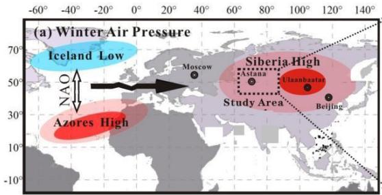
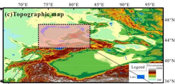
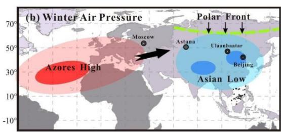
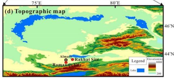 Figure 1: Climatic settings and topographic backgrounds. a: winter air pressure situation in the Eurasian continent; b: summer air pressure situation in the Eurasian continent; c: topographic background of the Central Asian Arid Zone (CAAZ); d: topographic background of the southeastern Kazakhstan (i.e., the focal area of this study).
A recent study on a late Pleistocene loess sequence (i.e., Remisowka site) in Almaty within the southeastern Kazakhstan (Machalett et al., 2008) suggests that besides the prevailing Westerlies and the Siberian High, the polar front activity is another main force of aeolian dust generation and transportation in the CAAZ. They concluded that a steeper (gentler) meridional pressure contrast between southern tropical air and polar air masses, plus the lack (abundance) of moisture during glacials (interglacials), lead to a longer (shorter) seasonal duration, permanency and strength of the polar front on its southern winter position (seasonal domination), involving increased (decreased) and stronger (weaker) cyclonic activity and thus more (less) aeolian transport on orbital timescales. Our recent work (Ran et al., 2020) at a nearby site (Romantic site; also named as Maibulak site in Fitzsimmons et al., 2017) shows that the wind intensity might be indeed stronger during the last glacial than during the recent interglacial (i.e., Holocene). However, our recent work (Ran et al., 2020) also tells a dramatically different suborbital-scale story. That is, the major weak wind-intensity events were chronologically corresponding with the Heinrich (rather cold) Events in the North Atlantic region. The suborbital-scale corresponding relationship might be associated with slowdown or shutdown of the Thermohaline Deep Water Circulation during the Heinrich (rather cold) Events when the Northern Hemisphere was thus drastically cooled. It implies that the southeastern Kazakhstan was most likely in the core of the expanded
Siberian High under the drastically cooled conditions and that the resulted low air pressure gradient in the core failed to promote dust storm activities during the Heinrich Events.
The Central Asian Arid Zone (CAAZ) has been reported to have delivered some of the most significant archaeological discoveries in recent decades. Especially, new genetic data indicate that at least two archaic human species (i.e., Neandertals and Denisovans) shared the territories within the CAAZ and possibly interbred with anatomically modern humans as they arrived in the Altai Mountain within the core of CAAZ (Fitzsimmons et al., 2017). They suggested that there was a trend towards increasing occupation of open air sites across the Tianshan piedmont after $\sim 40$ ka (ka = thousand years before present), corresponding to more humid climatic conditions including pulses of more intensive dust deposition. They continued to suggest that human occupation persisted into the cold and dry Last Glacial Maximum. But, they seriously cautioned that a need is pressing to develop a much better defined database before making any causal connections between the occupation timings and the palaeo-climatic conditions.
This contribution provides a high-resolution wind-intensity dataset covering the past 50,000 years from the Romantic site near Almaty (Ran et al., 2020) with an attempt to put the reported culture layers from the same site (Fitzsimmons et al., 2017) into a wind-related environmental context. This contribution also tries to put the reported culture layers from Rakhat site (Necklace et al., 2019) into our recently-obtained palaeo-climatic framework. Again, we (the authors of this contribution) echo the caution by Fitzsimmons et al. (2017) that a need is pressing to develop a much better defined database before making any causal connections between the occupation timings and the palaeo-climatic conditions.
We should also mention that the effects of geographical factors, which are indirectly related to our study and constitute an independent field of research, on various phenomena related to social structure, human relations and personality formation, have been extensively examined in the literature (Ar1, 1999: 219).
## II. LITERATURE REVIEW
The present study investigates the interactions between environmental changes and human societies during the Late Pleistocene and Holocene periods in the Semirechye region of southeastern Kazakhstan. This paper examines loess-paleosol sequences from the Romantic (Maibulak) and Rakhat sites, located in the foothills of the Zailyskiy Alatau (Northern Tien Shan). Climatic Dynamics Wind Activity (based on loess grain-size analysis): Four distinct phases of wind intensity variation over the past $\sim 50$ kyr were identified, linked to fluctuations in Northern Hemisphere summer insolation (Berger & Loutre, 1991). Increased wind intensity has been observed to correlate with low insolation periods (e.g., Stages 1 and 3), a phenomenon attributed to the influence of the Siberian High (Ran et al., 2020). Temperature and Moisture (based on brGDGT and $\delta 13C$ proxies): The brGDGT-based reconstructions demonstrate congruence with global climatic trends: cold phases during MIS 2 and MIS 4, moderate conditions in MIS 3, and warming in MIS 1 (De Jonge et al., 2014). Conversely, the $\delta 13C$ data indicates aridity during the Last Glacial Period (MIS 4-MIS 2) and increased humidity in the Holocene (Ran & Feng, 2014). Cultural Adaptations Archaeological layers at the Romantic (CH1-CH3) and Rakhat (CH1-CH8) sites demonstrate discontinuous human occupation, yet no direct correlation with wind intensity variations is apparent (Fitzsimmons et al., 2017). The most favourable conditions for human habitation occurred during MIS 3 and MIS 4, whereas MIS 2 (Last Glacial Maximum) likely rendered the region less hospitable (Necklace et al., 2019). Key Findings: The region's climatic changes were driven by global factors (insolation, Siberian High). The presence of cultural layers does not always coincide with extreme climatic events, underscoring the necessity for higher-resolution studies. Southeastern Kazakhstan was identified as a potential habitation zone during cold phases, albeit with fluctuating occupation intensity. Future Directions: The authors emphasise the necessity for refined chronologies and expanded datasets to establish causal links between climate and cultural dynamics (Fitzsimmons et al., 2017).
Primary References: Feng et al. (2011) – Stratigraphy of Central Asian loess. Fitzsimmons et al. (2017) – Upper Paleolithic chronology. Additionally, Ran et al. (2020) provide a reconstruction of wind intensity. Necklace et al. (2019) – Archaeology of the Rakhat site. The present review employs an interdisciplinary approach, integrating geological, paleoclimatic, and archaeological methods to study human adaptation in a changing environment.
## III. MATERIALS AND METHODS
This study employs a multi-disciplinary approach to reconstruct past climatic conditions in southeastern Kazakhstan, focusing on two loess sequences from the Romantic and Rakhat sites. To understand the regional wind intensity variations, grain size analysis was conducted, and a wind-intensity index based on the ratio of coarse silt $(20 - 61\mu \mathrm{m})$ to fine silt and clay fractions $(< 20\mu \mathrm{m})$ was adopted from Antoine et al. (2013). Chronological data for both sites were obtained through radiocarbon dating of organic materials (charcoal and snails) and optically stimulated luminescence (OSL) dating of quartz and polymineral samples, following the procedures described in Feng et al. (2011) and Fitzsimmons et al. (2018). Bayesian age-depth modeling was applied to construct a robust temporal framework for the loess sequences.
For the Rakhat site, paleoclimate reconstructions were enhanced by analyzing branched glycerol dialkyl glycerol tetraethers (brGDGTs) to estimate mean annual air temperature (MAAT) using transfer functions (De Jong et al., 2014). Carbon isotope (δ13Corg) analysis was utilized to infer moisture variations, as C3 plants dominated the local vegetation. The temperature and moisture data were compared with summer insolation curves (Berger and Loutre, 1991) to assess the climatic shifts over the past 50,000 years. Statistical analyses, including cubic spline interpolation and Bayesian methods, were employed to create the age-depth models for both sites, allowing for a detailed reconstruction of environmental conditions and their potential influence on human occupation in the region.
## IV. RESULTS
### a) Wind Intensity Sequence at the Romantic Site
The pedostratigraphy and chronology of the Romantic loess sequence, previously outlined by Feng et al. (2011), have been further refined through recent radiocarbon and luminescence dating efforts. The loess-paleosol sequence consists of six distinct units, including mollisol-like paleosols, massive yellowish loess, gleyed loess, and entisol-like palessols, spanning an age range from $\sim 50,000$ to $\sim 10,000$ years BP. The integration of charcoal and snail-based radiocarbon dating, along with polymineral pIR-IRSL290 luminescence dates (Fitzsimmons et al., 2018), enables the construction of an age-depth model, revealing a detailed chronological framework for this sequence (Fig. 2).
The grain size-based wind intensity index, following the methodology of Antoine et al. (2013), was employed to reconstruct past wind dynamics. The index, derived from the coarse silt to fine silt/clay ratio, reflects four distinct stages of wind intensity variability during the last $\sim 50,000$ years. These stages are marked by significant shifts in atmospheric circulation, with wind intensity peaking during $\sim 50,000 - 41,000$ BP (Stage 1) and $\sim 33,000 - 23,000$ BP (Stage 3), coinciding with low summer insolation periods. In contrast, wind intensity significantly decreased during periods of increasing insolation, such as $\sim 41,000 - 33,000$ BP (Stage 2) and $\sim 23,000 - 10,000$ BP (Stage 4), aligning with a weakening of the Siberian High. These results suggest that shifts in insolation-driven atmospheric dynamics governed regional wind intensity patterns, with implications for dust storm frequency and intensity.
Notably, the cultural occupations at the Romantic site (CH1-CH3) do not appear to have been directly influenced by variations in wind intensity. CH3 (36,600-43,400 cal. BP) occurred during a high wind intensity phase, CH2 (29,000-34,700 cal. BP) during a low intensity period, and CH1 (15,000-21,500 cal. BP) during a time of declining wind intensity. These findings suggest that human occupation may have been independent of loess-recorded wind intensity, although the human groups seemingly avoided the coldest phase of the Last Glacial Maximum (~25,000-20,000 cal. BP).
## i. Temperature and Moisture Variations at the Rakhat Site
The pedostratigraphy and chronology of the Rakhat site, as defined by Necklace et al. (2019), consists of nine stratigraphic units, including well-developed Mollisols, sandy loess, silty loess, and gravel layers. Cultural layers were identified within several of these units, with ages derived from radiocarbon and OSL dating, resulting in an age-depth model suggesting the presence of human occupations over the past $\sim 70,000$ years (Fig. 4).
To reconstruct past climatic conditions, the brGDGT-based Mean Annual Air Temperature (MAAT) and $\delta 13\mathrm{Corg}$ -based moisture proxies were applied to the Rakhat sequence. The brGDGT-based MAAT reconstruction reveals a clear correspondence with Northern Hemisphere summer insolation, reflecting a warm Marine Isotope Stage 1 (MIS 1, $\sim 10,000$ years BP), a cold MIS 2 ( $\sim 25,000 - 10,000$ years BP), and a moderate MIS 3 ( $\sim 57,000 - 25,000$ years BP). Notably, the temperature pattern during MIS 4 ( $\sim 73,000 - 57,000$
years BP) suggests another cold phase, consistent with global climatic trends (Fig. 5A).
The δ13Corg data, indicative of soil moisture variations, suggest that the Last Glacial period (encompassing MIS 2, MIS 3, and MIS 4) was marked by relatively dry conditions, while the Holocene (MIS 1) was wetter (Fig. 5B). These findings support the hypothesis that southeastern Kazakhstan provided suitable conditions for human habitation during MIS 4 and MIS 3, with relatively favorable climatic conditions, but was less conducive to human settlement during the cold and dry MIS 2.
Together, these results provide new insights into the relationship between climate, environmental change, and human occupation in southeastern Kazakhstan, underscoring the complex interplay between atmospheric circulation, temperature, moisture, and the survival strategies of early human populations in the region.
The effects of geographical factors, which are indirectly related to our study and constitute an independent field of research, on various phenomena related to political science such as social structure, human relations and political attitudes are widely examined in the literature (Arí, 1999: 219). For example, communities living on the seashore and those living inland or those living in fertile lands and those living in arid regions develop different lifestyles and social structures due to their different socio-economic conditions. This has led many thinkers since Ancient Greece to analyze socio-cultural and political phenomena through geographical factors (Sorokin, 1994: 102). In the historical process, thinkers such as Aristotle, Ibn Khaldun and Montesquieu have systematically addressed various social and political problems from the perspective of geographical determinism (Kislali, 1987: 28).
## V. DISCUSSION
### a) Wind Intensity Sequence at Romantic Site
## i. Pedostratigraphy and Chronology
We have already reported the pedostratigraphy and chronology (Feng et al., 2011). In brief, the loess-paleosol sequence can be divided into six pedostratigraphic units (Fig. 2A). Unit 1 (0-150 cm) is a mollisol-like paleosol. Unit 2 (150-300 cm) is a massive and yellowish loess unit. Unit 3 (300-400) is a gleyed loess unit. Unit 4 (400-450 cm) is again a massive and yellowish loess unit. Unit 5 (450-700 cm) is an entisollike paessol. Unit 6 (700-800 cm) is a massive and yellowish loess unit. We obtained six (6) radiocarbon dates on snails and charcoals (Feng et al., 2011). Recently, Fitzsimmons et al. (2018) further studied the middle part (i.e., 2 to 6 m) of Romantic loess section (referred as Maibulak in their papers) and obtained two sets of luminescence dates at exactly the same depths: one set based on quartz OSL dating and another set based on polymineral pIR-IRSL $_{290}$. The authors (Fitzsimmons et al., 2018) preferred the polymineral pIR-IRSL $_{290}$ dates over the quartz OSL dates. Figure 2A shows that our charcoal dates, which were corroborated by co-existing archaeological artifacts, are in a rather good agreement with the polymineral pIR-IRSL $_{290}$ dates.
Consequently, we adopted the snail- and charcoal-based dates and the polymineral pIR-IRSL $_{290}$ dates to establish the age-depth model of Romantic loess section using a cubic spline interpolator with Bayesian statistical methods (Fig. 2B). According to the model, the Romantic loess section was formed between $\sim 50,000$ yr BP and $\sim 10,000$ yr BP.
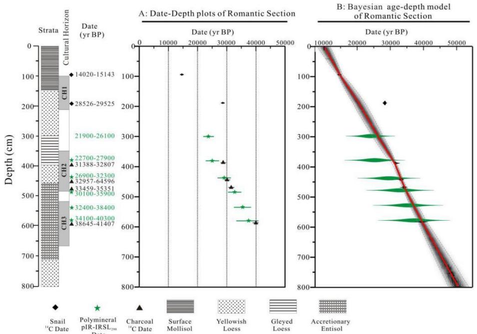 Figure 2: Strata, dates and age model of the Romantic loess section: A: Date-depth plots; B: Bayesian age-depth model (adopted from Ran et al., 2020).
## ii. Wind Intensity Sequence
To reconstruct the past changes in wind dynamics and in atmospheric circulation, grain size-based wind intensity indices have been adopted by several research teams. Our study employed the index presented by Antoine et al. (2013). The index was defined as the percentage ratio $\square \square \square \square \square \square \square \square \mathrm{m}$ $\square \square \square \square \square \square \square \mathrm{m}$ of coarse silt fraction (20-61 m) over fine silt and clay fractions (\<20 m). As shown in Figure 3, both the sand percentage (Fig. 3A) and the wind-intensity index (Fig. 3B) exhibit four stages of variations during the data-covering period from $\sim 50,000$ yr BP to $\sim 10,000$ yr BP. Stage 1 (from $\sim 50,000$ to $\sim 41,000$ yr BP) was the first wind-intensity increasing period and Stage 2 (from $\sim 41,000$ to $\sim 33,000$ yr BP) was an extremely low wind-intensity period. Stage 3 (from $\sim 33,000$ to $\sim 23,000$ yr BP) was the second wind-intensity increasing period and Stage 4 (from $\sim 23,000$ to $\sim 10,000$ yr BP) was a wind-intensity decreasing period.
We compared the wind intensity in the southeastern Kazakhstan (Ran et al., 2020) with the summer insolation in the Northern Hemisphere (Berger and Loutre, 1991). Our comparison shows that wind intensity variations were generally corresponding with the summer insolation variations. Specifically, the wind-intensity increasing stages (i.e., Stages 1 and 3) were concurrent with the summer insolation decreasing periods. And, the extremely low wind-intensity stage (i.e., Stage 2) and the wind-intensity decreasing stage (i.e., Stage 4) were concurrent with the summer insolation increasing periods. The corresponding relationships can be explained by the insolation-controlled dynamics of the Siberian High. That is, the Siberian High might have become stronger or the duration of the Siberian High-related winter-monsoon domination might have become longer when the summer insolation was decreasing, resulting in more intensive dust storms. In contrast, the Siberian High might have become weaker or the duration of the Siberian High-related winter-monsoon domination might have become shorter when the summer insolation was increasing, resulting in less intensive dust storms (Ran et al., 2020).
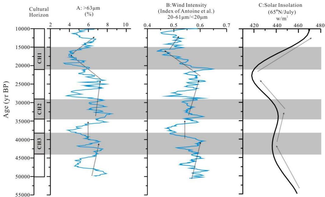 Figure 3: Grain size-based wind intensity index curve of Romantic loess-paleosol sequence (Ran et al., 2020) and the comparison with the summer insolation in the Northern Hemisphere (Berger and Loutre, 1991). A: Sand percentage ( $>63\text{m}$ ); B: Wind intensity index; C: Summer insolation in the Northern Hemisphere.
Here, we try to put the reported culture layers (Fitzsimmons et al., 2017) into a wind-related environmental context (Ran et al., 2020). The depths of the three cultural layers at the Romantic site are approximately $1.0\sim 2.1\mathrm{m}$ (CH1), $3.5\sim 4.8\mathrm{m}$ (CH2), and $5.2\sim 6.6\mathrm{m}$ (CH3). And, the ages of the three cultural layers are approximately $15,000\sim 21,500$ cal. yr BP (CH1), $29,000\sim 34,700$ cal. yr BP (CH2), and $36,600\sim 43,400$ cal. yr BP (CH3). Our comparison of the wind intensity chronology with the ages of the three cultural layers shows that the cultural occupations might have not affected by loess-recorded wind intensity. That is, CH3 $(36,600\sim 43,400$ cal. yr BP) occurred during a period of a high wind intensity; CH2 $(29,000\sim 34,700$ cal. yr BP) during a period of a relatively low wind intensity; CH1 $(15,000\sim 21,500$ cal. yr BP) during a period of a dramatically declining wind intensity. However, the human occupation seemed to have avoided the coldest Last Glacial Maximum lasting from approximately 25,000 to 20,000 cal. yr BP, as indicated by the summer insolation in the Northern Hemisphere (Berger and Loutre, 1991).
### b) Temperature and Moisture Variations at Rakhat Site
## i. Pedostratigraphy and Chronology
The loess-paleosol sequence from Rakhat site (Necklace et al., 2019) was pedostratigraphically divided into nine units (Fig. 4A) that were further confirmed in 2019 by one of the authors of this contribution (i.e., Z.-D. Feng). Unit 1 $(0\sim 2\mathrm{m})$: a well-developed Mollisol with a rather visible B horizon; Unit 2 $(\sim 2\sim 4\mathrm{m})$: a light brown, loose, sandy loess layer; Unit 3 $(\sim 4\sim 8\mathrm{m})$:
a dark gray, loose, silty loess layer containing three cultural layers (1, 2, 3); Unit 4 ( $\sim$ 8- $\sim$ 9.5 m): a dark brown, loose, silty loess layer; Unit 5 ( $\sim$ 9.5- $\sim$ 10.5 m): a light brown, loose, sandy loess layer containing a cultural layer (4); Unit 6 ( $\sim$ 10.5- $\sim$ 11.8 m): a sandy clay layer containing small gravels and containing three cultural layers (5, 6, 7); Unit 7 ( $\sim$ 11.8- $\sim$ 12.3 m): a silty clay layer containing more gravels and containing a cultural layer (8); and Unit 8 ( $12.3- \sim 13\mathrm{m}$ ): a gravel layer.
Only one charcoal-based radiocarbon date was given in Necklace et al. (2019) and four quartz-based OSL dates were recently obtained (Ran, unpublished dates). We adopted these five dates to establish the age-depth model of Rakhat loess section using a cubic spline interpolator with Bayesian statistical methods (Fig. 4B). If (only if) the age-depth model, based on these five dates, is somewhat acceptable, the Rakhat loess section covers the soil-forming and dust-depositing histories of the past 70,000 years. Again, if (only if) the age-depth model, based on these five dates, is somewhat acceptable, the observed eight cultural layers (CH1~CH8) seemed to have occurred at the following ages (see Fig. 4B): CH1 (~6.6 m) at ~40,500 yr BP; CH2 (~6.8 m) at ~41,500 yr BP; CH3 (~7.0 m) at ~42,900 yr BP; CH4 (~10.0 m) at ~58,600 yr BP; CH5 (~10.8 m) at ~62,600 yr BP; CH6 (~11.2 m) at ~64,700 yr BP; CH7 (~11.6 m) at ~66,700 yr BP; and CH8 (~11.9 m) at ~68,200 yr BP.
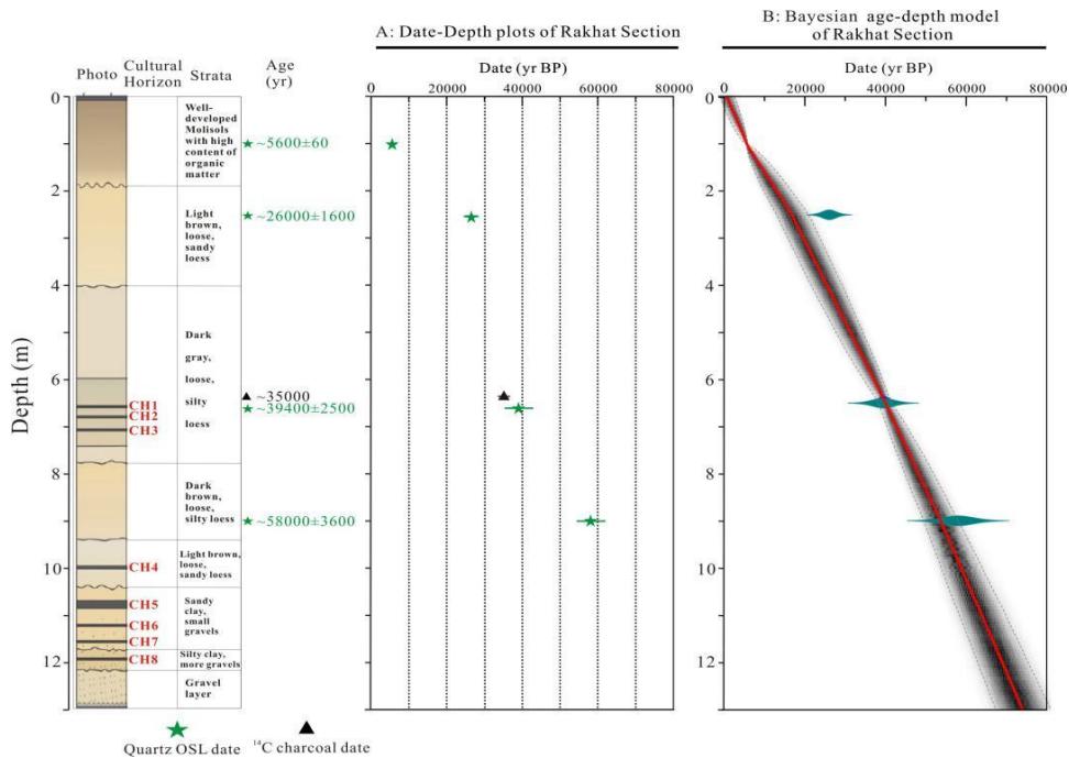 Figure 4: Strata, dates and age model of the Rakhat loess section: A: Date-depth plots; B: Bayesian age-depth model.
## ii. Temperature and Moisture Variations
Branched glycerol dialkyl glycerol tetraether (brGDGTs) membrane lipids have been widely used to reconstruct past climate and environmental change from natural archives, including loess (Peterse et al., 2012), peat bogs (Zheng et al., 2015), lakes (Sinninghe Damsté et al., 2009; Tierney et al., 2012), and rivers and estuaries (Kim et al., 2010, 2012; Zhu et al., 2011). Specifically, the existing studies on the relationship between brGDGTs in modern soils and modern environmental parameters (i.e., soil pH and atmospheric temperature) show that the variations in the cyclisation of brGDGTs (CBT-index) in soils correlates with soil pH and that the methylation index of brGDGTs (MBT) correlates with both soil pH and mean annual air temperature (MAAT) (Weijers et al., 2007; Peterse et al., 2012; De Jonge et al., 2014). Furthermore, these correlations were quantified by establishing transfer functions between soil brGDGT-based CBT and soil pH and also transfer functions between soil brGDGT-based MBT and atmospheric temperature. Here we applied the newest transfer function built by De Jong et al. (2014) to quantitatively reconstruct the atmospheric temperature variation in Rakhat section during the past 50,000 yr BP (Fig. 5A).
Terrestrial higher plants mainly utilize two principal photosynthetic pathways to fix carbon, i.e., Calvin-Benson $(C_{3}$ plants) and Hatch-Slack $(C_{4}$ plants) pathways. $C_{3}$ plants generally have $\square \square C$ values in the range of $-22\%$ to $-34\%$. with an average of $-27\%$. $C_{4}$ plants generally have $\delta^{13}C_{org}$ values in the range of $-10\%$ to $-16\%$. with an average of $-13\%$. (Deines, 1980; O'Leary, 1988; Farquhar et al., 1989). It has been well documented that temperature is positively correlated with plant isotopic signatures in $C_4$ dominated ecosystems (i.e., higher temperature, more positive isotopic signatures) (Teeri et al., 1980; Sage et al., 1999; Lorens et al., 2004; Nordt et al., 2007) and precipitation is negatively correlated with plant isotopic signatures in $C_3$ dominated ecosystems (i.e., more precipitation, more negative isotopic signatures) (Stewart et al., 1995; Bowling et al., 2002; Fessenden and Ehleringer, 2003; Lu et al., 2004). The existing investigations on the relationship between modern soil organic carbon isotopes and vegetation type abundantly demonstrated that when the abundance of $C_3$ plants is $100\%$, soil $\delta^{13}C_{org}$ is $\leq -24\%$ and when the abundance of $C_4$ plants is above $80\%$, soil $\delta^{13}C_{org}$ is $\geq 16\%$ (Tieszen et al., 1997; Bird and Pousai, 1997). As shown in Fig. 5B, almost all the $\delta^{13}C_{org}$ values are $\leq -24\%$ in Rakhat section, which means that the $C_3$ plants have been the predominant plants around the Rakhat site. Therefore, the $\delta^{13}C_{org}$ in Rakhat section can be used as an indicator of precipitation or soil moisture (Ran and Feng, 2014; Wang et al., 2019).
The brGDGT-based MAAT (mean annual air temperature) and $\delta^{13}\mathrm{C}_{\mathrm{org}}$ -based moisture variations in Rakhat section during the past 50,000 yr BP are shown in Figure 5. Although the data resolution is rather low (only 12 data points), our reconstruction roughly outlines the climate change in the southeastern Kazakhstan during the past 50,000 years with a high credibility. Specifically, the brGDGT-based MAAT variations indicated a warm MIS1 (Marine Isotope Stage 1 spanning over the past $\sim 10,000\mathrm{m}$ years), a cold MIS2 ranging from approximately 25,000 to 10,000 years BP
(BP: before the present) and a moderate MIS3 ranging from approximately 57,000 to 25,000 years BP (Fig. 5A). The brGDGT-based MAAT variations seem to have well responded to the summer insolation variations in the northern hemisphere (Fig. 5C). If the summer solar radiation indeed controls the temperature in southeastern Kazakhstan, the climate during MIS4 ranging from approximately 73,000 to 57,000 years BP should be another cold period. The $\delta^{13}\mathrm{C}_{\mathrm{org}}$ -based moisture variations suggest that the entire Last Glaciation (i.e., MIS2, MIS3 and MIS4) was relatively dry and the recent interglacial (i.e., MIS 1 or Holocene) was relatively wet (Fig. 5B).
Again, if (only if) the age-depth model, based on these five dates, is somewhat acceptable, it seemed that the southeastern Kazakhstan was suitable for human habitation during MIS4 (CH8-CH5) and MIS3 (CH4-CH1), but not during MIS2.
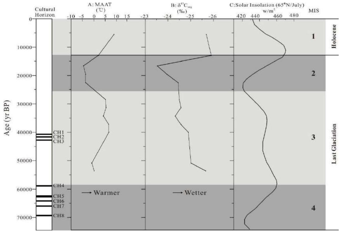 Figure 5: brGDGT-based temperature variations (A) and $^{13}\mathrm{C}$ -based moisture variations (B) of Rakhat loess-paleosol sequence (Ran, unpublished data) and the comparison with the summer insolation in the Northern Hemipshere (Berger and Loutre, 1991).
## VI. CONCLUSIONS
Three conclusions can be drawn from this contribution. First, our comparison of the wind intensity chronology with the ages of the three cultural layers from Romantic site shows that the cultural occupations might have not affected by loess-recorded wind intensity. For example, CH3 occurred during a period of a high wind intensity; CH2 during a period of a relatively low wind intensity; and CH1 during a period of a dramatically declining wind intensity. Second, although the data resolution from Rakhat site is rather low (only 12 data points), our reconstruction roughly outlines the climate change in the southeastern Kazakhstan during the past 50,000 years with a high credibility. The brGDGT-based MAAT variations from Rakhat site seem to have well responded to the summer insolation variations in the northern hemisphere. That is, the brGDGT-based MAAT variations indicated a warm MIS1, a cold MIS2 and a moderate MIS3. And, the $^{13}\mathrm{C}$ -based moisture variations from the same site display a relatively dry Last Glaciation (MIS 1, MIS2 and MIS3) and a relatively wet Recent Interglacial (i.e., MIS 1 or Holocene). Third, it seemed that the southeastern Kazakhstan was suitable for human habitation during MIS4 (spanning from 73,000 to 57,000 years BP) and MIS3 (spanning from 57,000 to 25,000 years BP), but not during the coldest MIS2 (spanning from 25,000 to 10,000 years BP).
Finally, we (the authors of this contribution) want to echo the caution by Fitzsimmons et al. (2017) that a need is pressing to develop a much better defined database before making any causal connections between the occupation timings and the palaeo-climatic conditions.
### ACKNOWLEDGMENTS
This research was supported by two Chinese grants (NSFC No. 41502168 and NSFC No. 41771234) and two Kazakhstan grants (1 History and Culture of the Great Steppe (BR05233709); 2 Study of the Possibility of Applying the Methods of Natural Sciences to Archaeological Research).
Generating HTML Viewer...
References
44 Cites in Article
Elena Aizen,Vladimir Aizen,John Melack,Tsutomu Nakamura,Takeshi Ohta (2001). Precipitation and atmospheric circulation patterns at mid‐latitudes of Asia.
P Antoine,D Rousseau,J Degeai,O Moine,F Lagroix,S Kreutzer,M Fuchs,C Hatté,C Gauthier,J Svoboda,L Lisá (2013). Highresolution record of the environmental response to climatic variations during the Last Interglacial-Glacial cycle in Central Europe: The loess-palaeosol sequence of Dolní Věstonice (Czech Republic).
T Arı (1999). International relations [Uluslararası ilişkiler.
A Berger,M Loutre (1991). Insolation values for the climate of the last 10 million years.
M Bird,P Pousai (1997). Variation of δ¹³C in the surface soil organic carbon pool.
D Bowling,N Mcdowell,J Bond,B Law,J Ehleringer (2002). δ¹³C content of ecosystem respiration is linked to precipitation and vapor pressure deficit.
Cindy De Jonge,Ellen Hopmans,Claudia Zell,Jung-Hyun Kim,Stefan Schouten,Jaap Sinninghe Damsté (2014). Occurrence and abundance of 6-methyl branched glycerol dialkyl glycerol tetraethers in soils: Implications for palaeoclimate reconstruction.
Peter Deines (1980). THE ISOTOPIC COMPOSITION OF REDUCED ORGANIC CARBON.
Z Ding,V Ranov,S Yang,A Finaev,J Han,G Wang (2002). The loess record in southern Tajikistan and correlation with Chinese loess.
A Dodonov,L Baiguzina (1995). Loess stratigraphy of Central Asia: Palaeoclimatic and palaeoenvironmental aspects.
A Dodonov,T Sadchikova,S Sedov,A Simakova,L Zhou (2006). Multidisciplinary approach for paleoenvironmental reconstruction in loess-paleosol studies of the Darai Kalon section, Southern Tajikistan.
G Farquhar,J Ehleringer,K Hubick (1989). Carbon Isotope Discrimination and Photosynthesis.
Z Feng,M Ran,Q Yang,X Zhai,W Wang,X Zhang,C Huang (2011). Stratigraphies and chronologies of late Quaternary loess-paleosol sequences in the core area of the Central Asian arid zone.
J Fessenden,J Ehleringer (2003). Temporal variation in δ¹³C of ecosystem respiration in the Pacific Northwest: Link to moisture stress.
K Fitzsimmons,R Iovita,T Sprafke,M Glantz,S Talamo,K Horton,T Beeton,S Alipova,G Bekseitov,Y Ospanov,J.-M Deom,R Sala,Z Taimagambetov (2017). A chronological framework connecting the early Upper Palaeolithic across the Central Asian piedmont.
K Fitzsimmons,T Sprafke,C Zielhofer,C Günter,J.-M Deom,R Sala,R Iovita (2018). Loess accumulation in the Tian Shan Piedmont: Implications for palaeoenvironmental change in arid Central Asia.
R Indoitu,L Orlovsky,N Orlovsky (2009). Dust storms in Middle Asia: spatial and temporal variations.
J-H Kim,B Zarzycka,R Buscail,F Peterse,J Bonnin,W Ludwig,S Schouten,J Sinninghe Damsté (2010). Contribution of river‐borne soil organic carbon to the Gulf of Lions (NW Mediterranean).
Jung-Hyun Kim,Claudia Zell,Patricia Moreira-Turcq,Marcela Pérez,Gwenaël Abril,Jean-Michel Mortillaro,Johan Weijers,Tarik Meziane,Jaap Sinninghe Damsté (2012). Tracing soil organic carbon in the lower Amazon River and its tributaries using GDGT distributions and bulk organic matter properties.
A Kışlalı (1987). Political science [Siyaset bilimi.
J Li (1991). Climate and weather in Xinjiang.
Laura Llorens,Josep Pe�uelas,Claus Beier,Bridget Emmett,Marc Estiarte,Albert Tietema (2004). Effects of an Experimental Increase of Temperature and Drought on the Photosynthetic Performance of Two Ericaceous Shrub Species Along a North?South European Gradient.
H Lu,N Wu,Z Gu,Z Guo,W Luo,H Wu,G Wang,L Zhou,J Han,T Liu (2004). Distribution of carbon isotope composition of modern soils in the Qinghai-Tibetan Plateau.
P Lydolph (1977). Climates of the Soviet Union.
Björn Machalett,Eric Oches,Manfred Frechen,Ludwig Zöller,Ulrich Hambach,Nadira Mavlyanova,Slobodan Marković,Wilfried Endlicher (2008). Aeolian dust dynamics in central Asia during the Pleistocene: Driven by the long‐term migration, seasonality, and permanency of the Asiatic polar front.
L Meeker,P Mayewski (2002). A 1400year high-resolution record of atmospheric circulation over the North Atlantic and Asia.
D Necklace,E Jaserbayev,T Mamryov (2019). Stratigraphic and cultural characteristics of southeastern Kazakhstan since Upper Paleolithic.
L Nordt,J Fischer,L Tieszen,J Tubbs (2007). Coherent changes in relative C4 plant productivity and climate during the late Quaternary in the North American Great Plains.
Marion O'leary (1988). Carbon Isotopes in Photosynthesis.
D Ozherelyev,T Mamirov (2023). A Complex of Stratifi ed Upper Paleolithic Sites in the Foothills of the Northern Tien Shan: General Data and Research Perspectives.
Francien Peterse,Jaap Van Der Meer,Stefan Schouten,Johan Weijers,Noah Fierer,Robert Jackson,Jung-Hyun Kim,Jaap Sinninghe Damsté (2012). Revised calibration of the MBT–CBT paleotemperature proxy based on branched tetraether membrane lipids in surface soils.
M Ran,Z Feng (2014). Variation in organic carbon isotopic composition over the past ~46,000 years in the loess-paleosol sequence in central Kazakhstan and paleoclimatic significance.
M Ran,X Zhai,W Wang,Z Feng (2020). Cyclic Aeolian deposition and associated wind dynamics of the past ~50,000 years in Balkhash Lake Basin of Kazakhstan.
David Rea,Steven Hovan (1995). Grain size distribution and depositional processes of the mineral component of abyssal sediments: Lessons from the North Pacific.
Rowan Sage,David Wedin,Meirong Li (1999). The Biogeography of C4 Photosynthesis: Patterns and Controlling Factors.
J Sinninghe Damsté,J Ossebaar,B Abbas,S Schouten,D Verschuren (2009). Fluxes and distribution of tetraether lipids in an equatorial African lake: Constraints on the application of the TEX86 palaeothermometer and branched tetraether lipids in lacustrine settings.
P Sorokin (1994). Contemporary sociological theories [Çağdaş sosyoloji kuramları.
G Stewart,M Turnbull,S Schmidt,P Erskine (1995). 13C Natural Abundance in Plant Communities Along a Rainfall Gradient: a Biological Integrator of Water Availability.
J Teeri,L Stowe,D Livingston (1980). The distribution of C4 species of the Cyperaceae in North America in relation to climate.
Jessica Tierney,Stefan Schouten,Angela Pitcher,Ellen Hopmans,Jaap Sinninghe Damsté (2012). Core and intact polar glycerol dialkyl glycerol tetraethers (GDGTs) in Sand Pond, Warwick, Rhode Island (USA): Insights into the origin of lacustrine GDGTs.
Larry Tieszen,Bradley Reed,Norman Bliss,Bruce Wylie,Donovan Dejong (1997). NDVI, C<sub>3</sub>AND C<sub>4</sub>PRODUCTION, AND DISTRIBUTIONS IN GREAT PLAINS GRASSLAND LAND COVER CLASSES.
Johan Weijers,Stefan Schouten,Jurgen Van Den Donker,Ellen Hopmans,Jaap Sinninghe Damsté (2007). Environmental controls on bacterial tetraether membrane lipid distribution in soils.
Y Zheng,Q Li,Z Wang,B Naafs,X Yu,R Pancost (2015). Geochemistry Articles – July 2015.
Chun Zhu,Johan Weijers,Thomas Wagner,Jian-Ming. Pan,Jian-Fang Chen,Richard Pancost (2011). Sources and distributions of tetraether lipids in surface sediments across a large river-dominated continental margin.
No ethics committee approval was required for this article type.
Data Availability
Not applicable for this article.
How to Cite This Article
Botakoz Satayeva. 2026. \u201cClimate Changes and Cultural Responses in the Southeastern Kazakhstan during the past 50,000 years\u201d. Global Journal of Human-Social Science - B: Geography, Environmental Science & Disaster Management GJHSS-B Volume 25 (GJHSS Volume 25 Issue B1): .
Explore published articles in an immersive Augmented Reality environment. Our platform converts research papers into interactive 3D books, allowing readers to view and interact with content using AR and VR compatible devices.
Your published article is automatically converted into a realistic 3D book. Flip through pages and read research papers in a more engaging and interactive format.
Our website is actively being updated, and changes may occur frequently. Please clear your browser cache if needed. For feedback or error reporting, please email [email protected]
Thank you for connecting with us. We will respond to you shortly.