## I. INTRODUCTION
The conservation and management of archaeological sites is a crucial aspect of modern archaeological research. No field project stands outside a consideration of how the archaeological resource is to be used in contemporary society, and issues of physical and intellectual access are primary. The balance between current and future uses, often complicated by political, social and economic considerations, and notions of 'sustainability', form a vital part of decision-making around any archaeological project.
The theory and practice of archaeological site management encompasses the reasons for selecting sites for preservation and/or display, participatory planning, power in decision-making, approaches to managing and conserving a site's significance, preventative conservation, technical approaches to site conservation, interpretation strategies, sustainable tourism, etc. In Egypt, where internationally renowned archaeological sites attract both academic and tourism interests, archaeological sites and monuments are suffering from different issues. Amongst the various causes is the failure to recognize the relationship between the sites and the present society — both the local community and other stakeholders — and this has Amongst the various causes is the failure to recognize the relationship between the sites and the present society — both the local community and other stakeholders — and this has negatively influenced the sites. Not only have the local communities been given limited access to knowledge, and limited opportunities to become involved in the archaeology, but also their attempts to pursue a better standard of living have been restricted for the sake of protecting the national heritage.
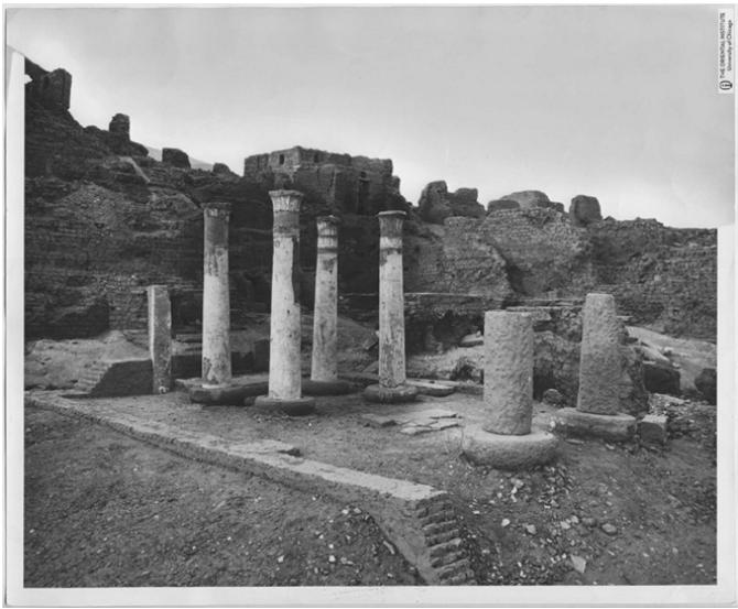
Figure 1: Butehamon house, the state of conservation in 1930 (photo by Holscher).
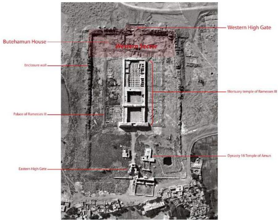
A general view of the Medinet Habu temple precinct The Western High Gate
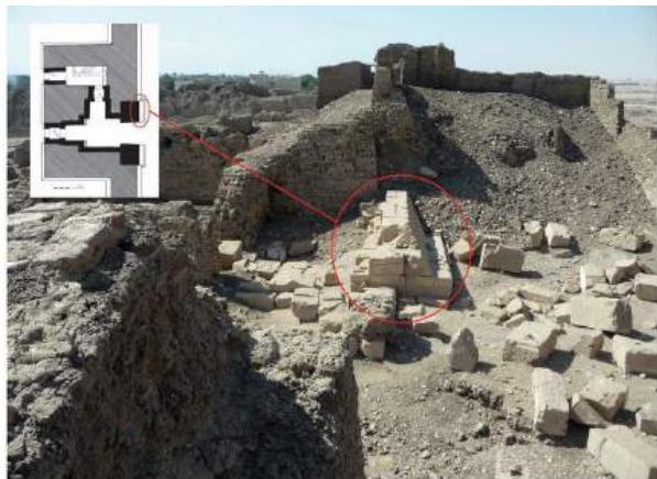
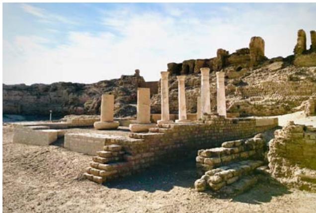
The base of the gate's southern tower (circled above in the photo and reconstructed plan) represents some of the few stones belonging to that edifice that are still in their original positions. The remainder - excepting those that have been quarried for reuse in other buildings - lie scattered about the immediate area of the gate, as can be seen above.
(b)
(c) Figure 2: A general view of the Medinet Habu temple precinct (a), the western gate (b), view of the south-west corner of Medinet Habu temple Percint, Butehamon House. (photos' editing by Ray Johnson 2019)[5].
Here one can see an area of ancient pavement that is still in position - in the background is the Butehamun House. In the foreground is an abandoned, overturned sun shelter that used to be employed by security personnel; this area of the precinct is no longer guarded.
View of the South-West Corner of the Medinet Habu Temple Precinct
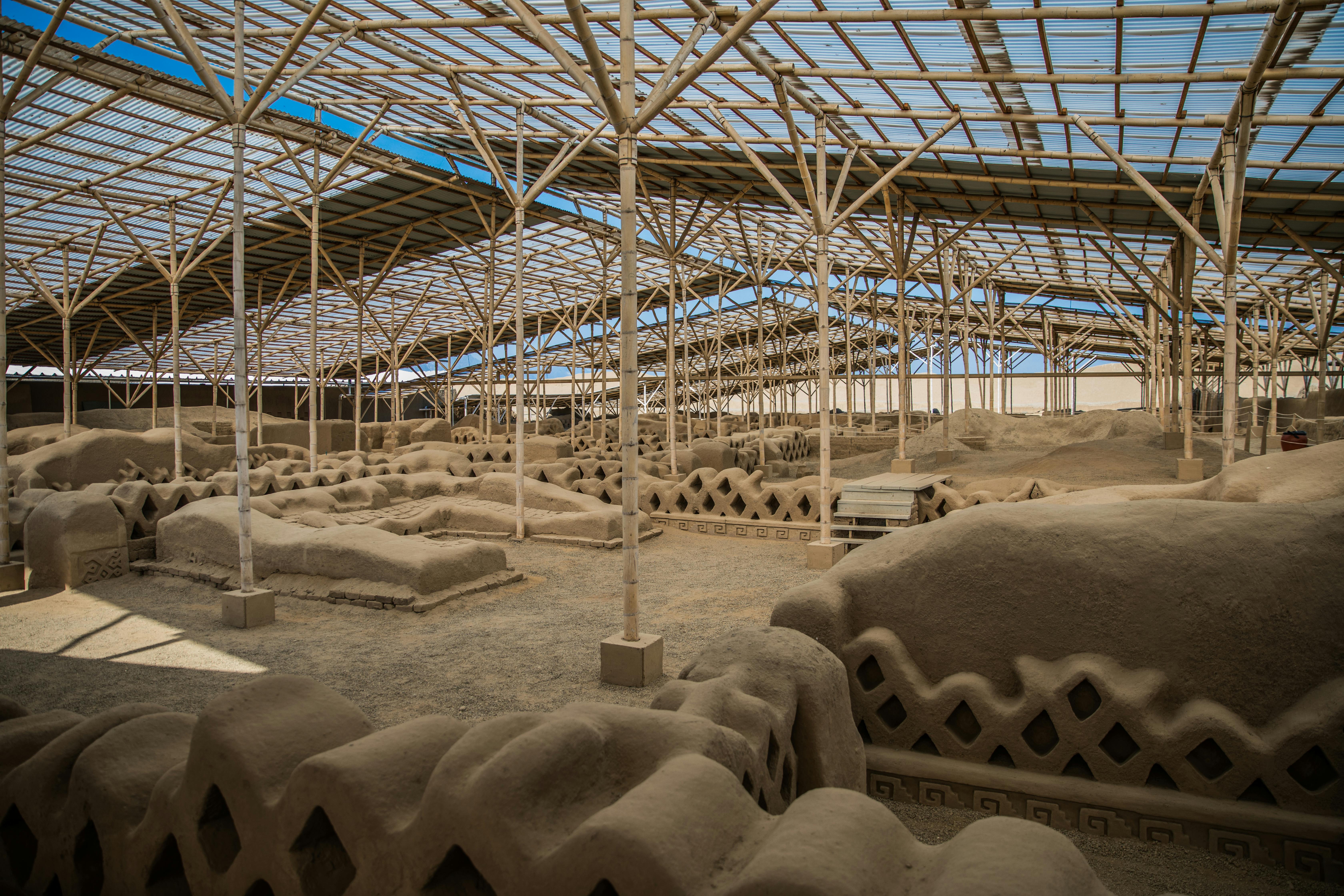
The royal scribe and overseer of the royal treasury in Theban necropolis. Butehamon held office during the reign of Pinudjem I in the 21st Dynasty 1054 BC. The Epigraphic Survey, Oriental Institute, University of Chicago excavated and restored the House of Butehamon in 1930-31and it is currently a conservation project in Habu funded by grant from USAID Egypt [5]. The House of Butehamon consists of two sections surrounded by mud brick walls, four columns in the western section and two columns (with large parts missing) that were fallen, un-plastered, in the eastern section. The plaster was in bad condition and was missing in many areas. The building materials used in the House of Butehamon are stone, plaster and mud brick. The condition survey indicates that the plaster and the stone have suffered from weathering; erosion, degradation, cracks, flake, detachment, losses and disaggregation are present, beside the previous intervention that was used; cement. It appears that the ancient builders applied the plaster on the stone, then they carved it, but there are many other layers added later and have covered the inscription in different tonality.
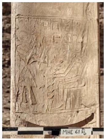
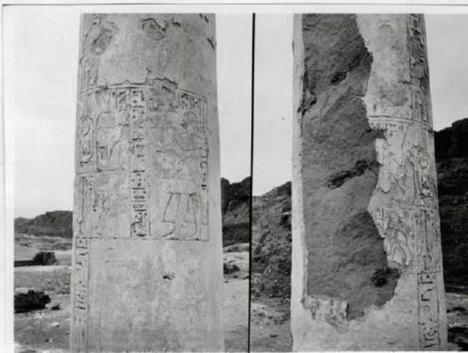 Figure 3: The reliefs of the column n.60 1930, (photo by University of Chicago).
The aim of restoration is not only to conserve the integrity of the cultural resource, but also to reveal its cultural values and to improve the legibility of its original design and bringing back the original by rebuilding a lost form.
## II. CONSERVATION & RESTORATION PROCESSES
The building materials used in the House of Butehamon are Stone, Plaster and mud bricks. The condition survey indicates that the plaster and the stone have suffered from weathering; Erosion, degradation, cracks, flake, detachment, losses and disaggregation are presented, beside the previous intervention that was used cement. The technique used appears that they applied the plaster on the stone, then they carved it, but there are many other layers added later and have covered the inscription in different tonality. Next season we will investigate and we will analyze of some types of the plaster to collect more information than the check by naked eye.
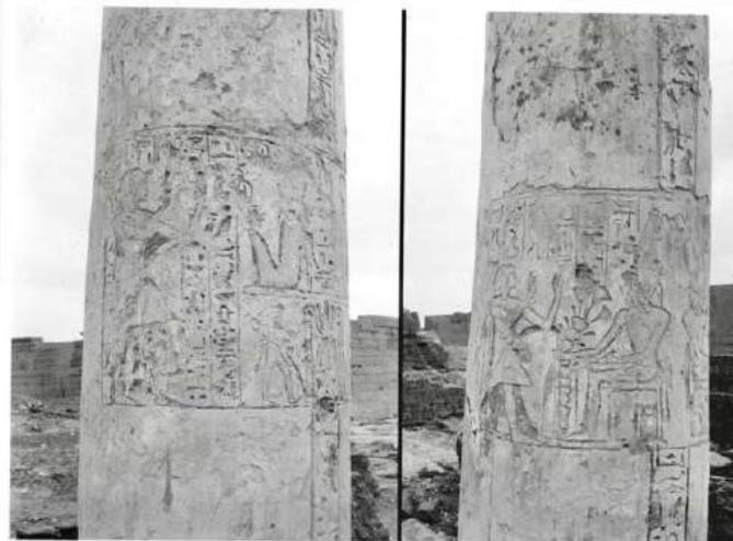
Figure 4: The reliefs of the column n.61 in 1930, (photo by University of Chicago).
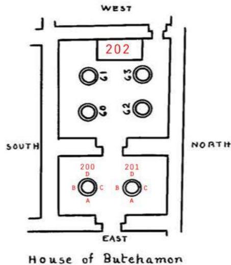
MH.E Figure 5: Butehamon house Plan, (Hölscher 1930) [1].
a) Intervention performed
1) Study of the state of conservation and Graphic documentation of mud brick walls and the four stone columns, shows the state of conservation for both the stone and plaster, indicating the dangerous areas to be consolidated.
2) Investigate, detect the original foundations and Analysis.
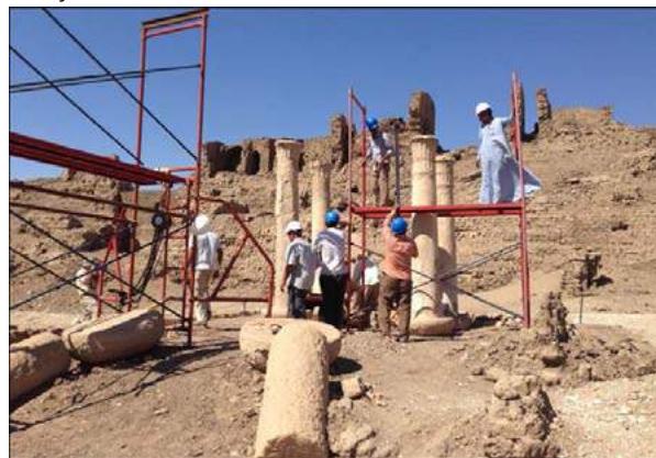 Figure 6: Site under preparation phase, scaffolding installed, 2016.
3) Restoration & Reconstruction of mud brick walls and its foundations; consolidation and reconstruction.
4) Restoration, of the columns, dismantling and straightening of the two inclined stone columns.
## i. Study of the state of conservation and graphic documentation
With the conservators trained team, the focus was on how to identify manifestations and description of damage and labeled according to the descriptive vocabulary of cases of decay, which is universally as the language of restoration. And how to transfer the cases of damaged signed on printed photo manually to draw accurately scaled on computer, using the Wacom and photoshop program.
The examination is carried out on one level: a general examination in situ with the naked eye and with simple instruments, as an USB microscope and magnifying lenses in order to determine both the techniques and materials used, and the alterations.
The examination of a work of art as the initial step in its conservation or restoration cannot be limited to a technical investigation, but must also include a critical archaeological study. Indeed, three types of examination are essential: archaeological, technological and etiological (the study of the causes of alteration)[7].
Study and documentation of the state of conservation of objects are very important before, during, and after conservation processes as a record. The purpose of documentation is to define the exact characteristics of the object, not only as they appear now, but also as they were originally, and what they have become in the course of history, and to provide a detailed report of the results of the examination, to reveal the technical structure of the work and to identify the alterations which this structure has undergone [4]. The documentations for the condition and treatment of stone objects were done in two methods:
- Photography as a record by images in digital, they have taken before the conservation works, during and after treatment.
- Graphic documentation or Survey schemes by signs of different patterns on every deterioration phenomenon on drawings prepared by the conservators using computer.
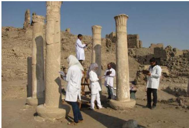
Figure 7: Site before restoration, studying the state of conservation of the columns.
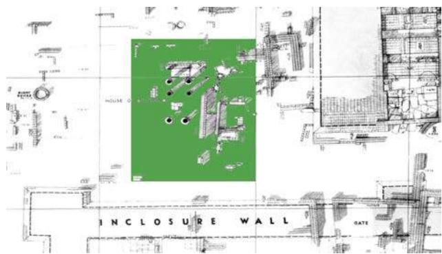
Figure 8: The excavation map for the archaeological remains of the House of Butehamon Done in 1930 by Holscher.
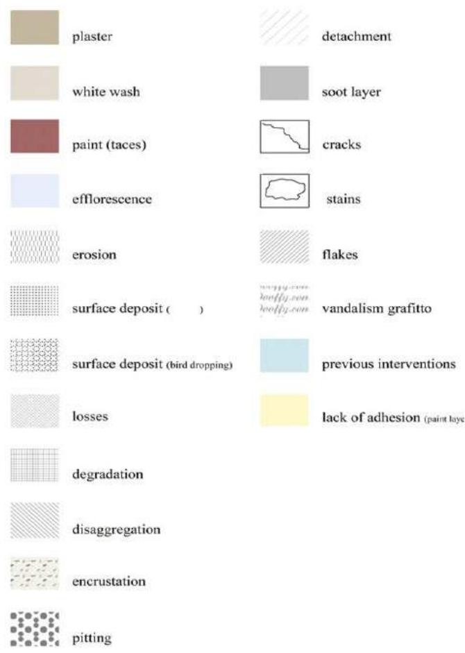
Figure 9: Shows table of types of decay signed in different patterns and colors for documentation as a key to describe the type of damage that exists.
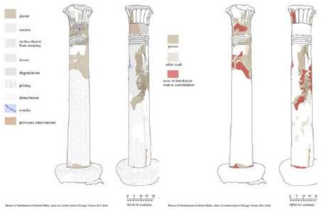
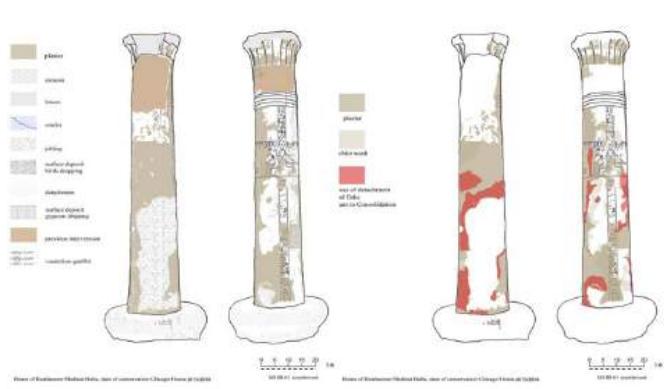 Figure 10: The graphic documentation of two sides of the Column n 61 south east of the House of Butehamon with types of decay presented and signed in different colors and pattern.
The state of conservation is the result of a synthesis of the collected data plus a critical reading of the surface. To compile the survey schemes, it is necessary to have direct knowledge of the constituent materials and execution techniques, and an analytical verification of their reactions to the different decay phenomena and to have drawings for the object to allow sufficiently accurate analytical reading of the decay. Sometimes the surface erupts into blisters; sometimes the stone loses all integrity and simply crumbles away. Sometimes the stone may look perfectly sound to the naked eye, while below the surface it has lost its cohesion [7].
One of the problems that is being discussed regarding the states of stone degradation is that of finding a common language to express the aspects of degradation. Even in English, there are a bewildering number of terms that can mean different things. While we can agree on terms to describe the types of decay we observe, it can be difficult to determine the severity or rate of decay, so the conservators' team has been provided with a final glossary of decay terms in English and Arabic to be unambiguous from the us.
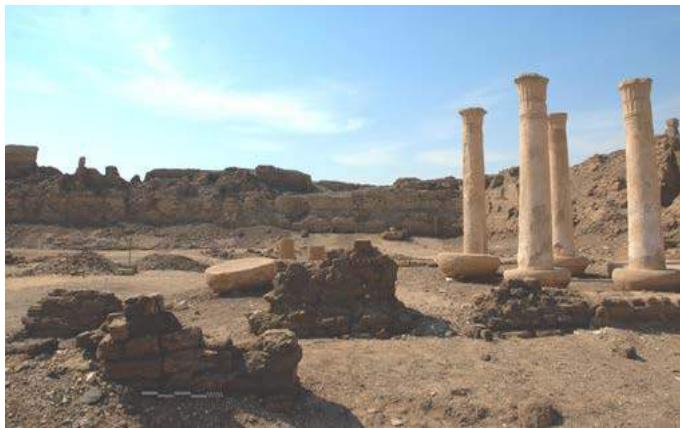
Figure 11: The conditions of the old mud brick and stone columns walls before restoration.
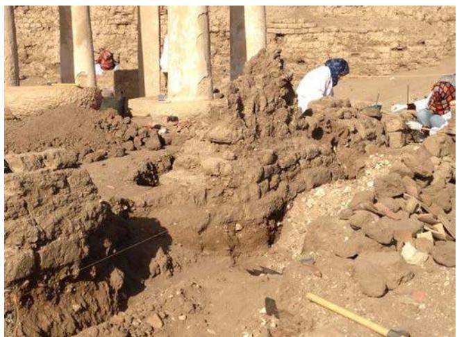 Figure 12: The site, during the clearing of the north side section of the original 21st dynasty adobe wall.
Stone decay takes many different forms. Sometimes the stone weathers away gradually, leaving a sound surface behind; sometimes large scales of stone drop away in one go. Sometimes the surface erupts into blisters; sometimes the stone loses all integrity and simply crumbles away [3]. Sometimes the stone may look perfectly sound to the naked eye, while below the surface it has lost its cohesion.
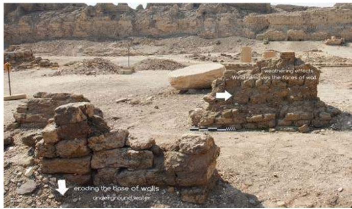
Figure 13: The state of conservation of the old mud brick walls before the restoration works.
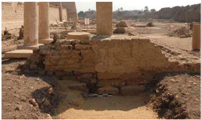 Figure 14: The state of conservation of the old mud brick foundation before the restoration works.
The four columns that appear to have been moved during the excavations of 1930, there are evidence of adding recently lime mortar between the column and its base and they have been restored using cement mortar and lime mortar. There is a tendency in columns. The bases of the columns built on a foundation of mud bricks. Four columns in the western section are plastered and two columns (with large parts missing) that were down to earth, no plastered in eastern section. the plaster was in bad condition and were missed in many areas. The plasters are in bad condition, a lot of lost because of weathering and the technique used where they had Applieda very thick layer of plaster to be good for carving.
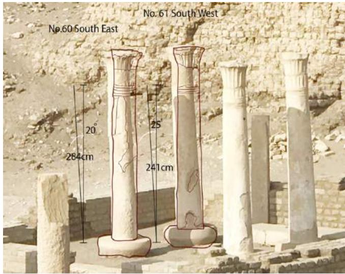 Figure 15: The inclination of the column of South East n.60 of
$20^{\circ}$ and the column of South West n.61 of $25^{\circ}$, looking from North side.
ii. Investigate, detect the original foundations and Analysis of plaster layer of stone columns.
It was investigated by cleaning the foundation and we found traces of old mud bricks which it defined the wall angel from the north side. Cleaning of the area around the mud brick walls to investigate the shape and the condition of the foundation of the mud bricks.
Unfortunately, it became evident that the mud brick walls were in a much better condition in the time of Holscher, 1920 - 1930. In fact, our method of treatment of the old mud-brick walls in Butehamon based on the historical background through the excavation in 1930 and the information we have gathered during the research of the foundation lines of the walls [11].
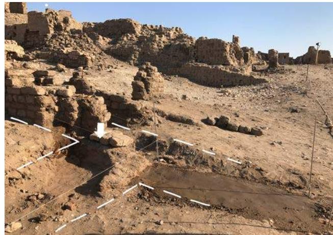
Figure 16: The foundation of the east entrance wall.
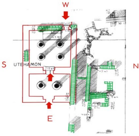
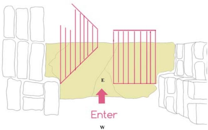
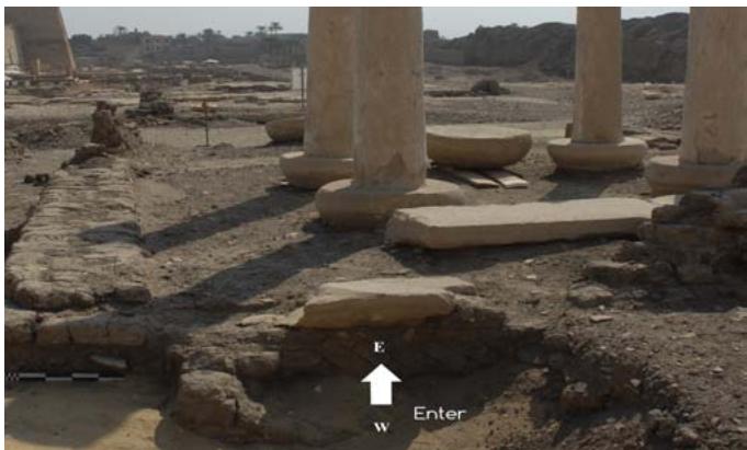 Figure 17: The plan of 1930, in green color the rests of old wall parts (a), illustrative drawing of the entrances direction (b), pic shows the entrance in site.
- It was reused mud brick of Ramses III (The larger size is $43\mathrm{cm} \times 21\mathrm{cm} \times 13$ ) as a basis for the north, south and west walls, as well as in the foundation of the two columns in the western section, where we found the mud brick reused (large Ramses III) on the basis of the two columns in a vertical way.
- The four columns in western section, they have been moved during the excavation in 1930, there are evidences of confirmation; the filling mortar used to close the joint between the base and the column body is different than the original plaster (three samples has taken to analyze by XRF & XRD to compare the elements and compounds in sample with the original one.
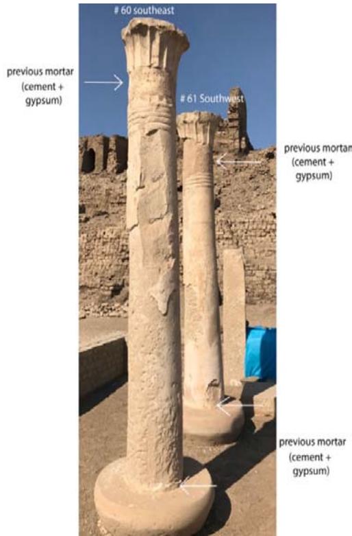 Figure 18: Shows the parts of the previous mortar used to reassemble the column of South East # 60 and the column of Southwest # 61 in 1930.
- The entrances and exits of Butehamon documented on Holscher'ssex cavation map are one direction, it means that the doors can open to inside direction, but we have found the cross stone of the door in opposite direction comparing with other two, it means that the west door open inside, so it's an entrance from outside to the western section. Unfortunately, it became evident that the mud brick walls were in a much better condition in the time of Holscher.The mud brick walls of the main entrance of the house of Butehamon in east side are completely missed and documented in Holscher's map excavation [1][5].
The most of original mud brick walls are in poor condition because of weathering; falling water in the form of rain and make the surface much more fragile, and rising groundwater seeps into the bottom of the walls, and as this dries the salts in the water crystalline on the wall surface, eroding the base of wall. It's so windy for many months in Luxor winter.
Wind removes the faces of walls. Wind can carry desert sand and this blast and abrades the walls. Humans move out and animals, birds, insects, and reptiles move in to mud brick building. Animals can excavate burrows in earthen material like foxes, and by depositing their waste they can accelerate the rates of erosion. Sometimes the people who come to visit the monuments in the park cause damage to them. This is because taking the same path through a monument can cause it to erode.
Plant roots can grow through and damage the mud brick walls and buried archaeology. Plants can also trap moisture, and lower the relative temperature, which can speed up damage to the fragile mud brick structures. We have found the top of mud brick walls with no parameters, no shape because of water where dissolved the components of the mud brick and it became a block with no face.
Analysis of plaster layer of stone columns: The purpose of the investigation and documentation is to provide a detailed report of the results of the examination, the methods used, and the conservation treatment. The examination of a work of art as the initial step in its conservation or restoration cannot be limited to a technical investigation, but must also include a critical archaeological study. Indeed, three types of examination are essential: archaeological, technological and a etiological (the study of the causes of alteration). The technical examination is always carried out on two levels: a general examination in situ with the naked eye or with simple instruments, and a special examination of characteristic samples in the laboratory. In order to determine both the techniques and materials used, and the alterations and their causes, one must proceed systematically from the support to the paint layer or plaster, taking into account the climatic environment [11].
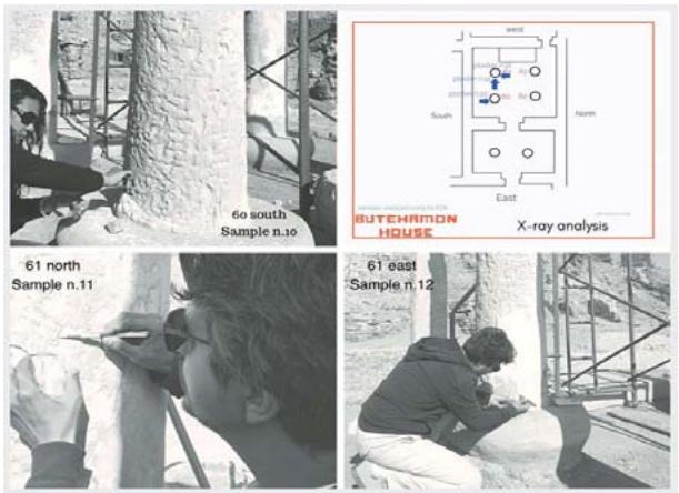 Figure19: Shows the places of plaster samples were taken.
The samples are examined using both methods X-ray diffraction and X-ray fluorescence to identify the compounds and the elements in samples.
The powder samples are examined by using IEOL X-ray diffractometer model ISX-60 PA of the Central Laboratory of El Minya University. The analysis was run with Cu K Radiation, Ni filtered (=1.54184 A) at 35 Kv and 15 mA, under a normal scanning speed of 2/1 minute, within the range of 20 = 4-100. The same samples are examined by using EDX micro analytical methods. And the EDX micro analytical methods used to identify the elemental arrangement for the samples collected from different places can be put in a decreasing order according to their concentration.
Three samples have been taken from plaster layer was applied to give a smooth finish to columns surface considered unsuitable for carving. One sample was taken from the bottom of the column 60 east side close to the base, and two samples were taken from both sides north and east side of the column 61 to identify the elements and compounds used for plastering. Places of samples were defined through naked eye examination and experience of the conservator.
X-ray fluorescence was done using the EDX micro analytical methods to identify the samples and to evaluate their different components.
X-ray diffraction was done using IEOL X-ray diffractometer model ISX-60 PA of the Central Laboratory of El Minia University
The analysis was run with Cu K Radiation, Ni filtered (=1.54184 A) at 35 Kv and 15 mA, under a normal scanning speed of 2/1 minute, within the range of 20 = 4-100.
Sample n.10 (plaster), column n.60 south side system resolution = 61 eV
Quantitative method: ZAF (5 iterations).
Analyzed elements combined with: O (Valency: -2)
Method: Stoichiometry Normalized results.
Nos. of ions calculation based on 32 anions per formula.
Standards:
### C K CaCO3 01/12/93
Mg K MgO 01/12/93
AI K AI2O3 23/11/93
Si K Quartz 01/12/93
### S K FeS2 01/12/93
### K K MAD-10 02/12/93
Ca K Wollas 23/11/93
Fe K Fe 01/12/93
An EDX micro analysis of the samples indicated that, the elemental arrangement for the samples collected from different places can be put in a decreasing order according to their concentration as follow:
C $(8.98\%)$, Mg $(0.27\%)$, Al $(0.73\%)$, Si $(2.02\%)$, S $(8.10\%)$, K $(0.20\%)$, Ca $(28.03\%)$, (Fe $(0.89\%)$ ).
The obtained results help understanding the weathering mechanisms affecting the object.
The sample contained C refer to an organic material founded, Ca and S and C as the major elements.
The analysis also revealed a high concentration of Sulphate S (8.10%) and calcium Ca (28.03%) ions which may be attributed to the crystallization of gypsum and anhydrite salts on the plaster. In addition, the moderate amount of Aluminum Al (0.73%) and potassium (K) (0.20%) attributed to feldspars and phyllosilicates group. EDXS analysis indicated small quantities of Magnesium (0.27%). The presence of relatively high amounts of iron (0.89%) and also due to atmospheric pollution. They play an important role in deterioration.
Figure 20: The data table of elements detectors, used in examination.
<table><tr><td>Elmt Type</td><td>Spect.%</td><td>Element%</td><td>Atomic%</td><td>Compound ions</td><td>Nos, of</td></tr><tr><td>CKED</td><td>8,98</td><td>14,94</td><td>CO2</td><td>32.90</td><td>7.54</td></tr><tr><td>MgKED</td><td>0.27</td><td>0.22</td><td>MgO</td><td>0.44</td><td>0.11</td></tr><tr><td>AI KED</td><td>0.73</td><td>0.54</td><td>Al2O3</td><td>1.38</td><td>0.27</td></tr><tr><td>Si KED</td><td>2.02</td><td>1.44</td><td>SiO2</td><td>4.32</td><td>0.72</td></tr><tr><td>SKED</td><td>8.10</td><td>5.05</td><td>SO3</td><td>20.23</td><td>2.55</td></tr><tr><td>KKED</td><td>0.20</td><td>0.10</td><td>K2O</td><td>0.24</td><td>0.05</td></tr><tr><td>Ca KED</td><td>28.03</td><td>13.97</td><td>CaO</td><td>39.22</td><td>7.05</td></tr><tr><td>Fe KED</td><td>0.89</td><td>0.32</td><td>Fe2O3</td><td>1.27</td><td>0.16</td></tr><tr><td>O</td><td>50.78</td><td>63.42</td><td></td><td>32.00</td><td></td></tr><tr><td>Total</td><td>100.00</td><td>100.00</td><td></td><td>100.00</td><td></td></tr><tr><td></td><td></td><td></td><td></td><td>Cation sum 18.45</td><td></td></tr></table>
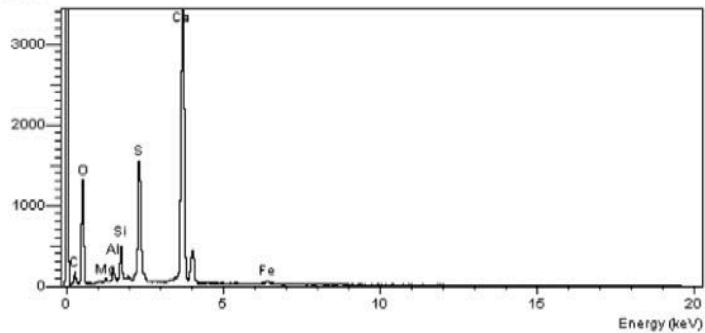
Counts Figure 21: The chart of elements in sample n. 10.
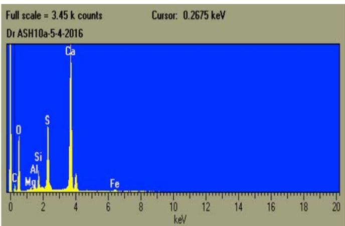 Figure 22: The diagram of elements detectors, in sample n.10.
#### Results of XRD
The same sample was analyzed and examined by using JEOL X-ray diffractometer model JSX-60 PA.
X-ray diffraction pattern of the powder samples have proved that anhydrite, quartz and calcite are the principal minerals in sample of plaster taken from Butehamon are found in sample with gypsum as traces.
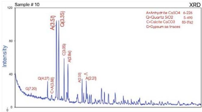 Figure 23: The diagram of compounds in sample n. 10 and its charts.
Sample #11 (plaster), column n.61north side
Description: Whitish fine plaster layer" tan" applied and covered the inscriptions at the top of north side of column 61, probably later period.
System resolution $= 61 \mathrm{eV}$
Quantitative method: ZAF (4 iterations).
Method: Stoichiometry Normalized results.
Nos. of ions calculation based on 32 anions per formula.
1 peak possibly Omitted: 12.00keV
Standards:
### C K CaCO3 01/12/93
Na K Albite Na (AlSi3O8) 02/12/93
Mg K MgO 01/12/93
AI K AI2O3 23/11/93
Si K Quartz 01/12/93
### K K MAD-10 02/12/93
Ca K Wollas 23/11/93
Fe K Fe 01/12/93
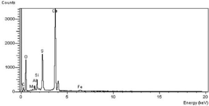 Figure 24: The chart of elements detectors, sample n. 11 which is close to sample n.10
Figure 25: The data table of elements detectors, used in examination -sample n.11.
<table><tr><td>Elmt Type</td><td>Spect.%</td><td>Element%</td><td>Atomic%</td><td>Compound ions</td><td>Nos, of</td></tr><tr><td>C K ED</td><td>6.19</td><td>10.50</td><td>CO2</td><td>22.67</td><td>5.18</td></tr><tr><td>Na K ED</td><td>0.29</td><td>0.26</td><td>NazO</td><td>0.39</td><td>0.13</td></tr><tr><td>Mg K ED</td><td>0.43</td><td>0.36</td><td>MgO</td><td>0.72</td><td>0.18</td></tr><tr><td>Al K ED</td><td>1.55</td><td>1.17</td><td>AlzO3</td><td>2.93</td><td>0.58</td></tr><tr><td>Si K ED</td><td>4.05</td><td>2.94</td><td>SiO2</td><td>8.66</td><td>1.45</td></tr><tr><td>S K ED</td><td>12.27</td><td>7.80</td><td>SO3</td><td>30.87</td><td>3.85</td></tr><tr><td>K K ED</td><td>0.68</td><td>0.35</td><td>KzO</td><td>0.82</td><td>0.17</td></tr><tr><td>Ca K ED</td><td>22.06</td><td>11.22</td><td>CaO</td><td>30.87</td><td>5.54</td></tr><tr><td>Fe K ED</td><td>1.62</td><td>0.59</td><td>Fe2O3</td><td>2.32</td><td>0.29</td></tr><tr><td>O</td><td>50.86</td><td>64.81</td><td></td><td>32.00</td><td></td></tr><tr><td>Total</td><td>100.00</td><td>100.00</td><td></td><td>100.00</td><td></td></tr><tr><td></td><td></td><td></td><td></td><td>Cation sum 17.38</td><td></td></tr></table>
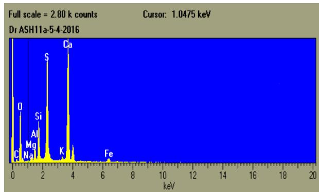 Figure 26: The diagram of elements detectors, in sample n.11.
C $(6.19\%)$, Na $(0.29\%)$, Mg $(0.43\%)$, Al $(1.55\%)$, Si $(1.05\%)$, S $(12.27\%)$, K $(0.68\%)$, Ca $(22.06\%)$, (Fe $(1.62\%)$.
The obtained results help understanding the weathering mechanisms affecting the object. The sample contained C refer to an organic material founded, Ca and S and C as the major elements. The analysis also revealed a high concentration of Sulphate S (12.27%) and calcium Ca (22.06%) ions which may be attributed to the crystallization of gypsum and anhydrite salts on the plaster.
In addition, the moderate amount of Aluminum Al (1.55%) and potassium (K) (0.68%) attributed to feldspars and phyllosilicates group. EDXS analysis indicated small quantities of Magnesium (0.43%). The presence of relatively high amounts of iron (1.62%) and also due to atmospheric pollution. They play an important role in deterioration.
Results of XRD
The same sample was analyzed and examined by using JEOL X-ray diffractometer model JSX-60 PA.
X-ray diffraction pattern of the powder samples have proved that anhydrite, quartz and calcite are the principal minerals in sample of plaster taken from Butehamon are found in sample with gypsum as traces [12].
Anhydrite, quartz and calcite are the principal minerals in the sample11.
Gypsum $\{\mathrm{CaSO4(H2O)2}\}$ is characterized by its strongest d-lines at (d=4.28 A; 7.59 A & 3.06 A; PDF n.74-1904). Calcite mineral (CaCO3) is characterized by its strongest d-lines at (d= 3.04 A, 2.28 A & 1.88 A; PDF n.83-1762). Quartz (SiO2) is characterized by its strongest d-lines at (d=3.34 A, 4026 A & 1.82A; PDF n. 5-490). Anhydride (CaSO4) is characterized by its strongest d-lines at (d=3.50 A, 2.85 A & 2.33A; PDF n.6-226) Anorthoclase (Na,K) AlSi3O8, it is Colorless, also white, pale creamy yellow.
The mineral anorthoclase is a crystalline solid solution in the alkali feldspar series, in which the sodium-aluminum silicate member exists in larger proportion. Anorthoclase occurs in high temperature sodium rich volcanic and hypabyssal (shallow intrusive) rocks. The mineral is typically found as a constituent of the fine gained matrix or as small phenocrysts which may occur as loose crystals in a weathered rock.
It was first described in 1885 for an occurrence on Trapani Province and Sicily. The name is from the Greek for oblique and fracture, descriptive of the cleavage.
Essential elements; Al, Na, O, Si
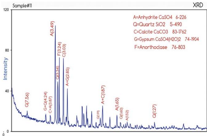 Figure 28: The data table of elements detectors, used in examination -sample n.12. Figure 27: The diagram of compounds in sample n. 11 and its charts.
Sample #12 (plaster), column n.61east side
Results of XRF
Description: White thick plaster/mortar used to fill gaps between the column and its base, probable new restoration used in 1930, south side of column n.61.
System resolution $= 64 \mathrm{eV}$
Quantitative method: ZAF (3 iterations).
Analyzed elements combined with: O (Valency: -2)
Method: Stoichiometry Normalized results.
Nos. of ions calculation based on 32 anions per formula.
2 peaks possibly omitted: 0.00,0.26 keV
Standards:
<table><tr><td>Elmt Type</td><td>Spect.%</td><td>Element%</td><td>Atomic%</td><td>Compound ions</td><td>Nos, of</td></tr><tr><td>Mg K ED</td><td>0.22</td><td>0.20</td><td>MgO</td><td>0.36</td><td>0.10</td></tr><tr><td>Al K ED</td><td>1.56</td><td>1.30</td><td>Al2O3</td><td>2.95</td><td>0.63</td></tr><tr><td>Si K ED</td><td>5.39</td><td>4.33</td><td>SiO2</td><td>11.54</td><td>2.11</td></tr><tr><td>S K ED</td><td>18.78</td><td>13.20</td><td>SO3</td><td>46.90</td><td>6.43</td></tr><tr><td>K K ED</td><td>0.35</td><td>0.20</td><td>K2O</td><td>0.42</td><td>0.10</td></tr><tr><td>Ca K ED</td><td>26.03</td><td>14.64</td><td>CaO</td><td>36.43</td><td>7.12</td></tr><tr><td>Fe K ED</td><td>0.98</td><td>0.40</td><td>Fe2O3</td><td>1.41</td><td>0.19</td></tr><tr><td>O</td><td>46.68</td><td>65.74</td><td></td><td>32.00</td><td></td></tr><tr><td>Total</td><td>100.00</td><td>100.00</td><td></td><td>100.00</td><td></td></tr><tr><td></td><td></td><td></td><td></td><td>Cation sum 16.68</td><td></td></tr></table>
AI K AI2O3 23/11/93
### K K MAD-10 02/12/93
The EDX micro analytical methods were performed to identify the samples and to evaluate their different components. The investigations results are shown in.
## Results of XRD
The powder samples are examined by using JEOL X-ray diffractometer model JSX-60 PA of the Central Laboratory, El Minya University. The analysis was run with Cu K radiation, Ni filtered (=1.54184 A) at 35 Kev and 15 mA, under a normal scanning speed of 2 /1mint, within the range of 2 O = 4-100. X-ray diffraction pattern of the powder samples have proved that gypsum, quartz and Anhydrite are found in sample# 12. Anhydrite and quartz are the principal minerals in the samples12. Gypsum $\{\mathrm{CaSO4(H2O)2}\}$ is characterized by its strongest d-lines at (d=4.28 A; 7.59 A & 3.06 A; PDF n.74-1904). Quartz (SiO2) is characterized by its strongest d-lines at (d=3.34 A, 4026 A & 1.82A; PDF n. 5-490). Anhydride (CaSO4) is characterized by its strongest d-lines at (d=3.50 A, 2.85 A & 2.33A; PDF n.6-226).
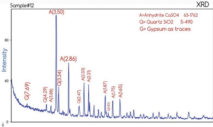 Figure 29: The diagram of compounds in sample n. 12 and its charts.
## iii. Restoration & Reconstruction of mud brick walls
Ancient Egyptian architecture is, one of the most influential civilizations throughout history, which developed a vast array of diverse structures and great architectural monuments along the Nile, including pyramids and temples.
Many Egyptian mud bricks structures have disappeared because they were situated near the cultivated area of the Nile Valley and were flooded as the river bed slowly rose during the millennia, or the mud bricks of which they were built were used by peasants as fertilizer. Others are inaccessible, new buildings having been erected on ancient ones. Fortunately, the dry, hot climate of Egypt preserved some mud brick structures. Examples include the village Deir al-Madinah, Also, many temples and tombs have survived because they were built on high ground unaffected by the Nile flood and were constructed of stone. In the Butehamon structure case, which is dated to 21st dynasty, all the archaeological remains of mud bricks walls refer to that they've been reused Ramses bricks (measuring $43 \times 21 \times 13$, big size) for foundation sections and smaller bricks for walls (measuring $30 \times 15 \times 9$ cm, smaller size) [1].
Our Conservation intervention is to prevent or substantially reduce continuous decay by supporting unstable walls, by replacing critical features, and by adding new mud bricks to the foundation and to the top surfaces. The goal of the project is to protect the original fabric from decay, but the results also add an important dimension, providing a clearer interpretation of the spaces defined by the walls.
Mud bricks, or adobe, are one of the world's oldest building materials. They are inexpensive, simple to make, environmentally friendly, and used all over the world to make low-cost homes and fireproof buildings. How to make mud bricks in site?
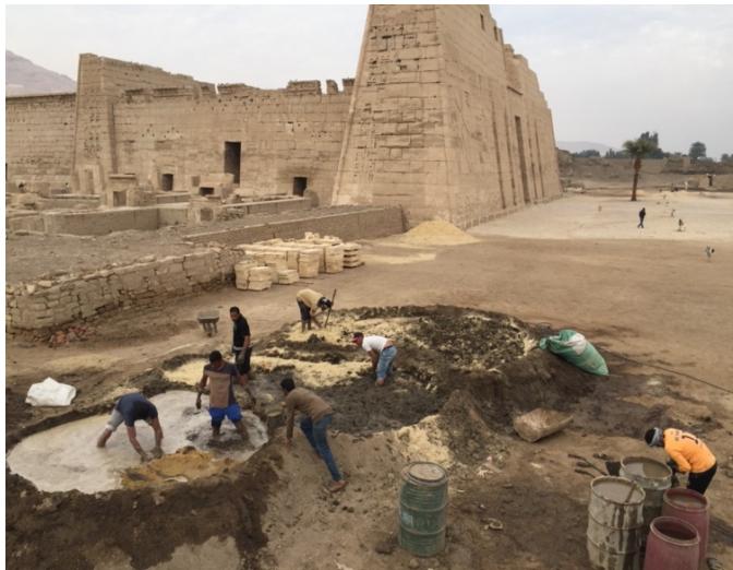
Figure 30: The big pit, large hole filled with water.
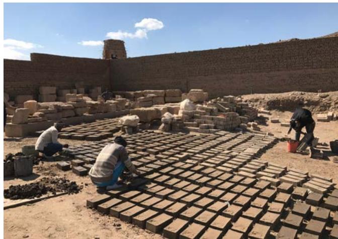 Figure 31: Workers add the mixture (clay & straw) to the mold for making adobe bricks.
Before we begin, make sure to clear out a dry area for making bricks. They could take several weeks to dry and need to be protected from rain.
Step 1: Collect Soil To begin, you need to collect enough loamy soil to make your bricks. Soil from the top or sides of a natural clay.
Sift the collected soil through the screen to remove any stones that can weaken the bricks and cause them to crack.
Step 2: Make the Mold
Step 3: Dig a Pit
Use a wheelbarrow for mixing the soil if you want to make a few bricks, but you will need a pit for a larger project. Dig a large hole in the ground that is three feet deep. Fill the hole with water allow it to drain out itself.
This could take up to a day, but is necessary because it will prevent the walls from crumbling during the mixing process.
Step 4: Add the Soil and Mix Fill the hole half way up with soil. Fill your bucket with water and add to the soil, mixing with a hoe or shovel. Adding some straw or manure to prevent the bricks from cracking. Add enough water to make a thick mix.
Step 5: Add Mixture to the Mold
Lay the Mold flat on to a dry ground and shovel mud into each section, filling it completely. Pat the top firmly with the back of the shovel to pack it in tightly and remove any air bubbles or excess water.
Step 6: Drying
Allow the bricks to settle before carefully lifting the mold off. Move to another dry spot to make the next five bricks. Continue this process till you have enough bricks you need.
Wait at least two weeks before checking your sun-dried bricks. All the edges should turn white before you can use them, otherwise they will crumble. You may have to wait three weeks before you can use your bricks. Sun dried bricks can last up to 30 years before they begin to crack.
Restoration & stabilization the old mud brick walls; support, consolidation and filling of gaps
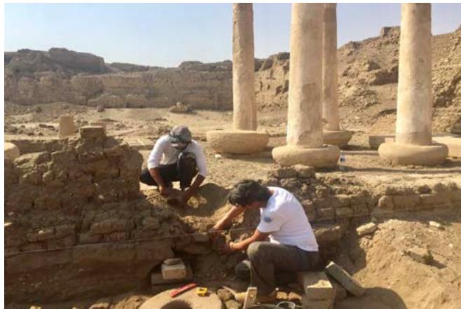
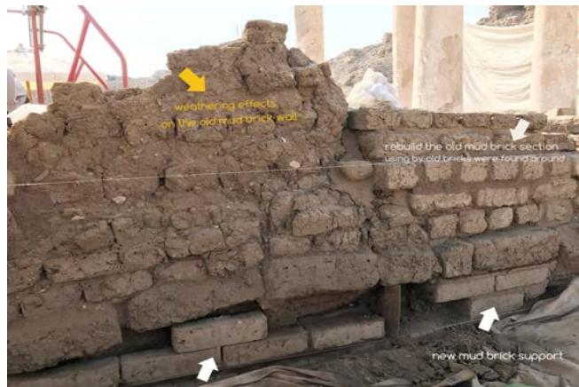 Figure 32: The senior conservator, Lotfi Hassan, the Author disassembles the inclined sections to clean, strength and rebuild them in the right position.
To find the best solutions for Medinet Habu mud bricks we are undertaking experiments with traditional materials, such as mud plasters, mud mortars and mud bricks, as well as new materials, such as using a geotextile (a porous plastic grid material) to separate the new conservation work from the archaeology features which, this method has been used in different sites in world.
Another solution to separate the new mud bricks from the old one, using natural materials covering the old mud bricks with a thick layer of clay plaster visible before using the new mud bricks.
In many cases, we used both solutions using a porous plastic grid material and using natural materials covering the old mud bricks with a thick layer of clay plaster visible before using the new mud bricks. It used in settling old mud brick level with a layer of clay after covered it with fiber grid material.
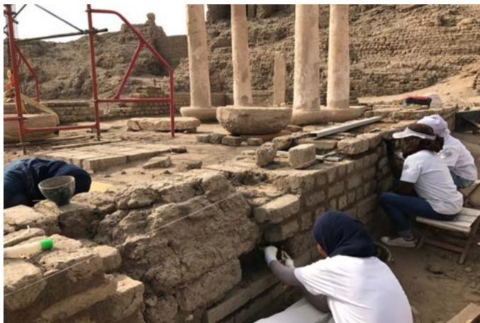 Figure 34: Replacing the damaged section with a new mud brick.
It 'been so necessary to disassemble and thoroughly rebuild the old mud-brick walls, after it has been cleaned throughout the area and found the foundation lines, it was used the same mud-brick old, who had fallen and were found around. When we look at the old mud brick before restoration, in fact, explains the rate of decay and the factors causing the damage.
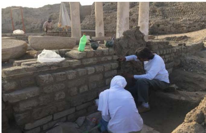 Figure 35: The conservators treat the wall after straightening & supporting.
By analyzes, found that the mud bricks consisted mainly of Quartz[SiO2 (Alphaquartz)], Albite [NaAl/Si3O8] and Anorthoclase [(Na,K) Al/Si3O8], as major minerals. Diaspore [AlO(OH)] Orthorhombic [KA/Si3O8], Kaolinite [Al2Si2O5(OH)4], Calcite [CaCO3] and K-feldspars [KA/Si3O8]. Furthermore, Montmorillonite [(Na,Ca)0.33 (Al,Mg)2SiO4·nH2O], Illite [(K,H3O)(Al,Mg,Fe)2(Al,Si)4O10 {OH)2,H2O}] present in small amounts [12].
The conditions of the walls vary, but most are in poor conditions, the result of exposure to the microenvironment and human and animal traffic. Reaping the eroded walls, the heavily eroded and undercut wall bases have been filled and packed with new mud bricks. These repairs provide support for the structure and limit the effects of damage from rising water, as the erosion occurs in the new material rather than the old material. Filling gaps, was made using clay mortar to reinforce the plates, edges and to smooth the surface of the mud bricks. It was used in two different ways and different composition; a clay mortar for new mud bricks, consists of clay, straw and Hiba and applied with a spatula, sponge and so flat, undercut, and a mortar clay to old wall of mud bricks, consisting of clay and only straw, applied with a spatula and scratched off using by the stick to give old texture.
Consolidation of old mud brick wall was done to reinforce the old mud bricks walls as a final protection after it has been lost its cohesion, using by Ethyl silicate Wacker OH 100 applied by spray through dispenser to ensure the arrival of consolidator to all decayed parts. The Wacker Consolidation System is based on Silicic acid ethyl esters and is a ready for use product. It is applied to the surface of prepared substrates where it is absorbed through capillary action in the mud bricks. The low molecular weight encourages optimum penetration into the substrate. The esters hydrolyze in the presence of atmospheric humidity and with the aid of catalysts form a Silicic acid gel. This is then converted into silicon dioxide (SiO2), to replace chemically the natural binder, which has been lost (see simplified equation) [9].
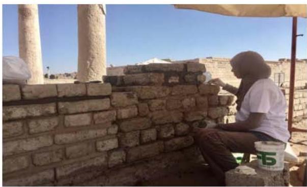
Figure 33: Shows the condition of the inclined wall in action to be restored & supported.
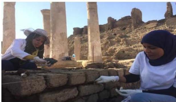
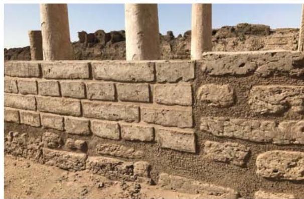
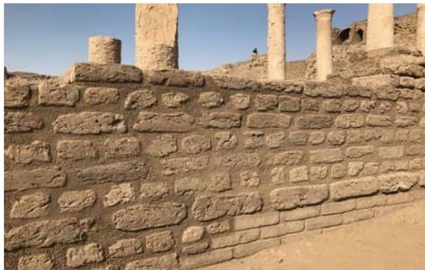
Figure 36: The conservators during the filling of gaps and joints using clay mortar for adobe wall (a, b), the wall after restoration; old parts and new section reconstructed using new mud brick, (c, d).

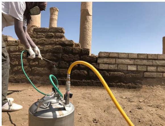 Figure 37: The conservator during the consolidation of old mud brick walls by ethyl silicates using the dispenser (a, b).
$$
\begin{array}{c} \text{Catalyst} \\\mathrm{S i (O R) _ {4}} + 4 \mathrm{H} _ {2} \mathrm{O} \longrightarrow \mathrm{S i (O H) _ {4}} + \mathrm{R O H} \end{array}
$$
$$
\mathrm {S i} (\mathrm {O H}) _ {4 -} \text {- - - - - - - - - - - - - - - - - - - - - - - - - - - - - - - - - - - - - - - - - - - - - - - - - - - - - - - - - - - - - - - - - - - - - - - - - - - - - - - - - - - - - - - - - - - - - } \mathrm {S i O} _ {2} + 2 \mathrm {H} _ {2} \mathrm {O}
$$
iv. Restoration, of the columns, dismantling and straightening of the two inclined stone columns
The columns are six, four pedestals; the base, the shaft and the capital The base is like the "foot" of the column, the shaft the "trunk", and the capital the "head", and the other two were laid on the ground; the base, the stem missing part and no capital.
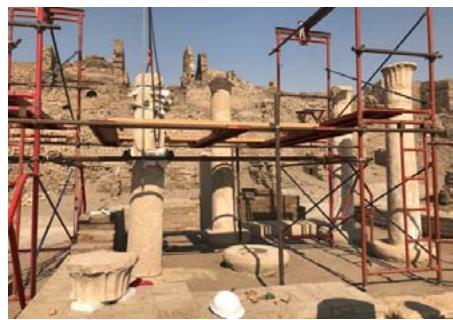
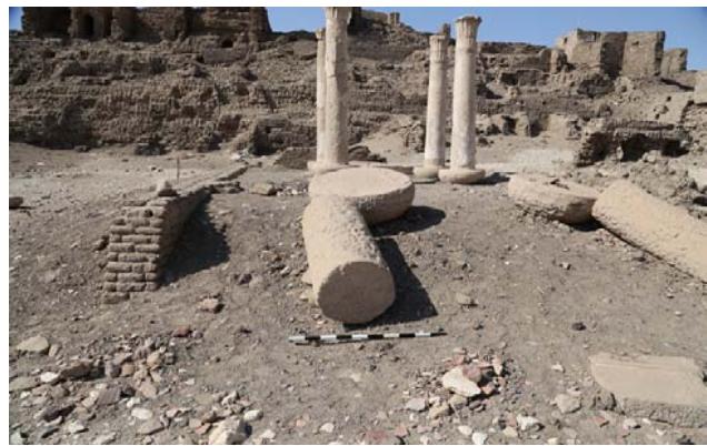 Figure 38: The Butehamon House before interventions; showing the state of conservation, 2016.
Restoration Processes of the two columns (with large parts missing, n.200-n.201)
(1) Remove the basis to excavate and detect the foundations to be consolidated and reconstructed.
(2) Consolidate and replace the foundations.
(3) Reconstruct the stone base on foundation in level
(4) Reconstruct the trunk on the base
 Figure 39: The original place of the southern column base.
To reset columns in their original place must be detected and investigated the right position of the bases of the two columns. The bases of the two columns were settled on Ramses III mud bricks (big size) in vertical position. From the original locations of the bases, we understand that the northern column is not aligned with the columns of the northwestern section, but the southern column is nearly aligned with the columns of the north in the western section [11].
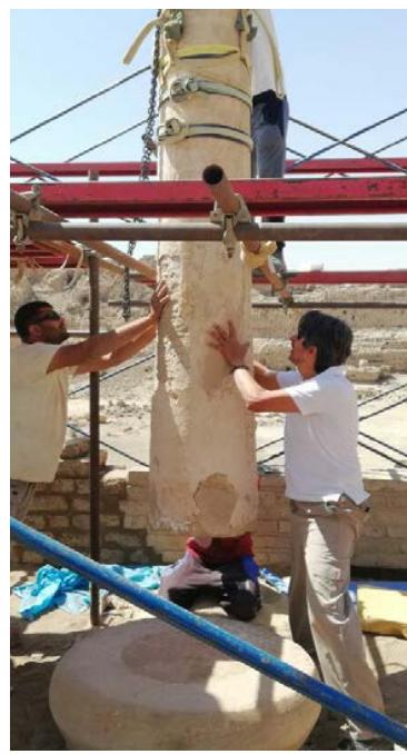
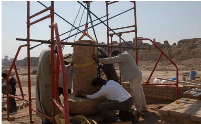 Figure 40: Senior conservator Lotfi, the Author & assistants replace the shaft part of the column on original base of the southern side.
It supported the two bases by adding rows of new big size in vertical as the same method used, after it had covered the original bases by plastic grid and covered with a layer of clay, then we did apply one clay plaster leveled. It replaced the two bases and settled in clay mortar, then the columns fixed.
The Butehamon house as in plan consists in two sections; one contains the two large parts missing, and the second section contains four plastered columns [11].
The four plastered columns that appear to have been moved during the excavations of 1930, there are evidence of adding recently lime mortar between to the column and its base and they have been restored using cement mortar and lime mortar between the shaft and the capital. There is a tendency in two southern west and southern west columns. The bases of the columns built on a foundation of mud bricks, using big size of Ramses III. Four columns in the western section are plastered and two columns (with large parts missing) that were down to earth, no plastered. the plasters are in bad condition and were missed in many areas, a lot of lost because of weathering and the technique used where they had Applied a very thick layer of plaster obviously to be good for carving.
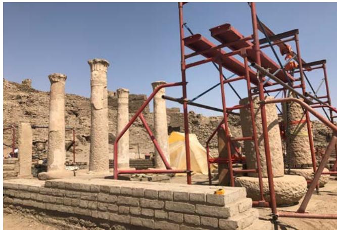
Figure 41: Shows the replacement of the two columns (with large parts missing) that were laid on the ground in final phase.
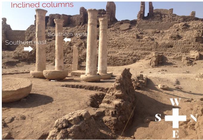 Figure 42: Illustrative photo of the two inclined columns, n.60-n.61.
Other plaster layers, also added later different than the original carved plaster that have covered the inscriptions.
Restoration Processes of the two inclined columns (southern east and southern west, n. 60, n.61)
(2) Dismantling the inclined columns by removing the capital, the shaft and the base.
(3) Excavate and stabilization of the foundation of the columns by replacing the decayed mud bricks with new bricks.
(4) Reassembly of the columns in right position using lime mortar.
- Scaffolding was set up surrounding the columns to allow for work and movement during straightening.
- The cement mortar between the capital and theshaft was removed carefully with a chisel and
scalpel, then tying the capital with a winch to ensure its stability during the intervention.
- Removing the cement joined the shaft of the columns with stone base, which was covered used with a layer of lime mortar.
- Lifting the column from the base after packing it carefully.
- Moving the column base to detect the foundation and rebuild it.
- Replace the parts of the column in right position.

(a)
(b)
(c)
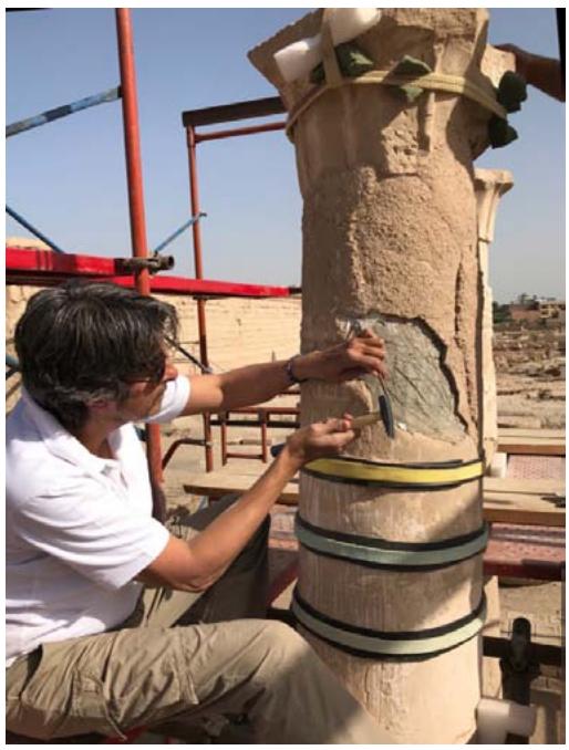
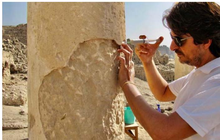
Figure 43: Detail of carved plaster of column n.60 (a), detail of carved plaster of column n.61 (b), The conservator Lotfi Hassan, the Author during the pre-consolidation of the plaster before dismantling and moving the column (c). (a)
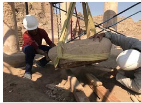
(b & c)
(d) Figure 44: The author during removing the cement between the capital and the column shaft in preparation of dismantling of the column(a), moving the column base and the site during the work (b, c), The conservator Lotfi Hassan, the Author during the replacement of the column shaft(d).
(a)
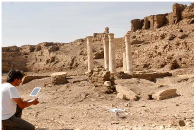
(b) Figure 45: The Butehamon House from north side, surveying using by drone before restoration (a), the House from north side after restoration of mud brick walls and stone columns (b).
## III. SITE MANAGEMENT
Cultural heritage management is about striking a balance between developing the tourism industry, generate revenue while still conserving the physical integrity of sites, promoting and celebrating their educational, historic and cultural values. According to Unesco, heritage is our legacy and cultural identity that we pass on to the next generation. Tangible features, such as monuments, groups of building, and both historic and natural sites, are considered as part of our heritage by Unesco. To influence the visitors' behavior in a positive way, cultural heritage manager can build the visitors experience around education.
The protection, conservation and effective presentation of the cultural and natural heritage should be considered as one of the essential aspects of regional development plans, and planning in general, at the national, regional or local level.
This should include the vision and goals for preserving, explain the special qualities and values of the Site, lay out policies to protect the Site and provide support for monitoring future developments planned for the Site.
World Heritage Convention" every site inscribed on the World Heritage List must have a management plan that explains how the outstanding universal value of a property can be preserved. The management plan is the central planning instrument for the protection, use, conservation and successful development of World Heritage sites. This guide offers support in developing management plans to those involved with World Heritage [8].
In Madinet Habu temples, where its enclosed area includes temples from different eras and archaeological features around the main temple, the Mortuary Temple of Ramses III which is open to the public. Conservation projects have focused on restoring the archaeological features around it and making it accessible to the public. The management of the
Butehamon House site, after the restoration is one of the projects focusing on visitor access and education, which is linked to another conservation projects in southern area, such as the restoration of southern well of Ramsses III and the mud brick walls around the main temple and the stone pavement, which it takes accesses to visitors without damage the archaeological features, so the accesses will connected the archaeological features by one direction from east to south then in future from west to north, so it will be walkway around the main temple, which will be accessible for visitors. We will publish some project of these in another volume.
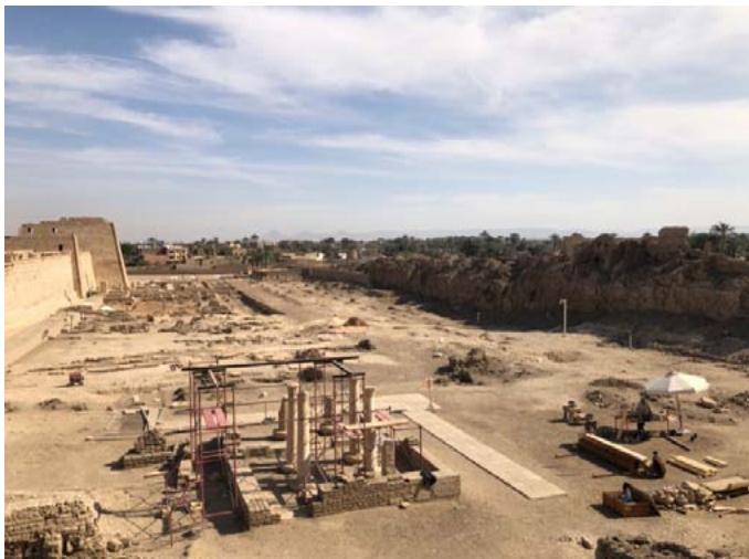 Figure 46: Show the main temple on left side and southern archaeological side which is not access to visitors.
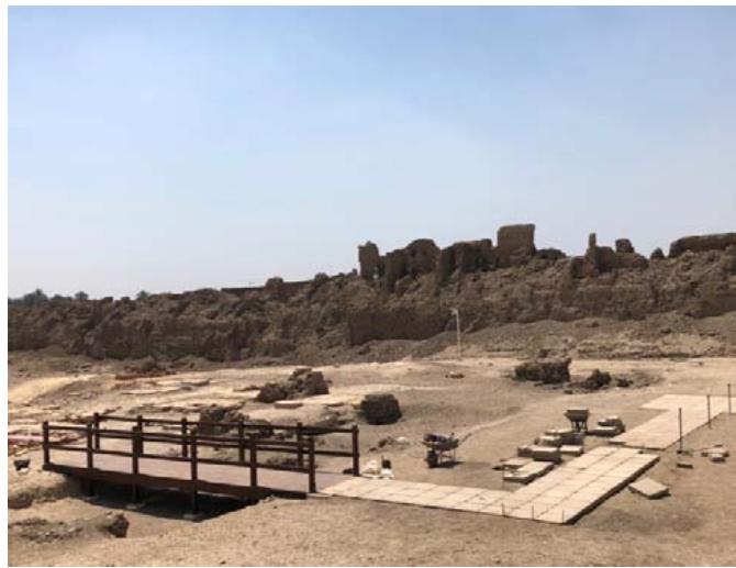
It has been planned to create a walkway of clay tiles around the house which will enable visitors to see the house and columns without entering, the work plan focused too on its site management plan and the site's coordination. And it has been built a wooden bridge to protect and cover an archaeological feature and to linked to restoration project of the Ramses III enclosure wall and its stone pavement. It has been added illustrative panels to explain the historical value of the monuments and its restoration. then the site was managed after the restoration and to protect the archaeological work and features on site, from two elements; the walkway as a guide and illustrative panel to help visitors understand the value of the archaeological site.
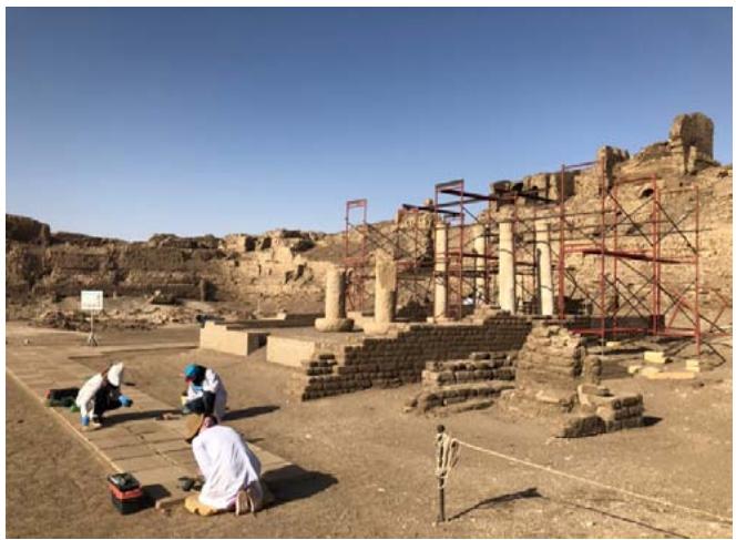
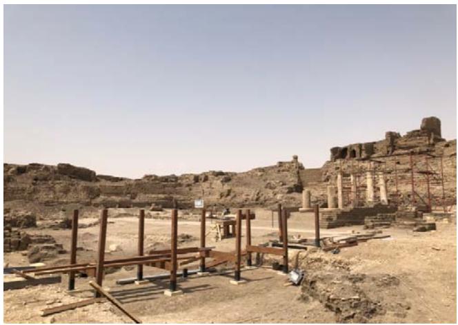
Figure 47: The conservators during the final restoration works of clay tiles of walkway.
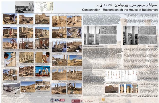
Figure 48: The construction of wooden bridge on archaeological features to protect it and to do way to reach the walkway to visit the butehamon house. (a)
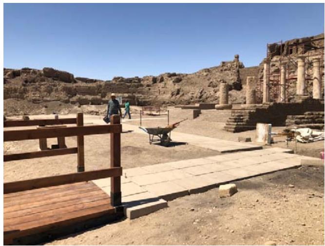
(b) (c) Figure 49: Illustrative panel, history and conservation works done (a), Views of walkway & the wooden bridge (b, c).
## IV. CONCLUSION
The main purpose of conservation is to preserve the authenticity and integrity of the cultural heritage and protect it not only from the elements but also from man who has no knowledge of cultural heritage or archaeological sites.
Visitors contribute much to further decay. More and more reliefs and wall paintings are touched as much out of curiosity as out of ignorance, without considering the consequences. Site management, should be an essential point after the restoration of archaeological sites such as temples, which include more than one place to enable it through visitor management by creating paths not very close to the archaeological features. And adding illustrative panels that would take visitors to the right places to see and learn about history without causing damage. The caretakers of these monuments as well as the tour guides had a great time responsibility to raise visitor awareness and to teach others that these monuments are part of a collective world heritage, not just Egypt's property. Several conservation actions have been undertaken to reduce the consequences of these types of deterioration, however no always and in any case with success, since experience and ability can be found wanting.
An EDX micro analysis of the samples indicated that, the elemental arrangement for the samples collected from different places can be put in a decreasing order according to their concentration as follow: Mg (0.22%), Al (1.56%), Si (5.39%), S (18.78%), K (0.35%), Ca (26.03%), (Fe (0.98%), The obtained results help understanding the weathering mechanisms affecting the temple. The $12^{\text{st}}$ sample contained Ca and S as the major elements. The analysis also revealed a high concentration of sulfate S (18.78%) and calcium Ca (26.03%) ions which may be attributed to the crystallization of gypsum and anhydrite salts on the wall reliefs. In addition, the moderate amount of Aluminum Al (1.56%) and potassium (K) (0.35%) attributed to feldspars and phyllosilicates group. EDXS analysis indicated small quantities of Magnesium (0.22%). The presence of relatively high amounts of iron (0.98%) and also due to atmospheric pollution. They play an important role in deterioration.
Generating HTML Viewer...
References
12 Cites in Article
U Holscher (1932). Unknown Title.
B Porter,R Moss (1964). Topographical Bibliography of Ancient Egyptian Hieroglyphic Texts, Reliefs, and Paintings, I. 'The Theban Necropolis, Part 2. Royal Tombs and Smaller Cemeteries.
Lotfi Khaled,Hassan (2022). Reintegration Technique (Missing Parts): In Conservation-Restoration of Antiquities.
Lotfi Khaled,Hassan (2016). Modern Conservation Technique: Wall Paintings in the Valley of the Queens, a Testament to the Beauty of a Dual Conservation-Restoration Approach.
R Johnson (2015). The Oriental Institute 2014-2015 Annual Report.
Harris Lucas (1962). Ancient Egyptian Materials and Industries.
Paolo Mora,L,P Philppot (1977). Some Observations on Mural Paintings.
& Bernard Feilden,Jokilehto (1993). Management Guidelines for world cultural heritage sites.
John Mills,Raymond White (1994). Organic Chemistry of Museum Objects.
Kent Weeks (2000). A Preliminary Report on the Excavation of the Tomb of the Sons of Ramses II in the Valley of the Kings, Lotfi Khaled Hassan.
Lotfi Khaled,Hassan (2016). A Preliminary report, Conservation of Butehamon House at Medinet Habu.
Lotfi Khaled,Hassan (2017). Xray samples report, Conservation of Butehamon House at Medinet Habu.
No ethics committee approval was required for this article type.
Data Availability
Not applicable for this article.
How to Cite This Article
Lotfi Khaled Hassan. 2026. \u201cConservation and Restoration of the House of Butehamon 21st Dynasty 1054 BC – The Medinet Habu Temple Precinct\u201d. Global Journal of Human-Social Science - D: History, Archaeology & Anthropology GJHSS-D Volume 23 (GJHSS Volume 23 Issue D2): .
Explore published articles in an immersive Augmented Reality environment. Our platform converts research papers into interactive 3D books, allowing readers to view and interact with content using AR and VR compatible devices.
Your published article is automatically converted into a realistic 3D book. Flip through pages and read research papers in a more engaging and interactive format.
Our website is actively being updated, and changes may occur frequently. Please clear your browser cache if needed. For feedback or error reporting, please email [email protected]
Thank you for connecting with us. We will respond to you shortly.