## I. INTRODUCTION
Computer is one of the powerful electronic devices, which have abridged the world by bringing its practicality and usefulness to people of all ages regardless of the status of living. It performs a wide range of functions that it became part of one's life whether in business, education, medical field, and the like. Recently, innovations have been accelerating the convergence between these industries including agriculture. With these emerging technologies, farmers can use them to increase their productivity or improve their farming strategies that could lead to increase their crop yields.
According to study of (Sun Chin, et.al, 2009), environmental factors such as temperature, humidity, solar radiation, CO2, and soil moisture are essential elements which influence on growth rate, productivity of crops produce in agricultural field. If we manage these environmental factors efficiently, we can increase the production of agricultural products. One significant invention that greatly helped the agricultural industry that will monitor these environmental factors is the use of a field monitoring system. The system collects environmental data directly obtained from environment sensors, soil sensor and CCTV camera. To implement a stand-alone system, the researchers will apply a solar cell panel to operate this system without power source. A Global Positioning System (GPS) module will be installed on the system to indicate the location of this system. So, the FMS will monitor the field conditions by using various facilities and correctly operates without helping external supports.
In the early 1980s, researchers began to apply knowledge-based approaches to problems in agriculture and Natural Resources Management. In recent years, interest has intensified in the integration of knowledge-based approaches with conventional computer methodologies to increase the power, utility, and user friendliness of these systems. However, implementing the technology in a dispersed and computer-poor industry is difficult.
Nueva Vizcaya is located in the northcentral part of Luzon in Region 2. It is surrounded by notable mountain ranges such as the Sierra Madre on the east, Caraballo on the south, and Cordillera on the west. The province has several principal rivers: Magat, Matuno, Marang, Sta. Fe, and Sta. Cruz. All these rivers are tributaries of the Magat River which flows into the Cagayan River. The province is bounded on the north and northeast by the province of Ifugao and Isabela, on the east and southeast by Quirino and Aurora, on the south by Nueva Ecija, and on the west by Benguet and Pangasinan.
Nueva Vizcaya is relatively dry from November to April and relatively wet during the rest of the year. Maximum temperature ranges from 22-25 degrees
Celsius. December and January are the coldest months when temperature falls to about 20 degrees Celsius while the warmest months are April and May. Nueva Vizcaya is often referred to as lowland Baguio because of its pleasant climate.
Among the crops produced in the province of Nueva Vizcaya, rice and corn are the primary crops that contribute more than half of the total food grain production in the province. Thus, the study on the various impacts of climate changes on these crop yields is urgently required for planning the future food supply in the province.
In this research project, the researchers intend to develop a crop production modeling system that will analyze and interpret the data collected from the field monitoring system that will serve as guide for the farmers to design and improve their farming strategies in order to produce more crops yield.
## II. METHODOLOGY
### a) Research Design
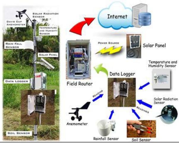
There are already existing FMS installed and maintained by NVSU in the selected municipalities of Nueva Vizcaya. Mainly, the FMS consists of (1) field router, which collects data from the data logger and sends to the server through an Internet connection; (2) data logger, which stores primary data; and (3) weather elements sensors that take measurements of different weather elements at a pre-programmed interval. These sensors include thermometer, rain gauge, solar radiation sensor, soil sensor, wind vane and anemometer.
### b) Instrumentation
The fundamental principle of a monitoring system is to capture data, process it and disseminate results in a systematic way. These monitoring systems enable us to measure trends of various indicators based on the data collected in the field. With our proposed system, different FMSs that were installed will be utilized to gather data as a basis in determining the optimal cropping season of a particular crop in a specific location. These FMS data contain temperature, humidity, soil moisture, wind direction and rain readings.
### c) Data Gathering Procedures
The response of crops to climatic changes is the takeoff point in designing adaptation strategies for crops on climate change that is why it is an imperative and is useful to design adaptation strategies in agriculture like adjustment of cropping calendar, timing of cultural and management activities, and attempts to minimize agricultural damage due to natural calamities. Data monitoring and establishment of climatic patterns in the different micro-climatic zones (MCZs) are essential for localized weather forecasting and development of early warning system for agricultural production. Thus, the modification of existing cropping and farming systems shall be the key to adaptation strategies that will be adopted in the different land utilization types (LUTs).
Cagayan Valley, particularly the province of Nueva Vizcaya has heterogeneous elevation because it is bounded by different mountain systems. This indicates great variability in weather between just small adjacent areas. Using elevation as reference, the province will be mapped and delineated into conceptual MCZs. These MCZs are assumed to have differing weather patterns due to differences in their elevation.
Different FMSs were installed in each of the MCZs. The FMS will then monitor the different weather elements i.e. atmospheric temperature, rainfall, relative humidity, solar radiation, among others. Most importantly, soil data such as soil pH, organic matter, and other chemical properties will be regularly monitored since it is the main element in crop production. The FMS is composed of sensors that collects climate data from the different weather elements and stores it into the data logger. The field router (FR) collects photographs of the current environmental condition and collects the data from the data logger and transmit it to the database server through the use of internet. It is self-sustaining and requires a very minimal user intervention. With these weather elements, software will be developed to interpret and analyze data from the FMS to support decision-making of farmers in their agricultural activities, and for other users such as planners and policy makers in the formulation of adaptation strategies in the local level.
 Fig. 1: The data collection schema of FMS
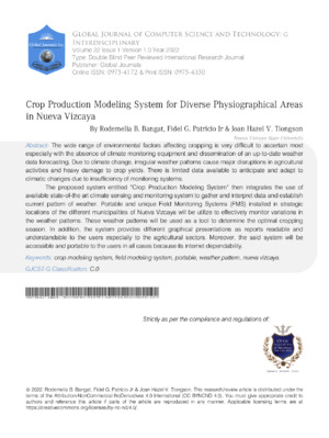
 Fig. 2: The data transmission schema of FMS
The CPMS is dependent on the data coming from the different FMS devices installed in the selected municipalities of Nueva Vizcaya. Data is generated from the weather sensors of the said FMS device. These weather sensor elements include: thermometer, rain gauge, solar radiation sensor, soil sensor, wind vane and anemometer. The following figures then are sample data coming from the FMS device.
<table><tr><td colspan="2">EM29256</td><td>Port 1</td><td>Port 1</td><td>Port 2</td><td>Port 3</td><td>Port 4</td><td>Port 4</td><td>Port 5</td><td>Port 5</td><td>Port 5</td><td></td></tr><tr><td colspan="2">17160 records</td><td>VP-3 Hur</td><td>VP-3 Hur ECRN-10 PYR</td><td colspan="8">Sol: Davis Cu Davis Cu Davis Cu STE MoT STE MoT STE MoT STE MoT STE MoT STE MoT STE MoT STE MoT STE MoT STE MoT STE MoT STE MoT STE MoT STE MoT STE MoT STE MoT STE MoT STE MoT STE MoT STE MoT STE MoT STE MoT STE MoT STE MoT STE MoT STE MoT STE MoT STE MoT STE MoT STE MoT STE MoT STE MoT STE MoT STE MoT</td></tr><tr><td colspan="2">Measurement Time</td><td>RH</td><td>°C Temp mm</td><td>Prec Solar W/m/s</td><td>Winncs m/s</td><td>Gust*</td><td>Directim m/m*</td><td>V/V*</td><td>CTemp S/mC</td><td>ECm</td><td></td></tr><tr><td colspan="2">29 Jun 2015 2.00 PM</td><td>0</td><td>0</td><td>0.0</td><td>0.0</td><td>0.0</td><td>0.0</td><td>0</td><td>0</td><td>0</td><td></td></tr><tr><td colspan="2">30 Jun 2015 11.00 AM</td><td>0</td><td>0</td><td>0.0</td><td>0.0</td><td>0</td><td>0</td><td>0</td><td>0</td><td>0</td><td></td></tr><tr><td colspan="2">30 Jun 2015 12.00 PM</td><td>3.426</td><td>104.0</td><td>0.4</td><td>805.7</td><td>0.9</td><td>1.5</td><td>40</td><td>0.046</td><td>36.8</td><td></td></tr><tr><td colspan="2">30 Jun 2015 1.00 PM</td><td>2.056</td><td>104.0</td><td>0.0</td><td>983.3</td><td>0.9</td><td>1.4</td><td>7</td><td>0.076</td><td>30.8</td><td></td></tr><tr><td colspan="2">30 Jun 2015 2.00 PM</td><td>0.343</td><td>104.0</td><td>0.0</td><td>913.7</td><td>0.8</td><td>1.8</td><td>41</td><td>0.076</td><td>30.4</td><td></td></tr><tr><td colspan="2">30 Jun 2015 3.00 PM</td><td>2.056</td><td>104.0</td><td>0.0</td><td>767.2</td><td>1.0</td><td>1.9</td><td>45</td><td>0.075</td><td>30.3</td><td></td></tr><tr><td colspan="2">30 Jun 2015 4.00 PM</td><td>1.370</td><td>104.0</td><td>0.0</td><td>575.0</td><td>0.8</td><td>1.8</td><td>29</td><td>0.075</td><td>30.2</td><td></td></tr><tr><td colspan="2">30 Jun 2015 5.00 PM</td><td>2.741</td><td>104.0</td><td>0.0</td><td>355.2</td><td>0.6</td><td>1.2</td><td>19</td><td>0.075</td><td>30.3</td><td></td></tr><tr><td colspan="2">30 Jun 2015 6.00 PM</td><td>0.343</td><td>104.0</td><td>0.0</td><td>78.7</td><td>0.5</td><td>2.2</td><td>123</td><td>0.076</td><td>30.4</td><td></td></tr><tr><td colspan="2">30 Jun 2015 7.00 PM</td><td>2.741</td><td>104.0</td><td>0.0</td><td>3.7</td><td>0.6</td><td>2.2</td><td>174</td><td>0.076</td><td>30.5</td><td></td></tr><tr><td colspan="2">30 Jun 2015 8.00 PM</td><td>0.343</td><td>104.0</td><td>0.0</td><td>0.0</td><td>0.2</td><td>0.9</td><td>Chart Title</td><td>0.076</td><td>30.7</td><td></td></tr><tr><td colspan="2">30 Jun 2015 9.00 PM</td><td>0.343</td><td>104.0</td><td>0.0</td><td>0.0</td><td>0.2</td><td>0.6</td><td>195</td><td>0.076</td><td>30.8</td><td></td></tr><tr><td colspan="2">30 Jun 2015 10.00 PM</td><td>0.343</td><td>104.0</td><td>0.0</td><td>0.0</td><td>0.1</td><td>0.5</td><td>218</td><td>0.076</td><td>30.9</td><td></td></tr><tr><td colspan="2">30 Jun 2015 11.00 PM</td><td>0.343</td><td>104.0</td><td>0.0</td><td>0.0</td><td>0.1</td><td>0.5</td><td>221</td><td>0.076</td><td>30.9</td><td></td></tr><tr><td colspan="2">1 Jul 2015 12.00 AM</td><td>0.343</td><td>104.0</td><td>0.0</td><td>0.0</td><td>0.1</td><td>0.6</td><td>245</td><td>0.076</td><td>31.0</td><td></td></tr><tr><td colspan="2">1 Jul 2015 1.00 AM</td><td>0.343</td><td>104.0</td><td>0.0</td><td>0.0</td><td>0.1</td><td>0.4</td><td>272</td><td>0.076</td><td>31.0</td><td></td></tr><tr><td colspan="2">1 Jul 2015 2.00 AM</td><td>0.343</td><td>104.0</td><td>0.0</td><td>0.0</td><td>0.0</td><td>0.4</td><td>261</td><td>0.076</td><td>31.0</td><td></td></tr><tr><td colspan="2">1 Jul 2015 3.00 AM</td><td>0.343</td><td>104.0</td><td>0.0</td><td>0.0</td><td>0.1</td><td>0.6</td><td>255</td><td>0.076</td><td>30.9</td><td></td></tr><tr><td colspan="2">1 Jul 2015 4.00 AM</td><td>0.343</td><td>104.0</td><td>0.0</td><td>0.0</td><td>0.0</td><td>0.3</td><td>255</td><td>0.076</td><td>30.9</td><td></td></tr><tr><td colspan="2">1 Jul 2015 5.00 AM</td><td>0.343</td><td>104.0</td><td>0.0</td><td>0.0</td><td>0.1</td><td>0.4</td><td>255</td><td>0.076</td><td>30.9</td><td></td></tr><tr><td colspan="2">1 Jul 2015 6.00 AM</td><td>1.713</td><td>104.0</td><td>0.0</td><td>5.5</td><td>0.1</td><td>0.5</td><td>255</td><td>0.076</td><td>30.8</td><td></td></tr><tr><td colspan="2">1 Jul 2015 7.00 AM</td><td>0.343</td><td>104.0</td><td>0.0</td><td>159.3</td><td>0.0</td><td>0.4</td><td>271</td><td>0.076</td><td>30.8</td><td></td></tr><tr><td colspan="2">1 Jul 2015 8.00 AM</td><td>0.343</td><td>104.0</td><td>0.0</td><td>408.3</td><td>0.2</td><td>0.8</td><td>71</td><td>0.076</td><td>30.7</td><td></td></tr><tr><td colspan="2">1 Jul 2015 9.00 AM</td><td>1.028</td><td>104.0</td><td>0.0</td><td>635.4</td><td>0.6</td><td>1.8</td><td>26</td><td>0.076</td><td>30.6</td><td></td></tr></table>
Fig. 3: Sample XLS data from the FMS device
This data was created from the FMS device situated at Diadi, Nueva Vizcaya. The recorded data was generated starting June 2015 at an hourly basis as presented in the first column of the table. The succeeding columns are utilized for the ten (10) sensors in an FMS device. Table now shows the different results established by each sensor. It can be noted in the given table that zero ( $\varnothing$ ) values are also recorded. This would mean that a particular sensor loses its signal during data transmission. Another reason would be the physical device is non-functional at all. A picture interpretation of the data collected in each sensor is then provided below for better understanding of the patterns provided by the sensors.
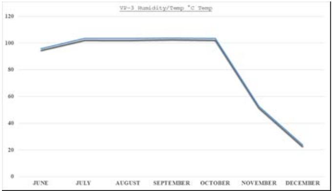 Fig. 4: Sample graph for humidity
The provided graph shows that humidity in the months of June to October is at $100\%$ then slowly going down by the end of October until December. This would mean a cold or rainy season for the months of October to December, which is not suitable for planting palay.
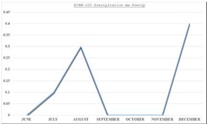 Fig. 5: Sample graph for rain gauge
The graph in Figure 5 shows the amount of rain (water) being measured. It can be observed that by the end of June, no amount of water was recorded as that in the mid of September to mid of November.
## III. RESULTS AND DISCUSSION
Climate change refers to significant changes in global temperature, precipitation, wind patterns and other measures of climate that occur over several decades or longer. These significant changes in the environment contribute a great impact most especially in the agricultural sector. That is why climate change adaptation requires more than simply maintaining the current level of performance from the agricultural sector, but rather developing a set of responses that allow the sector to improve performance under the changing conditions climate change implies. Because agricultural production remains the main source of income for most rural communities, adaptation of the agricultural sector to the adverse effects of climate change will be imperative to protect and improve the livelihoods of every human being. Today, crop production is increasingly vulnerable to risks associated with climate change. This is because climate change is causing variations in environmental conditions that are posing significant challenges to farmers, over and beyond those that are experienced "normally". Even under population pressure and the dwindling productive agricultural areas, crop yields should be maintained still. This explains why the agricultural sector bears one of the heaviest burdens to adapt and mitigate climate change. However, with the availability of the state-of-the-art technology like the FMS and the Crop Production Modeling System, there is a huge potential for crop production practices to adapt to, and contribute to the mitigation of climate change. With this study, different FMSs installed in strategic locations of the province will effectively monitor variations in weather patterns that will be used as a basis in determining the optimal cropping season of a particular crop in a specific location. For easier understanding on the part of the farmers, different reports in graphical presentations and heat maps will be created by the system proposing the optimal crop to plant including the target location. As a result, the interface of the Crop Production Modeling System is provided below for easier understanding.
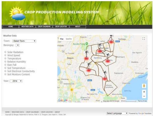 Fig. 6: CPMS Weather Data Screen
As mentioned in this study, six FMSs were installed in the selected municipalities of Nueva Vizcaya namely: Bayombong, Diadi, Dupax del Sur, Kasibu, Kayapa and Santa Fe. The said FMSs consist of (1) field router; (2) data logger; and (3) weather elements sensors that take measurements of different weather elements at a pre-programmed interval.
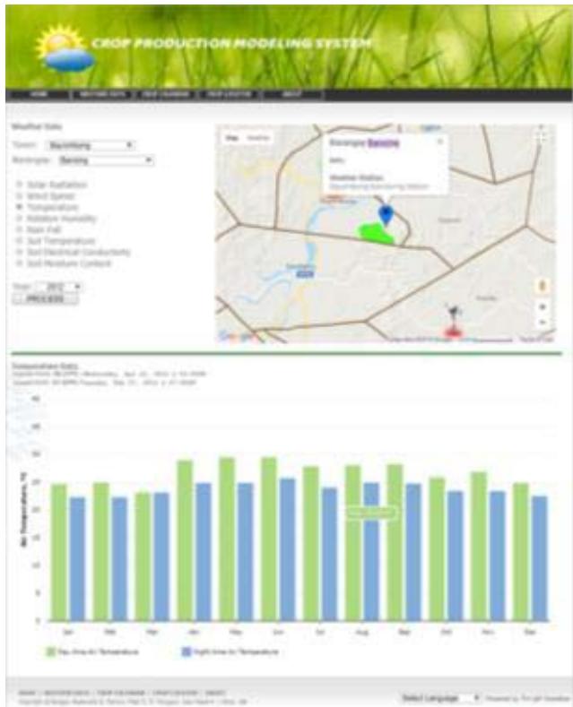 Fig. 7: Weather Data with Graph
This screen shows the graphical representation of the data coming from the sensors of a particular FMS device situated at a strategic location. Data gathered were in CSV or XLS format that will be interpreted/converted in a human readable format like the graph for easier understanding. This report is generated by the system that can be used as one tool in the decision-making process of the farmers.
Fig. 8: Sample XLS data collected from the FMS device
<table><tr><td></td><td>A</td><td>B</td><td>C</td><td>D</td><td>E</td><td>F</td><td>G</td><td>H</td><td>I</td><td>J</td><td>K</td><td></td></tr><tr><td>1</td><td>EM29256</td><td>Port 1</td><td>Port 1</td><td>Port 2</td><td>Port 3</td><td>Port 4</td><td>Port 4</td><td>Port 5</td><td>Port 5</td><td>Port 5</td><td>Port 5</td><td></td></tr><tr><td>2</td><td>17160 records</td><td>VP-3 Hu</td><td>VP-3 Hu ECRN-10 PYR Sol/Davis Cu Davis</td><td colspan="9">Sol/Davis Cu Davis Cu Davis Cu STE MoT STE MoT STE MoT STE MoT STE MoT STE MoT STE MoT STE MoT STE MoT STE MoT STE MoT STE MoT STE MoT STE MoT STE MoT STE MoT STE MoT STE MoT STE MoT STE MoT STE MoT STE MoT STE MoT STE MoT STE MoT STE MoT STE MoT STE MoT STE MoT STE MoT STE MoT STE MoT STE MoT STE MoT</td></tr><tr><td>3</td><td>Measurement Time</td><td>RH</td><td>°C Temp mm</td><td>Prec Solar W/m/s</td><td>W/m/s</td><td>Gust*</td><td>Directicn m/m*</td><td>V/V*</td><td>Temp m/s/cm</td><td colspan="2">E</td><td></td></tr><tr><td>4</td><td>29 Jun 2015 2.00 PM</td><td>0</td><td>0</td><td>0</td><td>0.0</td><td>0.0</td><td>0.0</td><td>0</td><td>0</td><td>0</td><td>0</td><td></td></tr><tr><td>5</td><td>30 Jun 2015 11.00 AM</td><td>0</td><td>0</td><td>0</td><td>0.0</td><td>0</td><td>0</td><td>0</td><td>0</td><td>0</td><td>0</td><td></td></tr><tr><td>6</td><td>30 Jun 2015 12.00 PM</td><td>3.426</td><td>104.0</td><td>0.4</td><td>805.7</td><td>0.9</td><td>1.5</td><td>40</td><td>0.046</td><td>36.8</td><td>0.00</td><td></td></tr><tr><td>7</td><td>30 Jun 2015 1.00 PM</td><td>2.056</td><td>104.0</td><td>0.0</td><td>983.3</td><td>0.9</td><td>1.4</td><td>7</td><td>0.076</td><td>30.8</td><td>0.00</td><td></td></tr><tr><td>8</td><td>30 Jun 2015 2.00 PM</td><td>0.343</td><td>104.0</td><td>0.0</td><td>913.7</td><td>0.8</td><td>1.8</td><td>41</td><td>0.076</td><td>30.4</td><td>0.00</td><td></td></tr><tr><td>9</td><td>30 Jun 2015 3.00 PM</td><td>1.370</td><td>104.0</td><td>0.0</td><td>767.2</td><td>1.0</td><td>1.9</td><td>49</td><td>0.076</td><td>30.3</td><td>0.00</td><td></td></tr><tr><td>10</td><td>30 Jun 2015 4.00 PM</td><td>1.370</td><td>104.0</td><td>0.0</td><td>575.0</td><td>0.8</td><td>1.8</td><td>29</td><td>0.075</td><td>30.2</td><td>0.00</td><td></td></tr><tr><td>11</td><td>30 Jun 2015 5.00 PM</td><td>2.741</td><td>104.0</td><td>0.0</td><td>355.2</td><td>0.6</td><td>1.2</td><td>19</td><td>0.075</td><td>30.3</td><td>0.00</td><td></td></tr><tr><td>12</td><td>30 Jun 2015 6.00 PM</td><td>0.343</td><td>104.0</td><td>0.0</td><td>78.7</td><td>0.5</td><td>2.2</td><td>123</td><td>0.076</td><td>30.4</td><td>0.00</td><td></td></tr><tr><td>13</td><td>30 Jun 2015 7.00 PM</td><td>2.741</td><td>104.0</td><td>0.0</td><td>3.7</td><td>0.6</td><td>2.2</td><td>171</td><td>0.076</td><td>30.5</td><td>0.00</td><td></td></tr><tr><td>14</td><td>30 Jun 2015 8.00 PM</td><td>0.343</td><td>104.0</td><td>0.0</td><td>0.0</td><td>0.2</td><td>0.9</td><td>174</td><td>0.076</td><td>30.7</td><td>0.00</td><td></td></tr><tr><td>15</td><td>30 Jun 2015 9.00 PM</td><td>0.343</td><td>104.0</td><td>0.0</td><td>0.0</td><td>0.2</td><td>0.6</td><td>195</td><td>0.076</td><td>30.8</td><td>0.00</td><td></td></tr><tr><td>16</td><td>30 Jun 2015 10.00 PM</td><td>0.343</td><td>104.0</td><td>0.0</td><td>0.0</td><td>0.1</td><td>0.5</td><td>218</td><td>0.076</td><td>30.9</td><td>0.00</td><td></td></tr><tr><td>17</td><td>30 Jun 2015 11.00 PM</td><td>0.343</td><td>104.0</td><td>0.0</td><td>0.0</td><td>0.1</td><td>0.5</td><td>221</td><td>0.076</td><td>30.9</td><td>0.00</td><td></td></tr><tr><td>18</td><td>1 Jul 2015 12.00 AM</td><td>0.343</td><td>104.0</td><td>0.0</td><td>0.0</td><td>0.1</td><td>0.6</td><td>245</td><td>0.076</td><td>31.0</td><td>0.00</td><td></td></tr><tr><td>19</td><td>1 Jul 2015 1.00 AM</td><td>0.343</td><td>104.0</td><td>0.0</td><td>0.0</td><td>0.1</td><td>0.4</td><td>272</td><td>0.076</td><td>31.0</td><td>0.00</td><td></td></tr><tr><td>20</td><td>1 Jul 2015 2.00 AM</td><td>0.343</td><td>104.0</td><td>0.0</td><td>0.0</td><td>0.0</td><td>0.4</td><td>267</td><td>0.076</td><td>31.0</td><td>0.00</td><td></td></tr><tr><td>21</td><td>1 Jul 2015 3.00 AM</td><td>0.343</td><td>104.0</td><td>0.0</td><td>0.0</td><td>0.1</td><td>0.6</td><td>255</td><td>0.076</td><td>30.9</td><td>0.00</td><td></td></tr><tr><td>22</td><td>1 Jul 2015 4.00 AM</td><td>0.343</td><td>104.0</td><td>0.0</td><td>0.0</td><td>0.0</td><td>0.3</td><td>255</td><td>0.076</td><td>30.9</td><td>0.00</td><td></td></tr><tr><td>23</td><td>1 Jul 2015 5.00 AM</td><td>0.343</td><td>104.0</td><td>0.0</td><td>0.0</td><td>0.1</td><td>0.4</td><td>255</td><td>0.076</td><td>30.9</td><td>0.00</td><td></td></tr><tr><td>24</td><td>1 Jul 2015 6.00 AM</td><td>1.713</td><td>104.0</td><td>0.0</td><td>5.5</td><td>0.1</td><td>0.5</td><td>255</td><td>0.076</td><td>30.8</td><td>0.00</td><td></td></tr><tr><td>25</td><td>1 Jul 2015 7.00 AM</td><td>0.343</td><td>104.0</td><td>0.0</td><td>159.3</td><td>0.0</td><td>0.4</td><td>271</td><td>0.076</td><td>30.8</td><td>0.00</td><td></td></tr><tr><td>26</td><td>1 Jul 2015 8.00 AM</td><td>0.343</td><td>104.0</td><td>0.0</td><td>408.3</td><td>0.2</td><td>0.8</td><td>71</td><td>0.076</td><td>30.7</td><td>0.00</td><td></td></tr><tr><td>27</td><td>1 Jul 2015 9.00 AM</td><td>1.028</td><td>104.0</td><td>0.0</td><td>635.4</td><td>0.6</td><td>1.8</td><td>26</td><td>0.076</td><td>30.6</td><td>0.00</td><td></td></tr></table>
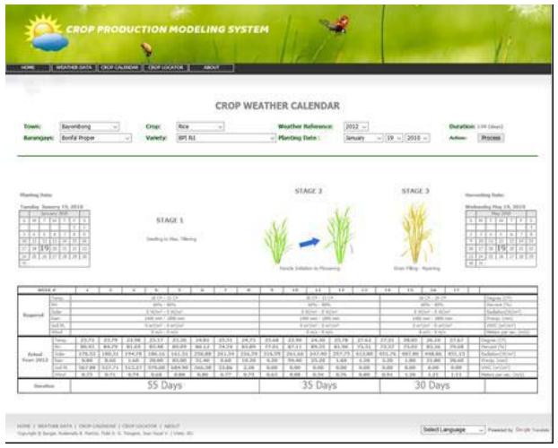 Fig. 9: Crop Weather Calendar
The above picture is also a system generated report that shows a pattern of growth of a particular crop in a particular location. This will be of great help to the farmers because specific calendar dates are provided to determine the optimal cropping season. Also, the patterns of data gathered from the FMS device are presented in this report to serve as a tool for the farmers to decide in their next cropping endeavor.
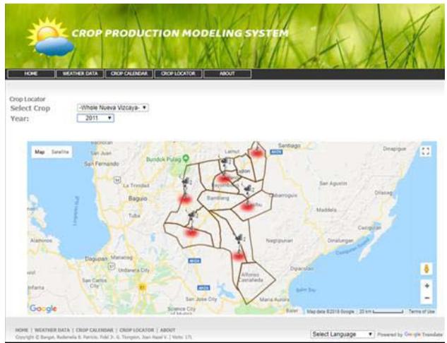 Fig. 10: Heat Map of Nueva Vizcaya
This figure presents the map of Nueva Vizcaya containing the selected municipalities where the different FMS devices are situated. This part of the system then serves as a reference for the farmer on what particular crop gave the best production in a particular year given the data coming from the FMS device. Also, with this report, farmers now can decide what crop to plant and when to plant in order to obtain the optimal harvest.
## IV. CONCLUSIONS
In conclusion, the developed portable, mobile, and easy to maintain internet-based weather monitoring system is useful to establish weather differences in Nueva Vizcaya. This system allows small spatial scale weather databases which could be transformed into usable data essential to create a localized climate change adaptation strategy for agriculture in Nueva Vizcaya. Also, the data parsing software (FMS parser) written allows the FMS raw data to be interpreted and translated into forms usable by intended users and beneficiaries of information.
## ACKNOWLEDGMENTS
We give credit to Dr. Maria Visitation N. Gumabay who pushed us with this piece of work.
Generating HTML Viewer...
References
11 Cites in Article
Wilfredo Dumale,Masaru Mizoguchi (2013). Potential applications of the field monitoring system (FMS) for local and farmer-level climate change adaptation in agriculture.
Changsun Shin*,A Rahman*,Myeongbae Lee,Jangwoo Park,Yongyun Cho (2010). Identifying High Significance Input Factors in Strawberry Production using Linear Model.
Et Imtinungla (2017). Embedded System based Agricultural Field Monitoring System.
Aykut Sevim (2004). Expert Systems in Agriculture.
Johann Strauss (2022). Economic and yield comparisons of different crop and crop-pasture production systems..
Ani Dath (2013). Development of an Expert System for Agricultural Commodities.
Ian Clark (2009). Naming sites: Names as management tools in indigenous tourism sites – An Australian case study.
A Soja,G Soja (2007). Effects of weather conditions on agricultural crop production in Austria between 1869 and 2003.
S Nandurkar,V Thool,R Thool Design and Development of Precision Agriculture System Using Wireless Sensor Network.
Et Sun Shin (2009). Development of Field Monitoring Server System and Its Application in Agriculture.
K Vining (2007). Effects of Weather on Agricultural Crops and Livestock: An Overview.
No ethics committee approval was required for this article type.
Data Availability
Not applicable for this article.
How to Cite This Article
Fidel G. Patricio. 2026. \u201cCrop Production Modeling System for Diverse Physiographical Areas in Nueva Vizcaya\u201d. Global Journal of Computer Science and Technology - G: Interdisciplinary GJCST-G Volume 22 (GJCST Volume 22 Issue G1).
Explore published articles in an immersive Augmented Reality environment. Our platform converts research papers into interactive 3D books, allowing readers to view and interact with content using AR and VR compatible devices.
Your published article is automatically converted into a realistic 3D book. Flip through pages and read research papers in a more engaging and interactive format.
Our website is actively being updated, and changes may occur frequently. Please clear your browser cache if needed. For feedback or error reporting, please email [email protected]
Thank you for connecting with us. We will respond to you shortly.