## I. INTRODUCTION
The traffic performance of a roadway network is greatly influenced by the traffic flow through intersections. Many types of traffic control are being used worldwide at intersections such as yield signs, stop signs, roundabouts and signals. Similar to other countries, many traffic signals are installed in Jordan at intersections with moderate and heavy traffic volumes.
Traffic signals ensure safe and efficient traffic flow at intersections, along routes, and in street networks. They improve intersection capacity, minimize traffic delays, enhance safety by reducing specific accidents like right-angle collisions, promote orderly traffic movements, allow safe passage for minor amidst heavy traffic, and aid in establishing a signal system. Transportation professionals primarily measure the performance of signalized intersections based on vehicle delay, a crucial parameter (David 2013).
Vehicle delay is the most important parameter used by transportation professionals in evaluating the performance of a signalized intersection. This is perhaps because it directly relates to the time loss that a vehicle experiences while crossing an intersection (though we have not considered other problems like congestion due to queuing, extra fuel loss due to vehicle ignition etc.) Determining delay at intersections is challenging due to the unpredictable nature of arrival and departure processes. However, extensive research has been conducted to define delay using various analytical models, including deterministic queuing, steady state stochastic, and time dependent stochastic models. These models make assumptions that simplify the complex flow conditions, providing an approximate measure of the average delay experienced by vehicles crossing an intersection. Some studies have also aimed to predict the variance in overall delay for individual vehicles, considering the significant variations and randomness in traffic arrivals and interruptions caused by traffic signal controls (Gupta, 2005).
Vehicles exert a substantial environmental influence through emissions and the consumption of fossil fuels. The burning of gasoline and diesel generates CO2, a greenhouse gas that contributes to climate change. Additionally, vehicles release pollutants like NOx and particulate matter, negatively impacting both air quality and human health. The extraction, refining, and transportation of fossil fuels also lead to habitat destruction and water pollution. To address these issues, there is a strong focus on developing electric vehicles, enhancing fuel efficiency, and investing in alternative transportation options such as public transit and cycling infrastructure. These measures are essential for reducing emissions, improving air quality, and safeguarding the environment for future generations.
### a) Project Description
Yajouz road is located in Amman, and it is considered one of the most important dynamic sites which links Amman and Zarqa. In a map is displayed which demonstrates the location of Yajouz road within the districts of Amman.
In this study, a part of the Yajouz road is considered which is Al Jubaiha intersection. The intersection has four legs and connects Yajoz street with Abdullah Al-Lawzi Street. The intersection is signalized, and it is selected because it is considered one of the most important dynamic sites. Jubaiha Intersection has a heavy daily volume of traffic, which leads to a traffic problem represented by delay, especially during peak hours. It is located in the north of the Jordanian capital.
 Fig. 1: Aljbaha intersection
### b) Problem Statement
The increase in road network by widening roads, building new tunnels and other infrastructure is costly and limited by the available spaces in Amman, therefore, the other solution is to decrease the travel demand, especially within the peak hours. The long-term solution requires developing a reliable and comprehensive transportation system and encouraging people to use it instead of private cars. However, the current situation of congested traffic requires immediate solutions with minimal costs, time, and effort. In this project, a micro-scale solution to the delay problem at the intersection is proposed. More than one alternative will be considered (including a signal optimization, median U-Turn and signal optimization with median U-turn), and then the best alternative will be selected. Although, a long-term macro scale solution is required on a network-wide level which considers the interactions between different elements of the roadway. However, the scope of this project is limited to a micro-scale solution.
### c) Project Objectives
This project aims to improve the level of service at Al-Jbeiha intersection. The objectives can be summarized as follows:
1. Assessing the existing level of service at the intersection: Evaluate the current traffic conditions and determine the performance of the intersection.
2. Developing alternative solutions for improved traffic conditions: Propose various strategies and measures that can enhance the traffic flow and alleviate congestion at the intersection. Use simulation models to estimate the resulting level of service for each alternative.
3. Selecting the optimal solution: Analyze and compare the proposed alternatives based on their predicted level of service and feasibility. Determine the best alternative for implementation at the intersection.
### d) Project Constrains
The main constraints involved in this project are economic and ethical. First, the selected alternative should be economically justified by considering a sequential evaluation process starting from the least disruptive option to the most disruptive option which would be more costly. Furthermore, the design follows all local and international ethical code requirements.
### e) Project Standard and Codes
- Highway Capacity Manual) HCM)
- American Association of State Highway and Transportation Officials (AASHTO) 2011
## II. LITERATURE REVIEW
Hussein (2023) conducted a study to evaluate and enhance four three-leg intersections controlled by STOP signs in various locations within Amman City. The evaluation and improvement processes utilized Highway Capacity Software (HCS-2010) and Synchro-10 software. The validation and simulation were performed using VISSIM-11 software. The evaluation with HCS-2010 and Synchro-10 indicated that the left-turn movements from the minor streets experienced significant delays and operated in a breakdown traffic condition (Level of Service LOS-F). The application of Warrant-3 (Peak Hour Volume) determined that three of the selected intersections warranted signalization under existing conditions, while the fourth intersection did not meet the requirements. For short-term conditions with a growth rate of $5.5\%$, both software tools indicated that all four selected intersections warranted traffic signals. The optimal cycle length for the traffic signals was determined for each intersection, considering two operation modes for the left-turn movements on the major streets: Protected and Protected-Permitted phase. The HCS-2010 and Synchro-10 software were used for this analysis, and the results were validated using VISSIM-11. The improvements in traffic and geometric conditions resulted in a reduction in vehicle delays, with improved Level of Service (LOS-C or LOS-D) at the minor approaches and the entire selected intersections (LOS-B or LOS-C).
In their study, Khalifate (2021) aimed to improve the capacity and level of service at the sixth circle in Jordan by implementing traffic signals and a roundabout metering approach. The VISSIM software and a $\mathrm{C + + }$ program were utilized for this purpose. The sixth circle, situated near Crown Plaza and the Jordan Gate Towers project, experiences congestion due to heavy traffic flow. The study focused on assessing the traffic situation at the sixth circle and proposed potential solutions to reduce daily traffic flow for circle users. In the second scenario, four signals were placed at the roundabout, interconnected with different cycle lengths. A 90-second cycle length resulted in a level of service

rating of D. The third scenario involved the use of adaptive signals on the roundabout, which were connected to ground detectors placed before the signals. These adaptive signals operated based on the queue length of approaching vehicles detected by the ground detectors. The opening and closing of the signals were designed using simulation and implemented through the $\mathrm{C}++$ programming language. The first two signals were opened for 45 seconds, prioritizing Swefieh road with reference to King Faisal, and then closed for 45 seconds to open the signal for the next street from the fifth circle, specifically Zahrain street.
## III. METHODOLOGY
The methodology is summarized as follows:
1) Collecting data for the intersection; traffic volumes, geometric components, and traffic signal system.
2) Analysis of the current situation for the intersection, by finding the level of service and delay for the intersection using the Synchro software.
3) Provide solutions for the intersection.
4) Evaluate the performance of the intersection after applying the solutions, in term of level of service and delay, with the help of the Synchro software.
### a) Traffic Volumes
- Aljbaha intersection located at the Amman, the key traffic data were taken from the department of traffic operations at GAM. Traffic data was collected on April 4th, 2022, with attention to the 15-min peak hour volumes that happened in the morning peak from 7-8 am.
b) Model Development
SYNCHRO8 which is a microscopic level analysis software was used to analyze and evaluate.
## i. Current Situation
The current Volumes of the current Volumes values Based on the analysis of data above, the total intersection control delay was found to be 62.1 seconds, under those circumstances the level of service was E. Moreover, the maximum volume to capacity ratio (V/C) was 1.94.
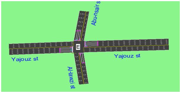
Fig. 2: Level of service
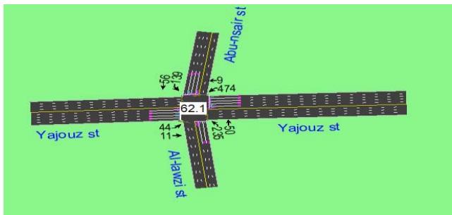 Fig. 3: The total intersection delays
## IV. PROJECT DESIGN
The main objective of this paper is to design Al-jubha intersection and the Roadways approaches optimized to better level of service.
Traffic design for this intersection include evaluation the current LOS for the intersection and design all possible solutions to reduce congestion, delay and low level of service using Synchro 8.
### a) Signal Optimization: (The FIRST Alternative)
Traffic signal optimization is one of the most cost-effective ways to improve traffic movement and make our streets safe and efficient. Signal optimization is performed for the following reasons: To adjust signal timing to account for changes in traffic patterns due to new developments and traffic growth.
LOS (D) Steady Traffic at High Density. The speed and the maneuverability are severely reduced. Low level of comfort for drivers, as collisions with other vehicles, must constantly be avoided. A slight increase in the traffic risks causing some operational problems and saturating the network.
Under the same phasing and geometric conditions, Synchro 8 results show that the cycle length has decrease to 45 seconds. Furthermore, the total intersection delay has decreased to 48.8 seconds, and the maximum volume to capacity ratio has decrease to 1.8. However, the service level turned into D.
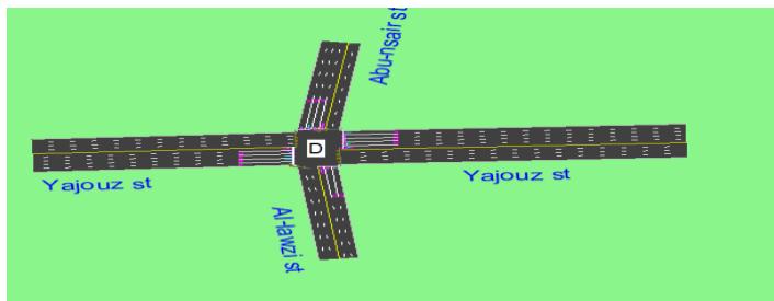
Fig. 4: Level of service
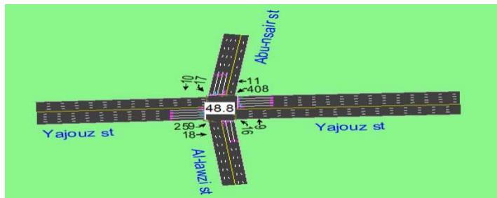 Fig. 5: The total intersection delays
### b) Median U-Turn (The Second Alternative)
Median U-Turn: The main disadvantage is the added stopping and delay impact on left turning traffic. Although despite this fact, this design has been shown to improve total intersection delay and travel time conditions under certain volumes. It requires larger R.O.W. along the major roadway $\neg$ AASHTO recommends a 60ft to accommodate large trucks, from a non-motorized user standpoint, this design presents fewer threats to crossing pedestrians (longer time, refuge area). Level of service LOS (C) Steady Traffic but Limited. The presence of other vehicles affects drivers. The choice of the speed is affected and maneuvering requires vigilance. The level of comfort decreases quickly at this level, because drivers have a growing.
Fig. 6: Level of service
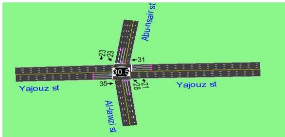 Fig. 7: The total intersection delays
### c) Signal Optimization a Median U-turn (Third Alternative)
LOS (B) Steady Traffic: The presence of other vehicles begins to affect the behavior of individual drivers. The choice of the speed is free, but the maneuverability has somewhat decreased. The comfort is excellent, as drivers simply need to keep an eye on nearby vehicles. Intersection delays 11.8s.
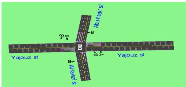
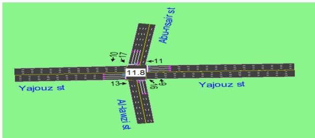
Fig. 8: Level of service

Fig. 9: The total intersection delays

## V. RESULTS
Table 1: Summary of result
<table><tr><td></td><td>Cycle length</td><td>Maximum v/c ratio</td><td>Intersection delay</td><td>Level of service</td></tr><tr><td>Current situation</td><td>158</td><td>1.94</td><td>62.1</td><td>E</td></tr><tr><td>Signal optimization</td><td>45</td><td>1.8</td><td>48.8</td><td>D</td></tr><tr><td>Median U-turn</td><td>158</td><td>0.61</td><td>30.5</td><td>C</td></tr><tr><td>Signal optimization +Median U-turn</td><td>45</td><td>0.67</td><td>11.8</td><td>B</td></tr></table>
## VI. CONCLUSION
1. The main object of this study is to evaluate the effect of implementing unconventional arterial intersection design.
2. These designs are regarded to be unconventional because they incorporate geometric features or movement restriction that would be accepted at 4 leg intersection.
3. Aljbaha intersection was selected to perform this study. In the final analysis, results showed a different level of improvement according to the UAID model chosen, to sum up, the level of service of Signal optimization, median U-turn and single optimization + median U-turn enhanced from E to D, C, B respectively. Moreover, the intersection delay was reduced by 48.8, 30.5, and 11.8 respectively.
4. Since the median U-turn + single optimization which improved the LOS from E to B on the main intersection the use of median U-turn + single optimization will decrease the delay by $11.8\%$.
Generating HTML Viewer...
References
7 Cites in Article
Taqwa Hadidi,Hana Naghawi,Khair Jadaan (2022). Unconventional Intersection Designs for Improving Traffic Operation Along Arterial Roads.
H Naghawi (2014). Analyzing delay and queue length using microscopic simulation for the unconventional intersection design Superstreet.
H Naghawi,A Alsoud,T Alhadidi (2018). The possibility for implementing the superstreet unconventional intersection design in Jordan.
R Savithramma,R Sumathi,H Sudhira (2005). SMART Emergency Vehicle Management at Signalized Intersection using Machine Learning.
A Hussein,B Jrew (2023). Evaluation and Improvement of Three-Leg Intersections: A Case Study in Amman City.
Ibrahim Khliefat,Mohammed Naser,Fadi Alhomaidat,Shadi Hanandeh (1979). Improving the Capacity and Level of Service at the Sixth Circle in Jordan by Using Traffic Signals and Roundabout Metering Approach.
C Papacostas,P Prevedonros (2008). Transportation Engineering and Planning.
No ethics committee approval was required for this article type.
Data Availability
Not applicable for this article.
How to Cite This Article
Batool Alaraj. 2026. \u201cEvaluation and Design of Improvement of Al-Jbeiha Signalized Intersection Traffic Operation\u201d. Global Journal of Research in Engineering - E: Civil & Structural GJRE-E Volume 24 (GJRE Volume 24 Issue E1): .
Explore published articles in an immersive Augmented Reality environment. Our platform converts research papers into interactive 3D books, allowing readers to view and interact with content using AR and VR compatible devices.
Your published article is automatically converted into a realistic 3D book. Flip through pages and read research papers in a more engaging and interactive format.
Our website is actively being updated, and changes may occur frequently. Please clear your browser cache if needed. For feedback or error reporting, please email [email protected]
Thank you for connecting with us. We will respond to you shortly.