Five Decades of Hydrological, Vegetation and Biodiversity Responses to Climate Change in a Southwestern Australian Jarrah ( Eucalyptus marginata) forest (1972-2024)
## I. INTRODUCTION
The jarrah (Eucalyptus marginata) forest now covers about two million hectares, located in the extreme south-west of Western Australia. This region has a "Mediterranean-type" climate with hot, dry summers and cooler, wet winters. Rain is brought by a series of low and high pressure systems that travel along a band of latitude know as the "roaring forties". During winter these move closer to the equator and bring the rain.
Every summer there is potential for severe bushfires to occur. This risk is mitigated by a program of prescribed burning that aims to cover between 150000 and 200000 hectares annually. This program aims to keep $45\%$ of the forest with a fuel load that is less than six years old. Low fuels are much easier and safer to control with ground attack crews.
Jarrah trees may live some 350 years and are very resistant to fire, with multiple epicormic shoots on the stem and branches which are protected by a thick bark as well as a lignotuberous seedling stage (Abbott and Loneragan 1986).
The predominant soil is an ancient, deeply weathered (30 meters) and infertile lateritic profile. Where streams have cut into the underlying granite the soils are slightly more fertile, comprising of red and yellow earths with lateritic gravel (Churchward and Batini 1975).
Remarkably, this infertile site carries a magnificent Eucalypt forest over 30 meters in height, predominantly of jarrah (E.marginata), a beautiful re-colored timber which is highly versatile in use and resistant to termites. The forest has high carbon storage (up to $600\mathrm{m}3/\mathrm{ha}$ ) but low productivity $(<2\mathrm{m}3/\mathrm{ha})$. Timber production commenced soon after settlement by Europeans in 1829 and large quantities were harvested for local use and export, especially between 1880 and 1970. Commercial timber harvesting ceased in 2023, the Government claiming concerns about Climate Change as the reason.
Substantial reductions in rainfall in the southwest forests have been linked by academics, the media and environmental groups to rising levels of carbon dioxide in the atmosphere (Batini 2025). The Forest Management Plan (2024-2033) identifies that Climate Change "will be a persistent, escalating stressor on all ecosystems in the planning area". Detailed and expensive monitoring of ecosystem health is now being implemented. However evaluating the effects of a changing climate on a forested ecosystem will require decades of data collection before any significant trends emerge. An alternative approach adopted in this paper is to compare the current situation with data collected in the past.
The catchment of the 2000 ha 31 Mile Brook allows such a comparison, since excellent baseline data for vegetation and stream flow are available from 1972. The Brook is located 50 kms south-east of Perth and a short distance downstream, at Canning dam, the rainfall average in the 1970's was 1290 mm. In 2006 the gauging and rainfall stations were re-opened and an extensive program of research into the effects of changing climate on hydrology, vegetation health and biodiversity commenced. The premise was that the effects would be negative in direction and significant in scale.
Jarrah is the dominant eucalypt, interspersed with marri (Corymbia calophylla) on more fertile soils and blackbutt (E.patens) and bullich (E. megacarpa) growing on water-gaining sites. A detailed description of the vegetation complexes is provided by Havel (1975b). This is a regrowth forest, basal area 25m2/ha, that has been selectively harvested for timber and then regenerated on at least three occasions.
## II. HYDROLOGY
Rainfall from 1880 at Jarrahdale, 15 kms away, show a cyclical dry-wet-dry cycle from 1880-1914, 1915-1965 and 1965 to present (1100 mm, 1251 mm and 1054 mm, Fig 1). Very high rainfall years were: 1915, 1917, 1945, 1946, 1963, 1964 and 1967. These replenished the groundwater and filled the dams,
 Figure 1: Jarrahdale Rainfall (32.3342 S, 116.0755 E, 240m ASL). Bureau of Meteorology rainfall data at Jarrahdale since 1882. (Michael J Freeman)
At 31 Mile Brook the flows are highly variable, ranging from $236\mathrm{mm}$ in the 1970s to $96\mathrm{mm}$ in 2009 after three good years of rainfall, to only $4\mathrm{mm}$ in the 2010 drought year (Silberstein et al 2011).
The forest has continued to transpire drawing on soil-water and groundwater reserves. This has led to a major decline in groundwater levels since the 1970s. Simulations by Croton et al (2012) show a fall of several meters (Fig 2). Eventually the groundwater became disconnected with the stream leading to a marked reduction in both winter discharge and summer baseflow.
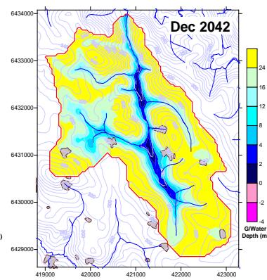 Figure 2: Simulated depth to groundwater (Croton et al 2011)
## III. FOREST COVER
Trends in forest canopy cover between 1989 and 2007 were analysed by Landsat imagery (Wallace et al. 2009). The western, higher rainfall zone was either a stable or increased cover. In contrast, the drier, eastern forests showed a widespread reduction in canopy cover.
CSIRO also measured a Landsat derived leaf area index in 31 Mile Brook between 2004 and 2011 (Silberstein et al 2011). Data show a gradual increase in cover from 2007 to 2009 (by 70 percent, to LAI of 1.5) after three years of good rainfall. Following the drought in 2010, cover fell by 21 percent, indicating a rapid capacity to adjust to prevailing conditions.
## IV. CATCHMENT MODELLING
The catchment model (WEC-C) was specifically designed for the jarrah forest (Croton et al 2011). Modelling showed that annual stream flow in 31 Mile Brook was correlated (0.91) to the total inflow for all catchments that comprise the Integrated Water Supply System. This Brook can be considered as being representative of catchments in the higher rainfall areas.
Comparisons of observed and modelled results were made between 1986 and 2011. There was a good match of data and the model was able to follow the drying trend in both stream flow (from $200\mathrm{mm}$ to $50\mathrm{mm}$ ) and in flow days (from 350 to 170 days). The decrease in soil water storage was calculated as $1100\mathrm{mm}$. In the early 1970's extensive areas of the valley floor had positive heads above the soil surface but by 2010 the groundwater contact with the surface was limited (Fig 2).
CSIRO used TOPOG and canopy data based on an index derived from Landsat (Silberstein et al 2011). This model also produced a good match between observed and predicted results for stream flow, groundwater and soil storage. The model was used to estimate the proportion of reduction in flow due to lower rainfall (about 2/3) and to increased forest cover (about 1/3).
## V. SIMULATIONS OF THINNING TREATMENTS (WEC-C)
Simulations: Thinning treatments ranging from Leaf area values of 0.4, 0.6, 0.8, 1.0 and 1.25 (the untreated control) were used to understand the management regimes required to recover groundwater and stream flow (Croton et al 2011). An annual rainfall of $958\mathrm{mm}$ (the average rainfall for the years 2001 to 2010) was then applied in sequence for five times, to 2060. Sensitivity analyses using different rainfall levels and sequences are possible but were not done.
Results: The untreated scenario caused the groundwater to become completely disconnected from the stream zone. The resulting flows were calculated as 40 mm in 2020, decreasing to 28 mm in 2060. As a comparison the catchment yielded an average of 236mm in the 1970s and 74 mm from 2001-2010.
If a thinning treatment to a leaf area of 0.8 (basal area 14) were done, stream flow would be maintained at $75\mathrm{mm}$, flow-days would increase over the control by 90 days and soil storage by $1250\mathrm{mm}$. Thinning to a lower LAI of 0.4 or 0.6 would increase stream flow and storage even further.
Discussion: Thinning of over-stocked stands increases the growth rate and health of the retained trees by reducing competition for water and nutrients. Interception is reduced, soil moisture increased, the overall evapotranspiration is lowered but evaporation from bare soil is raised. If the area that is thinned is large, the watertable will rise and stream flow increase. The results obtained in the modeling are consistent with these well-established hydrological processes.
## VI. CATCHMENT WATER BALANCE
Macfarlane et al (2011) reported on their water balance studies from 2004-2010, and this work is also included in Silberstein et al (2011). The annual interception was calculated as $13\%$, the over storey transpiration as $45\%$ and the evaporation from understorey and bare ground as $42\%$, totaling $948~\mathrm{mm}$.
During this period, the mean annual rainfall was 947 mm, which included two drought years, 748 mm in 2006 and 524 mm in 2010. The catchment moisture storage decreased by 63 mm on average, or 441 mm in total. Mean runoff was 61 mm, about six percent of rainfall, mostly coming out of storage.
Macfarlane also compared the water use of large trees versus smaller trees. Though sap-flow rates were similar, the water use in larger trees was about half that of smaller trees. This is due to the much larger sapwood area in smaller trees (for any given basal area), as well as a higher crown cover and leaf area. In regrowth forest the evapotranspiration from the overstorey /unit Leaf Area Index (LAI) was about 310 mm.
## VII. ENVIRONMENTAL VALUES
The observed changes in rainfall, water tables, soil moisture storage and stream flow from 1880 to 2024 would be expected to have significant effects on forest health and biodiversity.
Drought In May 2011 there was crown scorch and some drought deaths associated with shallow soils adjacent to exposures of country rock. There was abundant excision of leaves and even large branches, up to $3\mathrm{cm}$ in diameter. Marri was more resistant to drought than jarrah, and there was minimal effect on under storey species. Scorch was again observed in 2024.
Waterlogging Jarrah trees are susceptible to both water logging and Phytophthora disease (Davison and Tay 1987), whereas marri, black butt and bullich are tolerant to infection and thrive on wetter sites. Excessive rainfall between 1915 and 1965, (Fig 1), the associated water logging (Fig 2), combined with Phytophthora disease impacted about $12\%$ of the catchment area (Havel 1975 b). Sites where jarrah was killed were then colonized by the other three eucalypt species. Water logging has had a much greater environmental impact on both jarrah and under storey species than the drought deaths observed since 2011.
Vegetation Comprehensive mapping of the tree statum, of shrub species in the understorey, of site-vegetation complexes, soils, dieback, altitude, slope and rock surfaces was published in 1975 by Havel, with field work carried out some years earlier. Five hundred vegetation plots were set up on a $400\mathrm{m}\times 100\mathrm{m}$ grid and on each plot of $40\mathrm{m}\times 40\mathrm{m}$ all trees greater than $7.5\mathrm{cm}$ at breast height were measured. Within each larger plot, sixteen quadrats each of one square meter were selected and the cover contribution of each perennial species was estimated.
Based on previous studies, 55 species were selected as good indicators of site. For field mapping the vegetation continuum was split into 14 segments, based on the indicator species and the underlying environmental conditions. These were then mapped using both the field data and aerial photos. This extensive study provides an excellent baseline.
Forty years later, 480 of the sites were used to re-measure the tree stratum, the shrub cover and to remap the site-vegetation complexes (Mattiske 2012). Recorded in this survey were 242 vascular plant taxa, from 124 genera and 48 families.
When the two maps were overlaid, localised shifts in classification were noted in some heads of gullies and adjacent to rock surfaces. Overall there was excellent agreement between the two maps:
<table><tr><td>Type</td><td>Location</td><td>Area 1972</td><td>Area 2012</td><td>Percent</td></tr><tr><td>S and P</td><td>Crests/slopes</td><td>Havel 1477 ha</td><td>Mattiske 1490 ha</td><td>79</td></tr><tr><td>C,D,W,Q</td><td>Water-gaining</td><td>Havel 350 ha</td><td>Mattiske 343 ha</td><td>18</td></tr><tr><td>R and G</td><td>Exposed rock</td><td>Havel 58 ha</td><td>Mattiske 56 ha</td><td>3</td></tr></table>
A comparison was also made on abundance for both tree and understorey species. Some species that prefer moister soil conditions, for example black butt, bullich and the shrub Hypocalymna angustifolium, were slightly less abundant in 2012, indicating a small xeric shift. Scorch and some tree deaths were recorded on shallow soils, especially near exposures of rock. There was no widespread collapse of streamside vegetation.
Road reconnaissance by me in 2021 and 2024 along several tracks confirmed that the both the tree and understorey strata in 31 Mile Brook catchment were still healthy. The site had been prescribed burnt in 2017 and some patch death of bullich were seen where the heat was more intense. In these patches the native legume albizia (Paraserianthes lophantha) had regenerated vigorously. This short-lived species will eventually be replaced by swamp peppermint or tea tree (Taxandia linearifolia, previously Agonis linerifolia).
Terrestrial biodiversity The dense streamside vegetation provides excellent cover, protection from predation and food sources for a range of native marsupials, mammals and birds, including the endangered red-eared firetail (Emblema oculata), golden whistler(Pachycephala pectoralis fuliginosa) and white-breasted robin(Eopsaltria georgiana) (Johnstone and Kirkby 2009) and also the quokka (Setonyx brachyurus), quenda(Isoodon obesus), chuditch (Dasyurus geoffroi) and rakali(Hydromys chrysogaster) (Dundas et al 2011).
In addition seed-eating birds such as the forest red-tailed black cockatoo (Calyptorhynchus banksii naso) and the bronzewing pigeon (Phaps chaleoptera) require regular access to water. From 2010 to 2011 a viable population of the mainland quokka was being studied by S. Dundas using monthly trapping and fixed cameras.
Swamp systems at the terminal end of tributaries (gully heads) are the most likely places where changes in occupancy by native species may occur as the result of loss of habitat. A key feature is the maintenance of the quality of this habitat, with a mosaic of fire ages preferred, so as to provide both adequate cover and food source. As the observed shifts in streamside understorey vegetation have been minor, the impact on key terrestrial fauna and birds to date is considered as minimal.
Aquatic biodiversity Comparisons between 1984 and 2010 show that similarity in assemblages has recently shifted by up to 10 percent as the stream has become increasingly seasonal and longer lifecycles cannot be completed. Macroinvertebrates play a vital role in freshwater food webs (Davies and Storey 2012).
The distribution of freshwater species will become increasingly restricted, including species such as Gondwanic dragonflies, stoneflies, freshwater snail, crustaceans and mussels. Breeding habitat for frogs and native fish will also be reduced.
## VIII. DISCUSSION
Water is a key driver for many ecosystem processes. The integration of various sets of discrete data for the 31 Mile Brook catchment allows an holistic evaluation of this ecosystem's response to changes in forest structure as well as a major reduction in rainfall over the past 50 years. As a consequence groundwater levels have fallen, the soil storage has decreased and stream flow is markedly lower. It is estimated that about 65 percent of the change is due to reduced rainfall and that 35 percent to higher transpiration rates in smaller trees.
Vegetation Dynamics: Crown cover has shown an ability to respond quickly and substantially to annual rainfall, increasing in wet years and shedding leaves and larger branches during drought. Despite the overall reduction in rainfall, the long-term trend in this catchment has been to increase its crown cover, the opposite of what was expected. This may be due, in part, to enhanced photosynthesis as a result of increased levels of carbon dioxide in the atmosphere.
Hydrology: The forest is transpiring or evaporating all of each year's rainfall, drawing down on its moisture store, and it is unclear for how long this can continue. The water loss from understorey and bare ground is a significant component of the total loss. Regular prescribed burning is practiced on a 10-12 year cycle. This reduces evapo-transpiration from the understorey but increases evaporation from bare ground. Thinning of the tree stratum requires regular control of coppice from the cut stumps.
Ecological effects: The observed changes to rainfall, water tables, soil moisture storage and stream flow over such a long period of time would be expected to have significant effects on forest health and biodiversity. Only few tree deaths have been observed on shallower soils and occasionally on moister sites. While the death of some trees may be regrettable, the vegetation adjacent to stream lines has not collapsed, but has shown a small xeric shift in some gully-head sites. The dense understorey on which mammals and birds depend is still healthy and any impacts to fauna are considered as minor. A few aquatic species with longer life cycles are occasionally unable to reproduce.
### a) Management Implications
Resilience: Since 1880, the jarrah forest has shown a high level of resilience and any tree deaths are natural changes as the result of multi-decadal cycles that may be wetter or drier than average (Batini 2025). The current dry period in certainly not "unprecedented". Rainfall records (Fig 1) and tree ring studies of karri (E. diversicolor) and Callitris show that the $19^{\text{th}}$ Century (when carbon dioxide levels were low) was much drier than the present and that the $20^{\text{th}}$ Century (as carbon dioxide levels were rising) was the wettest on record (Oliver 2023, O'Donnell et al 2021).
Bushfire management: A high intensity bushfire will have a much greater negative and longer-term impact on vegetation, water quality and fauna (Figure 3). Regular prescribed burning that results in patchy burns of varying intensity, followed up by baiting for predator control is recommended.
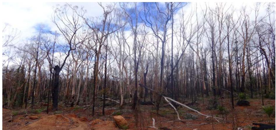 Figure 3: A Bullich wetland near Willowdale devastated by the Yarloop bushfire. Trees, understorey and fauna species were killed over thousands of hectares. Habitat was destroyed for several years (F Batini, March 2016)
Thinning for ecosystem health: The modelling carried out by Croton Consulting matched observed data and gives confidence that the predictions made about management options would be reasonably accurate. These showed that regular thinning to a leaf area of 0.8 (basal area of 14) together with coppice control could maintain stream flows at the 2000-2010 levels, which is encouraging. However thinning is expensive and will only be done on priority areas. The bulk of the forest will need to cope with a changing climate without silvicultural intervention. The Government's Forest Management Plan 2024-2033 takes a pessimistic view of the effects of Climate Change on ecosystem health and the decision to end timber harvesting in 2023 was based on ideology and politics, not science.
Relevance for Mediterranean ecosystems: Since the jarrah forest soils and vegetation are unique, this study probably has little that is directly relevant to either native forests or introduced Eucalypt plantations elsewhere. The study does show the importance of using past data where these are available. I have found that younger researchers tend to avoid this approach, and prefer to establish their own, new trials. The tree ring studies have proved valuable. These show that most "unprecedented" weather events (drought, flood and fire) have occurred many times before... and the ecosystem has survived.
Recommendation: The 31 Mile Brook should be kept as an untreated catchment so as to build on this long-term study. The gauging and rainfall stations should be reopened, the boreholes re-measured, camera traps should check for the presence of the mainland quokka and vegetation plots in gully head sites should be measured to see if the slight drying trend observed in 2012 is continuing. The cost would be modest and the data updated to 2025 would be extremely valuable. There is no other forested catchment in Western Australia that has been monitored so thoroughly, over such a long time and during a period of major changes in hydrology. These recommendations have been passed on to the relevant Government Agency on several occasions. They were ignored, in favor of establishing new studies elsewhere.
#### ACKNOWLEDGEMENTS
The Water Corporation, Forest Products Commission, Forests Department, Bauxite Hydrology Committee, Premier's Water Research Foundation and the Bushfire Front have all provided support, funding and access to these studies. Mr Keith Barrett, formerly a Senior Manager at the Water Corporation instigated the re-opening of the gauging station and encouraged this research and Dr J J Havel and Mr R Edmiston established the original baseline vegetation plots in the 1970's. Michael J Freeman provided Figure 1.
Author's Note
My involvement in these studies was as a consultant on forest management to the Water Corporation. I sourced funding for some of these studies from the Water Corporation and the Forest Products Commission and then liaised with the researchers over several years. When funding ceased in 2012 the gauging station was closed and all research ceased. I continued to visit the catchment every few years to observe change, As none of the research in 31 Mile Brook has been published in peer-reviewed journals, I am concerned that, with deaths, retirements and Departmental restructures these valuable data may be misplaced and forgotten. While each report has value, it only tells part of the story. I thought it highly desirable to summarize the various reports into one document. There are no conflicts of interest.
Generating HTML Viewer...
References
17 Cites in Article
I Abbott,Loneragan (1986). Ecology of jarrah (Eucalyptus marginata) in the northern jarrah forest of Western Australia.
F Batini (2025). Is the jarrah (Eucalyptus marginata) forest under threat from a changing climate.
H Churchward,F E Batini (1975). Soil patterns and land utilization in the Wungong Brook catchment, Western Australia.
J Croton,D Barry (2011). WEC-C: a distributed, deterministic catchment model — theory, formulation and testing.
S Davies,Storey (2012). temporal persistence in Northern jarrah forest aquatic macro-invertebrate communities. Preliminary investigations of response to declining rainfall.
M Davison,Fcs Tay (1987). The effect of water logging on infection of Eucalyptus marginata seedlings by Phytophthora cinnamomi.
(2024). Forest Management Plan.
S Dundas,G Batini,T Hardy,Fleming (2011). Implications of climate change, reductions in stream flow and falling water tables on biodiversity in the northern jarrah forest from Armadale to the Murray river.
J Havel (1975). Site-vegetation mapping in the northern jarrah forest (Darling Range). 1 definition of site-vegetation types.
J Havel (1975). Site-vegetation mapping in the northern jarrah forest (Darling Range) 2 Location and mapping of site-vegetation types.
R Johnstone,Kirkby (2009). Birds of the Wungong catchment, Bedfordale, Western Australia.
C Macfarlane,G Ogden,R Silberstein (2011). water balance of 31 mile brook Western Australia.
(2012). Overview of forest products markets and policies, 2011-2012.
A O'donnell,Lachlan Mccaw,W Cook,E Grierson,P (2021). Megadroughts and pluvials in south-western Australia, 1350 CE -2017 CE.
J Oliver (2022). The dendroclimatological potential of karri (Eucaluptus diversicolor F Muell).
J Wallace,Ming Li,Traylen (2009). Forest vegetation monitoring and runoff in water supply catchments affected by a drying climate IGARSS.
R Silberstein,C Macfarlane,K Petrone,J Hughes,W Dawes,P Lambert,M Li,J Wallace,G Ogden,N Smart,S Aryal (2011). Stream flow and vegetation dynamics under a changing climate and forest management.
No ethics committee approval was required for this article type.
Data Availability
Not applicable for this article.
How to Cite This Article
Frank Batini. 2026. \u201cFive Decades of Hydrological, Vegetation and Biodiversity Responses to Climate Change in a Southwestern Australian Jarrah ( Eucalyptus marginata) forest (1972-2024)\u201d. Global Journal of Science Frontier Research - H: Environment & Environmental geology GJSFR-H Volume 25 (GJSFR Volume 25 Issue H3): .
Explore published articles in an immersive Augmented Reality environment. Our platform converts research papers into interactive 3D books, allowing readers to view and interact with content using AR and VR compatible devices.
Your published article is automatically converted into a realistic 3D book. Flip through pages and read research papers in a more engaging and interactive format.
Our website is actively being updated, and changes may occur frequently. Please clear your browser cache if needed. For feedback or error reporting, please email [email protected]
Thank you for connecting with us. We will respond to you shortly.
Lorem ipsum dolor sit amet, consectetur adipiscing elit. Ut elit tellus, luctus nec ullamcorper mattis, pulvinar dapibus leo.
Five Decades of Hydrological, Vegetation and Biodiversity Responses to Climate Change in a Southwestern Australian Jarrah ( Eucalyptus marginata) forest (1972-2024)