
INTRODUCTION
Satellite imagery data and divorce methods of their processing and interpretation are used in geological, environmental and hydrological studies, monitoring of land use, urban planning and building. Remote sensing data in geology, along with geochemical and geophysical investigations, are used in conducting precursory investigation geological work, which makes it possible to assess the prospects of the territory for more detailed geological exploration. According to the results of processing and interpretation of remote sensing data, are determined metamorphism zones and hydrothermal changes, the material composition and landscape features of the territory, and also tectonic disturbances (dislocations, faultings).
Estimating the degree of tectonic disturbances, or tectonic fragmentation, is of importance in different fields of research and planing. For example, in of tectonic fragmentation zones of rocks, their permeability for liquid and volatile substances (groundwater, oil and gas deposits, etc.) increases. By searching for commercial minerals, zones of tectonic fragmentation, represented by ore nodes at the intersection of ore-bearing and ore-controlling faults (lineaments), characterize the concentration places of commercial minerals.
Current multispectral and radar space images after their preprocessing allow searching for lineaments (linear textures) and annular structures, which are used to determine disjunctive or plicative dislocations of tectonic faults and related geological patterns. Researching of tectonic dislocations of the Earth's crust according to the remote sensing data are based on the analysis of lineament tectonics [1], that is linear or annular geological objects mapped from a satellite image and reflecting tectonic disturbances at plan. At regional and local scales of research, the most informative for solving this problem spectral bands of images of such satellite systems as Landsat, Sentinel-2, ASTER, SRTM are used. MODIS data can be used to highlight global tectonic fractures. Linear objects in geological researching can reflect fractures, dislocations or tectonic disturbances of rocks in plan, their stratigraphic unconformities, boundaries of soil and material compositions. Annular structures, when displayed in plain view, designate folded zones, troughs, or uplifts, as well as ancient and modern volcanic cones.
Use of spectral imagery data is due to a significant difference in the brightness reflective characteristics in the spectral ranges. This difference makes it possible to more accurately determine the presence of a lineament, provided that lineament (after preprocessing of image spectral bands with convolution filters) is present in each spectral range (Fig. 1).
Use of a digital elevation model (DEM) according to SRTM data is due to the morphostructural and geomorphological features manifested in the relief. For visual interpretation of DEM, the most informative and detailed is the use of the Hillshade function (intensification of shadow effects), in azimuths ; ; ; ; ; ; ; . Each range of the azimuth when processing the DEM by Hillshade function shows the edge between uplifts and subsidence (overthrusts, slides, thrust-fault and etc.), expressed in the terrain. To merge the DEM images obtained by azimuth, the Principal Component Analysis (PCA) algorithm is used, as a result of which a single-band raster is created taking into account all input raster data (in this case, information from each azimuth raster with hillshading relief by an azimuth step of ).
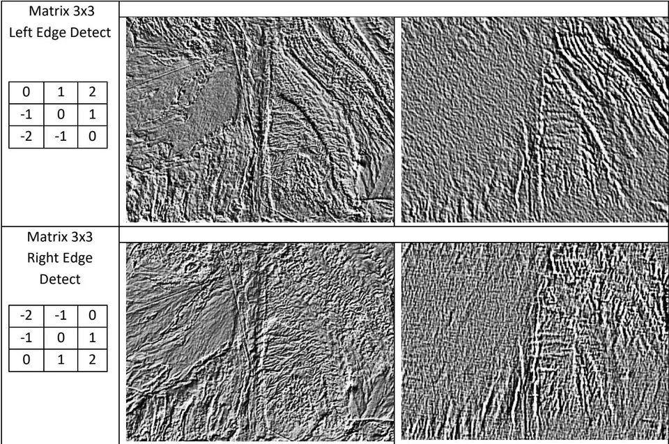
For mapping lineament tectonics and annular structures, are used filters of matrix transformations of the edge detections of the image (Fig. 2) applied to satellite image and DEM [2, 3]:
– use of shadow effects (Hillshade relief) for DEM according to radar imagery data applying the PCA algorithm;
- Convolution filters with matrices 3x3, 5x5, 7x7, etc., with edge detection in selected directions - Left Diagonal Edge Detect, Right Diagonal Edge Detect, Vertical Edge Detect, Horizontal Edge Detect [4, 5].
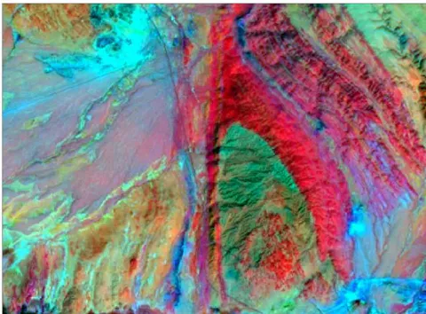
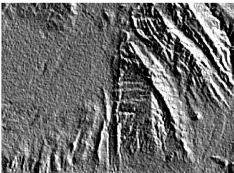
The use of Convolution filters allows to distinguish texture elements of the image, represented by gradients zones, in different directions (vertical, horizontal or diagonal), that permit to obtain data on the length and azimuthal direction of lineaments and zones of fracturing. On filtered images, lineaments identified as tectonic fractures are seen mainly as black segments crossing light zones or (less often) white segments on a black background (Fig. 2).
| Matrix type | Convolution Filter Results | |||
| For Landsat 8 image | For hillshaded DEM data in PCA processing | |||
| Matrix 3x3 Horizontal Edge Detect | 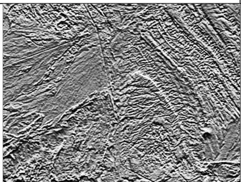 | 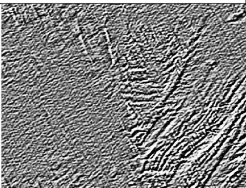 | ||
| -1 | -2 | -1 | ||
| 0 | 0 | 0 | ||
| 1 | 2 | 1 | ||
| Matrix 3x3 Vertical Edge Detect | 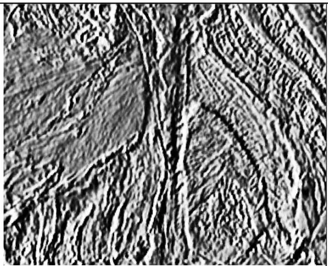 | |||
| -1 | 0 | 1 | ||
| -2 | 0 | 2 | ||
| -1 | 0 | 1 | ||
| 0 | 1 | 2 |
| -1 | 0 | 1 |
| -2 | -1 | 0 |
| -2 | -1 | 0 |
| -1 | 0 | 1 |
| 0 | 1 | 2 |
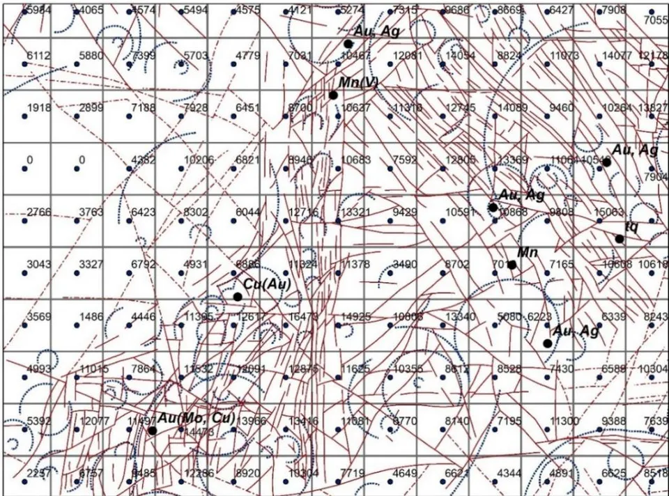
Mapping of lineaments using filtered images is carried out to create a 2D model of the Fault density field of territory, using geographic information systems, with recording in attribute table data for the identified lineaments and annular structures. For linear structures are calculated geometric parameters such as length and direction angle, which can be used to determine the general direction of the lineaments, for example, northeast, sublatitudinal or submeridional. For annular structures, length and diameter are calculated.
Ore occurrences
Value of summ lenght of Lineaments in grid cell 1000x1000 meters
Grid 1000x1000 meters
Lineaments identified from a space image with processing by convolution filters
1.Lineaments interpreted as fractures
2.Lineaments in quaternary sediments
3. Annular structures identified from a space image with processing by convolution filters
Fig. 3: Lineament's system identified from satellite images with convolution filters. Aktau intrusive, Sultanuvais mountains, Uzbekistan
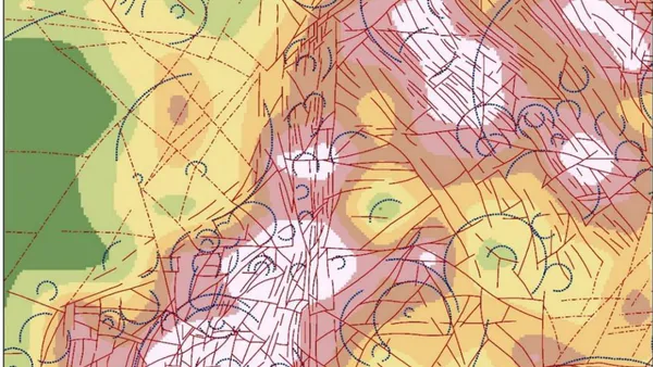
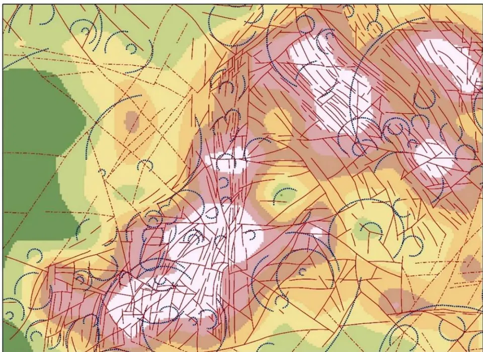
The determination of tectonic weak zones is based on a statistical analysis of the geometric parameters of lineaments per unit area, by interpolating the values of the summary length of lineament segments that located in one cell of a regular grid of 1000x1000m, using the natural neighborhood interpolation method, for a set of points of a regular network with a uniform step (Fig. 3). The raster, which is obtained by interpolation of regular points with a summary segments lengths value per unit area, displays the density field of tectonic disturbance (fault density field), or identified tectonic weak zones, and shows a qualitative assessment of tectonic fragmentation degree in territory (Fig. 4).
1.Lineaments interpreted as fractures
2.Lineaments in quaternary sediments
- Annular structures identified from a space image with processing by convolution filters Fault density field (meter per square kilometer)
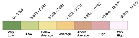
On Figure 4, "Very low" and "Low" values of the tectonic fault density field mean that there actually no tectonically weakened zones in these places. Most often, such areas have a clear spatial correlation with loose Quaternary deposits (sands, loams, etc.), which can mask the fracturing of the underlying rocks. "High" and "Very High" values of the Fault density field mapping zones of high tectonic fragmentation and, accordingly, extremely of tectonic weak zones, which serve as pathways for chemical elements migration from deep horizons to the surface [6]. The areas designated as "Below Average", "Average" and "Above Average" values of the fault density field mapping a relatively moderate of tectonic fragmentation degree, or moderately tectonic weak zones, which can be interpreted as localization zones of endogenous mineralization.
Near the Aktau intrusive, given in the article as the main example of applying the algorithm to determine tectonic weak zones, there are only 9 known
The data in the diagrams of Fig. 5 and 6 are given for the territories of the Central Uzbekistan. The statistical selection for the Nuratau Ridge consists of 919 endogenous occurrences positions distributed over an area of 28,800 square kilometers; for the Bukantau mountains is 138 positions of endogenous occurrences positions distributed over an area of 11,200 square kilometers. According to these selections, a high correlation is observed in the distribution of endogenous ore occurrences in areas with a moderate or slightly increased degree of tectonic fragmentation, that is, in medium values of tectonic weak zones.
occurrences of endogenous minerals that have a clearly expressed spatial correlation with medium and enhanced values of tectonic fragmentation (most of values correspond to from "Below average" to "High"), while only one of the occurrences corresponds to very high values, and none of occurrences belongs to very low or low values of the tectonic fragmentation. However, such a position of ore occurrences is not quite typical due to the small count of ore occurrences and the small study area (insignificant count of selection). More typical is the ratio of endogenous occurrences and the degree of tectonic fragmentation, shown in the diagrams of Figs. 5 and 6.
Use of Convolution filters for satellite images, as well as the function of hillshading for DEM with various azimuths of directions, makes it possible to identify a largest count of tectonic disturbances in the study area in the form of lineaments, compared to automatic methods or images without use of any filters. Statistical analysis of lineaments identified from filtered images makes it possible to build a map of tectonic weak zones of the crust (faults density field, or degree of tectonic fragmentation), as well as to identify systematical relationships between these zones and positions of endogenous mineralization. A large count position of endogenous mineralization on the territory of Central Uzbekistan and their comparison with the qualitative characteristics of tectonic fragmentation values admit to conclude that the concentration of endogenous mineralization belongs on medium or enhanced tectonic weak zones. This is confirmed by diagrams of ore positions and the degree of tectonic fragmentation, which in total obey the normal gaussian distribution.