
I. INTRODUCTION
Magnetic prospecting, magnetic prospecting, a geophysical exploration method based on the difference in the magnetic properties of rocks and the study of magnetic anomalies [1]. It adapts in all stages of geological studies and it includes: the measurement of the intensity of terrestrial magnetism or its elements the construction of the magnetic cards; the geological interpretation of the results of measurements, which is rested on the determinations of the magnetic characteristics of the rocks.
Magnetic reconnaissance studies magnetic anomalies, created by the geological bodies, magnetized by contemporary (induced magnetization) and ancient (remanence) by earth's magnetic field. The magnetization of rocks is determined by the presence of ferromagnetic minerals (magnetite, pyrrhotite) in them. Especially intense magnetic anomalies are created by igneous rocks of basic and ultrabasic compositions, magnetite iron ores, etc. Measurements during the magnetic reconnaissance are made on the earth's surface, from the aircraft or the helicopters (aeromagnetic survey), from the moving vessels (hydromagnetic survey or sea magnetic reconnaissance.), in mine workings (underground magnetic reconnaissance.), in the bore-holes (drilling magnetic reconnaissance). Various magnetometers are used for measurements. The relative values (increase in the space) of the vertical component of the intensity of terrestrial magnetism (ground-based DZ surveys) most frequently are measured, the module — of the vector of complete D intensity of terrestrial magnetism, T is thinner frequent than the horizontal component N and with the aeromagnetic and hydromagnetic surveys: or its increase DT. Magnetic prospecting has to take into account magnetic variations. Ground surveys, as a rule, are carried out along rectilinear profiles, with the ratio of the distances between the profiles and observation points on them from 10: 1 to 1: 1. In aeromagnetic and hydromagnetic surveys, measurements are made continuously or discretely in motion along a network of rectilinear and sometimes curvilinear (in mountainous terrain) profiles. As a result of the interpretation of magnetic survey data, the depth and other elements of the occurrence of magnetized bodies in the earth's crust are determined, which serve as sources of the anomalous magnetic field... magnetic prospecting independently, as well as in combination with other geophysical and geological methods, is used to study the regional deep structure of the earth's crust, including to determine the depth of the platform foundation (when searching for oil and gas); geological mapping of prospecting for magnetic varieties of iron ores, as well as ore and nonmetallic deposits associated with basic and ultrabasic It is clear from what has been said that the development of new devices for carrying out magnetic prospecting is an urgent task in the search for minerals and the study of the structure of the earth's surface.
- New devices for measuring the gradient of the absolute values of the magnetic field
The work A performed when moving a closed loop with a current I in a magnetic field is equal to the product of the current magnitude and the change in the magnetic flux coupled to this loop A = I . Since , where B is the magnetic field induction, and S is the area of the circuit, therefore A = I . The force acting on such a contour is F = dA/dl, where dl is the displacement of the contour. Hence F = dA/dl = I (dB/dl) S. dB/dl = F/IS. This ratio determines the magnitude of the magnetic field gradient. A magnetic needle or magnet is similar to a circuit with a current, and in order to measure the gradient of the magnetic field with it, one of the ends of the magnet should be fastened with a thread and the force acting on the thread should be measured Fig. 1.
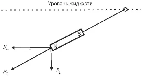
In this case, the magnet is attached with a thread to the base located on the surface of the water. In this case, the magnet turns in the direction of the magnetic field and the force acting on it is decomposed into two components, one of these components is parallel to the surface of the liquid, and the other is normal to it. These components are determined through the total force acting on the magnet and the angle between the surface of the liquid and the thread holding the magnet.
The device for measuring the horizontal components of the magnetic field gradient is shown in Fig. 2.
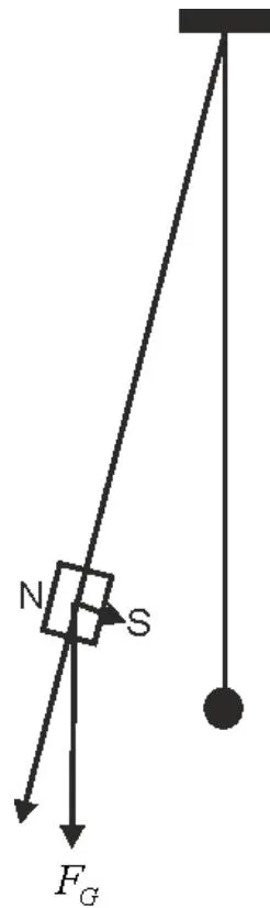
As shown in the figure, two threads are fixed to the base, at the end of one of which a non-magnetic weight is fixed, which is indicated by a black ball. The thread and the ball serve as a plumb line, in which the thread is directed vertically. On the other thread are attached cylindrical cobalt-samarium magnets. Such a magnet, located in a magnetic field, is acted upon by a magnetic force proportional to the gradient of the external magnetic field, which turns the magnet in the direction of the field. In this case, the force of gravity acting on the magnet is decomposed into two components, one of which is directed in the direction of the thread holding the magnet, and the second is normal to it. The gravitational component of the force acting on the magnet in the direction normal to the filament is balanced by the horizontal magnetic force of the external field. This force is determined through the angle between the two filaments. The specified equality is approximate, and it is the more accurate, the smaller the angle.
The considered methods for measuring the magnetic field gradient are suitable only for measuring large gradients, since the forces acting on the magnets at small gradients are small. A simple float method for measuring small horizontal magnetic field gradients is discussed below. Even the gradients of the earth's magnetic field, far from magnetic anomalies, can be measured with this method. This method is shown in Fig. 3.
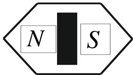
As shown in the figure, a samarium-cobalt magnet is placed on the foam float. If such a float is placed on the surface of a liquid, then, like the insole of a compass, it will turn in the direction of the magnetic field, and then begin to float towards a greater field. The speed of movement of the float will be the higher the greater the gradient of the magnetic field. By measuring the indicated speed, the gradient of the magnetic field can be measured
II. CONCLUSION
The study of magnetic anomalies in the upper layers of the earth is of great practical importance for the exploration of mineral resources. However, such studies run into a lack of simple and highly sensitive instruments for such work. New devices for measuring the gradient of the absolute values of the magnetic field