The Jurassic lithostratigraphy of the Mixtec Region is relatively well known, however the system on which is based includes formational descriptions somewhat deficient (e.g. vagueness, characterization by fossil content, insufficient cartographic discrimination). In order to contribute to correct such deficiency, we undertook a detailed study of the Río Ñumí Area, vicinity of Tlaxiaco, where the Middle Jurassic units that make up the Tecocoyunca Group display their attributes, thus allowing to supplement the formational descriptions. It was found that locally, the Tecocoyunca Group includes in the lower part the associated Formations Zorrillo/Taberna (Early to Late Bajocian), consisting of ~287m of carbonaceous siltstone, mudstone and subarkosic very fine-grained sandstone and siltstone; this composite unit bears pelecypods and continental plants, as well as two carbon zones; it is interpreted that they were part of a delta complex. These associated formations conformably underlie the Simón Formation (Middle-Late Bathonian), it consists of ~270m of subarkoses and siltstone set in thin to thick strata; it is interpreted as a transitional deposit.
## I. INTRODUCTION
The Mixteca Region (noreast of Guerrero, northeast of Oaxaca and south of Puebla states) was studied by many geologist (e.g. Wieland 1909; 1914-1916; 1926; Burckhardt, 1927; Guzman, 1950; Cortes-Obregon et al., 1957; Alencaster, 1963; Ochoterena-Fuentes, 1960; Pérez-Ibarguengoitia et al., 1965; Ojeda-Rivera, 1975; Ortega-Gutierrez, 1978; Westermann, 1983, 1984; López-Ticha, 1985; Morán-Zenteno et al., 1994; Menezes-Rocha et al., 1994; Ortiz-Martínez et al., 2013). One of the most important because of its paleontology and stratigraphy is Burckhardt (1927) which is the first and initial full- monography with descriptions and plates of fauna fossil, this work is basis of the Middle Jurassic paleontology of Mexico; Erben (1956) did the first stratigraphy of the Jurassic for the region, which includes the following lithostratigraphic units for the Tecocoyunca Group: Zorrillo, Taberna, Simon, Otatera and Yucñuti Formations. However, the system on which it is based includes somewhat deficient formalational descriptions (e.g. vagueness, characterization by fossil content and insufficient cartographic discrimination).
Moreover, the Erben (1956) stratigraphic units had been used, since then, for geologic studies; in this sense the Tecocoyunca Group (Middle Jurassic) had been identified commonly in the Mixteca. That is why, was considered convenient the study of this group of rocks at the Numí Riber area, close Tlaxiaco, which is next to Diquiyu area, Tezoatlán, Oaxaca (Fig. 1). Outcrops of this group show clearly stratigraphic and paleontologic characteristics, this information permit us to make full descriptions of the Jurassic lithostratigraphic units, and contribute for best knowledge of the regional geology. Also in this area there are Jurassic coal beams (Ramírez, 1882; Birkinbine, 1911; Cortés- Obregón at al., 1957), which give to the area economic interest.
Study area. The study area is at both sides of the Numí Riber, in the Mixteca Region, northwest of Oaxaca state, which is 10 km long and 4 km width, distributed NW-SW, almost $40~\mathrm{km}^2$ inside the followings coordinates as: $17^{\circ}16'$ - $17^{\circ}22'$ N and $97^{\circ}41'$ - $97^{\circ}46'$ W (Fig. 1) and 2000-2200m over sea level; next locality is Santiago Nundichi, which is arrived by a No.125 second class highway, also it is 5 km NE of Tlaxiaco.
## II. MATERIAL AND METHODS
Cartographic material used includes: Topographic map E14D34 Tlaxiaco, scale 1: 50 000 (INEGI, 2000); Geologic and Mines map E14D34 Tlaxiaco scale 1: 50 000 (SGM, 2000), and Geologic Map Oaxaca E14-9 scale 1: 250 000 (INEGI, 1994). Field geology methodology was applied using maps (Finkl, 1988). It was searched prior geologic information in order to know available reports and elaborate a preliminary map to be used as initial field geologic map. The geologic cartography was mapped following geologic contacts by foot and the structural stratigraphic sections also were mapped. The lithostratigraphy described have been done following the North American Stratigraphic Code (2005), spanish version (Barragan et al. 2010).
Petrographic and lithologic descriptions were done by geologic observations and field pictures, this is basically supported by 80 lithic samples and 60 thin sections; petrographic and lithologic terminology came from Folk (1974) and Boggs (2009). Fossils were collected during field geology.
## III. DISCUSSION AND RESULTS
### a) Lithostratigraphy
## i. Tecocoyunca Group
The Tecocoyunca Group name, Erben (1956) is corresponding to a sequence of sandstones, siltstone, carbonaceous shales and limestones that are outcropping in the Mixteca Region, its Type Locality is a homonymous creek, located between Cualac and Huamuxtitlan, Guerrero state ( $\sim$ 150 km west of Numí area), since then was designed as Middle Jurassic age, also at the same time was indicated that consisted of five Formations as follow: Zorrillo, Taberna, Simón, Otatera and Yucuñuti. This author also recognized the same units at Diquiyú area, Tezoatlán region, which is $\sim$ 70 km west of the study area. He pointed out that both Jurassic areas are very similar, which complement Numí River lithologic descriptions.
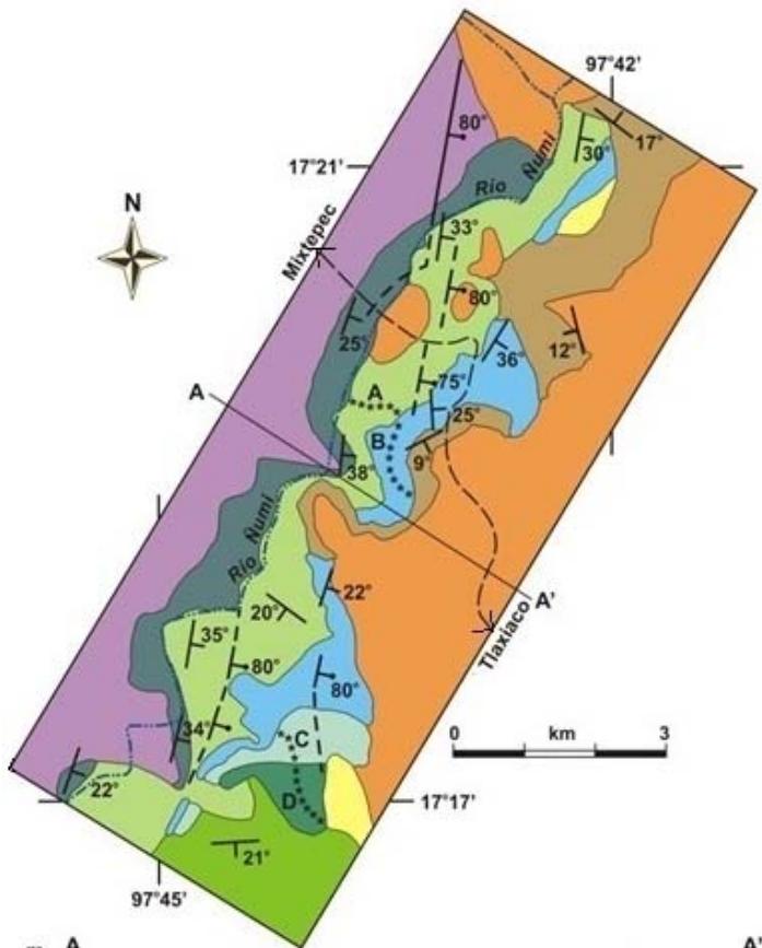
In the studied area, the Tecocoyunca Group it is outcropping both sides the Numí River (Fig. 3) and is $\sim 800\mathrm{m}$ thick; the geologic structure observed is the flank of a syncline NNE-SSW direction and $\sim 35 - 80^{\circ}$ dip, through ESE direction; also is affected by faults at 90 degrees respect to the synclinal flank (Fig. 3). Lithostratigraphy units is as follow.
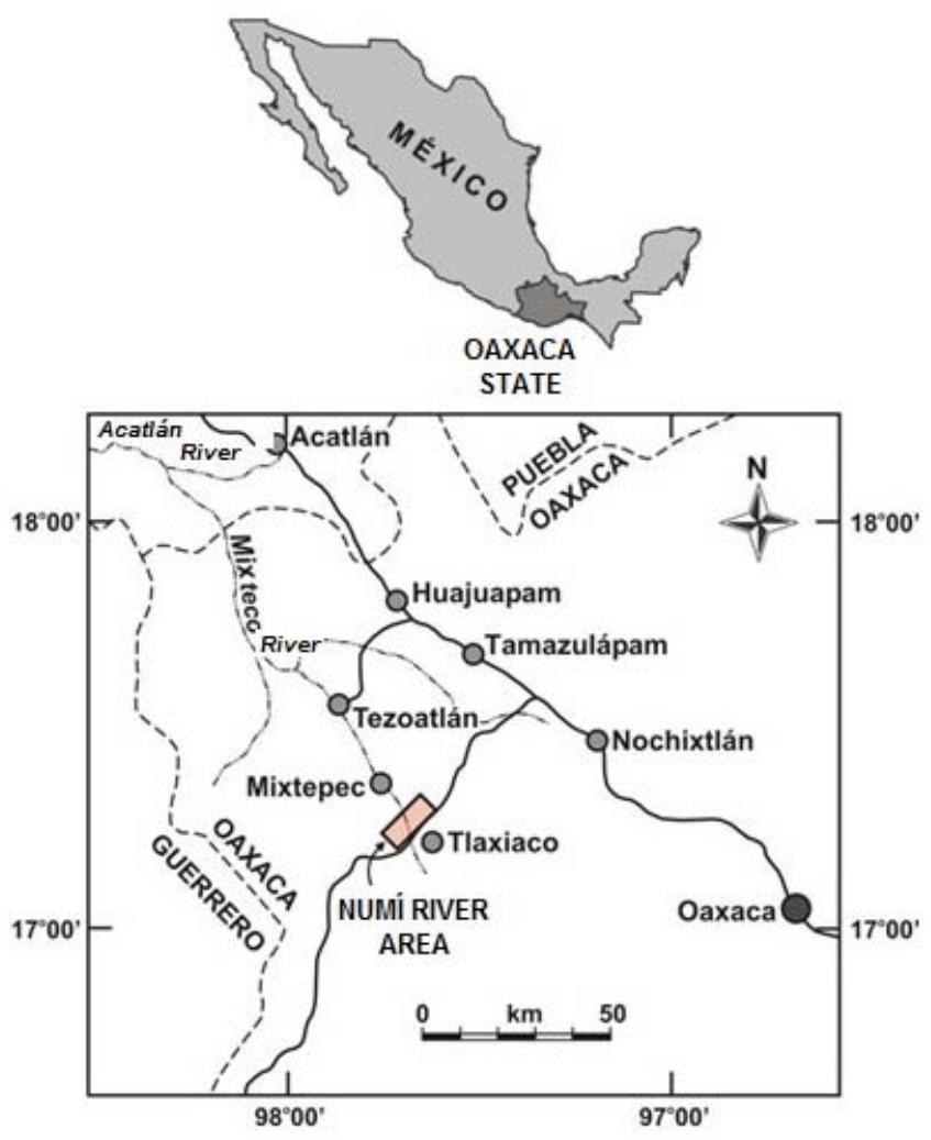 Figure 1: Localization Map of the Numí River area, close to Tlaxiaco, Oaxaca
## ii. Zorrillo/Taberna "Unit"
Erben (1956) gave the name to the Zorrillo Formation, he toke the name from the Zorrillo hill west of San Juan Diquiyú, Tezoatlán region, Oaxaca state, and also assigned Type Locality and lower Bajocian age. The Taberna Formation also was described by Erben (1956), reported the Tierra Amarilla Hill as Type Locality which is located at side south of the Taberna stream, northeast of San Juan Diquiyú, giving Middle Bajocian to Lower Bathonian age.
Lithologic descriptions of both formations are very similar and they are related transitional, this circumstance make to be difficult recognize them out the type area. This is the reason why were not possible to be recognized at Numí area. As a consequence, was decided to be considered together in one stratigraphic association called Zorrillo/Taberna "Unit", and as a result those formations were not considered individual (Figs. 2 and 3).
Outcrops of this "Unit" are very close to northwest side of Numí Riber, and are recognized with very similar lithologic and stratigraphic sequences outside in the study area.
Lower contact is transitional with Cualac Conglomerate, upper contact also is transitional with the base of Simón Formation. Total thick of this unit show variations, however an average overall from the geologic work done during this study is of $277\mathrm{m}$. The Reference Section was measure at the Yuticuani Stream (Fig. 4A).
Lithology: Main rocks of the Zorrillo/Taberna "Unit" are carbonaceous siltstone (Fgi. 5A, B, C y D) and invertebrate and plants fossils. Is clear grey and dark grey color, predominantly first. The stratifications beds are middle to thick (30 to 40 cm width); upper beds are alternatively sandstone and argillaceous siltstone.
Coal zones indicate marsh environment conditions, where tectonic and geographic conditions giving rise to peat accumulation. Two coal beams indicate cyclic of tectonic and sedimentary conditions. Were identified three follow lithology varieties:
1) Phyllite and carbonaceous siltstone (Fig. 6A). It is main variety of the Zorrillo/Taberna "Unit". Consists $60 - 70\%$ of clastic grains of the sediment, its size is from fine silt to very fine sand, predominantly middle silt; grains are sharp to sub-sharp, are well classified to middle well classified, some grains show bimodal distribution. Mostly of grains are of quartz (75%); symmetrical and elongate shape; 10%
show wave extinction which indicate metamorphic origin. The left grains show parallel or little wave extinction, it contains inclusion as bubbles. Probably alkaline feldspar is present in 5 to $10\%$ of grains mostly argillaceous altered.
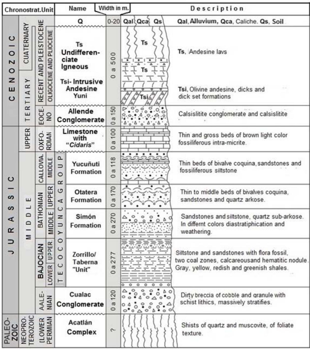 Figure 2: General stratigraphic column of the Numí River Area
Grains of mica are in 10 to $15\%$, mostly of which are reddish or bluish color biotite with 40 to $60\mu$ size. There is calcite $(\sim 1\%)$ of secondary origin. Sparing carbonaceous material consists of polymorphs and kerogeno. $30 - 40\%$ is matrix material, it consists of kaolin, chlorite,?illite and not identified ferromagnesian
(?hiperstene). With X ray diffraction equipment was identified chlorite and kaolin (done free by Mexican Geological Survey).

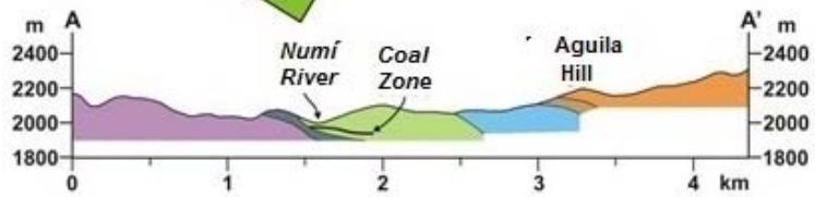
 Figure 3: Geologic map and general structural section of the Numí River area, close to Tlaxiaco
* Not continuos line indicate inferred
### Remarks
1. Geographic information was taked from'. Topographic Map 1:250,000,Oaxaca, E14-9 INGEI Edition.
2. Underground information was taked from Mexican Geological Survey (before Consejo de Recursos Minerales)
2) Quartzite - phyllite mudstone (Fig. 6B). Consist of clastic material included in an abundant argillaceous matrix (30-40%). Grains are 60-70% of the sediment, its size is from middle silt to very small sand with predominance of gross silt. Mostly of gains are sharp and unclassified. This variety mineralogy is mainly of quartz (80-90%), grains are mostly elongate and with parallel extinction, bubbles rare. Mica grains (10 to 20%) are almost completely altered, they do not have regular shape, brown reddish and brown bluish color. Matrix consists of unidentified clay and ferruginous material.
3) Quartzite - phyllite subarkose sandstone (Fig. 6C). Grains of quartz are 80 to $85\%$ of rock classified as middle sand. Mostly of grains are sub-spherical, almost well classified. Shape of grains is almost equigranular to elongate; third part of grains of wave extinction, left grains show parallel extinction. Bubbles are rare. Grains of feldspar (15 to $20\%$ ) show not-regular shape and alteration to clay.
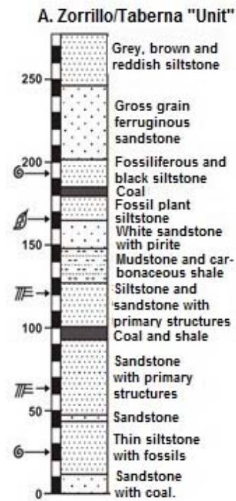
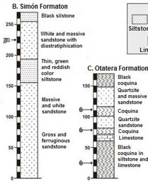
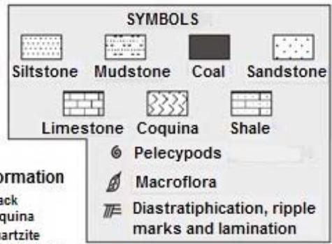
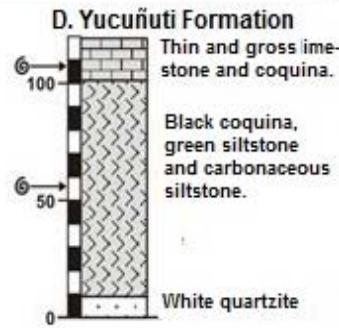 Figure 4: Main Reference Sections of the Tecocoyunca Group formations
Deposit environment. Sedimentological characteristics observed in the Zorrillo/Taberna "Unit" (e.g. spherical fragments, well to almost well classified – i.e., shoe string) suggest that this formations was deposited during fluvial channels belonged to a delta system. The environment interpretation became because of the sedimentological texture, showed by the carbonaceous siltstone which belonged to a transitional deposit with fluvial and marine influence. The abundant organic material indicate marsh conditions. The argillaceous siltstone was deposited in similar environment, also green and rose color of beds indicate some aerial expositions of the deposit. The relatively thickness unit indicate constant slow downfall of the basin, also quite tectonic conditions.
Additionally, the mineral conditions as: quartz of wave extinction, clay and mica less abundant, point out to a metamorphic source which probably was the Acatlán Complex Formation which holds granite.
At the same time findings of argillaceous feldspar fragments suggests strong weathering of sediments before were deposited; this was happening easily with humid and hot weather climate of the source area. From middle to long distance of transport are suggested by taking account texture and silty argillaceous sediments.
As a summary the observed features give the conclusion that the Zorrillo/Taberna "Unit" represent two deposit environments: Main one was coastal marsh and the other less sized fluvial; at the same time both were part of a deltaic system (see Reineck and Singh, 1980; Howard and Reineck, 1981; Reading, 1996).
Moreover, the two coal seams that were founded in this "Unit" indicate that happening following conditions (Stach, 1975; Tatsch, 1980): a) Constant and slowly slowdown, b) Marsh protected by beach and sand dikes, also natural dykes against marine inundations and river inundations, c) An slow energy environment of the continent and slowly sediment deposit, otherwise were not be possible peat deposits.
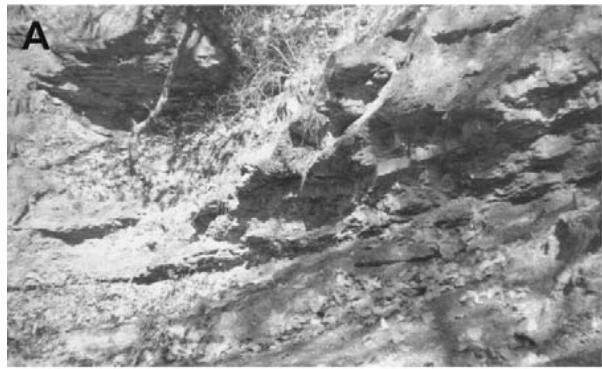
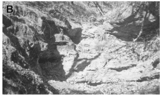
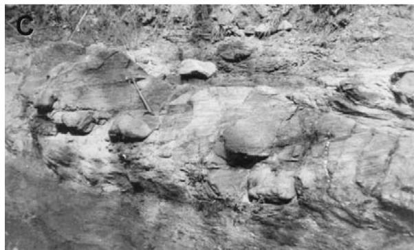
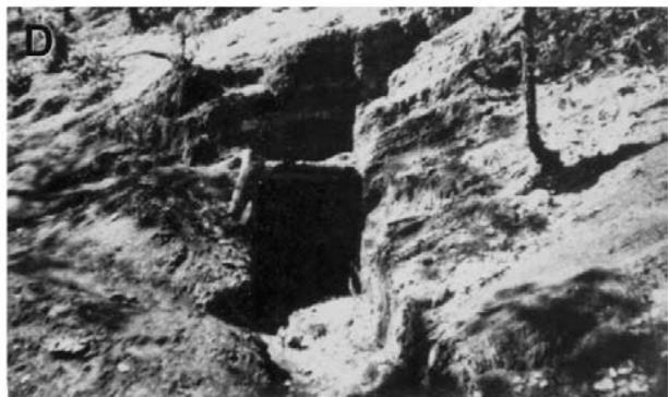
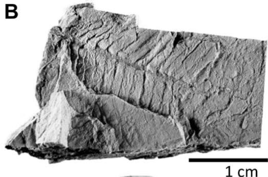
Figure 5: Outcrops of the Zorrillo/Taberna "Unit": A) La Carbonera Stream, show fine grained siltstone and sandstone, road to San Juan Mixtec, Km 6. B) Chicavandicuche Stream, show fine grain siltstone and sandstone, Idem km 6 C) Bridge on the Mixtepec road, show siltstone, Idem, km 8. D) Small Tunnel, show carbonaceous siltstone and lamination of coal, Idem, km 8.5
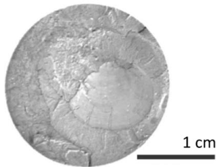
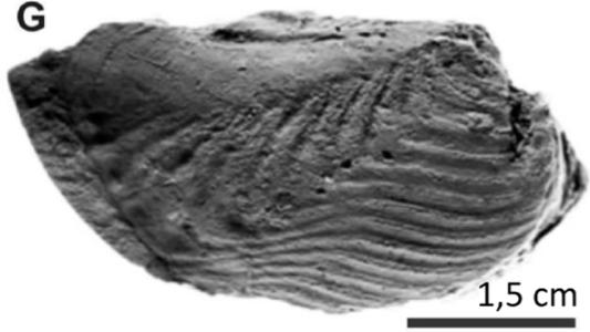
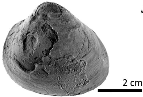
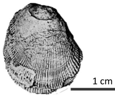
Fossil collected. Mollusks fauna collected was pelecypods (see Fig. 13E-H) such as: Lucina cf. L.bellona, Astarte sp, Vaugonia (Vaugonia) v. costata var. Mexicana, Trigonia (Indotrigonia) impressa (Alencaster, 1963; Alencaster and Buitrón, 1965) which were of cosmopolitan distribution from marine or brackish environment. The continental macro flora collected are taxa such as: Zamites oaxacensis, Zamites lucerensis, Williamsonia netzahualcoyotli, Ptillophyllum acuiforme (see Fig.13A-D) well known from the Mixteca Region, they belonged to humid and hot weather environment of continental flora (Wieland, 1914-1916; Silva - Pineda,1970;Silva-Pineda et al, 1986a,b; Pearson, 1976; Ortiz-Martínez et al., 2013).
Age. The fossils taxa stratigraphic lapse collected in the Río Numí area is as follow: The bivalve are from Bajocian to Callovian age. Stratigraphic lapse of flora fossil founded is longest (Pearson, 1976; Sandoval and Westermann, 1986; Carrasco-Ramírez, 1999).
However taking in consideration that Mixtepec and Río Numí areas are next, also because the Taberna Formation hold ammonites of Early to Late Bajocian age, is deigned this age to the Zorrillo/Taberna "Unit".
## iii. Simón Formation
Erben (1956) described this unit, and assigned to the Middle Bathonian age, selected as Type Locality the Stream of Simón at the Carrizo cliff, noreast of San Juan Diquiyú, in the Tezoatlán region, Oaxaca.
At the study area, Simón Formation is outcropping mainly in the Allende Stream where was measured the Reference Section (Fig. 4B). The lower contact is transitional with Zorrillo/Taberna "Unit", upper contact is not transitional but concordant with the Otatera Formation. The Simón Formation thickness is $\sim 270\mathrm{m}$.
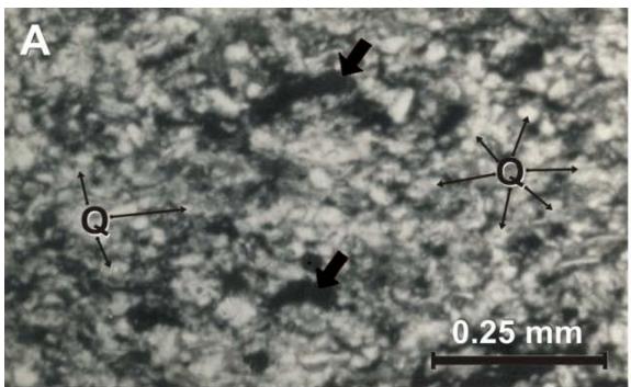
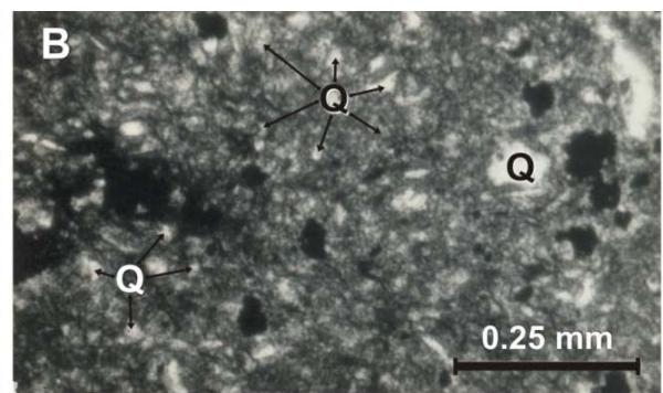
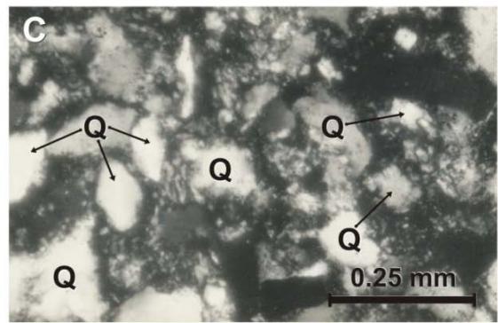
Figure 6: Micro-photographs of the Zorrillo/Taberna "Unit": A) Carbonaceous- phyletic siltstone, at natural light conditions. Clay cement, grains are mainly of quartz (Q) and carbonaceous material is in small forms, pointed out by arrows. B) Quartzite-phylitic mudstone observed by crossed nicol. It is observed mainly clay and clastic grains of quartz and mica (M). C) Subarkosic quartzite phyletic mid-grain sandstone observed by cross nicol. Quartz grains are plentiful
Litology: Main part of the Simón Formation is a middle to gross grain subarkose sandstone, grey to white color, with beds of 0.40 to $1\mathrm{m}$ and to $1.5\mathrm{m}$ when grain size increase, this beds belonged to a group of beds mainly of reddish or bluish siltstone, which thickness is from 10 to $50\mathrm{m}$. There are some red ferruginous nodules. There is mainly diastratification as primary structure (Figs 7A-7B). Description of the common lithology identified is as follow:
1) Middle grain quartzite-subarkose sandstone. This lithologic variety is main part of this formation (Fig. 8A). $95\%$ are made of grains which $\sim 80\%$ are of quartz, from this $25\%$ show wave and composed extinction, which suggest metamorphic provenience, left of grains show parallel extinction. Irregular grains of? Alcaline feldspar (15 to $20\%$ ) show fractures well done. Weathering not permit good identification. Were found trace of mica mainly biotite and of heavy minerals as garnet and turmaline; last are suggesting schists and pegmatite rocks provenience (see Folk, 1974). Matrix is $5\%$ of rock which is of middle silt made of argillaceous mica and clay; secondary minerals are hematite and calcite, this last is cement and is filling porous places.
2) Phyllitic siltstone. Clay or fine silt texture, it is made of grains of quartz with wave extinction, argillaceous
mica and ferromagnesian alteration; its matrix is argillaceous (Fig. 8B).
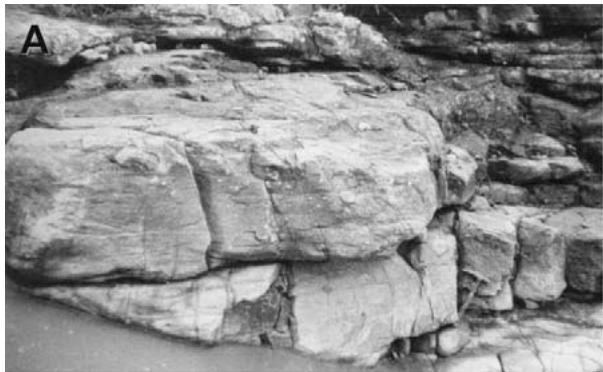
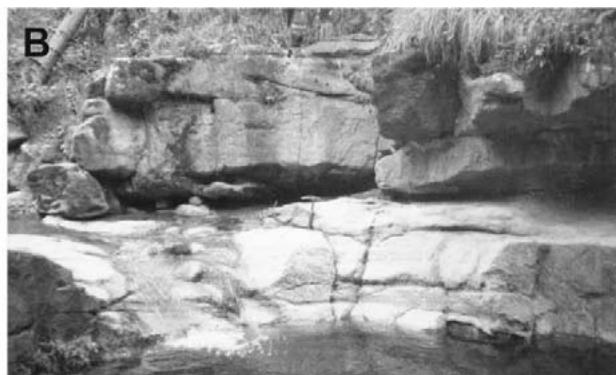 Figure 7: Outcrops of the Simón Formation, are observed conglomeratic sandstone with diastratiphication structures: A) Allende stream, Allende road, km 11 B) Yuni stream, San Juan Mixtepec road, km 6
Deposit environment. Wave extinction of quartz, suggest that provenience area was metamorphic rocks, probably the Acatlan Complex. Grains of quartz of parallel extinction indicate that provenience area was formed by igneous rocks (?granite). Besides, size of grains (fine silt) indicate middle length to too long transport; also diastratification indicate fluvial environment (inundations plains and front of delta facies); at the same time reddish colorations indicate this deposits were exposed to aired oxidation (see Reineck and Sing, 1980; Reading, 1996). As a summary we can said that Simón Formation had a sedimentation development similar to Zorrillo/Taberna "Unit"; Simón Formation sedimentation was fluvial but mainly beach environment.
Age. There is not paleontologic or radiometric information that support age of this unit, at this circumstance the stratigraphic relationship is useful. The
Simón Formation transitionally overlay the Zorrillo/Taberna "Unit" which is of Bajocian age and its upper contact is concordant with Otatera Formation of Late Bathonian age (Fig. 9). So, Simón Formation is probably Late to Middle Bathonian age.
## iv. Otatera Formation
Erben (1956) gave the name to this sedimentary rocks which have their Type Locality at central and southcentral of the Otatera creek, Rosario River in the Tezoatlán region, Oaxaca, giving Late Bathonian age. Its distribution is small area in the Doña Chona Stream, south of the study area (Fig. 3), it consists of $\sim 170\mathrm{m}$ width of sandstones and coquina (Figs 2 and 9) and is interlayered with basal beds of the Simón Formation, upper part is over layered by the Yucñuti Formation. Reference Section was measure at Doña Chona Stream (Fig. 4C).
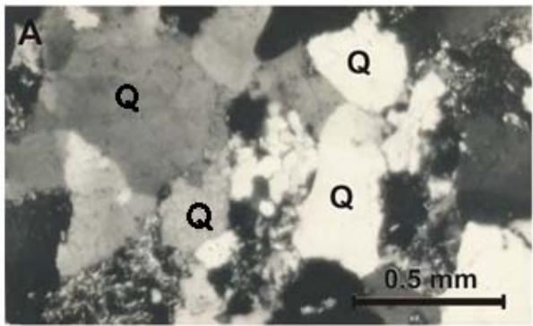
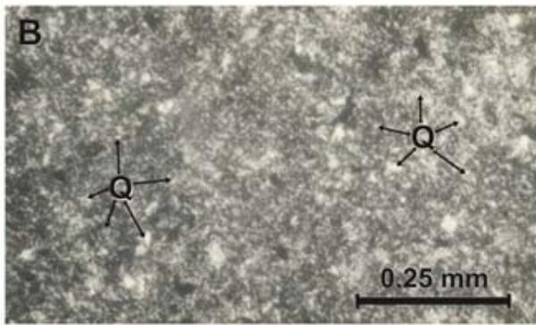
Figure 8: Micro photographs of Simón Formation: A) Quartzite subarkose middle grain sandstone observed with crossed nicole. There are igneous quartz composed (grey) and igneous included in silt. B) Phyletic siltstone parallel light observed. Microcrystals of clay and fine silty size are plentiful with poor quartz
Lithology: Mostly of Otatera Formation is constituted by beds of black coquina of following genus of bivalves: Eocallista, Pleuronya, Crenotrapezium and ostracoda (Gryphaea), with sparite cement (Fig. 9). Coquina beds are mainly interlayered with calcareous beds of brown grey color, which consists of small fragments of calcspar and black color shells. Whole group of coquina are interlayered by thin beds of limestones from 4 to 5 cm width. Upper part is constituted of thin beds (1 to 20 cm width) of fine and gross grains of sandstones.
The Otatera Formation include few lithic variation, most common is sparite (Fig. 10). This is sub mature calcarenite, it contains few lithic fragments (gross sands size), constituted by tuffs $(\sim 3\%)$, subarkose $(3\%)$, quartz $(2\%)$ and probably alkaline feldspar $(2\%)$. Grains are cemented by sparite calcspar $(\sim 90\%)$, which crystals are 5 to $10\mathrm{m}\mu$.
Deposit environment. Sedimentary features of this unit indicate a shallow marine environment (neritic) with short terrigenous deposit, where water movement was able to erode unconsolidated microcrystalline calcite and re-deposit it as sparite. Relative close terrigenous material, indicate topographic high. It is important to know that upper middle of this unit are thin beds that consists of sandstones (fine to gross grains) become thick as increase grain size. This deposit characteristics suggest probably beach environment.
Moreover, coquina beds indicate continuous buried, which not permit groups of bivalve subaerial destruction; only relatively fast sinking of the basin could be the reason.
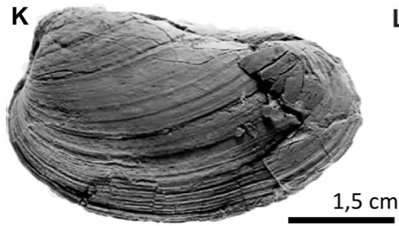
Fossil collected. Were collected mainly bivalves of the genus Eocallista, Pleuromya, Crenotrapezium (Fig. 14 I-L) (Alencaster, 1963; Alencaster and Buitrón, 1965) which were living in tide zone environment (Reineck and Singh, 1980); consolidated remains of this mollusks made coquina.
Age. Stratigraphic extension of taxa collected is large and is not possible to be assigned Jurassic age to this formation. However, in Tezoatlán area, the Otatera Formation hold ammonites among which is Epistrenoceras paracontrarium from Late Bathonian age (Erben, 1956), this make possible to be assigned same age to this unit.
## v. Yucunuti Formation
Erben (1956) designed as Yucñuti Formation a sedimentary sequence outcropping at the (homonymous) Yucñuti Stream (chose as Type Locality), located east of Santa Maria Yucñuti, Tezoatlán region, Oaxaca, and assigned Callovian age.
In the Numí River area this formation is located at south position, particularly where the Doña Chona Stream is. Its covering is short (Fig. 3). Lower beds interlayered with Otatera Formation and upper beds are discordantly overlay by Limestone with "Cidaris"; it is $\sim 118$ m width (Fig. 2). Reference Section was measured in the mentioned stream (Fig. 4D).
Lithology. The Yucuni Formation is a sequence that starting with fine grains of whitish and rose colors sandstones (Fig. 11); middle part consists of black color ostracods coquina interlayered by light grey siltstone with several burrows. Upper parts consist of middle thick beds (20 to $30~\mathrm{cm}$ ) of fossiliferous limestones interlayered by thin beds of Lucina coquina. Restricted beds of coquina alternate with ostracoda and pelecypod species. Main identified lithology are described as follow:
1) Quartzite siltstone. Is gross siltstone, middle classified, with sub mature texture (Fig. 12A). Grains are $\sim 70\%$ of rock volume, its constitution is of quartz with parallel $(\sim 80\%)$ or wavy $(20\%)$ extinction; grains size are $\sim 30\mu m$. Besides there is argillaceous matrix $(30\%$ of rock); sparite is cement and fill micro structures and hollows.
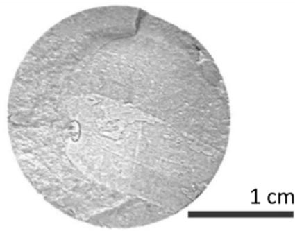
 Figure 9: Outcrop show Simón Formation with Otatera Formation contact. It is observed black coquina resting on sandstone
2) Quartzite - subarkose siltstone. Rock constitution is $70 - 80\%$ of grains with argillaceous matrix short abundant (20-30% of rock), which give a sub mature texture (Fig. 12B). Grains are constitute by quartz $(70 - 80\%)$, sharp grains with parallel extinction (wavy extinction are rare), size typically is bimodal $(10\mu m$ and $40~\mu m)$. Left grains (20 to $30\%$ ) are constitute by feldspar (?alcaline), crystals are fractured and change, its average size is $40~\mu m$. Matrix consists of clay, mica and calcite micro-crystals. Plutonic origin suggested by quartz type.
3) Biomicrite with silt quartzite. This characteristic variety, consists of bio clasts (30%) and micrite (40%) (Fig. 12C). Bio clasts typically are fragments of bivalves. Terrigenous clasts are $\sim 20 \mu \mathrm{m}$ size, they include parallel and wavy extinction quartz as well as lithic clasts (?ignimbrite).
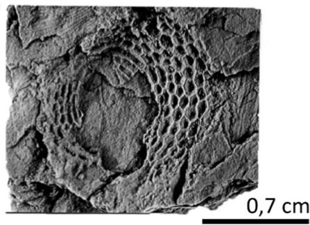
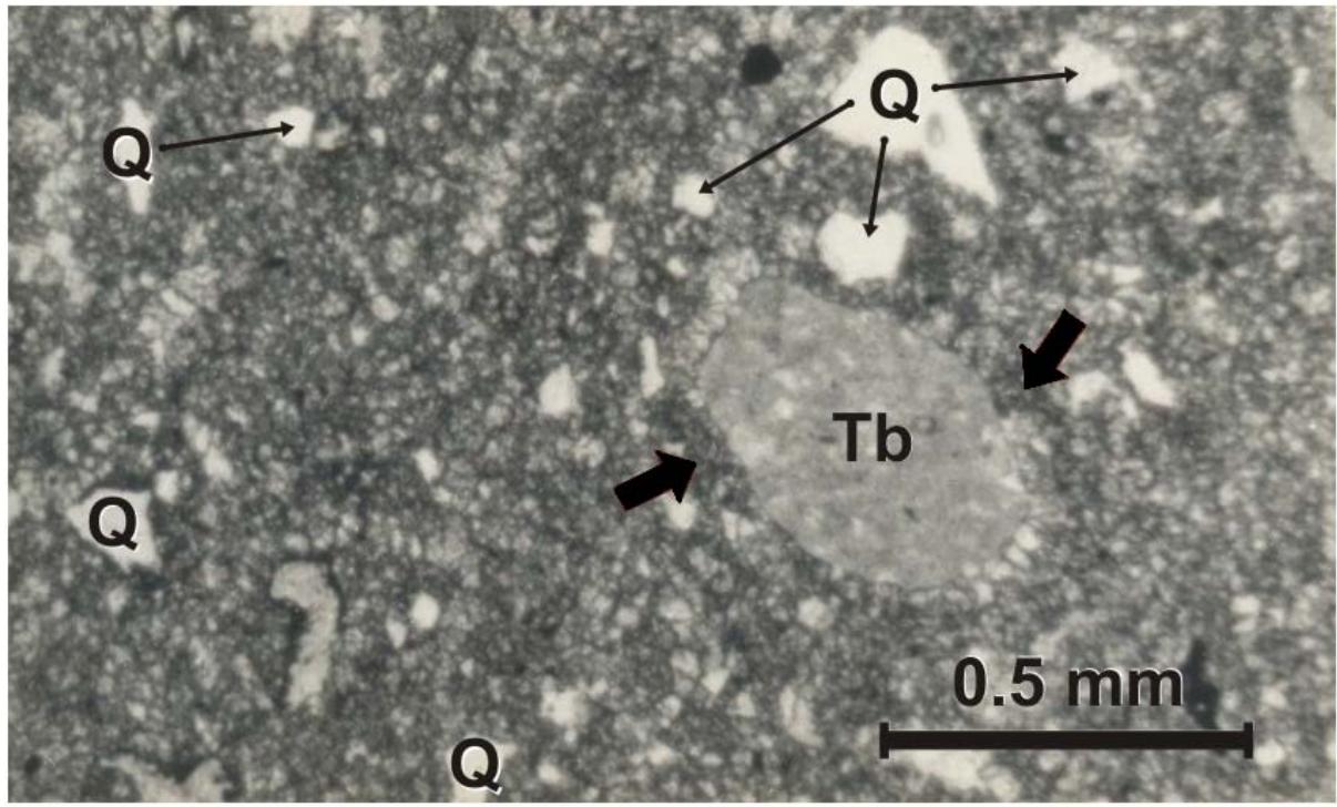 Figure 10: Otatera Formation: Micro photograph using parallel light. There is big tuff grain (Tb) surrounded by spathite (arrows point out)
Deposit environment. Lithic variety suggest a shallow marine/transitionally deposit environment, 1) and 3) varieties are of neritic environment, meanwhile variety 2) indicate terrigenous supply at plain stagnation water basin. Mineral composition and texture of described lithic varieties suggest that supply area, could consists mainly of igneous (?granite) and metamorphic bodies, which were located relatively far from the sedimentary basin.
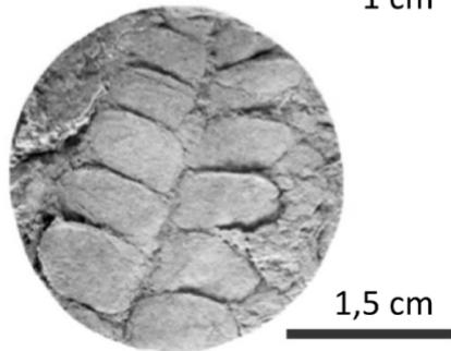
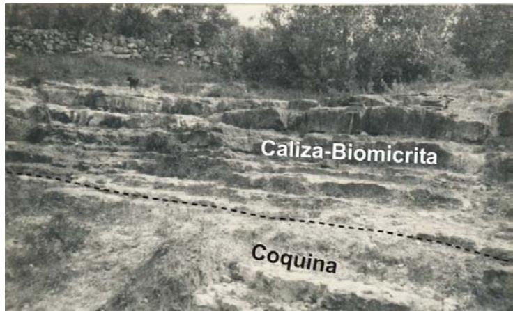 Figure 11: Outcrop of Yucunuti Formation. Thin beds of light grey biomicrita and coquina
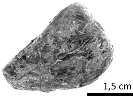
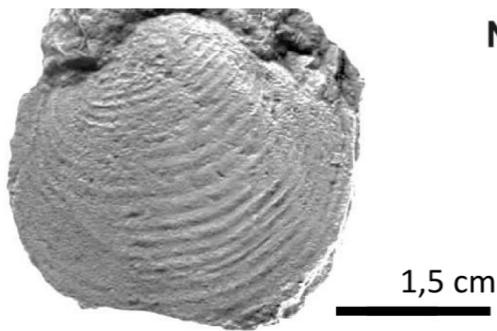
Fossils collected. In the Yucñuti Formation were collected cosmopolite mollusks such as genus: Lucina, Astarte, Vaugonia, Gryphaea, Eocallista, Crenotrapezium, Pleuromya, and Lima, (Fig. 14 M - N) (Alencaster, 1963; Alencaster and Buitrón, 1965) which belonged to a marine or saline environment.
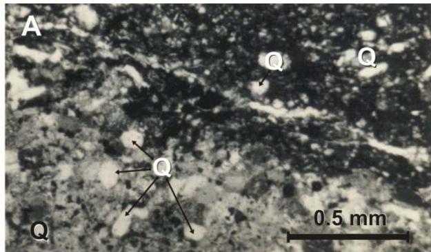
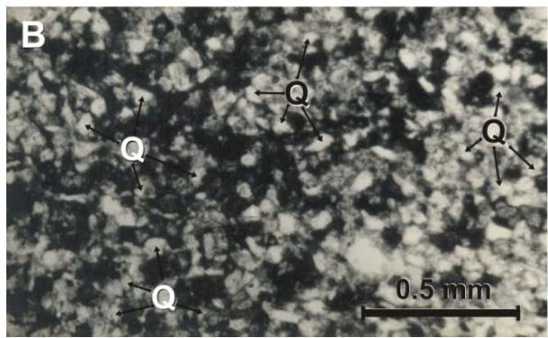
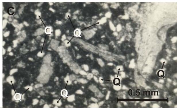 Figure 12: Micro photograph of the Yucñuti Formation. A) Gross grains of quartz sand siltstone using parallel light. Have a look that grains of quartz are abundant. C) Biomicrite and quartzite
Age. The stratigraphic length of mollusks do not give age to this formation. However in the Mixtepec area Carrasco-Ramírez (2003) collect Middle Callovian ammonites; moreover in Mixtepec and Numí River areas outcrop same stratigraphic sequences, this circumstance give age to the Yucuñuti Formation.
A
B
 C D
 E F
 G H
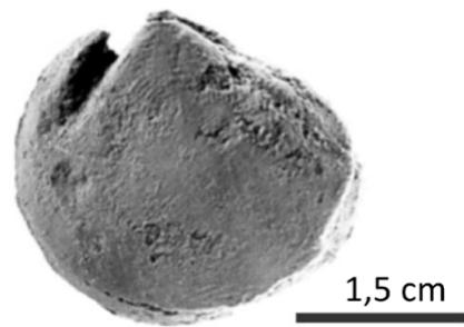
Figure 13: Specimens collected from the Zorrillo/Taberna "Unit". A) Zamites oaxacencis B) Zamites lucerensis, C) Williamsonia netzahualcoyotli, D) Ptilophyllum acutifolium, E) Lucina cf. L. bellona, F) Astarte sp., G) Vaugonia (Vaugonia) v-costata var. mexicana, H) Trigonia (Indotrigonia) impressa
## IV. CONCLUSIONS
Tecocoyunca Group in the Numí River area, Tlaxiaco region, Oaxaca, consists at its lower part of the Zorrillo/Taberna "Unit" of Lower (late part) Bajocian and Late Bajocian (begin part) age, transitional is overlaying Cualac Conglomerate of Aalenian age, they are $\sim 287$ m thick constituted by carbonaceous siltstone, mudstone, subarkose, very fine grained sandstone and siltstone, hold bivalves and fossil flora, as well as two coal beams, one at the lower part and the other at middle of upper part. The inferred deposit environment of this unit is a delta complex, composed by coastal marsh and fluvial contributions. This units are overlaying by Simón Formation, of Middle-Late Bathonian age, which is constituted by $\sim 270\mathrm{m}$ of thin and gross beds of siltstone and subarkose set; its deposit environment inferred is transitional (beach zone). The Simón Formation is transitionally overlay by Otatera Formation of Late Bathonian age, which consists of pelecypods coquina with interlayers of spathite limestone strata of $\sim 170\mathrm{m}$ thick; the inferred deposit environment of this unit is shallow marine, and some contribution of beach. This unit is concordantly overlay by Yucuñuti Formation of Middle Callovian age, which is constituted by fine grain sandstone, coquina and biomicrita $\sim 118$ m thick, holding bivalves; the inferred deposit environment is transitional (flood plain, coastal marsh and shallow neritic zone); this unit is discordant overlay by Limestone with "Cidais" of Oxfordian age.
Taking in consideration detailed descriptions of the Tecocoyunca Group formations, is de facto redefinition advance work for the Middle Jurassic units of the Mixteca Region (see NACSN, 2005, Art. 18, Remark b).
1 J

 K L
 M N
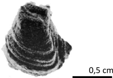
N Figure 14: Specimens collected from the Oatera Formation. I) y J) Eocallista imlayi, K) Pleuromya sp., L) Crenotrapezium hayam. Specimens collected from the Yucunut Formationi. M) Lucina sp., N) Lima (Plagiotoma) sp., N) Gryphaea mexicana
### ACKNOWLEDGMENTS
I thank economic support of CONACyT during my degree studies. Thanks to Dr. Ismael Ferrusquía and colleagues from Instituto de Geología, UNAM, for their manuscript revision. Also Drs. Gilloria Alecaster and
Blanca Buitrón help me identify mollusks collected. Dra. Alicia Silva studied and identified fossil flora for this research work. Other persons support and help me without any interest, to them all, I deeply thankful.
Generating HTML Viewer...
References
44 Cites in Article
G Alencáster (1963). Pelecípodos del Jurásico del noreste de Oaxaca y noroeste de Guerrero: Universidad Nacional Autónoma de México, Instituto de Geología.
Gloria Alencáster De Cserna,Blanca Buitrón (1965). Parte II. Fauna del Jurásico Superior de la región de Petlalcingo, Estado de Puebla.
R Barragán,E Campos-Madrigal,I Ferrusquía-Villafranca,I López-Palomino,Gustavo Tolson (2010). Código Estratigráfico Norteamericano.
S Boggs (2009). Petrology of Sedimentary Rocks.
C Burckhardt (1927). Cefalopodos del Jurásico Medio de Oaxaca y Guerrero.
Birkinbine (1911). Exploration of certain iron ore and coal deposits in the state of Oaxaca.
. Carrasco-Ramírez (1999). Los Ammonites del Caloviano de la región Mixteca, Oaxaca, México.
Raúl Carrasco-Ramírez (2003). Los Ammonites del Caloviano de la región Mixteca, Oaxaca, México.
Jesús Linares-Flores,Fernando Navarro Martínez,Arturo Hernández Méndez,José Juárez-Abad,Juan Montesinos-García (1957). Decentralized passivity-based control for cooperative power modules in the DC Microgrid System.
H Erben (1956). El Jurásico Medio y el Calloviano de México.
F Unknown Title.
J Felix (1891). Versteinerungen aus der Mexicanischen Jura und Kreide Formation.
T Crimes (1988). Encyclopaedia of Field and General Geology by Charles W. Finkl, Jnr, Van Nostrand Reinhold Inc., 1988, distributed through Chapman and Hall, London. No. of pages: 911. Price: £68.95 (hard–back).
R Folk (1974). Petrology of sedimentaryy rocks.
E Guzmán (1950). Geología del noreste de Guerrero.
J Howard,H Reineck (1981). Depositional facies of high-energy beach to offshore sequence: Comparison with low-energy sequence.
D López-Ticha (1985). II Convención de la Asociación Mexicana de Geólogos Petroleros.
J Meneses-Rocha,M Monroy-Audelo,J Gómez-Chavarría (1994). II Convención de la Asociación Mexicana de Geólogos Petroleros.
D Morán-Zenteno,M Caballero,R Silva,G Ortega,T González (1993). Jurassic-Cretaceous paleogeographic evolution of the northern Mixteca terrane.
Nacsn) (2005). NORTH AMERICAN STRATIGRAPHIC CODE.
J Ojeda-Rivera (1975). Revaluación geoeconómica de los depósitos de carbón del área de Tezoatlán.
H Ochotorena-Fuentes (1963). Amonitas del Jurásico Medio y del Calloviano de México, 1.
H Ochotorena-Fuentes (1966). Unknown Title.
Fernando Ortega-Gutiérrez (1978). Notas sobre la geología del área entre Santa Cruz y Ayuquila, Estados de Puebla y Oaxaca.
E Ortiz-Martínez,M Velazco De León,I Salgado-Ugarte,A Silva-Pineda (2013). Clasificación del área foliar de las gimnospermas fósiles de la zona norte de Oaxaca, México.
J Pérez-Ibargüengoitia,Alfonso Hokuto-Castillo,Zoltan De Cserna (1965). Parte I. Reconocimiento geológico del área de Petlalcingo-Santa Cruz, Municipio de Acatlán, estado de Puebla.
C Pearson (1976). The Middle Jurassic flora of Oaxaca.
S Ramírez (1882). EL DISTRITO DEL CENTRO DEL ESTADO.
H Reading (1996). Sedimentary Environments: Processes, Facies and Stratigraphy, 3rd Edition.
H Reineck,E Singh,I:B (1980). Depositional Sedimentary Environments.
J Sandoval,G Westerman (1986). The Bajocian (Jurassic) ammonite fauna of Oaxaca, Mexico.
Sgm (servicio Geológico Mexicano (2000). Mapa Geológico de Colombia y Atlas Geológico de colombia 2015. Escala 1:1.000.000. Producto.
Alicia Silva-Pineda (1970). Plantas del Jurásico Medio del sur de Puebla y noroeste de Oaxaca.
A Silva-Pineda,B Buitrón,R Carrasco (1986). Bioestratigrafía del Jurásico de la región de Tlaxiaco, Oaxaca.
Bárbara Cariglino (1986). El Pérmico de la Cuenca La Golondrina: paleobotánica, bioestratigrafía y consideraciones paleoecológicas.
E Stach (1975). Coal Petrology: Gebrüder Borntraeger.
G Westermann (1983). The Upper Bajocian and Lower Bathonian (Jurassic) ammonite Faunas of Oaxaca, Mexico and west Thetyan affinities: Universidad Nacional Autónoma de México, Instituto de Geología.
G Westermann (1984). The Late Bajocian Duashnoceras association (Jurassic Ammonitina) of Mixtepec in Oaxaca, México, en Congreso Latinoamericano de Paleontología.
G Wieland (1909). The Williamsonias of the Mixteca Alta.
G Wieland (1914). La flora liásica de la Mixteca Alta.
No ethics committee approval was required for this article type.
Data Availability
Not applicable for this article.
How to Cite This Article
Raúl Sabino Carrasco-Ramírez. 2026. \u201cMiddle Jurassic Lithostratigraphy of the Tecocoyunca Group in the Numí Riber Area (Close To Tlaxiaco), Oaxaca\u201d. Global Journal of Science Frontier Research - C: Biological Science GJSFR-C Volume 23 (GJSFR Volume 23 Issue C1): .
Explore published articles in an immersive Augmented Reality environment. Our platform converts research papers into interactive 3D books, allowing readers to view and interact with content using AR and VR compatible devices.
Your published article is automatically converted into a realistic 3D book. Flip through pages and read research papers in a more engaging and interactive format.
The Jurassic lithostratigraphy of the Mixtec Region is relatively well known, however the system on which is based includes formational descriptions somewhat deficient (e.g. vagueness, characterization by fossil content, insufficient cartographic discrimination). In order to contribute to correct such deficiency, we undertook a detailed study of the Río Ñumí Area, vicinity of Tlaxiaco, where the Middle Jurassic units that make up the Tecocoyunca Group display their attributes, thus allowing to supplement the formational descriptions. It was found that locally, the Tecocoyunca Group includes in the lower part the associated Formations Zorrillo/Taberna (Early to Late Bajocian), consisting of ~287m of carbonaceous siltstone, mudstone and subarkosic very fine-grained sandstone and siltstone; this composite unit bears pelecypods and continental plants, as well as two carbon zones; it is interpreted that they were part of a delta complex. These associated formations conformably underlie the Simón Formation (Middle-Late Bathonian), it consists of ~270m of subarkoses and siltstone set in thin to thick strata; it is interpreted as a transitional deposit.
Our website is actively being updated, and changes may occur frequently. Please clear your browser cache if needed. For feedback or error reporting, please email [email protected]
Thank you for connecting with us. We will respond to you shortly.