




1. Introduction: Northern Supergrid Much Needed in the Sub-Arctic and Arctic
1.1 Transformative Strategy
The future of Canada's economy, well defined by intra-regional, inter-regional, and international trade, anticipates economic development growth of the near-Northern, Northern, and Arctic regions.
Realization of the Arctic Economic and Security Corridor transformative strategy for Canada's North enabling its "full economic potential" [1, 2] through the development of trade corridors, clean energy, and critical minerals requires "new, generational investments and initiatives to defend, connect, and transform" Canada's North and the Arctic.
The necessity of bi-directional trade corridors of national scale was highlighted by the Senate of Canada in 2016–2017 [3, 4, 5, 6].
The most recent measures to defend, build, and transform the North, backed by generational investments, were announced by the Federal Government on March 12, 2026 [1, 2].
1.2 Multimodal Right-of-Way
To address the lack of widespread northern corridor and infrastructure development, in 2016 a Canadian Northern Corridor (CNC) concept was proposed [7, 8]. The concept presented a connected series of pathways linking Canada's northern communities and development projects to the three coasts: Atlantic, Pacific, and Arctic, and to the southern trade and transportation corridor. The CNC concept also envisioned accompanying policy, regulatory, and governance structures.
According to the concept, the Northern Corridor would establish a new multimodal (road, rail, pipeline, electrical transmission, and communication) right-of-way through Canada's north and near north. "Northern Corridor would prepare the way for privately funded and economically driven projects to, for example, transport a full range of export commodities efficiently to port facilities on all three coasts while also improving economic development and living conditions in remote areas. This infrastructure would improve access for Canadian goods to alternative markets, assist with trade diversification, enhance regional development and interregional trade opportunities in Canada, support northern and Indigenous economic and social development goals along with Arctic sovereignty objectives, mitigate environmental risks through monitoring and surveillance within a contained footprint and reduce the emissions intensity of transportation in Canada's north and near-north" [9].
The Northern Corridor concept was seen as "practical and focused response to the need for government to do what government should do in terms of infrastructure—create the environment in which private investment, properly regulated, can be applied to projects without intransigent 'one-off' regulatory processes for a new right of way for each project. The establishment of a multimodal right-of-way facilitates a long-term, integrated approach to the approval, construction and operation of infrastructure. Another benefit of the Northern Corridor concept is that comprehensive approaches, which due to their scale allow for accommodation of many diverse interests, can (paradoxically) be more achievable than a series of incremental steps."
To define and address the CNC concept issues, an interdisciplinary research effort—the Canadian Northern Corridor Research Program—was led by the University of Calgary and the Centre Interuniversitaire de Recherche en Analyse des Organisations (CIRANO) in Montreal. The CNC Research Program was launched in 2015 and officially completed in March 2023. It presented "an investigation of the feasibility, desirability and acceptability of the corridor concept in advancing integrated, long-term infrastructure planning and development in Canada" [10, 11]. This involved "a series of multi-modal rights-of-way across mid- and northern Canada to provide space for efficient, timely and integrated development of infrastructure, including combinations of road, rail, transmission, pipeline, communications, port and airport infrastructure" [12, 13, 14]. The notional corridor proposed reaches across Canada's mid- and northern regions, connecting all three ocean coasts and creating interlinkages with the existing southern trade corridors [15].
Selected results of the two-phase CNC Research Program are presented in [11, 12, 13, 14, 15].
A set of broad recommendations promoted a well-segmented approach to the national mega-scale Northern Corridor contributing to a holistic Economic and Security strategy. The recommendations included the following [15]:
- Canada needs a long-term strategic and integrated infrastructure vision for mid- and northern Canada that focuses on communities' long-term policy priorities.
- Streamlining of regulatory frameworks is required to improve efficiency, integration, and co-ordination in the planning and approval of hard and soft infrastructure development.
- Infrastructure policy development for mid- and northern Canada must focus on collaborative approaches that foster co-operation and co-ordination.
- Recent challenges experienced with global and Canadian supply chains underline the need for strategic and targeted infrastructure optionality to ensure reliable transportation and access to goods and services.
- Infrastructure development, focused on transportation and access to services such as health care, is essential to safeguard living standards for future generations.
- For all Canadians to benefit, infrastructure development must adhere to the principles of equity, diversity, inclusion, and accessibility.
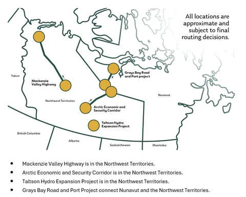
Following and reflecting the Northern Corridor concept, several important projects of national scale such as Mackenzie Valley Highway, Arctic Economic and Security Corridor, Grays Bay Road and Port, and Taltson Hydro Expansion were recently referred to the Major Projects Office of the Federal Government [1, 2].
1.3 Operational Support
The follow-up efforts of the country to deploy the Economic and Security strategy in the North were leveraged by most recent political and economical realities.
Specifically, in February 2026 Canada launched its first Defence Industrial Strategy (DIS) [16, 17] to address the long-term strategic and integrated infrastructure vision for the near-Northern, Northern, and Arctic regions.
A part of this strategy is the Northern Operational Support Hubs (NOSH) program establishing a dispersed network of principal hubs and secondary nodes to provide critical infrastructure and logistical support for military operations in the North [16, 17]. "NOSH emphasizes collaboration with Indigenous partners, northern communities, and regional governments to align military operational requirements with shared regional priorities. By delivering dual-use infrastructure such as airports, seaports, medical capacity, and alternative power generation, NOSH will not only strengthen Canada's defence posture but also enhance community well-being, resilience, and economic opportunity".
Based on well-proven experience of Canada's military in the Arctic and the North, the Northern Operational Support practices may be applied to the major economic hubs and nodes in the Northern Corridor. Multimodal connections with the Northern Corridor hubs would be used to create multi-purpose benefits for communities and support other federal, territorial, and municipal agencies. These connections would also highlight opportunities for selecting, planning, and deploying the next cohort of hubs in the Northern Corridor.
1.4 Clean Electricity Transmission
One of the major economic drivers for deploying the Northern Corridor is defined by clean electricity transmission.
While solar power generation and storage may be utilized locally at the Corridor hubs and nodes, clean electricity from remote large-scale hydro, wind, and geothermal power generation sources has to be effectively transmitted to its users along the Corridor. This is why, when planning the deployment of the Corridor hubs and multimodal connections between them, power transmission is considered an immediate planning step.
As the Northern Corridor concept and the Arctic Economic and Security Corridor Transformative Strategy connect Atlantic, Pacific, and Arctic oceans, clean electricity transmission deployment to make the Canadian North and Arctic regions more resilient presents a very timely and critical task. This task was clearly defined in a new National Electricity Strategy of May 2026 [18, 19] addressing two initial challenges:
- Building new infrastructure to double Canada's electricity supply by 2050 and meet growing demand; and,
- Accelerating electrification across the economy to support competitiveness and address climate change.
The Federal Government is focused on working with provinces, territories, and other partners to expand efforts in several key areas, including:
- Building the electricity system: Constructing a better-connected, modernized system to deliver twice as much affordable, reliable power.
- Increasing regional integration: Establishing a coordinated federal-provincial-territorial framework to advance inter-provincial interties and to encourage greater regional collaboration and coordination.
- Securing the North: Examining existing and new federal supports, including targeted investments for infrastructure, energy planning, and deployment of made-in-Canada technologies (e.g., advanced grid controls and digitalization) that contribute to reliability and affordability in the North.
The National Electricity Strategy is aligned with provincial and territorial transmission integration efforts defined in the National Energy Corridor Agreement [20]. This Agreement presents "a historic effort to connect and strengthen Canada's electricity systems by launching a first-of-its-kind interprovincial-territorial partnership to build transmission infrastructure needed to power the country's next generation of growth".
Understanding that "expanding electricity transmission between jurisdictions is essential to meeting rising demand, strengthening energy security and unlocking the full value of Canada's clean and diverse energy resources", Canadian provinces and territories will collaborate to:
- Identify and advance new interprovincial and territorial transmission infrastructure, including key intertie projects with elevated speed.
- Expand electricity trade within Canada, helping regions meet growing demand and maximize the use of clean, reliable power before exporting abroad.
- Advocate for federal support, including investment to accelerate transmission corridors and an electricity strategy that connects Canada east-west and north-south.
- Partner with Indigenous communities in energy development, ensuring meaningful participation and shared economic benefits.
1.5 Northern Supergrid as a Corridor Core
As Canadian North and the Arctic are the regions of significant geographic and strategic importance, infrastructure development in these regions requires advanced electricity transmission solutions. To ensure international trade in the North and strengthen national security, transmission planning and deployment have to fully cover the "East-West" dimension of the country to bring power to major hubs on the three ocean coasts.
Very long distances between neighbouring Northern Corridor hubs as well as between the hubs in the Northern and Southern Corridors highlight high voltage power transmission as a critical attribute of and a must for the multimodal Northern Corridor infrastructure.
It is important to mention that power transmission spanning thousands of kilometers is not a new practice. The countries with very large land areas rich with clean energy sources (earlier hydropower, and later wind and solar) such as Canada in North America, Brazil in South America, or China in Asia have been historically addressing the need to connect remote supply regions with regions experiencing highest electricity demand.
Today, China is leading the world in installed capacity of remote wind and photovoltaic power; it built the world's largest west-to-east ultra-high voltage (UHV) transmission network [21], making UHV "highways" the core of the country's transmission system and increasingly applying HVDC converter technology [22, 23].
Canada has for many years been presenting its long-distance electricity transmission leadership by delivering hydropower in Manitoba, Quebec, and Newfoundland and Labrador. Because of very successful experience of generating clean electricity in the North and transmitting it to power hubs in the south of the country, Canada today is economically and technologically ready to leverage its leadership in North America by deploying the Northern Corridor's electricity transmission in the sub-Arctic and Arctic.
Having in mind today's needs and realities of the Arctic and Northern regions, including defence infrastructure, transportation, energy, and surveillance [24, 25], and a timely shift toward sustained northern capability, a better look at the "east-west" oriented supergrid within the Northern Corridor increasing transmission capacity and adopting advanced HVDC technology is required.
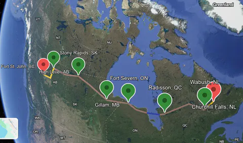
This means prompt deployment of multi-vendor, multi-purpose supergrid infrastructure projects embedding multi-terminal High Voltage Direct Current (HVDC) voltage sourced converter (VSC) technology, with modular multi-level converters effectively handling high voltage and power levels. The "east-west" oriented Northern Supergrid core will connect Atlantic and Pacific coasts, while the supergrid's "north-south" oriented branches will reach the Arctic coast hubs in the north and the transcontinental transmission in the south of the country.
The publication below addresses the key transmission planning aspects of the Northern Supergrid as a core of the Northern Corridor addressing the needs reflected in the National Energy Corridor Agreement and National Electricity Strategy.
The conceptual framework for Canada's Northern Supergrid proposed in this publication is built on two key foundations:
- The engineering research on Canada's Southern Supergrid (see "Towards Canada's Transcontinental Supergrid: AC/DC Transmission Merge Solutions" [39]) addressing HVDC transmission pre-feasibility studies, and
- The Canadian Northern Corridor (CNC) public policy documentation based on the CNC Right of Way concept [7, 8, 9, 10, 11, 12, 13, 14, 15], allowing the author to leverage these foundations and bring the Northern Supergrid framework to the readers' attention.
2. Background and Regional Context
2.1 Current Electricity Targets in the North
2.1.1 Strengthening Clean Energy Economy
British Columbia
Accelerating the shift to clean energy requires opening up new opportunities for communities and supporting the growth of key industries throughout British Columbia (BC) [47]. This includes advanced provincial planning "for an unprecedented level of construction over the next decade" to ensure clean electricity generation growth and building out strengthening BC's electricity transmission grid. In January 2024, BC Hydro announced an increase of 50% over its previous capital plan for community and regional infrastructure investments across the province (see BC Hydro's updated 10-Year Capital Plan to [48]). Current focus on BC Hydro's transmission grid planning is also defined by the need to address BC's net import experience and related issues of growing demand and reliability requirements [49].
North Coast Transmission Line
An important part of BC Hydro's vision addressing the province's major needs is related to the North Coast electrification and economic development.
According to BC Hydro, "The North Coast is seeing significant growth in many areas, including ports, mining, hydrogen, technology and liquified natural gas and the potential demand for electricity exceeds the capacity of the existing transmission system. To support economic development and to meet the growing demand from customers in northwest BC we're proposing to expand our transmission infrastructure by building new transmission lines, upgrading existing lines, expanding or upgrading substations, and expanding capacitor stations.
The proposed transmission system expansion also supports BC Hydro's reconciliation objectives. We are partnering with First Nations on new approaches to infrastructure development, including an opportunity for First Nations co-ownership of the North Coast Transmission Line" [50].
According to the British Columbia Energy Regulator (BCER), BC Hydro is proposing to build the new transmission lines and associated infrastructure from Prince George to Terrace through two phases [51]:
- Phase 1: Prince George to Glenannan Transmission: An approximately line from Williston to Glenannan substation.
- Phase 2: Glenannan to Terrace Transmission: An approximately line from Glenannan substation to Telkwa substation, and an approximately line from Telkwa substation to Skeena substation.
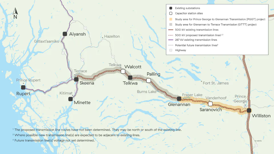
Expected North Coast Transmission Line construction is scheduled to begin in summer 2026 with vegetation clearing, road building, and access development. Transmission line construction is expected to begin in 2027, with the line targeted to be in service by mid-2032. In the Terrace area, early work is expected to include route confirmation in areas such as Thornhill, where final alignment decisions are still being made, as well as clearing and preparation around the Skeena substation [52].
The next possible phase in the development of the North Coast Transmission Line is its expansion to Bob Quinn Lake. Phase 3 is described as being in the planning stage, and a detailed, phase-specific schedule is not yet presented alongside published in-service targets for Phases 1 and 2. Provincial materials indicate construction is expected to begin in summer 2026 for the overall programme, with phased completion targeted between 2032 and 2034, while Phase 3 planning continues and additional improvements beyond Terrace are considered [53, 54].
Yukon-British Columbia Grid Connect
Another major opportunity of the North Coast Transmission Line expansion is related to collaborating in the Yukon-British Columbia Grid Connect project, a proposed high-voltage transmission line connecting the Yukon's isolated electrical grid to the BC Hydro's transmission grid [55].
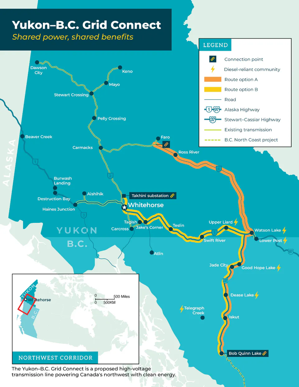
BC Hydro's North Coast Transmission Line project will bring electricity to the doorstep of the Northwest Critical Conservation Corridor in Northwest British Columbia and the Yukon, which was referred to the MPO by the Prime Minister Mark Carney on November 13, 2025 [56].
The Critical Minerals Infrastructure Fund (CMIF) will support the development of critical minerals mines and upstream and midstream supply chains with a focus on getting near-term projects into production, enabling processing and transporting minerals to domestic and international markets [57]. Specifically, the Northwest Transmission Line System Upgrades project has been conditionally approved as of March 3, 2026, pending final due diligence, to support expanded electricity transmission capacity for major mining developments in northwest British Columbia within the Golden Triangle (the Northwest Critical Minerals Conservation Corridor). The project also includes upgrades to the Skeena and Bob Quinn substations and the new Treaty Creek Terminal switching station.
The Yukon-B.C. Grid Connect is a proposed high-voltage transmission line connecting Yukon's isolated electrical grid to BC Hydro's transmission grid through Bob Quinn Lake, B.C. The transmission line will electrify several diesel-reliant communities and significant critical mineral developments in the Yukon and B.C.'s Northwest Corridor [58]. Several prospective transmission line routes were considered and two of them deemed to be feasible: a route from Bob Quinn Lake, B.C. via Watson Lake, YK on the BC-YK border to Ross River, YK, along Highway 37 and the Robert Campbell Highway, and a route from Bob Quinn Lake, B.C. via Watson Lake, YK to Whitehorse, YK, along Highway 37 and the Alaska Highway. The Bob Quinn Lake, B.C. to Watson Lake, YK transmission component's length is about ; the Watson Lake, YK to Ross River, YK transmission component's length is about , and the Watson Lake, YK to Whitehorse, YK transmission component's length is about .
While the Yukon-British Columbia Grid Connect Transmission options are being considered, a multiterminal multilevel HVDC approach may be applied to the BC Hydro's North Coast Transmission Line expansion component connecting the Skeena and Bob Quinn substations (Phase 3, length) and the Yukon-B.C. Grid Connect transmission component between the Bob Quinn and Watson Lake substations ( length), in total. This HVDC approach may also be applied to the Yukon-B.C. Grid Connect transmission components in the Yukon.
Enhanced Geothermal System for Power Generation at Mount Meager, BC
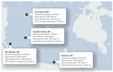
One critical opportunity with emerging clean electricity technologies in British Columbia is related to enhanced geothermal systems (EGS). EGS can provide firm, clean, cost-competitive electricity in western and northwestern Canada, "especially with recent advances in drilling and reservoir stimulation and continued innovation" [59]. Present-day costs and levelized cost of energy (LCOE) estimates for EGS are already competitive with other options for baseload electricity generation, especially in areas with hotter geothermal gradients such as British Columbia (e.g., the potential of an Enhanced Geothermal System (EGS) for Power Generation at Mount Meager, BC [59, 60]). However, EGS technology is often left out of electricity system planning.
Collaboration with the Territories
In May 2025 the governments of British Columbia, Alberta, Saskatchewan, Yukon, Northwest Territories, and Nunavut signed a memorandum of understanding to cooperate on the advancement of economic corridors and shared priorities within the Canadian federation [61].
In May 2025 the Province of British Columbia signed a memorandum of understanding (MOU) with the Government of Yukon to explore and advance the planning of a future connection between the Yukon and British Columbia electrical grids. The Yukon-B.C. Grid Connect would enable two-way transmission of renewable electricity, opening new opportunities to supply clean power to remote and resource-rich areas in northwestern B.C. and the Yukon. The MOU reaffirms B.C. and the Yukon's commitment to Indigenous collaboration, clean-energy development, and regional infrastructure planning that meets the needs of present and future generations [62].
In July 2025 the governments of British Columbia and the Yukon signed a memorandum of understanding on Economic and Labour Mobility Cooperation [62].
Yukon
The Yukon is establishing its northern clean energy economy through addressing several important needs, including providing clean, reliable electricity to the Northwest Critical Mining and Conservation Corridor, increasing the Yukon's energy supply during peak winter demand, electrifying multiple diesel-reliant communities, supporting First Nations ownership and partnership in the energy sector, and reducing the risks associated with major renewable energy projects in Canada's Northwest [58].
The critical mineral deposits that exist in Canada's Northwest are in high demand due to their importance to clean energy technologies, advanced electronics, and the global semiconductor supply chain. The Government of Canada has identified the Northwest Critical Mineral and Conservation Corridor as an area of strategic focus in transforming Canada.
However, the Yukon's grid is currently at capacity, as Yukon's growing demand is outpacing its available clean energy supply. Peak winter power needs currently exceed generated capacity, and new thermal generation is considered a short-term solution.
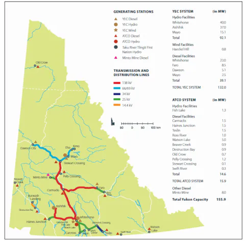
Reliable and affordable clean power is essential to advancing many prospective mining operations in the region, and the Yukon has an initial renewable energy generation potential to address this need. Maintaining, strengthening, and expanding the Yukon's grid, making it flexible and resilient, connecting it to the national electricity grid is required to stabilize winter supply, expand its renewable potential, and create a market to sell surplus clean power to the rest of Canada.
One strategically important and timely way to upgrade the Yukon's grid is the Yukon-B.C. Grid Connect Project demonstrating significant clean economic growth potential is shared equally between B.C. and the Yukon.
The Yukon-B.C. Grid Connect is a proposed high-voltage transmission line connecting Yukon's isolated electrical grid to BC Hydro's transmission grid through Bob Quinn Lake, B.C. The transmission line will electrify several diesel-reliant communities and significant critical mineral developments in the Yukon and B.C.'s Northwest Corridor.
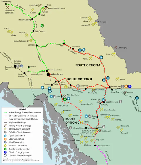
The Memorandums of Understanding were signed between BC Hydro and the Yukon Development Corporation, and between Government of British Columbia and Government of Yukon. The Project completed its pre-feasibility studies in late 2025 [55, 58].
Alberta
According to the Alberta Energy Regulator [64], "Alberta has a competitive advantage over many other geothermal producers globally. Alberta has access to innovative drilling technologies, with a highly developed oil and gas skill set and a robust subsurface data set essential to a successful geothermal industry. There is a potential opportunity to repurpose Alberta's existing wells; geothermal wells can be located alongside oil and gas wells."
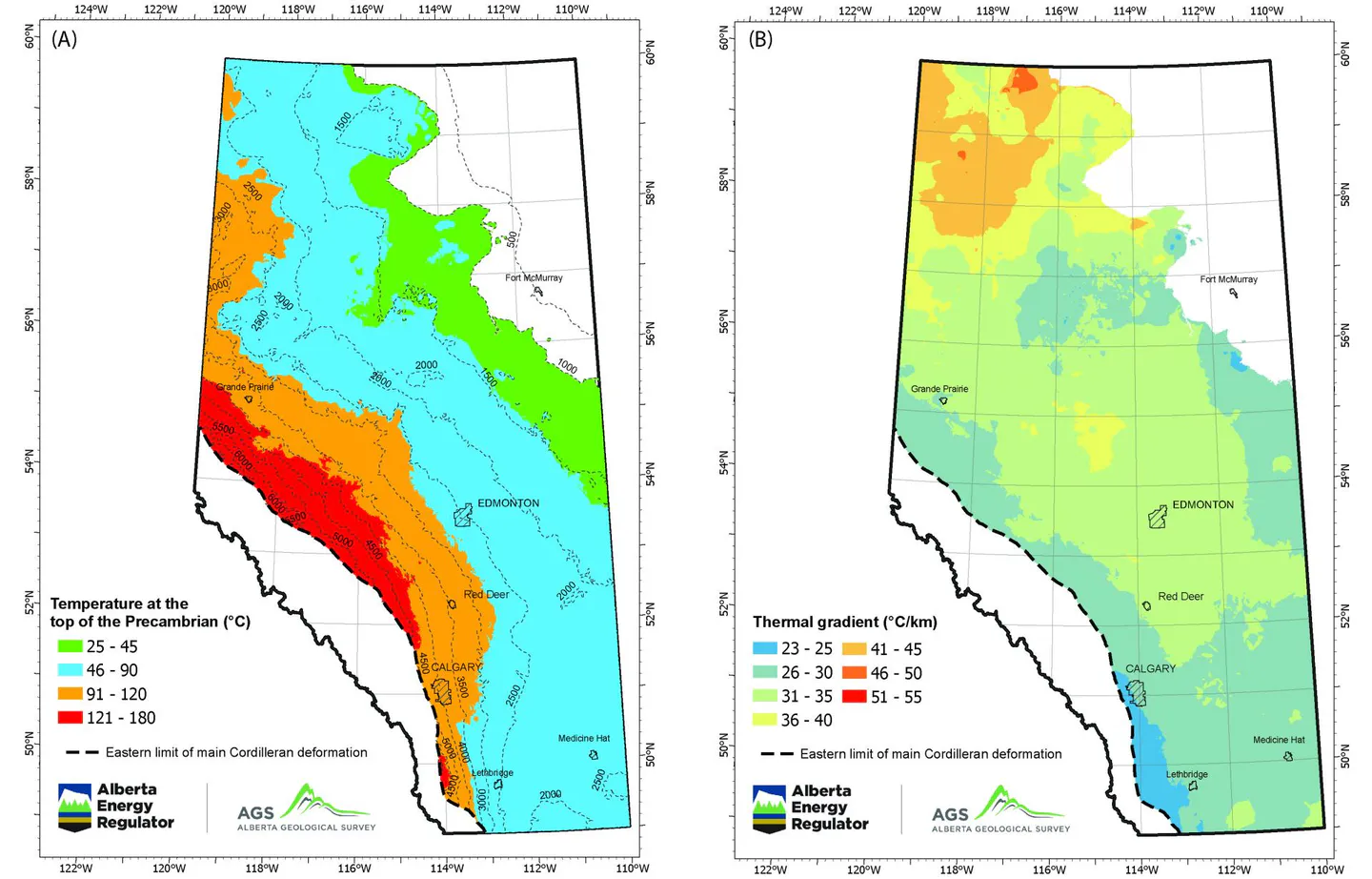
Specifically, advanced geothermal technologies (e.g., enhanced geothermal systems (AGS)) can be used for highly-efficient electricity generation in parts of northwestern Alberta where the temperatures at the top of the Precambrian basement rock are expected to exceed while demonstrating a high thermal gradient over for AGS to be economically viable and efficient [64, 65, 66].
This opportunity allows for considering the Town of High Level, a key part of the Northwestern Alberta Regional Economic Development Initiative, to become a competitive Alberta's geothermal electricity generation hub closely connected to a Northern Supergrid converter station in Alberta.
Collaboration with the Territories
In July 2024 the governments of Alberta and the Northwest Territories signed an agreement to collaborate on economic corridors projects "to support growth and development in both jurisdictions. The agreement includes working co-operatively to enhance critical infrastructure and improve the efficiency of interjurisdictional transportation networks. This partnership will help enhance Alberta's access to the Arctic, which could open up opportunities to expand exports in key sectors" [67].
In July 2025 the governments of Alberta and Yukon signed a memorandum of understanding to improve economic cooperation and labour mobility [68].
Northwest Territories
Climate change is warming the Northwest Territories (NWT) up to four times faster than the global average. This affects permafrost, shorelines, transportation, and the safety and well-being of the NWT communities. It also presents major industrial and economic opportunities such as clean electricity generation (including enhanced geothermal systems) and mining of critical minerals [69, 70].
The Future of Energy in the NWT brings together the work happening now across communities, Indigenous governments, Indigenous organizations, and businesses [69]. An important part of this work is power grid modernization through Integrated Power System Planning (IPSP), a territory-wide planning process led by the Public Utilities Board (PUB) and carried out by the NWT's electric utilities [71, 72, 73, 74].
Interconnection of the major transmission grids in NWT as well as interconnection of the Taltson grid in the South Slave region with the inter-provincial Electricity Grid through the Taltson Hydro System present a critical economic and political target for the Northwest Territories.
Taltson Hydro Power Expansion and Taltson-Snare Hydroelectric System Integration
Taltson River Basin's Hydro power generation potential
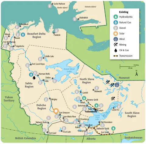
The Taltson River flow starts from the river's upper reaches in the northeast of the river basin, and finishes with its lower reaches emptying into Great Slave Lake about east of Fort Resolution [75]. In its middle course the river flows through a series of lakes, low-gradient reaches, rapids, and waterfalls, presenting hydro power generation opportunities. The Taltson hydro system generation potential is assessed at the level [75, 76, 77, 78].
The Taltson Expansion project
On January 23, 2019 the Federal Government and Northwest Territories announced joint investment in the Taltson Hydroelectricity Expansion Project to expand green energy infrastructure in the Northwest Territories and provide clean power to Yellowknife [79]. The initial expansion will increase capacity from to and link it to the Snare hydroelectric system near Yellowknife through a High Voltage Direct Current submarine cable across Great Slave Lake. The federal and territorial investments in the Taltson Hydroelectricity Expansion project supported Indigenous engagement and funded initial engineering work.
On March 12, 2026 during a press conference in Yellowknife Prime Minister Mark Carney referred the Taltson Hydro Expansion Project to the Major Projects Office [1] highlighting the Taltson Project expansion as a key to providing Yellowknife and other communities on the grid with "reliable, clean electricity" and a "force multiplier" for the territory's economy [80].
The Taltson project is a part of an all-in-one critical infrastructure corridor, covering transportation, energy, and communications, that is expected to provide clean hydro energy to the mineral-rich Slave Geological Province [75].
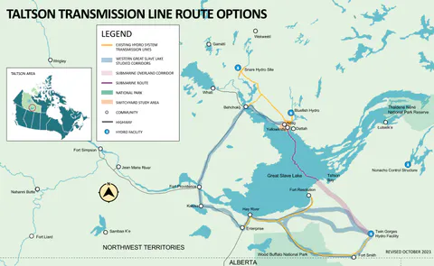
The Taltson hydro system expansion adds of hydropower generation to the existing facility at Twin Gorges Forebay. The Taltson Project also includes a new transmission line into the Yellowknife area connecting the Taltson hydro system with the Snare system north of Great Slave Lake. Once built, an integrated hydro system connecting the Snare system and the Taltson hydro system will stabilize electricity transmission to ten communities and over 70% of the NWT population.
The current Taltson System Transmission Expansion opportunities can be summarized as follows:
- Historically, the Taltson hydro system includes transmission lines to bring electricity via Fort Smith to Enterprise, Hay River, Hay River Reserve, Fort Resolution, and K'atlodeeche First Nation [76].
- Two technically viable transmission routes for the Taltson project currently being considered are:
- An approximately line, following existing highways around Great Slave Lake, and
- An approximately line from Twin Gorges to Yellowknife, with of overhead transmission and of submarine HVDC cable [75].
- A key component of the current Taltson hydro system is the substation at Pine Point located between Hay River and Fort Resolution and belonging to the Pine Point Project. From its inception to its growth, decline, and future prospects, this project has played a pivotal role in shaping the landscape of mining operations [84]. Today, the proposed Pine Point mine site features primary infrastructure such as paved highway access, an electrical substation, and of operational haulage roads.
- Another viable overhead transmission sub-option considered for the project may include an upgraded transmission from the extended Taltson Hydro generation facility via the Fort Smith and Pine Point substations to Fort Resolution and further extending it to the location of the HVDC converter on southern Great Slave Lake (South Slave region).
- The existing substation site at Pine Point may also be considered as a candidate location for installing an HVDC converter of the transmission branch to connect the Taltson hydro system with the Northern Supergrid converter at High Level, Alberta.
- This HVDC transmission branch between the AESO transmission system and the Taltson hydro system would leverage the efforts of the Taltson Hydro Expansion Project addressing Phase 3 of the project [75, 83] and connecting the Taltson grid to the inter-provincial transmission grid.
- Location of the HVDC power converter at Pine Point is seen as strategic based on its transport infrastructure support approach, connecting Alberta Highway #35 at High Level, AB directly northward via Northwest Territories Highways #1, 2, 5 and ending at Pine Point at Highway #6 (Fort Resolution Highway).
Arctic Economic and Security Corridor
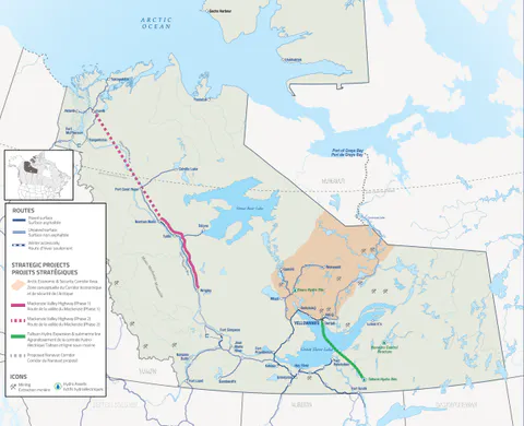
The Arctic Economic and Security Corridor project is a proposed all-season gravel road running roughly north-northeast from the end of the existing Tibbitt(NT)-to-Contwoyto(NU) winter road system into the central Slave Geological Province, then onward to the Nunavut border [85]. The Arctic Economic and Security Corridor Project proposal was referred to the Major Projects Office by Prime Minister Mark Carney on March 12, 2026 [1].
The corridor opens year-round access to a string of advanced mineral exploration and development projects related to copper, gold, zinc, and cobalt. Supported by the Taltson Hydro Expansion, the corridor could help deliver clean, reliable energy to northern communities and industries while reducing reliance on diesel [86].
In coordination with the Grays Bay Road and Port project in Nunavut, also referred to the Major Projects Office by Prime Minister Mark Carney on March 12, 2026 [1], the Arctic Economic and Security Corridor strengthens Canada's Arctic sovereignty and defence by enhancing Canada's long-term presence and connectivity in the North and opens new opportunities for northern communities and Canadian industry.
As the corridor crosses the territories of the Tłı̨chǫ Government, the Yellowknives Dene First Nation, and the Łutsël K'é Dene First Nation, they partnered with the Government of the Northwest Territories to advance the Arctic Economic & Security Corridor [87].
Mackenzie Valley Highway
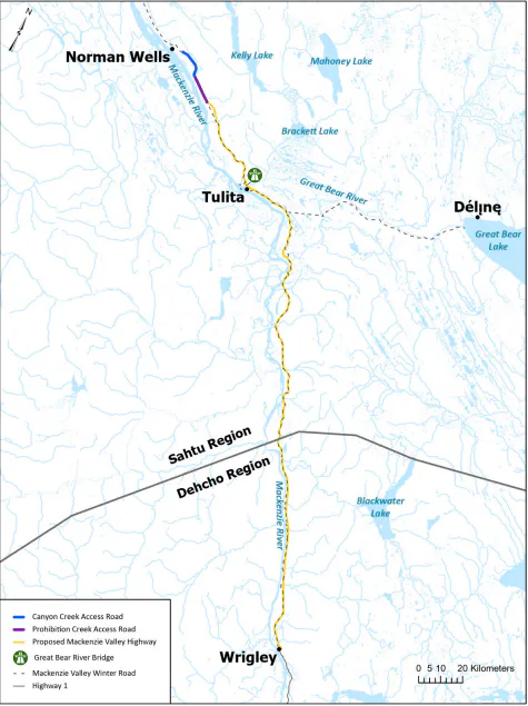
The Mackenzie Valley Highway (MVH) Project [88] presents an long all-season highway connecting Yellowknife and Inuvik and opening up commercial opportunities along the route. The project, referred to the Major Projects Office by Prime Minister Mark Carney on March 12, 2026 [1], will establish a critical transportation corridor into Canada's Arctic and provide essential year-round access to Indigenous and remote communities in the Mackenzie Valley. This will open the Sahtu and Dehcho regions to mineral exploration and support Canada's arctic sovereignty and security operations in the Inuvik Region.
Phase 1 of the MVH Project proposes to replace approximately of the seasonal Mackenzie Valley Winter Road by extending all-season road access from the end of Highway 1 at Wrigley, to Tulita and Norman Wells. Phase 2 would extend the highway from Norman Wells via Fort Good Hope to Inuvik.
Saskatchewan
Saskatchewan's First Energy Security Strategy and Supply Plan of October 2025 [90] highlights the following:
- Focus on the expansion of transmission networks to strengthen energy security and electricity export capacity within the provincial Energy Security Strategy and enhance transmission infrastructure to power economic growth and exports [90, 91, 92, 93, 94].
- A key focus of SaskPower's transmission strategy for the province's Far North aimed at facilitating growth in the mining sector and enhancing reliability.
- Expansion of SaskPower's transmission infrastructure according to its Far North Transmission System Reinforcement Strategy to serve new and prospective mining developments (e.g., in the Patterson Lake region).
- Interprovincial transmission infrastructure with Alberta and Manitoba to enhance the resilience of the provincial electrical grid and enable export of excess power.
Collaboration with the Territories
Saskatchewan is collaborating with B.C., Alberta, Manitoba, Yukon, Northwest Territories, and Nunavut to accelerate development, enhance supply-chain resilience, diversify export markets, and strengthen the position of Canada's west as a preferred global supplier of responsibly sourced critical minerals.
The MOU to jointly advance a Western Canadian Critical Minerals Strategy signed on January 25, 2026 established a framework for co-operation to promote Western Canada as a global hub for critical minerals innovation and sustainable development, prioritize regional critical mineral hubs, and identify the infrastructure planning and investment needed to maximize mineral extraction, processing, and export capacity [95].
Manitoba
A leader in developing one of the cleanest and greenest electricity systems in the world, Manitoba maintains clean energy as a major cornerstone of the province's economy. Manitoba's clean energy strategy "focuses on building new generation hydro; expanding transmission that improves electricity reliability and security; adding more wind power as economics allow; promoting geothermal, biomass and solar for heating needs; developing our biobased fuels; and leading in new cutting edge electric transportation solutions" [96].
Realizing this strategy, on April 14, 2026 the new Co-operation Agreement between Manitoba and Canada on Environmental and Impact Assessment was announced. The new Co-operation Agreement will help accelerate major infrastructure projects across Manitoba, including the Port of Churchill Plus project to establish a reliable trade corridor in the North, enabling Canada to export more resources to European markets. This project would modernise the Port of Churchill by advancing potential improvements, such as an all-weather road, rail line enhancements, a new energy corridor, and strengthened marine ice-breaking capacity [97].
Collaboration with the Territories
On April 16, 2025 the Governments of Manitoba and Nunavut signed a joint statement declaring their commitment to advance the Kivalliq Hydro-Fibre Link (KHFL), a vital energy and communications corridor connecting the two regions [98]. This strategic initiative aims to drive economic development, support reconciliation, combat climate change, and strengthen Canada's Arctic security. The KHFL is a transmission project that will enable renewable power transmission and fibre-optic internet connectivity to communities and the economy in the Kivalliq region of Nunavut, by connecting into Manitoba Hydro's power grid.
Nunavut
Nunavut is the largest and northernmost of 13 provinces and territories of Canada with a total landmass of [99, 100]. Nunavut's energy strategy (Ikummatiit) is focused on promptly reducing its dependency on fossil fuels and creating an energy system that is affordable, sustainable, reliable, and environmentally responsible [101]. While today diesel fuel remains the backbone of Nunavut's energy system [102], development of renewable energy sources such as hydro, wind, and solar power present a key energy transition component of Ikummatiit.
Nunavut's energy system is unique to all other provinces and territories in Canada [102, 103]. There are no regional or territorial electricity grids in Nunavut. There are also no transmission lines enabling the trade of electricity between Nunavut and other jurisdictions. All electricity generation is community based and cannot be shared between communities. Qulliq Energy Corporation (QEC), owned by the Nunavut government, operates 25 diesel plants in 25 communities and is responsible for generation, transmission, and distribution of electricity in Nunavut.
Canada's Sovereignty in the Arctic
As the Arctic is increasingly becoming a region of security, competition, and risk on the global stage, Canada's sovereignty requires strong support of and collaboration with Nunavut and its First Nations and communities. Economic security forms the foundation of Arctic sovereignty; healthy, prosperous communities with meaningful employment opportunities and strong cultural connections represent Canada's most effective assertion of sovereignty [104].
Nunavut-Manitoba All-Season Highway Exploration
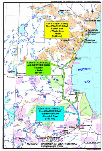
In 2007, a two-year Nunavut-Manitoba All-Season Highway multidisciplinary study commissioned by the Kivalliq Inuit Association together with the governments of Nunavut and Manitoba was completed. The study determined the best location for a road route linking the community of Rankin Inlet, NU to the Port of Churchill, MB and the existing all-season road transportation network in Manitoba with the recommendation of a preferred route connecting Rankin Inlet to Manitoba Provincial Road 290 [105] at Sundance, MB (see Figure 13). According to the study, the preferred route would provide the most effective, safe, and reliable route from Rankin Inlet, Whale Cove, Arviat, and Churchill to Manitoba's all-season road network in light of its length, terrain, lowest construction and maintenance costs, and ease of staging, and would bring significant social and economic benefits to the northern communities in Manitoba and Nunavut.
In 2010 a Business Case Study for the proposed Nunavut-Manitoba all-season highway was completed to provide decision makers and stakeholders with a clear understanding of the value, risks, and priority of the highway development [106].
Kivalliq Inter-Community Road Project
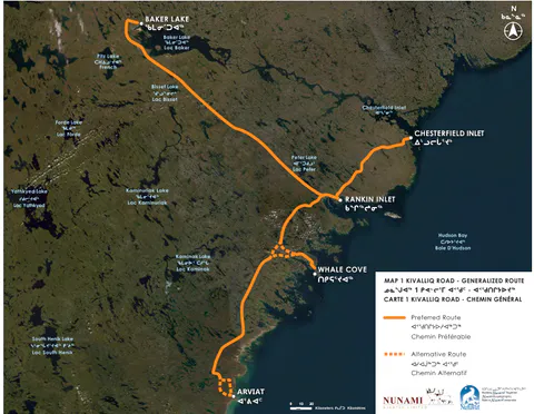
Currently, the Government of Nunavut is doing a study of a potential all-season inter-community road connecting five communities in the Kivalliq region of Nunavut. This road would run over between Arviat, Whale Cove, Rankin Inlet, and Chesterfield Inlet along the west coast of Hudson Bay. It would also run to Baker Lake, located inland [107].
A preferred route for the Kivalliq Inter-Community Road was identified based on the draft Nunavut Land Use Plan and information about permafrost, slopes, ground conditions, and the location of rivers, lakes, and wetlands. The proposed and alternative connecting roads into each community were also identified [107, 109].
Kivalliq Hydro-Fibre Link
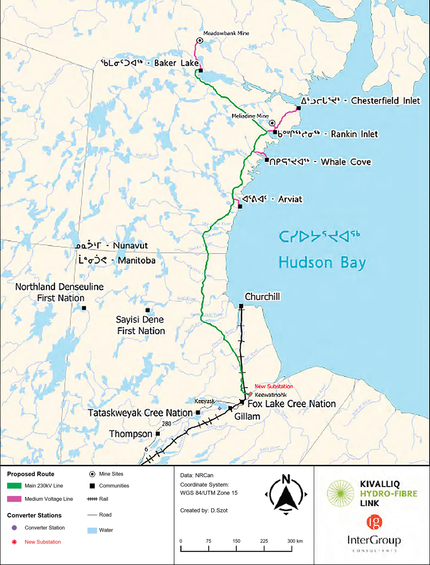
The Kivalliq Hydro-Fibre Link project promoted by the Kivalliq Inuit Association in Nunavut would put in place the critical infrastructure needed for sustainable economic growth, energy security, and digital connectivity in the Arctic [110, 111, 112, 113, 114, 115, 116, 117]. This transformative project is supported by the Governments of Nunavut and Manitoba, Nunavut Tunngavik Inc., the Canada Infrastructure Bank, Qulliq Energy Corporation, Manitoba Hydro, and Agnico Eagle Mines [113].
The project proposes construction of a electricity transmission line and a high-speed fibre optic line from Manitoba Hydro's power grid to five western communities and two Agnico Eagle mines in the Kivalliq region of Nunavut. The project would be Nunavut's power infrastructure link to southern Canada and would support future mineral exploration and development in the region. It would also offer fibre-optic connectivity, delivering high-speed internet service [114, 115].
With of renewable electricity and fibre bandwidth in its capacity, the project would enable growth by providing the essential power and communications backbone for northern industries, communities, and future development of the Kivalliq region. It would replace costly diesel generation with reliable renewable power and bring high-speed fibre connectivity to remote communities and strategic mineral regions.
Grays Bay Road and Port Project
The Grays Bay Road and Port (GBRP) is a proposed all-season road of approximately from the Nunavut border to a deepwater port and airfield at Grays Bay, on the strategic Arctic Ocean. The project includes a deepwater export terminal for minerals and an airstrip, which will both have dual-use civilian and military potential. The GBRP Project proposal was referred to the Major Projects Office by Prime Minister Mark Carney on March 12, 2026 [1].
The Grays Bay Road and Port is a multimodal, multi-purpose, multi-user asset that will further assert Inuit and Canadian sovereignty over the Northwest Passage [118].
Grays Bay is well placed to serve as a hub for Canadian and allied naval sovereignty patrols in the Western Arctic, as well as Coast Guard patrols and Search and Rescue missions. The Grays Bay Port's location, directly on the increasingly contested Northwest Passage, will be of significant strategic value.
The project will also accelerate economic growth in the Kitikmeot region by dramatically improving access to critical mineral deposits, such as Izok Lake, Hackett River, and High Lake. The viability of these critical minerals deposits will be enhanced by co-occurring gold and silver by-products, as well as shared infrastructure with precious metals deposits such as Back River and Ulu.
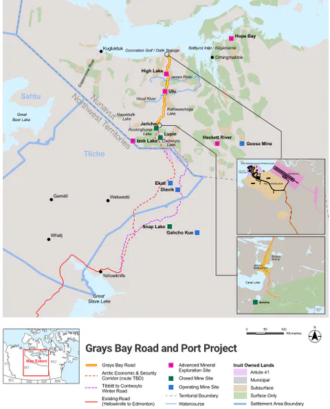
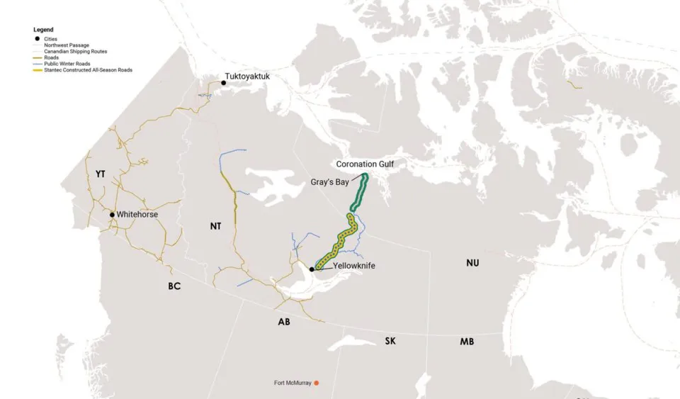
The Grays Bay Road presents a vital transportation infrastructure corridor between southern Canada and the Kitikmeot region. This all-season road will connect Grays Bay with the northern terminus of the Tibbitt to Contwoyto Winter Road north of Contwoyto Lake close to the Nunavut border. The southern terminus of this winter road is located near Tibbitt Lake about northeast of Yellowknife, NT (see Figure 16). The Contwoyto terminus will then connect Nunavut to the national highway system via the Northwest Territories' Arctic Economic and Security Corridor, a proposed all-season road of approximately to Tibbitt Lake, NT and further via Northwest Territories Highway 3 (the Yellowknife Highway [120]) and Highway 1 (the Mackenzie Highway [121]) to Alberta.
Together, the Grays Bay Road and Port and the Arctic Economic and Security Corridor projects will create Canada's first overland connection to a deepwater port on the Arctic Ocean. They will connect strategic mineral deposits to national road networks and tidewater linking Canada's North to new global markets and ensuring reliable access to Canadian minerals. The Grays Bay Road and the Arctic Corridor Road infrastructure will also allow for considering and planning high voltage power transmission along the roads to connect the integrated Snare (North Slave) and Taltson (South Slave) power grids in Northwest Territories and provide electricity to Nunavut for critical minerals mining in the region and naval and security operations at the Grays Bay Port.
Ontario
The Prosperity and Growth Strategy for Northern Ontario [123] is focused on mining and forestry as its primary sectors. The region's economic growth is particularly vulnerable to global economic cycles, and energy security and access to clean electricity are of critical importance to its communities presented by 150 municipalities and 106 First Nations [123, 124, 125]. Of these communities, 28 are unconnected and accessible only by air travel, or a combination of air travel and alternate modes of travel such as winter roads, when conditions allow. Almost all fly-in communities (27 out of 28) are First Nations, and the majority are located in the northwestern region. The greater distances between communities lead to higher costs of doing business, developing infrastructure, and accessing basic services [123].
The Prosperity and Growth Strategy unlocking Northern Ontario's full potential outlines priorities and actions across three areas: building Northern Ontario strong, growing companies and markets, and innovation to drive productivity. All these priorities and actions require access to clean electricity and the growth of related transmission grid.
Today, Ontario is building a stronger north-south electricity transmission infrastructure backbone, taking significant steps to support the expansion of transmission infrastructure across northern Ontario. These projects will increase transfer capacity across the North, open the door to new generation, and support the region's growing industrial base. Access to reliable electricity across northern Ontario "is seen essential to support local communities, including First Nations, and enable greater economic self-determination...It will also lay the groundwork for expanded mining activity, new energy development and future transmission connections further north" [184].
An important target for enabling future connections to remote areas is the planned Greenstone Transmission Line [185, 186], unlocking the Ring of Fire—a significant deposit with vast reserves of critical minerals [187] located in the remote James Bay Lowlands of Northern Ontario. According to the province, the Greenstone Transmission Line "is a critical first step toward enabling future transmission expansion into Ontario's Far North, including potential grid connection to diesel-dependent remote First Nations and the Ring of Fire region".
In response to a request from the government of Ontario to develop transmission options in Northwest Ontario, the province's Independent Electricity System Operator (IESO) has been conducting the Northern Ontario Connection Study (NOCS) [126, 127] to:
- Connect remote First Nations communities to the grid that currently rely on diesel generators for electricity.
- Improve reliability for First Nation communities that are already grid-connected.
- Support critical minerals mining development.
- Enable the development of new hydro and renewable resources.
The IESO is currently studying related long-term opportunities in a geographic area over in size—through the Greenstone-Marathon electricity planning subregion up to Fort Severn in the far north.
A great advancement in strengthening the northwestern region's transmission grid was recently made by the Wataynikaneyap Transmission Project [128] to connect remote First Nations communities.
There are 25 recognized First Nations communities in Northwestern Ontario with a combined on-reserve population of approximately 15,000 people, and with a peak electricity demand of approximately . Both population and electricity demand have been growing faster than other regions of Ontario.
The communities are dispersed along an arc starting from approximately north of Red Lake to about east to Pickle Lake. These communities were considered remote because most do not have all-season road access and/or they are not connected to the IESO-controlled grid. None of the communities north of Red Lake and Pickle Lake had access to all-season transportation or utility corridors. The Wataynikaneyap Transmission Project has successfully connected 17 of the 27 communities to the provincial grid and a feasibility study is currently underway to connect one more.
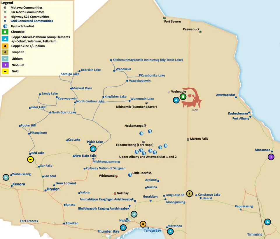
The next step is focused on strengthening access of the communities of the northwestern region to clean electricity and increasing transfer capacity and transmission between northwestern and northeastern regions, and between Northern and Southern Ontario (see the IESO's North-South Transmission Reinforcement Plan [129, 130, 132, 133]).
Collaboration with the Territories
National Energy Corridor Agreement (March 2026): Ontario initiated a landmark, first-of-its-kind partnership with provinces and territories, including Yukon and the Northwest Territories, to build a national electricity corridor. This agreement focuses on building transmission infrastructure, strengthening interties, and enhancing energy security to meet rising demand across Canada [20].
Yukon Nuclear Partnership (April 2026): Ontario and Yukon signed a partnership agreement to deploy Small Modular Reactors (SMRs) in the Yukon. This deal involves Ontario Power Generation and Yukon Energy collaborating on planning and sharing expertise in nuclear energy, regulatory frameworks, and supply chains [131].
Quebec
The province of Quebec is currently deploying its Northern Action Plan 2023–2028, a government strategy developed with partners in the northern territory north of the parallel to address economic, social, and environmental development issues in Canada's North, and to contribute to the vitality and prosperity of the communities that inhabit it [134, 135].
The key directions of the Northern Action Plan:
- Increase connectivity to the territory,
- Build on northern economic strengths,
- Stimulate community vitality, and
- Preserve a unique environment.
Specifically, this pursues the installation of telecommunications infrastructure and optimizes logistics and transportation throughout the northern territory by:
- Finalizing deployment of high-speed Internet in Nunavik,
- Continuing deployment of cell phone service in Eeyou Istchee and James Bay close to the James Bay coast,
- Continuing to upgrade roads between Schefferville and Kawawachikamach close to the Newfoundland and Labrador border.
In January 2026 an investment of $33.4 million was announced to support 25 significant projects in Quebec's northern region. The economic benefits of these projects, including contributions from developers and partners, total $167.6 million [136]. The projects are mostly focused on the operations and life of northern communities as well as mining and industrial infrastructure. Related upgrades are supported by the Enveloppe nordique d'infrastructures en appui au secteur minier (ENIAM), a Québec government initiative designed to provide financial support for strategic infrastructure projects in the northern territory of the province [137], including the operations close to James Bay and St. Lawrence River.
Clean Power
In May 2025, Makivvik and Hydro-Québec signed a landmark collaboration agreement to strengthen relationships and boost economic development in Nunavik. This agreement focuses on advancing renewable energy projects and decarbonizing northern villages of Nunavik [138, 139, 140].
As a follow-up to the electricity supply contracts already signed, two wind energy projects have started to contribute to the decarbonization of the northern villages of Quaqtaq and Puvirnituq and improve the quality of life of these Inuit communities.
Communications Technology Deployment
As of 2026, the core satellite communications technology and service in Quebec are based on Low-Earth Orbit (LEO) satellites. Starlink LEO service has a dominant position in Nunavik for households and small organisations while Telesat Lightspeed, a Canadian operator backed by the federal and Quebec governments, provides an advanced LEO network for larger companies and government users.
The LEO service features include 30–50 milliseconds latency (making videoconferences and telesurgery usable) and downstream speeds of on average [141].
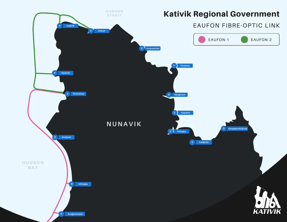
Meanwhile, the Eastern Arctic Undersea Fibre Optic Network (EAUFON) multi-phase project has been in deployment since 2019 to connect 14 Nunavik Communities with reliable, dependable, and affordable High-Speed Fibre Optics connectivity [142].
The EAUFON 1 phase including submarine fibre and terrestrial fibre on Hudson Bay was activated in June 2022. The EAUFON 2 phase including submarine fibre and terrestrial fibre on Hudson Strait was activated in February 2024 [142]. The terrestrial subcomponents of both phases are still in progress. The EAUFON 3 phase ( submarine fibre) towards Ungava Bay is still in planning [143].
Regional Collaboration: Nunavik, QC
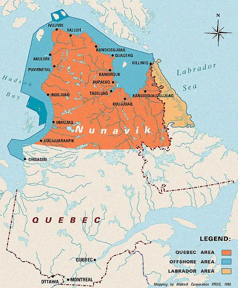
The region of Nunavik as a vast Arctic territory covers close to 444 thousand square kilometres of Northern Quebec shaped by the coasts of Hudson Bay, Hudson Strait, and Ungava Bay. It represents fourteen villages that are not physically connected by land with other villages or with southern Quebec [145].
Regional Collaboration is coordinated by the Kativik Regional Government administering the region of Nunavik, and the Government of Quebec.
Newfoundland and Labrador
While Newfoundland and Labrador has an abundance of renewable energy resources allowing the province to meet its net-zero commitments, the energy sector is currently heavily focused on advancing the $20-billion Bay du Nord offshore oil project toward a 2027 construction start, while simultaneously pushing forward with green hydrogen and wind projects.
Based on a series of oil discoveries in 2013 in the Flemish Pass Basin, about northeast of St. John's, Newfoundland and Labrador, the Bay du Nord project represents a generational opportunity for Canada's offshore. In partnership with Equinor and BP it will open a new deepwater basin and shape the province's energy industry for decades to come [147, 148, 149].
Meanwhile, the province is diversifying its energy mix by the efforts of the Newfoundland and Labrador wind-to-hydrogen industry. The two leading projects as of May 2026 are:
- North Atlantic Wind to Hydrogen Project: Located in eastern Newfoundland, the Placentia Bay and Trinity Bay regions and based on onshore wind power generation to produce green hydrogen for export to global markets [150];
- Botwood and Area EVREC Green Energy Project: A onshore wind energy project consisting of three wind farms with up to 530 turbines in the Central Newfoundland area, and a solar farm and a hydrogen/ammonia production facility in Botwood, NL [151].
Another strategic opportunity strengthening energy security in Newfoundland and Labrador is related to critical minerals extraction and processing based on the rich iron ore deposits of the Labrador Trough. High-purity iron ore is a critical mineral essential to green steel making and decarbonization in Canada [152, 153, 154].
Having a strong industrial base, the Labrador West region is strategically situated to take advantage of developments throughout Labrador and Northern Quebec. As a provincial gateway, Labrador West presents a strategic distribution center, supported by a year-round air, ground, and rail transportation network connecting to the port facilities in Baie-Comeau and Sept-Îles, Quebec and Happy Valley-Goose Bay, Newfoundland and Labrador [155]. As a part of the Labrador West regional upgrade, a transmission line between Churchill Falls and Labrador West has been planned [156, 157].
Collaboration with the Territories: Nunavut
In February 2023, Newfoundland and Labrador and Nunavut signed a Memorandum of Understanding (MOU) to strengthen collaboration on Arctic development, which updated a previous 2015 partnership to strengthen areas of collaboration, partnership, and future development. "As Northern neighbours, the people of Newfoundland and Labrador and Nunavut have personal, cultural and social relationships that have led to collaboration and partnerships. Both jurisdictions have strong Indigenous populations and share a like-minded approach to safe and sustainable Arctic development, focused on achieving mutual benefits for Northern and Indigenous communities" [158, 159, 160].
2.1.2 Exploring Electricity Futures
According to the new National Electricity Strategy [19], a major and very significant part of electricity generation and consumption growth within the 2050 timeframe will be planned for the North of both Western and Atlantic Canada.
In Western Canada, power generation growth will address electricity demands of the four provinces: British Columbia, Alberta, Saskatchewan and Manitoba, and support access to electricity in the neighbouring northern territories: the Yukon, the Northwest Territories and Nunavut.
In terms of electricity supply, the Western Canada generation capacity will include nuclear generation producing low-carbon electricity for baseload, and a bridging/transition resource - natural gas-based power generation plants providing dispatchable capacity to meet peak demand and balance variable renewable generation.
In addition to upgrading renewable resources such as large hydro major renewable sources in the North, growing enhanced geothermal generation will be deployed.
In terms of demand, it is also expected that a considerable part of electricity use in Western Canada will be presented by large electricity loads (e.g., AI data centres, industrial mining facilities, etc.) also located in the provincial North.
According the Canada Energy Regulator (CER)'s Energy Futures 2026 [181], the following electricity demand, generation and generation capacity is expected in Western Canada and in the territories within the 2025-to 2050 timeframe (see Tables 1 and 2 below.)
Table 1: Electricity Generation and Demand in Western Canada (total).
| Western Canada | 2025 | 2030 | 2035 | 2040 | 2045 | 2050 |
|---|---|---|---|---|---|---|
| Electricity Generation, GWh | 214,961 | 246,743 | 285,072 | 331,271 | 376,260 | 413,572 |
| Electricity End-Use Demand, GWh | 186,560 | 216,316 | 250,471 | 289,916 | 330,078 | 366,047 |
| Electricity reserve, GWh | 28,401 | 30,428 | 34,601 | 41,355 | 46,182 | 47,524 |
| Electricity reserve, % | 13.2% | 12.3% | 12.1% | 12.5% | 12.3% | 11.5% |
Table 2: Electricity Generation and Demand in the Canadian Territories (total).
| Canadian Territories | 2025 | 2030 | 2035 | 2040 | 2045 | 2050 |
|---|---|---|---|---|---|---|
| Electricity Generation, GWh | 1,501 | 1,764 | 1,847 | 1,939 | 2,041 | 2,223 |
| Electricity End-Use Demand, GWh | 1,514 | 1,794 | 1,883 | 1,975 | 2,122 | 2,367 |
| Electricity reserve, GWh | -13.1 | -30.7 | -36.0 | -35.7 | -81.1 | -143.3 |
| Electricity reserve, % | -0.9% | -1.7% | -1.9% | -1.8% | -4.0% | -6.4% |
The data presented in Tables 1 and 2 relates to Higher Scenario in the Canada's Energy Future 2026 report modeling an upper-range outlook where economic growth, industrial expansion, and commodity prices outpace the baseline Current Measures scenario.
The data indicates that while the electricity reserve in Western Canada will grow considerably (from 28,401 GWh in 2025 to 47,524 GWh in 2050), it will present a lower share of electricity generation available (11.5% in 2050 versus 13.2% in 2025).
The electricity reserve in the Canadian territories is shown as negative (electricity demand outpaces available generation) and may require support from the neighbouring provinces in Western Canada.
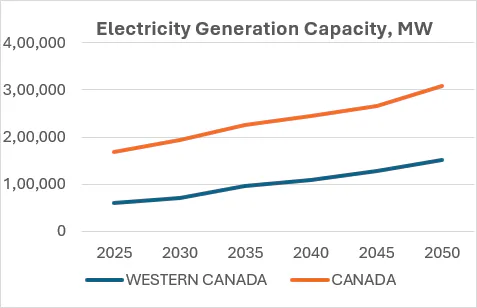
Electricity Generation Capacity in Western Canada (in MW) is shown in Fig. 21. It indicates the growing capacity share in Canada (from 35.15% in 2025 to 48.85% in 2050) with its ability to support growth in the North and the Arctic.
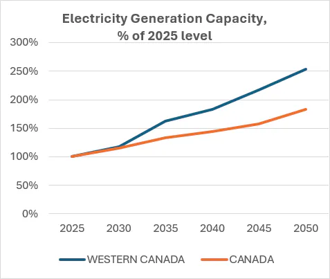
b) The growth of capacity share in % as compared to 2025
Figure 21: Generation capacity share growth in Western Canada.
Addressing both electricity generation and consumption growth in Western Canada and the Territories requires power transmission infrastructure deployment in the North as a critical part of the National Electricity Strategy.
In Atlantic Canada, a historic agreement to upgrade and expand the Churchill Falls Generating Station and develop the Gull Island project and related transmission was announced on August 17, 2026 by the Federal Government and the provinces of Newfoundland and Labrador and Québec [182, 183]. The agreement will bring 14 GW of clean, renewable power generation nearly tripling the current generating capacity of Churchill Falls.
Specifically, the following upgrades will be developed:
- Churchill Falls generation upgrades: Expand and extend the lifetime of the existing Churchill Falls strategic electricity generation facility to increase capacity by 1,275 megawatts (MW), a 30% efficiency increase for existing turbines. The Churchill Falls expansion will increase capacity by up to 2,500 MW.
- Gull Island generation: Construction of a new 2,700 MW hydroelectric facility located on Churchill River between Churchill Falls and Muskrat Falls. The project is expected to be online between 2036-2037 and will substantially increase reliable electricity supply for Atlantic Canada and Central Canada.
- Onshore Wind generation: Proposed development of 2,000 MW of onshore wind in Labrador, with location and other details under consideration by Newfoundland and Labrador Hydro.
- Power Transmission for the Churchill River projects: Construction of transmission lines (660km+) and power infrastructure to enable Churchill Falls and Gull Island to deliver electricity to the Hydro-Québec transmission grid [56].
- Labrador West Transmission: As the existing transmission line serving Labrador City and Wabush / Labrador Trough region are running at maximum capacity, construction of a new 735kV transmission line from Churchill Falls to Labrador City and Wabush to support critical minerals mining/industrial operations in Labrador Trough region.
Related strategies and planning of all Canadian provinces and territories reviewed in section 1 allow for establishing a major next step in developing multimodal corridors with new critical infrastructure in the North.
2.2 Multimodal Corridors
2.2.1 Trade Diversification Opportunity
Canada's Northern and Arctic economic and security corridors developing/deploying critical infrastructure and facilitating trade with non-traditional/global partners present a significant trade diversification opportunity [26, 27]. These multimodal corridors aim to reduce reliance on single-market trade, bolster supply chain resilience, and create new, efficient routes to global markets. The corridors' dual-use infrastructure serves both security and economic purposes protecting national sovereignty and strengthening a gateway for new international commerce. Long-term resilience of the Northern and Arctic corridors will enable alternate trading routes and improve the country's ability to handle international supply chain disruptions and Canada's overall economic competitiveness.
2.2.2 Northern Corridor Matrix
Many aspects of economic and security corridors in the Canadian North have been promoted by the Canadian Northern Corridor (CNC) concept and research in public policy [7, 8, 9, 10, 11, 12, 13, 14, 15]. The advanced CNC concept, coordinated with historical strategic corridor planning in the country (e.g., [28]), resulted in over 10 years of multi-disciplinary public policy efforts and publications. It presents a transcontinental Right of Way in the North, away from the densely populated and congested southern areas and trade corridors of the country (see Figure 22).
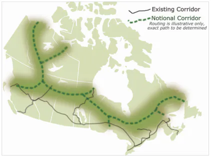
As a general definition, "a right-of-way is a specific route that people, animals, vehicles, watercraft, or utility lines travel, or the legal status that gives them the right to do so" [29]. A corridor is "a long narrow strip of land for which the highest and best use is to provide an economic or social benefit by connecting the end points, and sometimes serving intermediate points along the way", where "narrow" means wide enough to perform land's connecting function [30]. From a public policy standpoint, rights-of-way represent critical infrastructure corridors.
The definition of the CNC Right-of-Way was proposed as follows [9, 10]:
"What is the Northern Corridor right-of-way? The Northern Corridor concept is about establishing a new multi-modal (road, rail, pipeline, electrical transmission and communication) transportation right-of-way through Canada's north and near north. Northern Corridor would prepare the way for privately funded and economically driven projects to, for example, transport a full range of export commodities efficiently to port facilities on all three coasts while also improving economic development and living conditions in remote areas. This infrastructure would improve access for Canadian goods to alternative markets, assist with trade diversification, enhance regional development and interregional trade opportunities in Canada, support northern and Indigenous economic and social development goals along with Arctic sovereignty objectives, mitigate environmental risks through monitoring and surveillance within a contained footprint and reduce the emissions intensity of transportation in Canada's north and near-north."
Within the North and the Arctic, the Northern Corridor and the Economic and Security Corridors concepts present an economic planning matrix with an "east-west" oriented inter-provincial corridor core (a "trunk") and "north-south" oriented province-to-territory corridors ("branches").
2.2.3 Critical Infrastructure Triad
To plan Canada's Economic and Security Corridors development and operations in the sub-Arctic and Arctic, related critical infrastructure deployment efforts have to be coordinated and leveraged. This critical infrastructure coordination today requires transportation (e.g., highways, railways, seaports, airports), energy (e.g., oil and natural gas pipelines, electricity transmission lines) and communications/ICT (e.g., fiber-optic cables, large-scale telecommunication networks such as Wide Area Networks) to be co-located and co-deployed at the same time.
While each of these infrastructure types is practical and successfully used over years, there are three linear infrastructures in the North and the Arctic that are of absolute importance in an electrified Canadian economy. This critical infrastructure triad includes transportation highways, electricity transmission lines and communication lines. All these infrastructures are closely and positively interdependent, and there is growing understanding of the benefits of co-location/co-deployment of these infrastructures when deploying the Economic and Security Corridors. Deployment of these infrastructures also anticipates their ability to manage environmental impacts, support biodiversity, and provide ecosystem services.
2.2.4 Co-Location/Co-Deployment
Critical Infrastructure Leadership
Global experience and thinking related to co-location/co-deployment of the transportation-power-communications triad has been historically related to densely populated areas in the world. While the "infrastructure triad" term is generic, geopolitically the Northern and Central Asian efforts have been mostly focused on communications infrastructure (e.g., Fibre Optic Communication) co-location with transportation (see the Asia Pacific Information Superhighway initiative [31, 32, 33, 34, 35]) while the U.S. efforts today are focused on co-locating transportation with power transmission lines [36, 37].
Canada's current efforts in the North and the Arctic are different as they cover large and sparsely-populated areas with industrial growth (e.g., critical minerals mining), national security (e.g., defence) and international trade (e.g., access to the Arctic ports), and focus on significant upgrade of the quality of life of local communities. As such, these efforts today require aligning transportation highways deployment with access to high-quality power supply and to high-quality communications service using top-notch technology in power transmission and communications.
RoW Benefits
The benefits of critical infrastructure co-location/co-deployment in terms of cost, operation, and maintenance have been deeply explored and well documented in some parts of the world (e.g., [32, 33, 34, 35]).
There is growing understanding globally that co-location/co-deployment of critical linear infrastructure (such as highways, high voltage transmission lines, etc.) is economic time-wise, financially, and environmentally if the infrastructures' Rights-of-Way (RoW) are aligned.
Examples of RoW benefit factors for co-deployment of communication infrastructure with energy and transportation focused on the ground-type and aerial-type Fibre Optic Communication (FOC) solutions include [35]:
- Land acquisition: Land within RoW can be used free of charge
- Utility relocation: Few to no utilities in the RoW, no extra costs for deployment projects
- Property and utilization: RoW provides clear demarcation of land boundaries and prevents encroachment
- Financial performance: By providing primary infrastructure for FOC deployment the owners of transport infrastructure share the capital costs and improve the economy of deployment projects
- Operation and maintenance: Heavy duty concrete conduits provide maintenance and enable virtually unlimited space for expansion
- Safety and security of FOC lines: Risk of damage minimized as RoW is secured against uncontrolled works and closed for farming
- Resource sharing: Owners of transport infrastructure can provide equal access to ICT infrastructure to all interested telecom operators ensuring transparency and fair competition
- Time Performance: Putting FOC inside existing underground infrastructure can be completed very quickly at almost no cost compared with "full-cycle" separate deployment
As an example in [34], significant cost savings were derived from eliminating overlapping civil works: excavation, backfilling and reinstatement were the services with the greatest cost saving, as the earthwork was the largest cost component of duct deployment.
In all explored cases, co-deployment was synergetic for socio-economic co-benefits & cost savings.
Challenges and Actions
An example of reviewing policy, technical, and economic implications of co-locating transmission lines along existing transportation corridors in the U.S. to address expanded electric transmission capacity across the country as of 2025 is presented in [36]. While there is deep understanding that "co-locating transmission lines within existing transportation corridors could speed transmission project timelines, avoid opposition, and even enable otherwise impossible projects", the policymakers, regulators, utilities, and other stakeholders involved were asked to overcome the following key challenges [37]:
- Siloed planning that prevents coordination and cost-sharing,
- Slow and fragmented permitting processes.
Suggested stakeholder actions in the U.S. were ranked in descending order of priority as follows [36]:
- Collaborative planning and data exchange for siting and design; consider corridors and standard RoW valuation
- Standardization of process, requirements, and procedures for accommodations, with MOUs
- Joint task force/consortium at state levels for regular meetings and exchanges
- Educational resources/guide to understand each others' procedures and requirements
- Liaison/coordinator across groups, perhaps dual funded
- Alignment and process timelines and deliverables
- Develop non-discretionary criteria for siting and transmission alternative selections
- Transmission provided resource/fees to facilitate the Departments of Transportation (DOT) accommodations
- Consider transmission as a transportation system
- Establish a state level agency with the authority for DOT and transmission siting priorities
Based on existing experience and vision in North America and globally, the following actions were recommended for critical infrastructure planning and co-deployment [37]:
- Remove provincial regulatory barriers to co-location
- Align planning cycles of utilities, local and provincial government departments
- Align utilization of GIS mapping and overlays of local and provincial ROW assets (such as ESRI's right-of-way tool)
- Speed up permitting through federal and provincial environmental review processes
- Reduce environmental impact by eliminating the need for additional land disturbance
According to [37], opportunities for co-location may be considered to leverage the infrastructure ROWs as assets to generate significant long-term revenue streams through shared infrastructure build-out and maintenance.
These recommendations may be considered for Canada's Multimodal Corridor ROW efforts in the North and the Arctic.
2.2.5 Interdependencies
Current operations of critical infrastructure have brought drastic changes in its functionality and related interdependencies. This is most clearly seen in power generation (e.g., distributed energy sources (DER)) and transmission (e.g., HVDC multilevel converters) infrastructure, and in communications infrastructure (wireline such as fiber optic, and wireless such as wide area networks).
While infrastructure interdependence affects all critical infrastructure sectors, it is most dynamically experienced by power and communications sectors [38]. With bidirectional power flows between asynchronous generators and controllable loads supported by digital technology, grid communications requirements to support this more complex and information-rich architecture have increased. "The current and evolving environment requires a high-speed, bidirectional pathway for digital, packetized communications supporting power system monitoring and control functions, includes energy management, substation alarms, video monitoring, distribution automation, protection, and fault recording for both on- and off-network installations." [38].
2.2.6 Technological Advancements
Power Electronics in Transmission
The remote communities and industrial applications such as mining operations as well as national security operations supported by the multimodal Northern Corridor require power to be transmitted over long distances to meet electricity demand. A part of this demand may be characterized by large and often highly variable loads. This demand can be addressed by renewable generation resources that may be located remotely, some of them such as wind and solar also being variable. Long-distance transmission combined with large variable consumption and generation presents a major reliability and resilience challenge and a technological opportunity that can be successfully and effectively resolved by power electronics solutions.
One proposed power electronics solution in the Northern Corridor deployment is related to proposed long-distance HVDC power transmission as HVDC lines are commonly used because of their lower cost: they require fewer conductors and incur less power loss than equivalent AC lines [41, 42].
A key part of any HVDC transmission is power conversion. Power electronics devices — converters — rectify power from HVAC to HVDC and then invert it back from HVDC to HVAC. Converters also stabilize power grids against disturbances/rapid changes in voltage or frequency, and ensure cascading failures/disconnections and a widespread blackout do not happen in large parts of the electricity system.
Sometimes to ensure reliability and resilience of neighbouring grids only converter stations (aka "back-to-back" stations) are used in HVDC transmission for provincial interties and/or international connections. As an example, these converters synchronize connected power systems such as Quebec, Eastern and Western Interconnections in North America [39].
Specifically, most advanced HVDC voltage source converters (VSCs) use fully controllable semiconductor devices to synthesize AC voltages with adjustable magnitude and phase. This allows VSCs to independently control active and reactive power at the point of connection to the AC grid while balancing their total (aka "apparent power" - the total amount of power flowing in an AC grid [39, 40] — see Figure 23 below), and to provide voltage support and control, and fast frequency response enhancing grid stability.
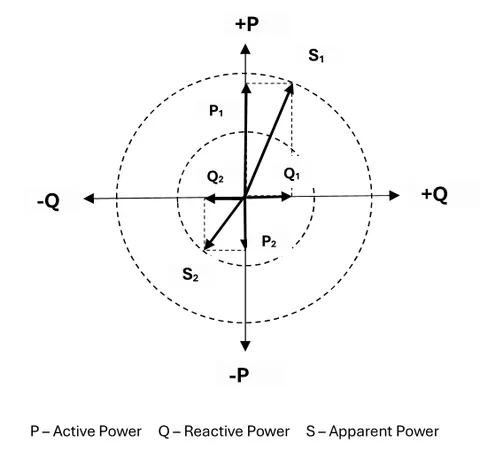
As an example, voltage at the point of connection to the transmission grid is governed by the local balance of reactive power [39, 40]. When reactive power supply is adequate, voltages remain stable and close to nominal values. If there is a deficit of reactive power, voltage declines; if there is an excess, voltage increases can lead to overvoltage conditions.
Meeting the needs of active and reactive power at electricity demand hubs under stressed electricity system conditions requires local voltage support; e.g., under high transfer conditions voltage can deteriorate rapidly without sufficient local compensation resources available.
Other power electronics solutions in transmission grids on the VSC semiconductor technology present battery energy storage systems (BESS) and static synchronous compensators (STATCOM) [40].
BESS offer both active and reactive power injection and absorption. While simultaneously offering inertial and frequency support, it also enables voltage regulation. By dynamically supplying active power, BESS can help stabilize frequency deviations and emulate inertia in the grid.
STATCOMs offer only reactive power injection and absorption. At the point of its connection to the grid a STATCOM can either supply reactive power to increase the grid voltage or absorb reactive power to reduce the voltage. Fast response time enables STATCOMs to control/stabilize voltage fluctuations caused by load changes, intermittent renewable generation, or short circuits.
Demonstrated achievements of power electronics in power transmission allow for highly recommending them as a critical infrastructure solution component in the Northern Corridor.
IT/OT Convergence in Communications
Changes in and convergence of Information and Operational technologies in power industry can be used to successfully leverage critical infrastructure co-deployment and operations in the Northern multimodal corridor.
Because of long distances between the key transmission hubs/substations in the corridor, an approach to leverage this convergence is presented by an effective combination of wireline and wireless technologies and applications. This includes ultra-broadband fiber optic connections between these substations providing a "backbone" for the corridor digital communications infrastructure, and 5G (5th generation) LTE (Long-Term Evolution) wireless network with new radio (NR) technologies for the substations, bringing flexibility of operations to today's technological level.
Deploying a common LTE network shared by the substations (both for their teleprotection and control) and by the Wide Area Network (serving the surrounding transportation infrastructure, neighbouring communities and industrial sites) may be seen today as a part of a wireless network evolution strategy [43, 44, 45, 46]. This ensures low latency and high performance of the communications infrastructure and allows for enhanced control and transparency of the interdependent critical infrastructures. The inherent security built into LTE/5G infrastructure and devices creates enhanced reliability and cybersecurity, making wireless networks in substations and in neighbouring communities a viable and cost-effective multipurpose solution.
With the vision, experiences and technological advancements of the critical infrastructure triad in the multimodal corridors, we will look attentively at opportunities leveraging the multimodal corridors in the North and the Arctic to consider a national-scale transmission approach — the Northern Supergrid.
3. Materials and Methods
3.1 Infrastructure Mega-Loop Principle
To leverage the Canadian Northern Corridor/Economic and Security Corridors planning matrix concept and applications, an inter-provincial infrastructure mega-loop principle was proposed.
3.1.1 Features and Foundations
The Mega-loop principle is related to the following geopolitical features of Canada:
- Ten provinces spanning linearly coast-to-coast
- Eight of ten provinces bordering with the U.S. in the south of the country
- Seven of ten provinces bordering with Canada's territories in the sub-Arctic region (five of them: BC, AB, SK, MB and NL at 60°N latitude, ON with its northernmost point at 56.8°N, and Quebec with its northernmost point at 62.6°N)
- Major critical minerals and clean energy/electricity resources located in the areas along the provinces/territories border.
- Inter-provincial trade corridors historically located in the south of the country
- Intra-provincial resource corridors historically oriented north-to-south of the country.
The principle reflects Canada's critical infrastructure [162] planning matrix shaped by the "east-west" oriented Canadian Northern Corridor and the "north-south" oriented Economic and Security corridors in the country.
The principle also reflects the Federal Government's commitment to "developing Canada's trade and transportation corridors that can make the greatest contribution to interprovincial and international trade, prioritizing areas where growth is held back by infrastructure capacity constraints" [163, 164].
The mega-loop principle is based on the following critical infrastructure foundations:
- Inter-provincial transportation corridors allowing for transportation highways to reach destinations coast-to-coast (e.g., the Trans-Canada Highway [165]);
- Intra-provincial transportation ring roads/beltways around major urban centres (e.g., full beltways for Calgary and Edmonton, AB or Winnipeg, MB or metropolitan beltways formed by a ring of connecting highways in Toronto, ON or Montreal and Quebec City, QC);
- Intra-provincial transmission loops allowing for high voltage power transmission (such as 500 kV in British Columbia or 735 kV in Quebec [166]) around the major load demand centres.
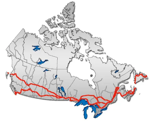
b) Trans-Canada Highway along Canada-U.S. border [165]
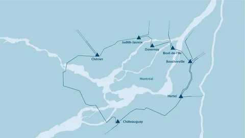
a) HVAC Transmission Grid Loop around Montreal, QC [166]
Figure 24: Critical Infrastructure Mega-Loop foundations.
These foundations allow for upgrading critical infrastructure deployment and operations interprovincially using a coast-to-coast infrastructure mega-loop supporting developments in the North and the Arctic.
3.1.2 Definitions and Structure
This principle is based on the following definitions:
- Corridor: Existing or planned critical infrastructure within its established Right-of-Way for its components: Trunks and Branches
- Trunk: Existing or planned critical infrastructure oriented "east-west" along a border (international or provincial-territorial) within its established Right-of-Way.
- Branch: Existing or planned intra-provincial, interprovincial, provincial-territorial, or international critical infrastructure oriented "north-south" within its established Right-of-Way, starting at/connected to a Trunk.
- Terminal: Critical infrastructure transfer and processing point of a Corridor.
- Link: Existing or planned intra-provincial critical infrastructure within its established Right-of-Way connecting the close Terminals of two Corridors.
The Mega-Loop Structure includes:
Southern and Northern Corridors:
- The Southern corridor is located close to the Canada-U.S. border;
- The Northern corridor is located close to the provincial-territorial border.
- Each Corridor has an east-west oriented trunk, and southward and northward branches.
Trunks:
- The Northern Trunk has two terminals: The Western terminal in B.C. (its northeastern area) and the Eastern Terminal in NL (the Labrador area).
- The Southern Trunk also has two terminals: The Western terminal in B.C. (the southeastern area) and the Eastern Terminal in NL (the Newfoundland area).
Terminals and Links:
- The Western terminals of the trunks are connected by the Western Link.
- The Eastern Terminals of the trunks are connected by the Eastern Link.
Branches:
- The southward branches of the Southern Corridor are connected to the existing international infrastructure in the U.S.
- The northward branches of the Southern Corridor and the southward branches of the Northern Corridor are or plan to be connected to the existing intra-provincial and interprovincial infrastructure. The northward branches of the Southern Corridor and the southward branches of the Northern Corridor may create full links connecting the Southern and Northern trunks.
- The northward branches of the Northern Corridor are planned to be connected to the infrastructure developed in the Territories.
According to the above structure and definitions, the proposed critical infrastructure mega-loop has two major "trunks" (the Northern trunk close to the provincial-territorial border and the Southern trunk close to the Canada-U.S. border) connecting the Atlantic and the Pacific coasts. The terminals of the Northern and Southern trunks are connected by critical infrastructure links (the Western Link and the Eastern Link) in the provinces of British Columbia and Newfoundland and Labrador (see Figure 25):
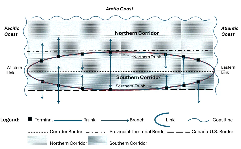
Figure 25 also shows the northward and southward branches of the Trunks.
3.1.3 Applications
Applying the above mega-loop terminology to Transportation Highways Infrastructure, we have the following mega-loop components:
- Southern and Northern Transportation Corridors
- Southern and Northern Transportation Trunks with related Southward and Northward Transportation branches
- Western and Eastern Transportation Terminals and Links
Applying the above mega-loop terminology now to Power Transmission Infrastructure, we have the following mega-loop components:
- Southern and Northern Supergrids
- Southern and Northern Supergrid Trunks with related Southward and Northward Supergrid branches
- Western and Eastern Supergrid Terminals and Links
Using the above critical infrastructure mega-loop principle and terminology, we apply it in the next section to transportation highways infrastructure — the key supporter of the Northern Grid planning and deployment in the North.
4. Trans-North Highway Challenge
The Transportation Highways infrastructure in the North (the Trans-North Highways) is seen as the core for the interprovincial multimodal corridor deployment. This critical infrastructure segment of the Canadian Northern Corridor is expected to leverage the current and planned achievements in the North and the Arctic to deploy the Northern Supergrid and its ties to the territorial grids in the country.
The built transportation infrastructure in the provincial North supporting the Northern Grid planning is summarized in Tables 3 and 4 and visualized in Figure 26.
Table 3 presents the components of the Northern Transportation Trunk — east-west oriented northern roads in each of six neighbouring provinces: Newfoundland and Labrador, Quebec, Ontario, Manitoba, Saskatchewan and Alberta that may be used for supporting the deployment of the Northern Supergrid coast-to-coast. The table includes intra-provincial or interprovincial parts of the roads, their provincial numbers, locations for the western and eastern terminals of the roads, and indicates the key towns the roads run by. The table also shows the segments of the Northern Trunk where no all-season or winter-only transportation infrastructure has been built, indicating the length of these segments in kilometers (roughly).
Table 3: Northern Transportation Trunk.
| Province | Road # | Western Terminal | Via Town | Eastern Terminal | Comments / Distance |
|---|---|---|---|---|---|
| QC/NL | NL 510/ QC 138 | Blanc Sablon, QC | L'Anse Au Clair, NL | ||
| NL | NL 510/500 | Labrador City, NL | L'Anse Au Clair, NL | ||
| QC/NL | QC 389 /NL 500 | Fermont, QC | Labrador City, NL | ||
| QC | Road N/A* | Brisay, QC | La Dinette, QC | Fermont, QC | 293 km |
| QC | Trans-Taiga Road | Radisson, QC | Brisay, QC | ||
| QC | Billy-Diamond Highway (former James Bay Road) | Fort George, QC | Radisson, QC | ||
| QC/ON | Ferry N/A* | Lake River, ON | Fort George, QC | 230 km | |
| ON | Road N/A* | Peawanuck, ON | Lake River, ON | 200 km | |
| MB/ON | Wapusk Trail (a winter road) | Gillam, MB | Shamattawa, MB /Fort Severn, ON | Peawanuck, ON | 613 km |
| SK/MB | Roads N/A* | Stony Rapids, SK | Gillam, MB | 733 km | |
| AB/SK | Roads N/A* | Garden Creek, AB | Chipewyan | Stony Rapids, SK | 469 km |
| AB | AB Road 58 | High Level, AB | Garden Creek, AB | ||
| BC/AB | AB 35/2/49 BC 97 | Fort St. John, BC | Berwyn/Rycroft, AB Dawson Creek, BC | High Level, AB |
*N/A: Not Available
Most of the transportation infrastructure segments (such as roads or ferries) not built are located between the provinces (such as the region of Côte-Nord, QC connecting to the western Labrador, or the northern James Bay between Ontario and Quebec) with historically limited population and operations. These transportation infrastructure segments may be considered for long-term planning with their RoW for the Northern Supergrid operations.
In terms of comparison of infrastructure segments distances, the segments not yet built present about 50% of the Northern Trunk distance, with the segments gap in the East of Canada about 20% and in the West — about 30%.
A draft map of the Northern Transportation Trunk is shown in Google Maps format on Figure 26; it also indicates the distances between the neighbouring hubs/terminals on the Trunk.
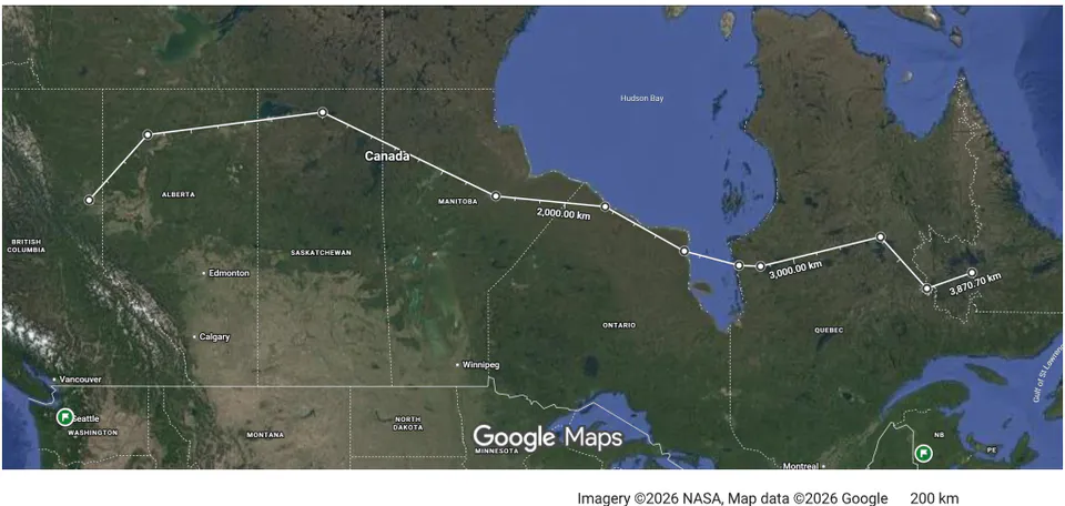
The existing transportation infrastructure oriented south-north (the "branches") for the provinces of Quebec, Ontario, Manitoba, Saskatchewan and Alberta is shown in Table 4 below. This table highlights the roads connecting the Southern Transportation Trunk and the Northern Transportation Trunk that may be available for supporting the Northern Supergrid deployment operations.
Table 4: Transportation infrastructure "branches" connecting the Southern and the Northern Transportation Trunks.
| Province | Road # | South Terminal | Via terminal / Road # | North Terminal |
|---|---|---|---|---|
| AB | AB 35/AB 2 connecting to Trans-Canada Highway (AB 1) | Calgary/Edmonton, AB | High Level, AB | |
| AB/SK/MB | AB 35/AB 2/AB16 connecting to Trans-Canada Highway (AB 1) | Portage La Prairie, MB | Saskatoon, SK | High Level, AB |
| SK | SK 964/905/102/2 connecting to Trans-Canada Highway (SK 1) | Lynbook Heights, SK | La Ringe, SK | Stony Rapids, SK |
| MB | MB 280/6/101 connecting to Trans-Canada Highway (MB 1) | Winnipeg, MB | Thomson, MB | Gillam, MB |
| ON | ON 599 connecting to Trans-Canada Highway (ON 17) | Ignace, ON | Pickle Lake, ON | North Caribou Lake, ON |
| ON | Winter roads | North Caribou Lake, ON | Bearskin Lake and Sachigo Lake | |
| ON | Winter road | Pickle Lake | Big Trout Lake | |
| ON | ON 106 connecting to Trans-Canada Highway (ON 17) | Vermilion Bay, ON | Red Lake, ON | Pikangikum, ON |
| ON | Winter Roads | Pikangikum, ON | North Spirit Lake, ON | Deer Lake Sandy Lake Keewaywin |
| ON | ON 634 connecting to Trans-Canada Highway (ON 11) | Smooth Rock Falls, ON | Fraserdale, ON | Smoky Falls, ON |
| QC | QC 389 (Trans-Quebec Hwy) | Baie-Comeau | Fermont | |
| QC | QC 138 West | Quebec City | Baie-Comeau | |
| QC | Billy-Diamond Highway (former James Bay Road) | Matagami | Radisson | |
| QC | QC 109 | Rivière-Héva (on Route 117, the Trans Canada Highway Route) | Matagami |
The Table 4 data show that the north-south oriented branches infrastructure (all-season paved roads) is available and has been used for many years to support the operations on the North Transportation Trunk in Quebec, Manitoba, Saskatchewan and Alberta.
The level of deployment in the north of Ontario is different. The all-season paved roads can reach operations at about 52°N (e.g., close to Pickle Lake), can reach some of First Nations communities at about 54°N (e.g., Big Trout Lake or Sachigo Lake) by winter roads only, and cannot reach the Northern Trunk at Peawanuck (55°N) and Fort Severn (55°N) — see Figure 27 below.
The transportation infrastructure connecting the western and the eastern terminals of the Southern and the Northern Trunks is shown in Tables 5 and 6 below.
Table 5: The Western Link connecting the Southern and the Northern Transportation Trunks in British Columbia.
| Province | Road # | Southern Trunk Terminal | Via Town | Northern Trunk Terminal |
|---|---|---|---|---|
| BC | BC 97 (Cariboo Highway) connecting to Trans-Canada Highway (BC 1) | Cache Creek, BC | Quesnel and Prince George, BC | Fort St. John, BC |
Table 6: The Eastern Link connecting the Southern and the Northern Transportation Trunks in Newfoundland and Labrador.
| Province | Road #/Ferry | Southern Trunk Terminal | Via Town | Northern Trunk Terminal |
|---|---|---|---|---|
| QC/NL | Ferry | St. Barbe, NL | Blanc Sablon, QC | |
| NL | NL 1/439 West | Channel-Port aux Basques, NL | St. Barbe, NL | |
| NL | NL 1/439 East | St. John's, NL | St. Barbe, NL | |
| NL/NS | Ferry East | Sydney, NS | St. John's, NL | |
| NL/NS | Ferry West | Sydney, NS | Channel-Port aux Basques, NL |
With the Western and Eastern Transportation Links connecting the Southern Trunk and Northern Trunk in mind, a draft map of the interprovincial Transportation Infrastructure Loop is shown in Google Maps format on Figure 28 below:
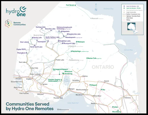
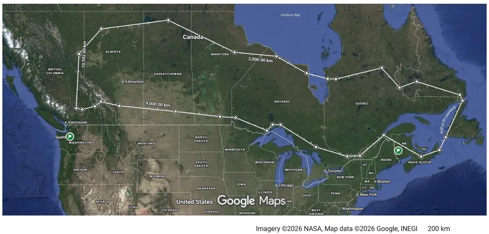
The Interprovincial Transportation Infrastructure Mega-Loop map shown on Figure 28 presents an idea of transportation and power transmission opportunities in the country in long-term.
A sketch of the Interprovincial Transportation Infrastructure Mega-Loop as of today shows the gaps in the loop and opportunities to address them. An example of a such a gap/opportunity is a potential multimodal RoW (290 km) in Quebec to connect Trans-Labrador Hwy (Road 500) and Road 389 at Mont-Wright, QC with Trans-Taiga Hwy at Brisay, QC.
The Northern Transportation Trunk is also seen as a foundation and a leverage for strengthening the operations of the Canadian territories and the sub-Arctic and Arctic areas, as well as for becoming a critical infrastructure support for economic and security operations of the country (see Figure 29 and Figure 30 below):
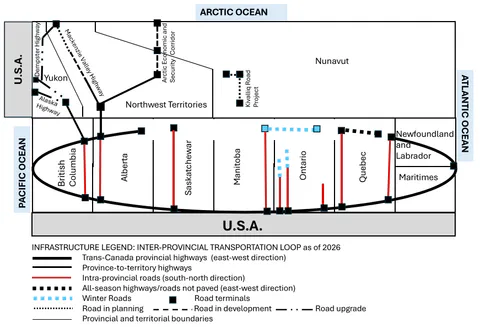
Figure 29 indicates the focus of the Federal Government in 2026 in transportation infrastructure in Northwest Territories targeting the Mackenzie Valley Highway, and the Northwest Territories and Nunavut infrastructure targeting the Grays Bay Road and Port and the Arctic Economic and Security Corridor [1].
An advanced approach presented in this paper (see Figure 30 below) extends this focus and related investments planning by strengthening the Interprovincial Transportation Infrastructure Mega-Loop by 2050:
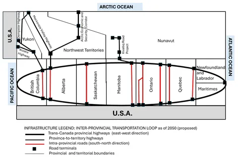
This approach addresses the needs to:
- Establish all-season non-paved transportation infrastructure in the north-eastern Quebec between the towns of Fermont, QC on the border with Labrador and Brisay, Caniapiscau area, QC (about 290 km).
- Establish a ferry service from the western terminal of the James Bay Route close to Fort George, QC on the eastern coast of James Bay to a location close to the mouth of Lake River, ON on the western coast of James Bay (about 230 km).
- Extend the Wapusk Trail eastward from Peawanuck, ON to the selected James Bay ferry terminal close to the Lake River's mouth (about 200 km), and transform the extended Wapusk Trail between Gillam, MB and Lake River, ON into an all-season non-paved road (overall about 820 km).
- Establish an all-season non-paved road between Gillam, MB and Stony Rapids, SK (about 730 km).
- Establish an all-season non-paved road between Stony Rapids, SK and Garden Creek, AB (about 470 km).
- Upgrade the all-season paved road Garden Creek, AB to High Level, AB.
This very significant effort would result in deploying critical infrastructure for transportation operations coast to coast, and would allow for supporting the deployment of necessary transmission infrastructure components of the Northern Grid.
Based on the current, planned and proposed solutions for the core transportation infrastructure, and on the opportunities to use these solutions to support the Northern Supergrid deployment, we will now look attentively at the Northern Supergrid — a proposed key transmission part of the National Energy Corridor - as we see it today and in possible sustainable futures applying the Mega-Loop principle discussed earlier.
5. Northern Supergrid: How Should It Look Like?
5.1 Inter-Provincial Transmission Realities
5.1.1 Canada's Transmission Islands
An excerpt from a report prepared for Electricity Canada [170] defines Canadian Electricity System today as follows:
"The Canadian electricity sector is unique in generation mix, geography, and regulatory structure when compared with other North American jurisdictions. Regulation of the sector takes place at the provincial level with limited regulation of transmission lines that cross provincial boundaries. Except for Alberta, vertically integrated utilities develop the provincial transmission grid and generation resource mix to benefit the province and ratepayers as much as possible. In Alberta, transmission and distribution functions are provided by unbundled utilities and generation is provided in a competitive, energy-only market.
Given the provincial boundaries in Canada, the abundance of vertically integrated utilities, and the nature of regulation, transmission in provinces has largely been focused on North to South corridors connecting resources to load centers within each province, and from provincial load centers to US load centers on the other side of the border. Some connectivity exists between provinces; however, these connections are generally small relative to the size of the markets being connected. In addition, most extra-provincial interconnections have focused on international trade with the US as opposed to a trans-Canadian network. This is again a function of Canadian geography in that Canadian load centers are often much closer to US load centers on the other side of the international border than they are to other Canadian load centers in neighboring provinces.
Most Canadian provinces operate nearly as islands, with limited connectivity amongst Western Provinces (BC, Alberta, Saskatchewan, and Manitoba) and similarly limited connectivity between the Eastern Provinces (Ontario, Quebec, and Atlantic Canada).
Canada's generation mix is also unique with roughly 60% of electricity generation coming from hydroelectric sources. B.C., Manitoba, Quebec, Newfoundland and Labrador, and Yukon all generate over 80% of their electricity from hydropower, while Alberta, Saskatchewan, and Nova Scotia primarily generate their electricity from fossil fuels."
Jurisdictional electricity market structures in Canada are well defined in [171]:
- Deregulated electricity market/market-led systems: Electricity markets where generation is supplied through competition among generators, with prices often set in wholesale markets. Transmission and distribution networks typically remain regulated.
- Co-ordinated electricity markets: Electricity systems where government, system operators, or utilities help centrally plan and procure new supply. Wholesale competition may still exist, but long-term investment is meaningfully shaped by such central planning and procurement.
- Regulated electricity markets: Electricity systems where monopoly utilities are responsible for serving customers, and regulators approve the costs recovered through customer rates. These systems may still use competitive procurement for new generation or services, but customer rates and utility returns remain regulated.
Within the national electricity system, Alberta uses a deregulated electricity market/market-led system; Ontario uses a co-ordinated electricity market; all other provinces/territories use regulated electricity markets operated by utilities.
More detailed information about the jurisdictional electricity systems may be found in [39].
Currently, Canada's territorial transmission grids in the Northwest Territories and the Yukon are not connected to provincial grids, and Nunavut does not have a shared transmission grid (each of Nunavut's communities operates its own independent, stand-alone local power generation and distribution system).
While in late June 2026 the Federal Government already announced its financial and regulatory support of the British Columbia–Yukon Grid Connect, an 800-km, 200-kV HVDC transmission line [174], no approval so far has been announced for the proposed Kivalliq Hydro-Fibre Link project addressing the critical infrastructure needed for sustainable economic growth, energy security, and digital connectivity in Nunavut [110]. Also, no projects have been proposed to link the Taltson Hydro Expansion Project, connecting the Taltson and Snare grids and already referred to the Major Projects Office [1], with the transmission grid in Alberta to enable much needed industrial development in the sub-Arctic and Arctic.
The non-interconnected and isolated state of the territorial grids, the lack of connections between the provincial and territorial grids, and fragmented provincial grids highlight the need for a national-scale transmission infrastructure approach — the Northern Supergrid.
5.1.2 HVDC: The Key to Transmission Modernization
To link the provinces and territories together, High Voltage Direct Current (HVDC) transmission technology presents the optimal and most practical technological solution. Compared to High Voltage Alternating Current (HVAC), HVDC lines have considerably lower transmission losses over long distances and require smaller rights-of-way footprints. Furthermore, modern Voltage Source Converter (VSC) technology allows connecting asynchronous grids, provides black-start capability, and enables independent control of active and reactive power.
5.1.3 Southern Supergrid Already Taking Shape
In Southern Canada, interconnections and transmission expansions along the Canada-U.S. border and between provinces have been actively planned and developed. This evolving southern network effectively forms a Southern Supergrid. To achieve true national grid resilience and connect the northern territories, this southern backbone must be paired with an advanced Northern Supergrid.
5.2 Northern Supergrid in a Mega-Loop
Applying the Infrastructure Mega-Loop Principle, the Northern Supergrid acts as the northern counterpart to the Southern Supergrid. Together, they form an interprovincial transmission loop connecting Canada's Atlantic, Pacific, and Arctic energy resources and demand centres.
5.3 Northern Supergrid as the Critical Infrastructure Leader
5.3.1 Northern Supergrid Trunk
Based on this vision, a review has been completed to select existing power infrastructure assets that are aligned with/connected to the existing transportation infrastructure and that can be used as the core provincial hubs/terminals of the Northern Supergrid Trunk (see Table 7), and to define potential locations for developing these core power infrastructure assets on the Northern Trunk in the provinces that do not have them available.
Another important objective of this review was to select the efficient locations of power assets on the Northern Transportation Trunk so that they connect to the Northern Supergrid "branches" — the power lines leading to the transmission grids of the Territories.
The results of this review showing the core power infrastructure assets of the Northern Supergrid Trunk within the power transmission loop as of 2026 are presented in Figure 31.
Table 7: Core power infrastructure assets of the Northern Supergrid Trunk.
| Province | Power Infrastructure | Latitude/Longitude | Location/Close to | Capacity, MW | Switchyard Voltage, kV |
|---|---|---|---|---|---|
| NL | Churchill Falls Generation Station | 53.53N 63.97W | Churchill Falls, NL | 5,428 MW | 315/735 kV AC |
| NL | Wabush Substation | 52.90N 66.86W | Wabush, NL | 1,500 MW proposed | 230 kV AC / 750 kV AC proposed |
| QC | La Grande-4 generating station, James Bay Project | 53.89N 73.46W | La Grande-Quatre, QC | 2,779 MW | 315/735 kV AC |
| QC | La Grande-3 generating station, James Bay Project | 53.73N 75.97W | Sakami, QC | 2,418 MW | 735 kV AC |
| QC | La Grande-2a generating station | 53.78N 77.55W | Radisson, QC | 2,106 MW | 315/735 kV (via Robert-Bourassa switchyard) |
| QC | Robert-Bourassa generating station (La Grande-2), James Bay Project | 53.80N 77.44W | Radisson, QC | 5,616 MW | 315/735 kV AC |
| QC | La Grande-1 generating station, James Bay Project | 53.73N 78.57W | Between Fort George, QC and Radisson, QC | 1,436 MW | 315/735 kV AC (via Robert-Bourassa switchyard) |
| QC | Radisson HVDC Converter Station | 53.73N 77.73W | Radisson, QC | 2,000 MW | 315 kV AC/450-kV DC |
| ON | N/A | N/A | N/A | N/A | N/A |
| MB | Keewatinohk Converter Station | 56.85N 93.71W | Gillam, MB | 2,000 MW | 500 kV |
| SK | N/A | N/A | N/A | N/A | N/A |
| AB | N/A | N/A | N/A | N/A | N/A |
| BC | South Bank Substation | 56.18N 120.91W | Fort St. John, BC | 150 MVA/ 1,100 MW (part of Site C Project) | 500/230 kV AC |
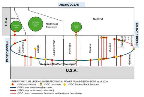
The results of this review indicate that the existing core power assets are available in Newfoundland and Labrador on the Labrador Highway (Churchill Falls Generation Station, NL), in Quebec on the Trans-Taiga Highway (the La Grande complex, QC), in Manitoba at the western terminal of the Wapusk Trail — the winter road from Gillam, MB to Fort Severn, ON (close to the Radisson/Bipole I, Henday/Bipole II and Keewatinohk/Bipole III converter stations in Manitoba), and in British Columbia as a part of the transportation network including Fort St. John, BC (South Bank Substation as a part of the 500 kV BC Hydro transmission system). These core assets are also well connected to the southern part of Canada via the "south-north" transportation infrastructure "branches" (see Table 4).
The Short-Term phase (2026 to 2035) includes:
- AB-NT HVDC transmission deployment
- BC-YK HVDC transmission deployment
- MB-NU HVDC transmission deployment
- BC-AB HVAC transmission deployment
- NL HVAC transmission deployment
The Short-Term phase of the Northern Trunk deployment anticipates the following advancements:
- It will enable direct transmission connections with the Yukon, the Northwest Territories, and Nunavut.
- It will strengthen electricity support for industrial operations in Saskatchewan's North.
- It will support hydro generation resources of La Grande River in the north of Quebec to be effectively used across the Southern Supergrid.
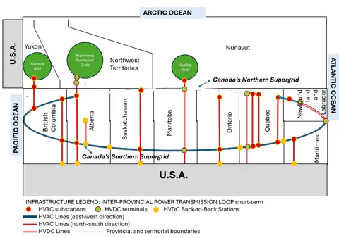
The Mid-Term phase (2036 to 2045) includes:
- MB-ON HVDC transmission deployment
- AB-SK HVDC transmission deployment
- SK-MB HVDC transmission deployment
The Mid-Term phase of the Northern Trunk deployment anticipates the following advancements — see Figure 33:
- It will strengthen inter-provincial trade between the northern Manitoba and Ontario through an HVDC line between Gillam, MB and Fort Severn, ON covering all power needs in the north of the provinces and supporting the Kivalliq region of Nunavut.
- It will strengthen inter-provincial trade between the northern Manitoba and Saskatchewan supporting the Athabasca region;
- It will strengthen the Western and Eastern Interconnections interties in North America via the AB-SK HVDC transmission deployment in the North.
The Pacific terminals of the Southern and Northern supergrids connected via BC Hydro's HVAC transmission system, and the Atlantic terminals of the Southern and Northern supergrids connected via the HVAC transmission line between the Churchill Falls and Muskrat Falls Generation Stations.
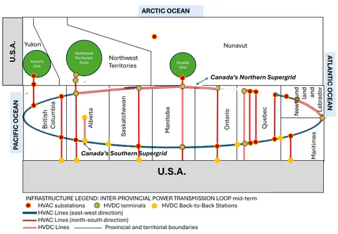
The Longer-Term phase (2046 to 2050+) includes:
- QC-NL HVDC transmission deployment
- ON-QC HVDC transmission deployment
The Longer-Term phase of the Northern Trunk deployment (see Figure 34) is focused on establishing stronger interlinks between the Eastern Interconnection and the Quebec Interconnection in North America. This will be done by connecting the Hydro Quebec transmission grid with the Ontario transmission grid and the Newfoundland and Labrador transmission grid at the latitudes close to 60 degrees North.
Overall, the Northern Supergrid when its longer-term phase has been completed will ensure the following advances:
- Extension in transportation infrastructure highlighted in section 4 (see Figure 30) that would result in all-season non-paved roads along the Northern Trunk connecting the towns of Fermont and Fort George in Quebec, and leading from the coast of James Bay via Fort Severn, ON and Gillam, MB to Stony Rapids, SK and further to High Level, AB.
- A major part of the Northern Supergrid trunk deployed as a multi-terminal, multi-vendor HVDC transmission system with six Voltage Source Converters (VSC) at the High Level (AB), Stony Rapids (SK), Gillam (MB), Fort Severn (ON), Fort George (QC) and Wabush (NL) Converter Stations.
- Intra-provincial HVAC transmission lines ("north-south" oriented branches) strongly connect the Southern and Northern supergrids in Quebec, Ontario, Saskatchewan and Alberta.
- Intra-provincial HVDC transmission lines (also operating as "north-south" oriented branches) strongly connect the Southern and Northern supergrids in Newfoundland and Labrador, Quebec, and Manitoba.
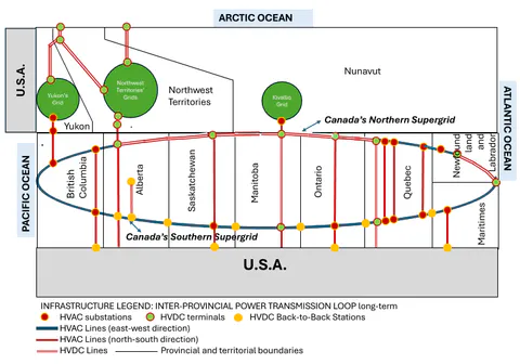
5.3.2 Northern Supergrid Branches
The Southward Branches of the Northern Supergrid connect the Northern Trunk to the Southern Supergrid and industrial demand hubs such as the Athabasca oil sands near the Saskatchewan border [168]:
The proposed southward branch starting with the Stony Rapids hub of the Northern Trunk will deploy an HVAC transmission line with substations in Patterson Lake, SK to support mining operations and in Fort McMurray, AB to support the oil industry operations with oil sands. It may also have a power line from the Patterson Lake substation to support mining operations in La Loche, SK.
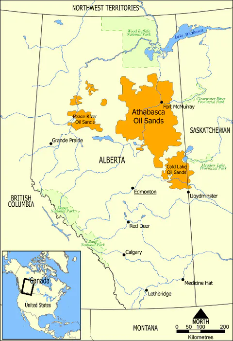
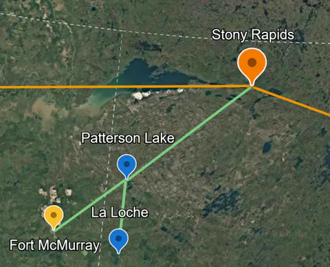
b) Transmission Branch from Stony Rapids Converter Station to Fort McMurray, AB
Figure 35: Southward transmission branch from Stony Rapids Converter Station to Fort McMurray, AB.
The Northward Branches of the Northern Supergrid also start from the major supergrid hubs on the Northern Trunk and support the power transmission hubs in the Canadian Territories. These branches allow for supporting power transmission and exchange between the provinces and the territories, leverage the existing or planned power infrastructure in the Yukon (e.g., the Yukon–British Columbia Grid Connect) and Nunavut (e.g., the Kivalliq Hydro-Fibre Link), and leverage the transportation infrastructure in the Northwest Territories reaching the Arctic Ocean via the Mackenzie Highway and the Arctic Corridor.
Based on the federal planning announced in November 2025 to unlock world-class resources in the Northwest Critical Conservation Corridor [56], and in March 2026 to defend, build, and transform the North through critical minerals development and clean power transmission [1], the Northward Branches considerations as of 2026 are seen as follows.
The Yukon Branch presents a strategic connection of the isolated electricity grid in the Yukon to BC Hydro transmission grid, Canada's inter-provincial electricity grid and the Western Interconnection in North America, proposed by British Columbia and the Yukon. In the Northern Supergrid concept this branch is defined by the expansion of the North Coast Transmission Line in BC into the Yukon (see the Yukon–British Columbia Grid Connect project [55]). It operates as a transmission radius from Williston substation on the BC Hydro 500 kV transmission loop via Skeena substation and Bob Quinn Lake substation to the Watson Lake substation in the Yukon (see Figure 36). After reaching the Watson Lake substation on the border of BC and the Yukon the transmission line moves further northward into the Yukon grid.
Currently the Whitehorse and Faro transmission development options are being considered for the Yukon branch deployment [55].
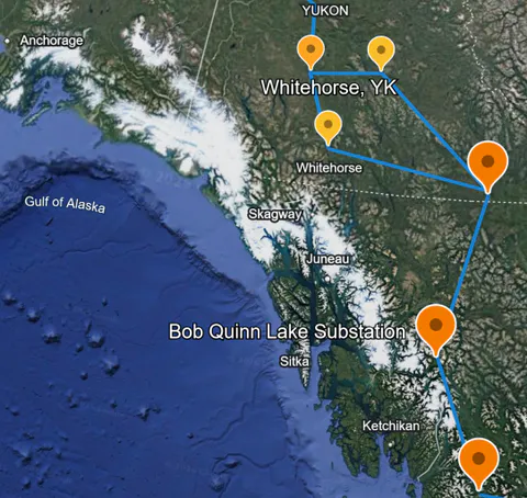
While the Yukon–British Columbia Grid Connect project is already agreed on, considerations in more advanced long-term planning may be given to extend the northward transmission branch along the major highways YK 2 (the Klondike Highway) and YK 5 (the Dempster Highway), crossing the Northwest Territories on their western border and reaching Inuvik, NT. This approach would allow for creating a strategic regional transmission loop between the Alaska, Klondike and Dempster highways connected to the Yukon branch and the Mackenzie Valley Highway connected to the Northwest Territories branch of the Northern Supergrid supporting the Northwest Critical Conservation Corridor in Canada (see Figure 37 below). It may also propose an intra-territorial transmission loop between Whitehorse, Carmacks and Faro, YK, addressing and supporting mining and clean energy operations in the area.
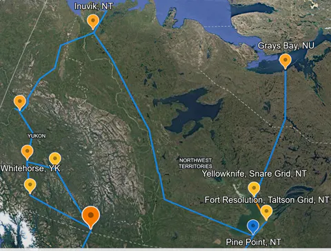
The Northwest Territory Branch (aka Pine Point northward branch) presents a strategic connection of the two transmission grids in this territory (the Taltson Grid on the south shore and the Snare Grid on the northern shore of the Great Slave Lake) with the transmission grid in Alberta managed by AESO. The proposed branch starts at the High Level converter station towards the Pine Point transmission hub in the Northwest Territory where it is connected to the Taltson Grid (see Figure 38 below). From there it is proposed to move via Fort Resolution to the HVDC terminal on the northern shore where it is connected with the Snare Grid by a subsea HVDC cable thus expanding green energy infrastructure in the Northwest Territories and providing clean power to Yellowknife (see the Taltson Hydroelectricity Expansion Project [79, 1, 80]). This will later allow for extending the Snare Grid using the Arctic Economic and Security Corridor transportation infrastructure deployment [85]. Coordination of the transportation and transmission infrastructure deployment in this corridor, coordinated with the transportation and transmission infrastructure deployment of the Grays Bay Road and Port in Nunavut [118] as multimodal, multi-purpose, multi-user assets will allow for strengthening Canada's Arctic sovereignty and defence, enhancing Canada's long-term presence and connectivity in the North, and opening new opportunities for northern communities and Canadian industry.
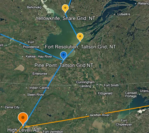
a) Integration of the Taltson and Snare Grids into the Northern Supergrid
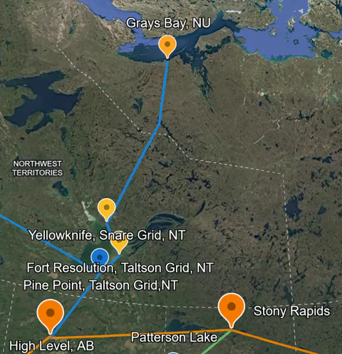
b) Arctic Corridor and Grays Bay Power Line proposition
Figure 38: The Northwest Territories transmission branch.
While the Taltson Hydroelectricity Expansion Project has been already approved by the federal government and is in its deployment stage, other northward branch opportunity connected to the proposed Pine Point transmission hub may be considered. Specifically, using the Mackenzie Valley Highway [88] as a multimodal, multi-purpose, multi-user asset will allow for following up with transmission infrastructure within its ROW connecting Yellowknife and Inuvik electricity-wise thus upgrading critical minerals exploration and supporting Canada's arctic sovereignty and security operations in the Inuvik Region. It may also consider collaboration with the Yukon in long-term planning of its transmission infrastructure along the Alaska, Klondike and Dempster highways to support the Northwest Critical Conservation Corridor (see Figure 37).
The Nunavut Branch (aka Kivalliq northward branch) presents a strategic connection of a proposed transmission grid in the Kivalliq region of Nunavut with the Manitoba transmission grid. This transmission branch connects the Manitoba converter station hub of the Northern Supergrid with Churchill, MB and the five western communities and two Agnico Eagle mines in the Kivalliq region of Nunavut (the Kivalliq Hydro-Fibre Link project [111, 112, 113, 114, 115, 116, 117]) supporting operations in Hudson Bay (see Figure 39). The project also includes fibre-optic connectivity, delivering high-speed internet service [114, 115].
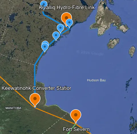
5.4 Exploratory Costs
The Northern Supergrid exploratory costs are presented below. The exploratory costs are based on the following cost assumptions:
- Coordination of "co-location/co-deployment" with Trans-North highway development/advancement allowing for maintaining the transmission deployment costs at standard cost levels.
- Inclusion of transmission project contingency and Allowance for Funds Used During Construction (AFUDC) at the high Exploratory Cost Estimate level: contingency at 30% and AFUDC at 7.5%. This will allow for considering project-specific environmental circumstances of the Northern Supergrid components (e.g., related increase in the cost of a new transmission line that traverses a forested area, wetland area, or mountainous terrain) within the planned project budget.
Table 8 below presents specific transmission line and converter costs in Canada based on the well-established international data [178, 179, 180, 39] at 1.4 USD/CAD currency exchange level.
The Northern Supergrid transmission line component parameters defining their costs are presented in Table 9.
Using the specific rates presented in Table 8 and the parameters of the Supergrid components in Table 9, the Northern Supergrid exploratory costs are calculated and presented in Table 10 below.
As indicated in the new National Electricity Strategy, the expected infrastructure expansion and modernization of Canada's provincial and territorial electricity systems from now to 2050 is forecast to cost over $1 trillion (see [172] and related references). Deploying the Northern Supergrid as a strategic long-term investment by 2050 within around 3% of the forecast National Electricity Strategy budget may be seen as an attractive proposition and a "cooperative federalism in action" opportunity from the public policy standpoint.
Table 8: Specific power transmission rates.
| Parameter | Value |
|---|---|
| HVDC Lines | |
| Supergrid Trunk Capacity, MW | 2000 |
| Supergrid Trunk Voltage, kV | |
| New bipole HVDC transmission line, thousand US$/mile | 3000 |
| New bipole HVDC transmission line, thousand CAD/km | 2610 |
| New bipole HVDC transmission line, thousand CAD/(km-MW) | 1.305 |
| HVAC Lines | |
| BC-AB Voltage, kV | 500 |
| NL Voltage, kV | 750 |
| New HVAC transmission line 500 kV, thousand US$/mile | 4600 |
| New HVAC transmission line 500 kV, thousand CAD/km | 4002 |
| New HVAC transmission line 750 kV, thousand US$/mile | 5800 |
| New HVAC transmission line 750 kV, thousand CAD/km | 5046 |
| Submarine Cables | |
| Submarine cable line 2000 MW, thousand USD/km | 26,068 |
| Submarine cable line 2000 MW, thousand CAD/km | 36,495 |
| Cost ratio, submarine vs overhead HVDC line | 14.0 |
| MTDC Converters | |
| Voltage Source Converter (VSC) kV, million US$ | 620 |
| Voltage Source Converter (VSC) kV, million CAD | 868 |
| Transmission Line Component | Eastern Hub Location | Western Hub Location | Type | Voltage, kV | Capacity, MW | Length, km |
|---|---|---|---|---|---|---|
| Northern Supergrid Trunk | ||||||
| NL | Churchill Falls Generation Station, NL | Hub Wabush, NL (Wabush Substation) | HVAC overhead | 750 | 1500 | 238 |
| NL-QC | Hub Wabush, NL (Wabush Substation) | Hub Fort George, QC | HVDC overhead | 2000 | 1101 | |
| QC-ON | Hub Fort George, QC | Hub Fort Severn, ON | HVDC overhead | 2000 | 400 | |
| ON-MB | Hub Fort Severn, ON | Hub Gillam, MB | HVDC submarine | 2000 | 230 | |
| MB-SK | Hub Gillam, MB | Hub Stony Rapids, SK | HVDC overhead | 2000 | 452 | |
| SK-AB | Hub Stony Rapids, SK | Hub High Level, AB | HVDC overhead | 2000 | 733 | |
| AB-BC | Hub High Level, AB | Hub Fort St. John, BC (South Bank Substation) | HVDC overhead | 2000 | 664 | |
| BC | HVAC | 500 | 2000 | 497 | ||
| Transmission Line Component | Southern Hub Location | Northern Hub Location | Type | Voltage, kV | Capacity, MW | Length, km |
| Northern Supergrid Branches | ||||||
| AB-NT | Hub High Level, AB | Hub Pine Point, NT | HVDC overhead | 1000 | 390 | |
| BC-YK | Hub Bob Quinn, BC | Hub Whitehorse, YK | HVDC overhead | 1000 | 800 | |
| MB-NU | Hub Gillam, MB | Hub Arviat, NU | HVDC overhead | 1000 | 470 | |
Table 10: The Northern Supergrid Exploratory Costs.
6. Conclusion: Northern Supergrid as a Critical Part of the National Energy Corridor
Canada's economy in the second quarter of the 21^st^ century is being built on the dynamic economic and security development growth of the Northern and Arctic regions, making them more resilient. A critical infrastructure foundation for this growth is advanced electricity transmission connecting the Atlantic, Pacific and Arctic coasts.
There is clear understanding across all the provinces and territories in the country that "expanding electricity transmission between jurisdictions is essential to meeting rising demand, strengthening energy security and unlocking the full value of Canada's clean and diverse energy resources" [20]. This understanding is distinctly reflected in a new National Electricity Strategy of May 2026 [18, 19].
Electricity transmission is a key part of the Critical Infrastructure Triad (transportation highways, power transmission and communication) for deployment and operations of multimodal Economic and Security Corridors in Canada's North and the Arctic. It presents a major immediate solution for meeting the Federal Government's objectives and strategies.
Well coordinated co-location/co-deployment of the critical infrastructure triad within already proposed Right-of-Way in the Canadian Northern Corridor should be considered and leveraged by today's technological advancements in power transmission and communications to address the industrial, security and community needs in the sub-Arctic and Arctic regions.
While upgrading inter-provincial transmission in the south of Canada to shape the transcontinental Southern Supergrid (e.g., the transmission infrastructure along Canada-U.S. border), the country has to connect to and upgrade the territorial transmission grids in the North, leveraging the concept of the National Energy Corridor.
To address electricity needs in the North and the Arctic, the interprovincial transmission grid in the National Energy Corridor has to be scaled up by adding a national-level infrastructure - the Northern Supergrid located close to the provincial-territorial border and linked by power lines with the Arctic coast.
To support the Northern Supergrid deployment within the multimodal Northern Corridor, a Transportation Highways infrastructure in the North - the interprovincial Trans-North Highway is proposed.
The Trans-North Highway approach to connect Labrador Highway in the East with Alaska Highway in the West presents a leverage for strengthening operations in the sub-Arctic and Arctic areas, as well as becoming a critical infrastructure pillar for economic and security operations of the country.
This approach addresses existing transportation highway gaps and/or upgrades from winter-only to all-season highways.
The proposed Trans-North Highway effort would result in deploying critical infrastructure for transportation operations coast to coast, and would allow for supporting the deployment of necessary transmission infrastructure components for the Northern Grid.
The Northern Supergrid presents a multi-terminal, multi-vendor HVDC transmission system with six Voltage Source Converters (VSC) in selected locations in Alberta, Saskatchewan, Manitoba, Ontario, Quebec, and Newfoundland and Labrador. This HVDC system is connected to HVAC substations in British Columbia and Newfoundland and Labrador.
The provincial transmission assets (hubs) proposed for the Northern Supergrid trunk include Hub High Level (AB), Hub Stony Rapids (SK), Hub Gillam (MB), Hub Fort Severn (ON), Hub Fort George (QC) and Hub Wabush (NL). Some of these assets, e.g., Hub High Level (AB), Hub Gillam (MB), Hub Fort George (QC) and Hub Wabush (NL), are recommended to be connected with already existing provincial assets: South Bank Substation 500 kV (Fort St. John, BC), HVDC Bipole converter stations (Gillam, MB), Robert-Bourassa generating station (Radisson, QC) and Churchill Falls Generation Station (Churchill Falls, NL) correspondingly.
The territorial transmission assets proposed for the Northern Supergrid branches leverage the existing or planned power infrastructure in the Yukon (e.g., Hub Watson, YK), the Northwest Territories (e.g., Hub Pine Point, NT) and Nunavut (e.g., Hub Arviat, NU).
The phased Northern Supergrid deployment planning proposed includes:
The Short-Term phase (2026 to 2035) with HVDC (BC-YK, AB-NT and MB-NU) and HVAC (BC-AB and NL) transmission lines.
The Short-Term phase will enable transmission connections with the Yukon, the Northwest Territories and Nunavut. It will also allow for efficient operations in British Columbia and Atlantic Canada connecting the Northern and the Southern Supergrids.
The Mid-Term phase (2036 to 2045) with HVDC transmission lines (MB-ON, SK-MB and AB-SK).
The Mid-Term phase will strengthen inter-provincial trade between northern Manitoba and Ontario, and between northern Manitoba, Saskatchewan and Alberta. It will also strengthen the Western and Eastern Interconnections in North America via the AB-SK HVDC transmission deployment in the North.
The Longer-Term phase (2046 to 2050+) with HVDC transmission lines (ON-QC and QC-NL).
The Longer-Term phase will connect the Hydro Quebec transmission grid with the Ontario transmission grid and the Newfoundland and Labrador transmission grid at latitudes close to 60 degrees North. It will also establish stronger interlinks between the Eastern Interconnection and the Quebec Interconnection in North America.
The Northern Supergrid's exploratory costs based on well-established international data include the Short-term phase line and converter costs at CAD 13.25 billion; the Mid-term phase costs at CAD 6.56 billion, and the Longer-term phase costs at CAD 14.05 billion.
To better define economic opportunities proposed by the Northern Supergrid, a planning matrix determined by the Northern Corridor and the Economic and Security Corridors is presented. The planning matrix is shaped by an "east-west" oriented inter-provincial corridor core (a "trunk") and "north-south" oriented province-to-territory corridors ("branches"). Leveraging this planning matrix, an interprovincial infrastructure mega-loop principle is proposed.
Based on this principle, the Southern and Northern Supergrids can be linked in an interprovincial transmission loop from coast to coast. The transmission mega-loop will enable power flow to meet industrial, security and community demand levels currently required across the country.
To support the vision of the National Electricity Strategy, focused on building new critical infrastructure [18, 19] and closely aligned with Canada's "new plan to defend, build, and transform the North" [1], a prompt consideration for well coordinated federal, provincial and territorial planning and deployment of the Northern Supergrid as a critical part of the National Energy Corridor is promoted.
Acknowledgements
The author is extremely grateful to John Harker for his strategic review of the manuscript.


