Kerbside collection of waste is not often included as part of carbon footprint analysis in view that it constitutes about 5e percent of the carbon emissions generated by the waste collection and treatment systems. However, it also represents the most expensive functional element in the entire waste management process, reaching as high as 75 percent of all costs in the total municipal solid waste (MSW) management system. Most costs relate to fuel, together with labour costs. Fuel consumption results in various pollutants, predominantly carbon dioxide, nitrogen oxides and sulfur dioxide, which are of major concern due to their contribution to global warming and acid rain. In Malta, transport emissions generated from the MSW collection system reach 14 percent of total emissions. This is significantly higher than the European average which generally reaches 5 percent. During the time the study was carried out, the local councils (municipalities) were left to their own devices to sketch a collection route with the result that truck drivers often outline a route simply on their experience.
## I. INTRODUCTION
The management of waste consists of several steps which are sequentially performed. Generally, these consist of collection, transport, and treatment either for recycling or reusing purposes or for pretreatment prior to landfill disposal [1]. Therefore, waste
collection, transfer and transport provide a basic function in all waste management systems [2]. A distinction should be made between the three roles played by transport in waste management. Eistad et al., 2009 refer to the collection stage "as the collection of waste by a truck while following a route in a residential or commercial area until the truck is full and/or the collection route ends". Transport, on the other hand, refers to the moving of the full truck to the point of unloading. Transfer then takes place when waste is reloaded and consolidated from small transport units into a large unit using floor or bunker and sometimes in conjunction with compression, wrapping, or sorting. Following the transfer, waste is transported by means of a train, a tractor-trailer unit or a barge depending on the origin, destination, and type of waste [3].
Municipal Waste Management (MSW) incorporates several interrelated aspects which need complete cooperation and collaboration for an efficient delivery [4]. Additionally, the management of this type of waste is one of the most challenging in view that it involves the public and therefore it allows for the generator to frequently meet the waste management representatives [[5]].
This research is focused on the collection phase MSW. collection. This is, in fact, the most expensive functional element in the entire waste management process, reaching as high as 85 percent of all costs in the total MSW management system. Most of these costs are fuel related since solid waste collection processes are mainly carried out by utilizing trucks with fuels [4]. Furthermore, the trucks emit pollutants into the atmosphere, predominantly carbon dioxide, nitrogen oxides and sulphur dioxide, that are toxic for human beings and cause acid rain and global warming.
In Malta, a carbon footprint study noted that the introduction of a separate organic waste collection and facilities like a mechanical biological treatment plant leads to substantial savings in GHG emissions, however, transport emissions reach 14 percent of total emissions which is significantly higher than the European average which generally reaches 5 percent [6]. The same research, noted that currently there is no fixed collection route for waste collection. Routes are left to the drivers who devise a route simply on their experience. Often, however, routes change according to
the driver resulting in a change of schedule in the waste collected. Additionally, no form of optimization is present and therefore room for improvement is clearly present. Therefore, the problem requires a quantitative and subjective approach instead of relying on the perceptions of drivers. Route optimization is one of the most common measures undertaken to reduce GHG emissions in relation to collection and transport [7]. Furthermore, the optimization of routes, together with developing courses which are better suited for a particular locality's needs, leads to a reduction in collection time by 10 to 15 minutes [8].
## II. MATERIALS AND METHODS
The methodology structure that is used in this research, consists of four general steps:
- Fieldwork Study and Data Collection;
- Data analysis;
- Route optimisation and GIS Analyst;
- The evaluation of the performance of the proposed scenarios;
The methodology diagram with a detailed description is shown in Figure 3.
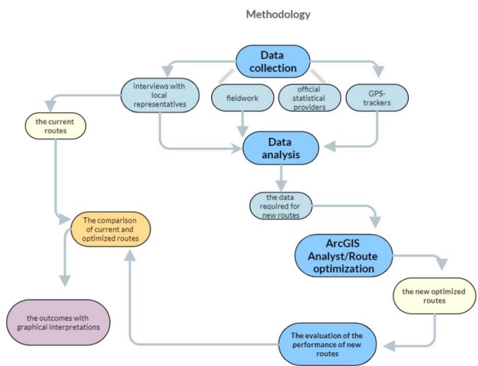
Figure 1: The Methodology with a Detailed Description
Source:Authors"own
### a) Fieldwork Study and Data Collection
In the research, two localities were selected for the pilot study - Mellieha and Attard due to different topographies: the town of Mellieha stands on a group of hills on the main island (the estimated terrain elevation above sea level is 150 meters) while the relief of Attard town is mostly flat in nature (the estimate terrain elevation above sea level is 78 meters). Therefore, the two case studies offer different challenges that can then be applied as an example for other localities that have similar topographical characteristics.
Waste collection occurs six days per week except on Sundays. It includes the collection of organic, recyclable, and mixed waste. The same route is used for the collection of different types of waste. In the research, the collection route for mixed waste is analyzed. Mixed waste collection takes place on Tuesday and Saturday.
An overview of waste management practices in Melloha and Attard is required to enhance the efficiency of the collection of MSW. Waste management data was collected for the period January 2021 - January 2022=. Maps from local municipalities, digital data from various official providers including the Malta National Statistics Office, ArcGIS Business Analyst and WasteServ Malta Ltd, interviews/meetings with local council representatives and fieldwork were the main data sources used for the route optimization. ArcGIS Business Analyst provides an overview of waste typology sectors. However, this information is not used in the calculations. This source was used in the research since it was difficult to obtain the information from official providers.
Detailed interviews with the local council representatives of Attard and Mellieha were conducted
to gain a deeper understanding of the MSW collection practices in two localities, methods and modes of waste transportation and collection, number, type and capacity of vehicles, schedule of transportation and collection waste, vehicles staff in the municipal solid waste collection process teams of the two cities.
Existing solid waste collection routes were obtained by GPS trackers Garmin GPSmap62 that were placed in waste collection vehicles. GPS tracker Garmin has high-sensitivity and helix antenna, WAAS/EGNOS-enabled GPS receiver with HotFix® satellite prediction,
GPSMAP 62 has unparalleled reception to determine the position precisely and quickly and maintains its GPS location (95 % accuracy) [9].
Each street was checked and analysed in terms of one/two- way movement while doing fieldwork. Both localities were visited more than 15 times during summer, winter and autumn to observe the traffic situation and waste collection process. The collected data is presented in Table 1.
Table 1: Collected Data for Route Optimisation in Attard and Mellieha
<table><tr><td>Collected Data</td><td>Source of Data</td><td>Website</td></tr><tr><td>road networks and characteristics of the streets (width, length, one/two-way), geographical boarders;</td><td>maps from local municipalities, fieldwork.</td><td>Online Database: https:// workflow.gov.mt/</td></tr><tr><td>traffic situation;</td><td>fieldwork, ArcGIS traffic service;</td><td></td></tr><tr><td>characteristics of the current municipal waste collection practices;</td><td>interview/meeting with local council representatives.</td><td></td></tr><tr><td>the current waste collection routes (their distance and time);</td><td>GPS trackers Garmin GPS map62;</td><td></td></tr><tr><td>population size, population density, total households, household size;</td><td>The Malta Statistics Office;</td><td>https://msa.gov.mt/</td></tr><tr><td>waste characteristics, waste typology sectors, waste generation rate;</td><td>WasteServ Malta Ltd (the company responsible for the waste collection service), ArcGIS Business Analyst;</td><td>https://wsm.com.mt/</td></tr><tr><td>type and number of collection vehicles; vehicle capacity and average fuel consumption;</td><td>interview/meeting with local council representatives.</td><td></td></tr></table>
### b) Data Analysis
To achieve the aim of the research, "to examine the current routes utilized in two localities of Malta for MSW collection and then use Geographic Information Systems (GIS) to optimize the present collection system," the following actions were taken:
1. Statistical Analysis of Demographic and Waste Data: Population size, population density, total households, household size, waste characteristics, and waste generation were statistically analyzed to understand the factors influencing waste generation and collection needs. This comprehensive analysis helped identify key demographic and waste factors crucial for optimizing the waste collection routes.
2. Measurement of Street Characteristics: The length and width of streets were manually measured using Google Maps, and each street was analyzed individually. Based on these measurements, streets were categorized as passable, non-passable, and occasionally impassable. This categorization provided essential information for routing analysis, ensuring that routes could accommodate collection vehicles efficiently. Moreover, turn delays, restricted turns, temporary road closures, and dead ends were analyzed.
3. Traffic Data Collection and Analysis: A web map of traffic provided by ArcGIS was utilized, offering near-real-time and historical traffic data feeds.
Additionally, traffic conditions were observed directly during fieldwork to assess real-time situations and historical trends. This traffic analysis was vital for minimizing delays and optimizing route efficiency by incorporating realistic traffic patterns.
4. Mapping Existing Waste Collection Routes: Existing solid waste collection routes and the location of the
landfill were mapped using GPS trackers (Garmin GPSmap62). The routes were divided into segments based on destination points. For instance, Figure 2 demonstrates an example of route classification in Attard, providing a clear visualization of existing waste collection paths and their segmentation.
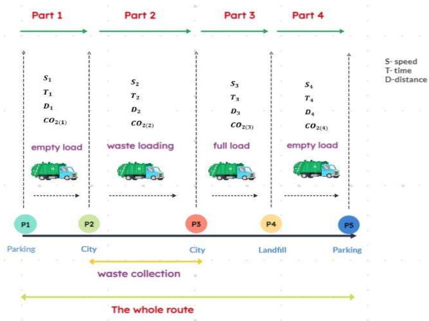
Figure 3: Speed formula.
Source:Authors"own
Figure 2: Route Classification based on the Destination Points in Attard
5. Calculation of Speed Mode, Emissions, and Fuel Consumption: Speed mode, travel time and distance, fuel consumption, and emissions of carbon dioxide $\left(\mathrm{CO}_{2}\right)$, nitrogen oxides $\left(\mathrm{NO}_{\mathrm{x}}\right)$, and particulate matter (PM) were calculated for each segment of the route. These calculations were based on the road type and truckload level. Since fuel consumption changes incrementally depending on the truck's load, higher loads typically result in greater fuel consumption, leading to varying levels of $\mathrm{CO}_{2}, \mathrm{NO}_{\mathrm{x}}$, and PM emissions. The following formula (Figure 3) was used to calculate average speed.
$$
s = \frac {d}{t} \tag {1}
$$
6. Topography Consideration: Topography was considered in fuel consumption calculations. Attard, being mostly flat, has a lower fuel consumption rate (28 liters per $100\mathrm{km}$ ) compared to Mellieha (30 liters per $100\mathrm{km}$ ), which is situated on a group of hills. Fuel consumption data from Volvo Truck Corporation, based on road type and load level, was used to adjust fuel consumption rates in both localities, factoring in topography, load level, and road type (Tables 2 and 3).
where is $s =$ speed, $d =$ distance travelled, $t =$ time elapsed.
Table 2: The Rates of Fuel Consumption in Mellieha.
<table><tr><td>Route Name</td><td>Level of Load</td><td>The Type of the Road</td><td>The Rate of Fuel</td></tr><tr><td>segment 1</td><td>empty load</td><td>arterials, distributors</td><td>27</td></tr><tr><td>Segment 2</td><td>loading</td><td>local access roads.</td><td>30</td></tr><tr><td>segment 3</td><td>full load</td><td>arterials, distributors</td><td>35</td></tr><tr><td>segment 4</td><td>loading</td><td>local access roads.</td><td>30</td></tr><tr><td>segment 5</td><td>full load</td><td>arterials, distributors</td><td>35</td></tr><tr><td>segment 6</td><td>empty load</td><td>arterials, distributors</td><td>27</td></tr></table>
Table 3: The Rates of Fuel Consumption in Attard.
<table><tr><td>Route Name</td><td>Level of Load</td><td>The Type of the Road</td><td>The Rate of Fuel</td></tr><tr><td>segment 1</td><td>empty load</td><td>arterials, distributors</td><td>27</td></tr><tr><td>segment2</td><td>loading</td><td>local access roads.</td><td>28</td></tr><tr><td>segment 3</td><td>full load</td><td>arterials, distributors</td><td>35</td></tr><tr><td>segment 4</td><td>empty load</td><td>arterials, distributors</td><td>27</td></tr></table>
7. Traffic Congestion Consideration: Traffic congestion was also considered in fuel consumption estimates. In congested traffic, vehicles typically burn between 0.6 to 1.2 liters of fuel per hour [10]. The congested streets in Attard include Triq Il-Pitkali, Triq in-Nutar Zarb, Triq iz-Zaghfran, Triq Il-Mosta, Triq Is-Salina, Triq Il-Fortizza Tal-Mosta (partly), and Triq Tal-Labour at 6:30 a.m. In Mellieha, the congested streets are Triq il-Mellieha, Triq Il-Marfa, Triq Il-Kbira, Triq Qasam Barrani, and Tul Il-Kosta at 6:30 a.m. Due to these traffic conditions, an additional 0.8 liters were added to the total fuel consumption in Attard, while one liter was added in Mellieha.
### c) Route optimizations and GIS Analyst
Geographic Information Systems (GIS) are sophisticated information systems used for tracking, managing, analysing, presenting, and storing data with a spatial distribution. GIS includes a spatially georeferenced database that encompasses the critical parameters necessary for effective solid waste management [11]. These parameters include the locations of landfills, city maps, transportation and collection road networks, and transfer stations [12]. GIS provides a powerful tool for optimising solid waste management by integrating diverse spatial data and offering robust analytical capabilities. Its ability to enhance decision-making through spatial analysis, efficient routing, and scenario planning makes it
indispensable for modern waste management strategies [11].
The route optimisation process included several key steps. The first step was the determination of collection points, which were generated based on the streets where waste collection occurs, ensuring comprehensive coverage of the service area. Secondly, the location of the landfill was identified, serving as the primary disposal point for the collected waste. Thirdly, the start and end points of each route were established to facilitate efficient waste collection operations. Additionally, the starting times for each route were selected to optimise traffic flow.
Traffic situations and road networks were analyzed using ArcGIS, incorporating both historical and real-time traffic data to minimise delays. The optimised routes were then determined using the Network Analyst extension in the GIS application. Routes were simulated multiple times, considering temporary road closures and non-passable streets. The use of non-passable streets was minimised to ensure optimal vehicle movement.
The selection criteria for the most optimised routes were determined based on specific segments of the route, considering the optimal time-to-distance ratio and minimization of travel time. Stop points were automatically allocated by the GIS application using the Network Analyst extension. Each collection point represented a specific address, but the actual addresses were modified to protect data privacy.
In summary, the route optimisation process ensured efficient waste collection through a structured methodology incorporating GIS analysis and the Network Analyst extension. This approach minimised delays and improved route efficiency while adhering to privacy regulations.
d) The Evaluation of the Performance of the Proposed Scenarios
The analysis output provided comprehensive data on travel time, distance, and stop frequency. Daily and annual computations were conducted to ascertain the aggregate emissions of $\mathrm{CO}_{2}$, nitrogen oxides, and particulates. Annual expenses were computed based on 314 operational days in 2022, factoring in the absence of waste collection on Sundays. Furthermore, seasonal variations in fuel consumption were considered, with an anticipated increase during summer (by up to 1 litre), attributed to heightened waste generation. Conversely, in Attard, a decrease of up to 1 litre during winter, autumn, and spring was observed due to GPS tracker implementation in August. Melleha exhibited a similar trend with fuel consumption escalation during summer, following GPS tracker installation in November.
A comparative analysis was conducted between proposed and current routes, evaluating enhancements in daily and annual travel metrics. Potential reductions in fuel consumption were examined, consequently leading to decreased emissions of $\mathrm{CO}_{2}$, nitrogen oxides, and particulates.
This section may be divided by subheadings. It should provide a concise and precise description of the experimental results, their interpretation, as well as the experimental conclusions that can be drawn.
## III. RESULTS
This section presents the development of new collection routes in two localities in Malta in detail including their evaluation and the comparisons with the existing collection routes.
The data was collected using GPS trackers Garmin GPSmap62, through fieldwork and face-to-face interviews with the local council representatives of Attard and Mellieha.
### a) Route Modeling for the Optimisation of Waste Collection and Transportation in Mellieha
## i. Proposed Scenario in Mellieha and Assessment of its Performance
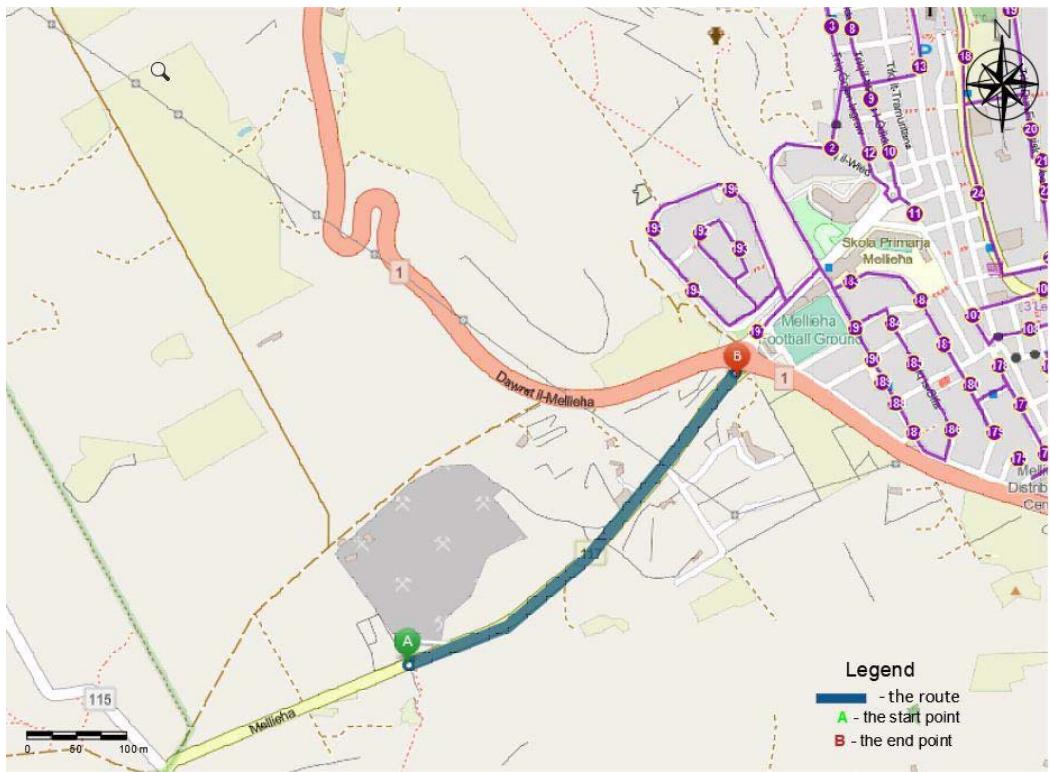
Based on travel mode (trucking time), traffic data and restrictions adopted in ArcGIS Network Analyst, such as temporary road closure during schooling time, turn delays and restricted turns, optimal routes are developed. Figure 4 represents the optimised route for the second segment of the route. While Figure 5 indicates the total route in Mellieha. Optimised routes for the 5 segments of the route are shown in Appendix A. The detailed route is described in Appendix B.
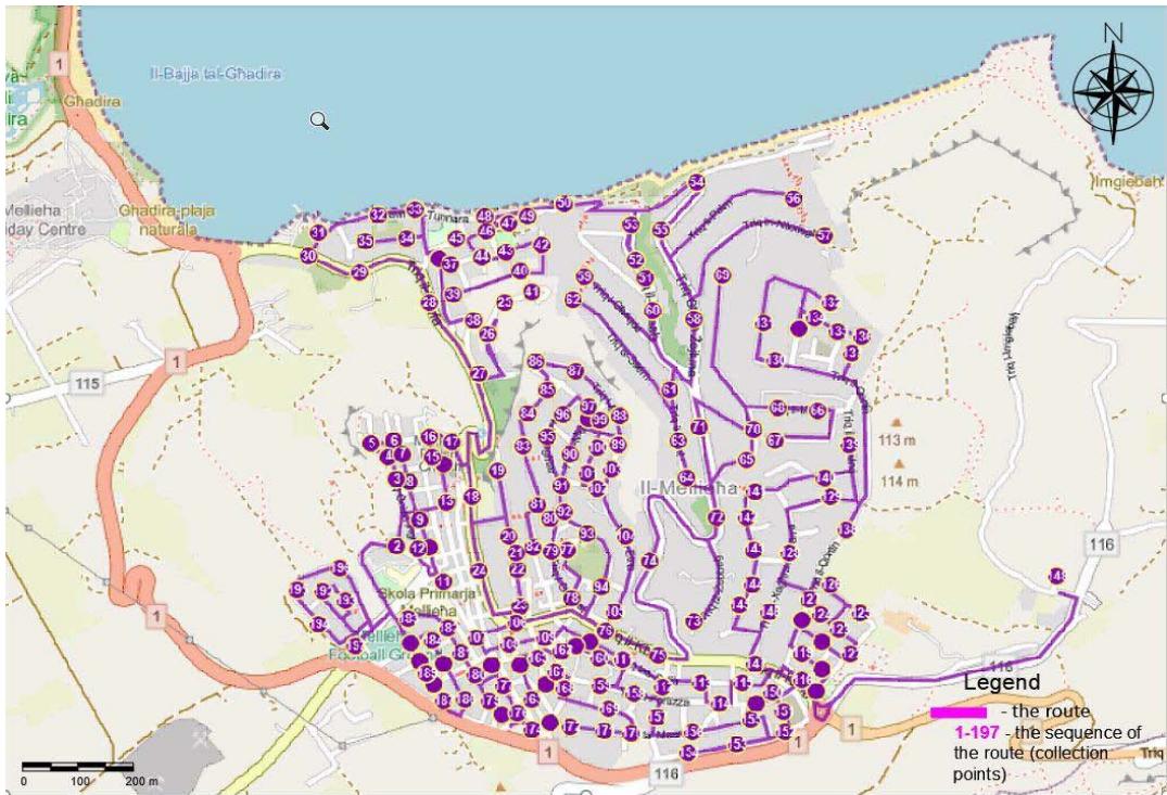
Source:Authors"own Figure 4: The Second Segment of the Optimized Route in Mellieha
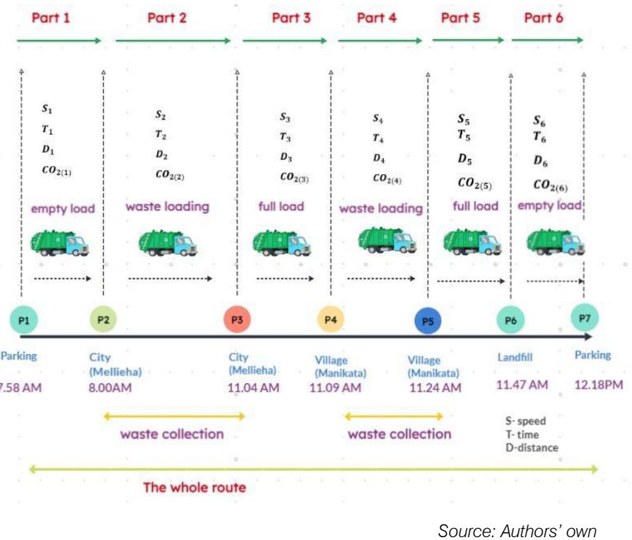
Figure 5: The proposed route in Mellieha
Travelled time, distance and the number of stops were obtained in the output of analysis. The data regarding the segments of the route are shown in Table 4. Overall traveling time and distance, as well as the number of stops along the route, were computed as the
sum of route segments, while average speed was determined as the mean of route segments. The total duration of the route is 4 hours 21 minutes including 3 minutes at the landfill. The total distance is $66.75 \mathrm{~km}$.
Table 4: The Calculations of the Proposed Scenario in Mellieha
<table><tr><td>Route Name</td><td>Stop Count</td><td>Time (Minutes)</td><td>Distance (Kilometers)</td><td>Average Speed</td></tr><tr><td>Segment 1</td><td>2</td><td>2</td><td>0.688</td><td>20</td></tr><tr><td>Segment 2</td><td>195</td><td>184</td><td>36.97</td><td>12</td></tr><tr><td>Segment 3</td><td>2</td><td>5</td><td>2.24</td><td>26.88</td></tr><tr><td>Segment 4</td><td>2</td><td>15</td><td>2.42</td><td>9.6</td></tr><tr><td>Segment 5</td><td>2</td><td>23</td><td>11.2</td><td>29</td></tr><tr><td>Segment 6</td><td>2</td><td>28</td><td>13.24</td><td>28</td></tr><tr><td>Total route</td><td>205</td><td>257</td><td>66.75</td><td>20.4</td></tr></table>
The amount of fuel consumed varies significantly depending on traffic conditions, road types, driving style, and the vehicle's load level. Fuel consumption and emissions were calculated based on the values for Volvo engines, as presented in Appendix C. The total fuel consumption for the route is 21.17 liters (Table 5). The corresponding emissions include 55.04 kg of $\mathrm{CO}_{2}$, 148.19 g of nitrogen oxides, and 2.12 g of particulate matter.
Table 5: Fuel Consumption and Emission Calculations of the Proposed Scenario in Mellieha.
<table><tr><td>Route Name</td><td>Level of Load</td><td>Distance (kilometers)</td><td>Fuel Consumption</td><td>CO2 kg/litre</td><td>NOx g/litre</td><td>PM g/litre</td></tr><tr><td>Segment 1</td><td>empty load</td><td>0.688</td><td>0.19</td><td>0.48</td><td>1.30</td><td>0.02</td></tr><tr><td>Segment2</td><td>loading</td><td>36.97</td><td>11.00</td><td>28.60</td><td>77.00</td><td>1.10</td></tr><tr><td>Segment 3</td><td>full load</td><td>2.24</td><td>0.78</td><td>2.04</td><td>5.49</td><td>0.08</td></tr><tr><td>Segment 4</td><td>loading</td><td>2.42</td><td>0.70</td><td>1.82</td><td>4.90</td><td>0.07</td></tr><tr><td>Segment 5</td><td>full load</td><td>11.2</td><td>4.40</td><td>11.44</td><td>30.80</td><td>0.44</td></tr><tr><td>Segment 6</td><td>empty load</td><td>13.24</td><td>4.10</td><td>10.66</td><td>28.70</td><td>0.41</td></tr><tr><td>Total route</td><td></td><td>66.758</td><td>21.17</td><td>55.04</td><td>148.19</td><td>2.12</td></tr></table>
## ii. The Comparison of Current and Optimised Routes in Mellieha
The current waste collection route distance in Melloha is $78.4\mathrm{km}$ and the time needed is 5 hours 18 minutes while the proposed collection route length is $66.7\mathrm{km}$ and the time needed is 4 hours 17 minutes. The current route of waste collection in Melloha covers a total of 24,617 kilometers and 99,852 minutes annually while the proposed route is 20,943 kilometers and 80,698 minutes annually. Thus, the proposed route will save up to 3,673 kilometers and 19,154 minutes annually (15 percent and 19 percent improvements compared to the current route).
The current route fuel consumption is 25.03 litres per day while the proposed route fuel consumption is 21.7 litres per day. Annual fuel consumption reaches up to 7,859 litres whereas the proposed route burns 6,647 litres of fuel. Hence, the potential savings are 1,212 litres of fuel annually.
Carbon dioxide, nitrogen oxides, and particulates are formed by the combustion of fuel. The amount of carbon dioxide, nitrogen oxide, and particulates produced by the current route is 65.07 kg; 175.18 g and 2.5 g respectively while the proposed route produces 55 kg of carbon dioxide, 148 g of nitrogen oxide and 2.1 g of particulates. The emissions of carbon dioxide, nitrogen oxide, and particulates reach 20,413 kg; 55,006 g; and 785 g annually by the current route whereas the proposed route emits 17,282 kg of carbon dioxide, 46,531 g of nitrogen oxide and 665 g of particulates on annual basis. Subsequently, the application of the proposed route will lead to the saving of 3,149 kg of carbon dioxide, 8,474 g of nitrogen oxide and 119.3 g of particulates reduction annually (up to 15 percent improvement compared to the current route). Detailed calculations are provided in Tables 6-7.
Table 6: The Comparison of Current and Proposed Routes in Mellieha for Time and Distance Criteria.
<table><tr><td></td><td>Route Name</td><td>Time (minutes)</td><td>Distance (kilometers)</td></tr><tr><td rowspan="7">Current route</td><td>Segment 1</td><td>2</td><td>0.688</td></tr><tr><td>Segment2</td><td>240</td><td>46.85</td></tr><tr><td>Segment 3</td><td>4</td><td>2.24</td></tr><tr><td>Segment 4</td><td>15</td><td>2.42</td></tr><tr><td>Segment 5</td><td>22</td><td>11.28</td></tr><tr><td>Segment 6</td><td>35</td><td>14.95</td></tr><tr><td>Total route</td><td>318</td><td>78.428</td></tr><tr><td></td><td>Route Name</td><td>Time (minutes)</td><td>Distance (kilometers)</td></tr><tr><td rowspan="7">proposed route</td><td>Segment 1</td><td>2</td><td>0.688</td></tr><tr><td>Segment2</td><td>184</td><td>36.97</td></tr><tr><td>Segment 3</td><td>5</td><td>2.24</td></tr><tr><td>Segment 4</td><td>15</td><td>2.42</td></tr><tr><td>Segment 5</td><td>23</td><td>11.2</td></tr><tr><td>Segment 6</td><td>28</td><td>13.24</td></tr><tr><td>Total route</td><td>257</td><td>66.758</td></tr></table>
Table 7: The comparison of current and proposed routes in Mellieha for time, distance, fuel consumption and emission criteria.
<table><tr><td></td><td>Current Route</td><td>Proposed Route</td><td>Improvement from Current Route</td><td>Improvement on Current Route %</td></tr><tr><td>Distance(km), day</td><td>78.4</td><td>66.7</td><td>11.7</td><td>15</td></tr><tr><td>Distance(km), year</td><td>24617.6</td><td>20943.8</td><td>3673.8</td><td>15</td></tr><tr><td>Time (min), day</td><td>318</td><td>257</td><td>61</td><td>19</td></tr><tr><td>Time (min), year</td><td>99852</td><td>80698</td><td>19154</td><td>19</td></tr><tr><td>Fuel Consumption(litre), day</td><td>25.03</td><td>21.17</td><td>3.86</td><td>15</td></tr><tr><td>Fuel Consumption(litre), year</td><td>7859.42</td><td>6647.38</td><td>1212.04</td><td>15</td></tr><tr><td>CO2 kg/litre, day</td><td>65.07</td><td>55.04</td><td>10.03</td><td>15</td></tr><tr><td>CO2 kg/litre, year</td><td>20431.98</td><td>17282.56</td><td>3149.42</td><td>15</td></tr><tr><td>NOx g/litre, day</td><td>175.18</td><td>148.19</td><td>26.99</td><td>15</td></tr><tr><td>NOx g/litre, year</td><td>55006.52</td><td>46531.66</td><td>8474.86</td><td>15</td></tr><tr><td>PM g/litre, day</td><td>2.5</td><td>2.12</td><td>0.38</td><td>15</td></tr><tr><td>PM g/litre, year</td><td>785</td><td>665.68</td><td>119.32</td><td>15</td></tr></table>
### b) Route Modeling for the Optimization of Waste Collection and Transportation in Attard
## IV. DISCUSSION
EconEconomic growth, rapid urbanisation, population growth, and improved community living standards have significantly accelerated the rate of waste generation worldwide. Malta faces a demographic challenge that could affect economic growth and fiscal spending for the next two decades. The percentage of the population aged 65 and older is increasing, while the percentage of those aged 0-14 is decreasing. Additionally, Malta has experienced steady economic growth due to its favorable tax environment. If progressive immigration policies are implemented and economic growth continues at the current rate, the population is projected to increase by $60\%$ over the next seventeen years, leading to higher consumption and greater waste generation.
Local municipalities are generally responsible for waste management in cities, struggle to provide effective systems for residents. They often face problems that exceed their capacity due to a lack of organization, financial resources, and the complexity of the system. Waste collection is the most expensive component of the waste management process, accounting for up to $75\%$ of total costs in the Municipal Solid Waste (MSW) management system. Most of these costs are related to fuel consumption, as solid waste collection is primarily carried out by fuel-powered trucks. These trucks emit pollutants into the atmosphere, predominantly carbon dioxide, nitrogen oxides, and sulfur dioxide, which are toxic to humans and contribute to acid rain and global warming.
The aim of this research was to analyse the current routes used in two localities of Malta for Municipal Solid Waste collection and then leverage GIS to optimise the existing collection system. To accomplish this aim, a comprehensive methodology was developed encompassing four main steps: fieldwork study and data collection, data analysis, GIS analysis and route optimization, and evaluation of the proposed scenarios' performance.
Data was collected using Garmin GPSmap62 GPS trackers, fieldwork, and face-to-face interviews with local council representatives in Attard and Mellieha. The optimised routes were determined using ArcGIS and the Network Analyst extension, taking into account road restrictions, traffic conditions, and street characteristics. Travel distance, time, fuel consumption, and emissions were calculated based on the load levels of the trucks. The application of Network Analyst demonstrated substantial cost savings by reducing fuel expenses, kilometers driven, and total travel time.
In Attard, the current waste collection route covers 44.1 km and requires 3 hours and 44 minutes daily, while the proposed collection route spans 37.73 km and takes 2 hours and 56 minutes. Thus, the proposed route will save up to 2,000 kilometers and 15,072 minutes annually, representing a $14\%$ reduction in distance and a $21\%$ improvement in time compared to the current route. The proposed route will result in annual savings of 593 liters of fuel and reduce emissions by 1,545 kg of carbon dioxide, 4,161 g of nitrogen oxide, and 59 g of particulates.
In Melloha, the current waste collection route covers 78.4 km and takes 5 hours and 18 minutes daily, while the proposed collection route spans 66.7 km and
requires 4 hours and 17 minutes. Consequently, the proposed route will save up to 3,673 kilometers and 19,154 minutes annually, representing a $15\%$ reduction in distance and a $19\%$ improvement in time compared to the current route. The proposed route will result in annual savings of 1,212 liters of fuel and reduce emissions by 3,149 kg of carbon dioxide, 8,474 g of nitrogen oxide, and 119.3 g of particulates.
In summary, the route optimization was successfully achieved in both localities. The results clearly demonstrate that the proposed routes are more efficient in terms of collection time and distance traveled. These improvements are directly correlated with decreased fuel consumption, leading to a reduction in carbon dioxide, nitrogen oxide, and particulate emissions.
## V. CONCLUSIONS AND RECOMMENDATIONS
This research effectively optimized waste collection routes in two localities of Malta using GIS. The findings unequivocally indicate that the proposed routes are more efficient in terms of collection time and distance traveled. These improvements are highly correlated with decreased fuel consumption, leading to a significant reduction in carbon dioxide, nitrogen oxide, and particulate emissions.
Based on the findings of this research, the following recommendations are proposed to enhance the efficiency of waste collection in Malta:
Waste Collection Schedule: Traffic congestion was observed during fieldwork, particularly in the morning, creating significant difficulties for residents and vehicles and hindering efficient waste collection. Shifting the waste collection schedule to evening or nighttime hours could improve efficiency by avoiding traffic jams and minimizing the negative impact of leaving waste outside for extended periods. Spain is an example of a country that collects waste efficiently in the evening or night.
Utilising ArcGIS Network Analyst Extension: ArcGIS, with its Network Analyst extension, is a valuable tool for route optimization. Applying this tool could improve the efficiency of not just municipal solid waste collection but also construction waste collection. Other types of waste collection can also be considered.
Adaptability of the Models: The proposed models are highly adaptable and could be applied in various locations within the country and beyond, particularly in developing countries facing significant challenges in solid waste management. However, accurate knowledge of the waste generation rate, road network, and road restrictions is required to achieve optimal results.
Practical Applications: The research offers a straightforward decision to the current problem. The models that were developed in the research have
practical applications. It is expected that local municipalities will consider the results of the research physically and empirically while making decisions regarding the waste collection process.
### Future Research Directions
Multiple Truck Routes: Developing routes using multiple trucks could increase the efficiency of the waste collection process. However, this recommendation depends on the budget allocated for waste collection, as utilising multiple trucks may be more expensive than using a single truck.
Evening or Night-Time Optimisation: The proposed models could be modified and simulated for evening or nighttime hours. This shift would enhance the performance of the waste collection process by avoiding congestion.
Author Contributions: Conceptualization, M.C. -F. and L.A.; methodology, L.A.; software, L.A.; validation, M.C. -F.; resources, M.C. -F.; data curation, L.A.; writing—original draft preparation, L.A.; writing-review and editing, M.C. -F.; visualization, L.A.; supervision, M.C. -F.; project administration, M.C. -F. T.B. writing review. All authors have read and agreed to the published version of the manuscript.
Funding: This research received no external funding.
Institutional Review Board Statement: Not applicable.
Data Availability Statement:
#### ACKNOWLEDGMENTS
We are immensely grateful to the University of Malta for providing the opportunity to embark on this research project. Our appreciation extends to Romina Zammit, whose kindness and compassionate support with all administrative formalities over the last 1.5 years have been indispensable.
Our thanks also go to the local council representatives of Attard and Mellieha for their cooperation and assistance. Additionally, we acknowledge the representatives from WasteServ for providing crucial data regarding the current waste collection routes, which was essential for our study.
Lastly, we are eternally thankful to our families for their unconditional love, moral support, and care. Their presence has been a cornerstone throughout the research process and continues to enrich our lives daily.
Conflicts of Interest: The authors declare no conflicts of interest.
APPENDIX A
Source:Authors' own
Figure A1: The First Segment of the Optimized Route in Mellieha
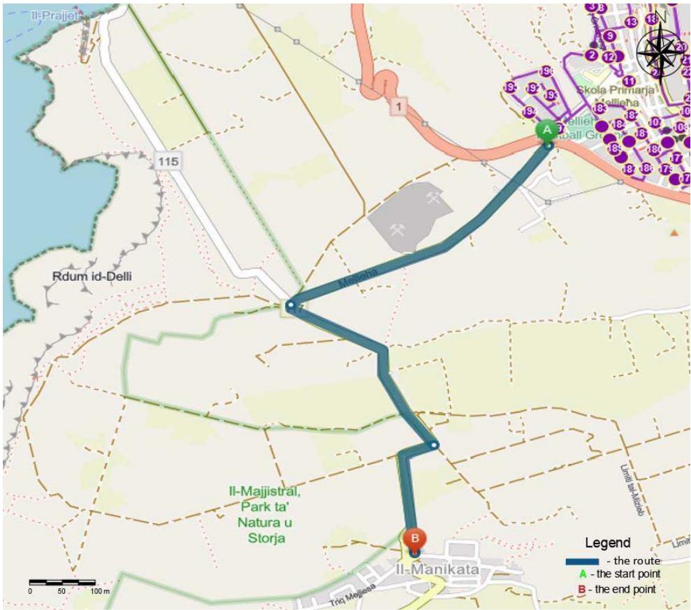
Figure A2: The Third Segment of the Optimized Route in Mellieha
Source:Authors' own
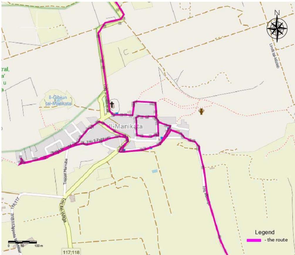
Source:Authors' own
Figure A3: The Fourth Segment of the Optimized Route in Mellieha
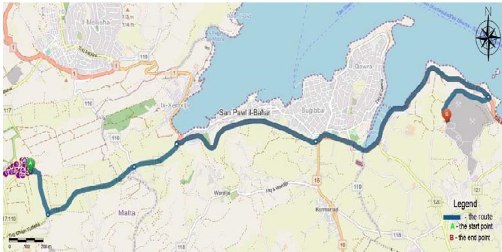
Figure A4: The Fifth Segment of the Optimized Route in Mellieha
Source:Authors' own
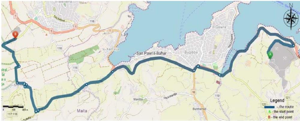
Source:Authors' own Figure A5: The Sixth Segment of the Optimized Route in Mellieha
#### APPENDIX B
Table B1: The Proposed Route in Mellieha.
<table><tr><td>Route Name</td><td>Sequence</td><td>Travel Distance from Previous Stop (Kilometers)</td><td>Address</td></tr><tr><td>Start Depot - 1 - Route1</td><td>1</td><td>0</td><td>Address 1</td></tr><tr><td>Start Depot - 1 - Route1</td><td>2</td><td>0.43583</td><td>Address 2</td></tr><tr><td>Start Depot - 1 - Route1</td><td>3</td><td>0.19057</td><td>Address 3</td></tr><tr><td>Start Depot - 1 - Route1</td><td>4</td><td>0.07226</td><td>Address 4</td></tr><tr><td>Start Depot - 1 - Route1</td><td>5</td><td>0.06558</td><td>Address 5</td></tr><tr><td>Start Depot - 1 - Route1</td><td>6</td><td>0.06372</td><td>Address 6</td></tr><tr><td>Start Depot - 1 - Route1</td><td>7</td><td>0.05423</td><td>Address 7</td></tr><tr><td>Start Depot - 1 - Route1</td><td>8</td><td>0.07942</td><td>Address 8</td></tr><tr><td>Start Depot - 1 - Route1</td><td>9</td><td>0.11259</td><td>Address 9</td></tr><tr><td>Start Depot - 1 - Route1</td><td>10</td><td>0.0854</td><td>Address 10</td></tr><tr><td>Start Depot - 1 - Route1</td><td>11</td><td>0.10931</td><td>Address 11</td></tr><tr><td>Start Depot - 1 - Route1</td><td>12</td><td>0.14212</td><td>Address 12</td></tr><tr><td>Start Depot - 1 - Route1</td><td>13</td><td>0.23691</td><td>Address 13</td></tr><tr><td>Start Depot - 1 - Route1</td><td>14</td><td>0.10184</td><td>Address 14</td></tr><tr><td>Start Depot - 1 - Route1</td><td>15</td><td>0.04496</td><td>Address 15</td></tr><tr><td>Start Depot - 1 - Route1</td><td>16</td><td>0.06632</td><td>Address 16</td></tr><tr><td>Start Depot - 1 - Route1</td><td>17</td><td>0.07825</td><td>Address 17</td></tr><tr><td>Start Depot - 1 - Route1</td><td>18</td><td>0.17582</td><td>Address 18</td></tr><tr><td>Start Depot - 1 - Route1</td><td>19</td><td>0.29804</td><td>Address 19</td></tr><tr><td>Start Depot - 1 - Route1</td><td>20</td><td>0.18468</td><td>Address 20</td></tr><tr><td>Start Depot - 1 - Route1</td><td>21</td><td>0.05987</td><td>Address 21</td></tr><tr><td>Start Depot - 1 - Route1</td><td>22</td><td>0.0471</td><td>Address 22</td></tr><tr><td>Start Depot - 1 - Route1</td><td>23</td><td>0.10133</td><td>Address 23</td></tr><tr><td>Start Depot - 1 - Route1</td><td>24</td><td>0.22883</td><td>Address 24</td></tr><tr><td>Start Depot - 1 - Route1</td><td>25</td><td>0.9564</td><td>Address 25</td></tr><tr><td>Start Depot - 1 - Route1</td><td>26</td><td>0.0492</td><td>Address 26</td></tr><tr><td>Start Depot - 1 - Route1</td><td>27</td><td>0.20551</td><td>Address 27</td></tr><tr><td>Start Depot - 1 - Route1</td><td>28</td><td>0.29058</td><td>Address 28</td></tr><tr><td>Start Depot - 1 - Route1</td><td>29</td><td>0.27474</td><td>Address 29</td></tr><tr><td>Start Depot - 1 - Route1</td><td>30</td><td>0.15214</td><td>Address 30</td></tr><tr><td>Start Depot - 1 - Route1</td><td>31</td><td>0.06624</td><td>Address 31</td></tr><tr><td>Start Depot - 1 - Route1</td><td>32</td><td>0.1728</td><td>Address 32</td></tr><tr><td>Start Depot - 1 - Route1</td><td>33</td><td>0.1015</td><td>Address 33</td></tr><tr><td>Start Depot - 1 - Route1</td><td>34</td><td>0.13441</td><td>Address 34</td></tr><tr><td>Start Depot - 1 - Route1</td><td>35</td><td>0.11152</td><td>Address 35</td></tr><tr><td>Start Depot - 1 - Route1</td><td>36</td><td>0.26123</td><td>Address 36</td></tr><tr><td>Start Depot - 1 - Route1</td><td>37</td><td>0.06373</td><td>Address 37</td></tr><tr><td>Start Depot - 1 - Route1</td><td>38</td><td>0.24963</td><td>Address 38</td></tr><tr><td>Start Depot - 1 - Route1</td><td>39</td><td>0.16911</td><td>Address 39</td></tr><tr><td>Start Depot - 1 - Route1</td><td>40</td><td>0.19214</td><td>Address 40</td></tr><tr><td>Start Depot - 1 - Route1</td><td>41</td><td>0.03327</td><td>Address 41</td></tr><tr><td>Start Depot - 1 - Route1</td><td>42</td><td>0.10485</td><td>Address 42</td></tr><tr><td>Start Depot - 1 - Route1</td><td>43</td><td>0.1233</td><td>Address 43</td></tr><tr><td>Start Depot - 1 - Route1</td><td>44</td><td>0.0775</td><td>Address 44</td></tr><tr><td>Start Depot - 1 - Route1</td><td>45</td><td>0.08821</td><td>Address 45</td></tr><tr><td>Start Depot - 1 - Route1</td><td>46</td><td>0.08391</td><td>Address 46</td></tr><tr><td>Start Depot - 1 - Route1</td><td>47</td><td>0.06388</td><td>Address 47</td></tr><tr><td>Start Depot - 1 - Route1</td><td>48</td><td>0.08458</td><td>Address 48</td></tr><tr><td>Start Depot - 1 - Route1</td><td>49</td><td>0.11594</td><td>Address 49</td></tr><tr><td>Start Depot - 1 - Route1</td><td>50</td><td>0.2616</td><td>Address 50</td></tr><tr><td>Start Depot - 1 - Route1</td><td>51</td><td>0.48044</td><td>Address 51</td></tr><tr><td>Start Depot - 1 - Route1</td><td>52</td><td>0.05711</td><td>Address 52</td></tr><tr><td>Start Depot - 1 - Route1</td><td>53</td><td>0.10759</td><td>Address 53</td></tr><tr><td>Start Depot - 1 - Route1</td><td>54</td><td>0.24538</td><td>Address 54</td></tr><tr><td>Start Depot - 1 - Route1</td><td>55</td><td>0.18496</td><td>Address 55</td></tr><tr><td>Start Depot - 1 - Route1</td><td>56</td><td>0.49137</td><td>Address 56</td></tr><tr><td>Start Depot - 1 - Route1</td><td>57</td><td>1.03836</td><td>Address 57</td></tr><tr><td>Start Depot - 1 - Route1</td><td>58</td><td>0.56074</td><td>Address 58</td></tr><tr><td>Start Depot - 1 - Route1</td><td>59</td><td>0.61258</td><td>Address 59</td></tr><tr><td>Start Depot - 1 - Route1</td><td>60</td><td>0.36105</td><td>Address 60</td></tr><tr><td>Start Depot - 1 - Route1</td><td>61</td><td>0.24549</td><td>Address 61</td></tr><tr><td>Start Depot - 1 - Route1</td><td>62</td><td>0.50647</td><td>Address 62</td></tr><tr><td>Start Depot - 1 - Route1</td><td>63</td><td>0.50511</td><td>Address 63</td></tr><tr><td>Start Depot - 1 - Route1</td><td>64</td><td>0.10069</td><td>Address 64</td></tr><tr><td>Start Depot - 1 - Route1</td><td>65</td><td>0.23984</td><td>Address 65</td></tr><tr><td>Start Depot - 1 - Route1</td><td>66</td><td>0.351</td><td>Address 66</td></tr><tr><td>Start Depot - 1 - Route1</td><td>67</td><td>0.28427</td><td>Address 67</td></tr><tr><td>Start Depot - 1 - Route1</td><td>68</td><td>0.38975</td><td>Address 68</td></tr><tr><td>Start Depot - 1 - Route1</td><td>69</td><td>0.4961</td><td>Address 69</td></tr><tr><td>Start Depot - 1 - Route1</td><td>70</td><td>0.47331</td><td>Address 70</td></tr><tr><td>Start Depot - 1 - Route1</td><td>71</td><td>0.27427</td><td>Address 71</td></tr><tr><td>Start Depot - 1 - Route1</td><td>72</td><td>0.26031</td><td>Address 72</td></tr><tr><td>Start Depot - 1 - Route1</td><td>73</td><td>0.33632</td><td>Address 73</td></tr><tr><td>Start Depot - 1 - Route1</td><td>74</td><td>0.67878</td><td>Address 74</td></tr><tr><td>Start Depot - 1 - Route1</td><td>75</td><td>0.45007</td><td>Address 75</td></tr><tr><td>Start Depot - 1 - Route1</td><td>76</td><td>0.15626</td><td>Address 76</td></tr><tr><td>Start Depot - 1 - Route1</td><td>77</td><td>0.30813</td><td>Address 77</td></tr><tr><td>Start Depot - 1 - Route1</td><td>78</td><td>0.16551</td><td>Address 78</td></tr><tr><td>Start Depot - 1 - Route1</td><td>79</td><td>0.14581</td><td>Address 79</td></tr><tr><td>Start Depot - 1 - Route1</td><td>80</td><td>0.09734</td><td>Address 80</td></tr><tr><td>Start Depot - 1 - Route1</td><td>81</td><td>0.05901</td><td>Address 81</td></tr><tr><td>Start Depot - 1 - Route1</td><td>82</td><td>0.12906</td><td>Address 82</td></tr><tr><td>Start Depot - 1 - Route1</td><td>83</td><td>0.30083</td><td>Address 83</td></tr><tr><td>Start Depot - 1 - Route1</td><td>84</td><td>0.10242</td><td>Address 84</td></tr><tr><td>Start Depot - 1 - Route1</td><td>85</td><td>0.08901</td><td>Address 85</td></tr><tr><td>Start Depot - 1 - Route1</td><td>86</td><td>0.10537</td><td>Address 86</td></tr><tr><td>Start Depot - 1 - Route1</td><td>87</td><td>0.11773</td><td>Address 87</td></tr><tr><td>Start Depot - 1 - Route1</td><td>88</td><td>0.17804</td><td>Address 88</td></tr><tr><td>Start Depot - 1 - Route1</td><td>89</td><td>0.07428</td><td>Address 89</td></tr><tr><td>Start Depot - 1 - Route1</td><td>90</td><td>0.20845</td><td>Address 90</td></tr><tr><td>Start Depot - 1 - Route1</td><td>91</td><td>0.09088</td><td>Address 91</td></tr><tr><td>Start Depot - 1 - Route1</td><td>92</td><td>0.08146</td><td>Address 92</td></tr><tr><td>Start Depot - 1 - Route1</td><td>93</td><td>0.08682</td><td>Address 93</td></tr><tr><td>Start Depot - 1 - Route1</td><td>94</td><td>0.18687</td><td>Address 94</td></tr><tr><td>Start Depot - 1 - Route1</td><td>95</td><td>0.63836</td><td>Address 95</td></tr><tr><td>Start Depot - 1 - Route1</td><td>96</td><td>0.07883</td><td>Address 96</td></tr><tr><td>Start Depot - 1 - Route1</td><td>97</td><td>0.09921</td><td>Address 97</td></tr><tr><td>Start Depot - 1 - Route1</td><td>98</td><td>0.05029</td><td>Address 98</td></tr><tr><td>Start Depot - 1 - Route1</td><td>99</td><td>0.05749</td><td>Address 99</td></tr><tr><td>Start Depot - 1 - Route1</td><td>100</td><td>0.07604</td><td>Address 100</td></tr><tr><td>Start Depot - 1 - Route1</td><td>101</td><td>0.07738</td><td>Address 101</td></tr><tr><td>Start Depot - 1 - Route1</td><td>102</td><td>0.07216</td><td>Address 102</td></tr><tr><td>Start Depot - 1 - Route1</td><td>103</td><td>0.08529</td><td>Address 103</td></tr><tr><td>Start Depot - 1 - Route1</td><td>104</td><td>0.21469</td><td>Address 104</td></tr><tr><td>Start Depot - 1 - Route1</td><td>105</td><td>0.22405</td><td>Address 105</td></tr><tr><td>Start Depot - 1 - Route1</td><td>106</td><td>0.31518</td><td>Address 106</td></tr><tr><td>Start Depot - 1 - Route1</td><td>107</td><td>0.12945</td><td>Address 107</td></tr><tr><td>Start Depot - 1 - Route1</td><td>108</td><td>0.11933</td><td>Address 108</td></tr><tr><td>Start Depot - 1 - Route1</td><td>109</td><td>0.10127</td><td>Address 109</td></tr><tr><td>Start Depot - 1 - Route1</td><td>110</td><td>0.14952</td><td>Address 110</td></tr><tr><td>Start Depot - 1 - Route1</td><td>111</td><td>0.10166</td><td>Address 111</td></tr><tr><td>Start Depot - 1 - Route1</td><td>112</td><td>0.15086</td><td>Address 112</td></tr><tr><td>Start Depot - 1 - Route1</td><td>113</td><td>0.12289</td><td>Address 113</td></tr><tr><td>Start Depot - 1 - Route1</td><td>114</td><td>0.11051</td><td>Address 114</td></tr><tr><td>Start Depot - 1 - Route1</td><td>115</td><td>0.12509</td><td>Address 115</td></tr><tr><td>Start Depot - 1 - Route1</td><td>116</td><td>0.22379</td><td>Address 116</td></tr><tr><td>Start Depot - 1 - Route1</td><td>117</td><td>0.0489</td><td>Address 117</td></tr><tr><td>Start Depot - 1 - Route1</td><td>118</td><td>0.07935</td><td>Address 118</td></tr><tr><td>Start Depot - 1 - Route1</td><td>119</td><td>0.06884</td><td>Address 119</td></tr><tr><td>Start Depot - 1 - Route1</td><td>120</td><td>0.11803</td><td>Address 120</td></tr><tr><td>Start Depot - 1 - Route1</td><td>121</td><td>0.09702</td><td>Address 121</td></tr><tr><td>Start Depot - 1 - Route1</td><td>122</td><td>0.10142</td><td>Address 122</td></tr><tr><td>Start Depot - 1 - Route1</td><td>123</td><td>0.0875</td><td>Address 123</td></tr><tr><td>Start Depot - 1 - Route1</td><td>124</td><td>0.06865</td><td>Address 124</td></tr><tr><td>Start Depot - 1 - Route1</td><td>125</td><td>0.15161</td><td>Address 125</td></tr><tr><td>Start Depot - 1 - Route1</td><td>126</td><td>0.11177</td><td>Address 126</td></tr><tr><td>Start Depot - 1 - Route1</td><td>127</td><td>0.09985</td><td>Address 127</td></tr><tr><td>Start Depot - 1 - Route1</td><td>128</td><td>0.1939</td><td>Address 128</td></tr><tr><td>Start Depot - 1 - Route1</td><td>129</td><td>0.24688</td><td>Address 129</td></tr><tr><td>Start Depot - 1 - Route1</td><td>130</td><td>0.66543</td><td>Address 130</td></tr><tr><td>Start Depot - 1 - Route1</td><td>131</td><td>0.15791</td><td>Address 131</td></tr><tr><td>Start Depot - 1 - Route1</td><td>132</td><td>0.31105</td><td>Address 132</td></tr><tr><td>Start Depot - 1 - Route1</td><td>133</td><td>0.19159</td><td>Address 133</td></tr><tr><td>Start Depot - 1 - Route1</td><td>134</td><td>0.09208</td><td>Address 134</td></tr><tr><td>Start Depot - 1 - Route1</td><td>135</td><td>0.07277</td><td>Address 135</td></tr><tr><td>Start Depot - 1 - Route1</td><td>136</td><td>0.07394</td><td>Address 136</td></tr><tr><td>Start Depot - 1 - Route1</td><td>137</td><td>0.04926</td><td>Address 137</td></tr><tr><td>Start Depot - 1 - Route1</td><td>138</td><td>0.54147</td><td>Address 138</td></tr><tr><td>Start Depot - 1 - Route1</td><td>139</td><td>0.25462</td><td>Address 139</td></tr><tr><td>Start Depot - 1 - Route1</td><td>140</td><td>0.15436</td><td>Address 140</td></tr><tr><td>Start Depot - 1 - Route1</td><td>141</td><td>0.20085</td><td>Address 141</td></tr><tr><td>Start Depot - 1 - Route1</td><td>142</td><td>0.08969</td><td>Address 142</td></tr><tr><td>Start Depot - 1 - Route1</td><td>143</td><td>0.09143</td><td>Address 143</td></tr><tr><td>Start Depot - 1 - Route1</td><td>144</td><td>0.09879</td><td>Address 144</td></tr><tr><td>Start Depot - 1 - Route1</td><td>145</td><td>0.06878</td><td>Address 145</td></tr><tr><td>Start Depot - 1 - Route1</td><td>146</td><td>0.20737</td><td>Address 146</td></tr><tr><td>Start Depot - 1 - Route1</td><td>147</td><td>0.17209</td><td>Address 147</td></tr><tr><td>Start Depot - 1 - Route1</td><td>148</td><td>1.11101</td><td>Address 148</td></tr><tr><td>Start Depot - 1 - Route1</td><td>149</td><td>1.17521</td><td>Address 149</td></tr><tr><td>Start Depot - 1 - Route1</td><td>150</td><td>0.0797</td><td>Address 150</td></tr><tr><td>Start Depot - 1 - Route1</td><td>151</td><td>0.06385</td><td>Address 151</td></tr><tr><td>Start Depot - 1 - Route1</td><td>152</td><td>0.07764</td><td>Address 152</td></tr><tr><td>Start Depot - 1 - Route1</td><td>153</td><td>0.13444</td><td>Address 153</td></tr><tr><td>Start Depot - 1 - Route1</td><td>154</td><td>0.1364</td><td>Address 154</td></tr><tr><td>Start Depot - 1 - Route1</td><td>155</td><td>0.32648</td><td>Address 155</td></tr><tr><td>Start Depot - 1 - Route1</td><td>156</td><td>0.16395</td><td>Address 156</td></tr><tr><td>Start Depot - 1 - Route1</td><td>157</td><td>0.16442</td><td>Address 157</td></tr><tr><td>Start Depot-1-Route1</td><td>158</td><td>0.11654</td><td>Address 158</td></tr><tr><td>Start Depot-1-Route1</td><td>159</td><td>0.09606</td><td>Address 159</td></tr><tr><td>Start Depot-1-Route1</td><td>160</td><td>0.17451</td><td>Address 160</td></tr><tr><td>Start Depot-1-Route1</td><td>161</td><td>0.07295</td><td>Address 161</td></tr><tr><td>Start Depot-1-Route1</td><td>162</td><td>0.05379</td><td>Address 162</td></tr><tr><td>Start Depot-1-Route1</td><td>163</td><td>0.09681</td><td>Address 163</td></tr><tr><td>Start Depot-1-Route1</td><td>164</td><td>0.09133</td><td>Address 164</td></tr><tr><td>Start Depot-1-Route1</td><td>165</td><td>0.06377</td><td>Address 165</td></tr><tr><td>Start Depot-1-Route1</td><td>166</td><td>0.04451</td><td>Address 166</td></tr><tr><td>Start Depot-1-Route1</td><td>167</td><td>0.03733</td><td>Address 167</td></tr><tr><td>Start Depot-1-Route1</td><td>168</td><td>0.07533</td><td>Address 168</td></tr><tr><td>Start Depot-1-Route1</td><td>169</td><td>0.16041</td><td>Address 169</td></tr><tr><td>Start Depot-1-Route1</td><td>170</td><td>0.12242</td><td>Address 170</td></tr><tr><td>Start Depot-1-Route1</td><td>171</td><td>0.09681</td><td>Address 171</td></tr><tr><td>Start Depot-1-Route1</td><td>172</td><td>0.06027</td><td>Address 172</td></tr><tr><td>Start Depot-1-Route1</td><td>173</td><td>0.05284</td><td>Address 173</td></tr><tr><td>Start Depot-1-Route1</td><td>174</td><td>0.05284</td><td>Address 174</td></tr><tr><td>Start Depot-1-Route1</td><td>175</td><td>0.08784</td><td>Address 175</td></tr><tr><td>Start Depot-1-Route1</td><td>176</td><td>0.06983</td><td>Address 176</td></tr><tr><td>Start Depot-1-Route1</td><td>177</td><td>0.08272</td><td>Address 177</td></tr><tr><td>Start Depot-1-Route1</td><td>178</td><td>0.06843</td><td>Address 178</td></tr><tr><td>Start Depot-1-Route1</td><td>179</td><td>0.07615</td><td>Address 179</td></tr><tr><td>Start Depot-1-Route1</td><td>180</td><td>0.07677</td><td>Address 180</td></tr><tr><td>Start Depot-1-Route1</td><td>181</td><td>0.07677</td><td>Address 181</td></tr><tr><td>Start Depot-1-Route1</td><td>182</td><td>0.07677</td><td>Address 182</td></tr><tr><td>Start Depot-1-Route1</td><td>183</td><td>0.12679</td><td>Address 183</td></tr><tr><td>Start Depot-1-Route1</td><td>184</td><td>0.16966</td><td>Address 184</td></tr><tr><td>Start Depot-1-Route1</td><td>185</td><td>0.07024</td><td>Address 185</td></tr><tr><td>Start Depot-1-Route1</td><td>186</td><td>0.11942</td><td>Address 186</td></tr><tr><td>Start Depot-1-Route1</td><td>187</td><td>0.11942</td><td>Address 187</td></tr><tr><td>Start Depot-1-Route1</td><td>188</td><td>0.03776</td><td>Address 188</td></tr><tr><td>Start Depot-1-Route1</td><td>189</td><td>0.03776</td><td>Address 189</td></tr><tr><td>Start Depot-1-Route1</td><td>190</td><td>0.05454</td><td>Address 190</td></tr><tr><td>Start Depot-1-Route1</td><td>191</td><td>0.05416</td><td>Address 191</td></tr><tr><td>Start Depot-1-Route1</td><td>192</td><td>0.41136</td><td>Address 192</td></tr><tr><td>Start Depot-1-Route1</td><td>193</td><td>0.25263</td><td>Address 193</td></tr><tr><td>Start Depot-1-Route1</td><td>194</td><td>0.11217</td><td>Address 194</td></tr><tr><td>Start Depot-1-Route1</td><td>195</td><td>0.16058</td><td>Address 196</td></tr><tr><td>Start Depot-1-Route1</td><td>196</td><td>0.16058</td><td>Address 196</td></tr><tr><td>Start Depot-1-Route1</td><td>197</td><td>0.2599</td><td>Address 197</td></tr></table>
#### APPENDIX C
Table C1: Emission Factors per Litre Fuel Consumed, Volvo Dennis Eagle 2009.
<table><tr><td colspan="7">Typical values, based on certification measurements, for the more common Volvo engines, with EU certification diesel fuel</td></tr><tr><td>Car Standard</td><td>Law from</td><td>Volvo from</td><td>NOx g/litre</td><td>PM g/litre</td><td>HC g/litre</td><td>CO2 kg/litre</td></tr><tr><td>Euro 5</td><td>2009</td><td>2005</td><td>7</td><td>0.10</td><td>0.00</td><td>2.6</td></tr></table>
Table C2: Typical Fuel Consumption in Litres per 100 km, Volvo Dennis Eagle 2009.
<table><tr><td></td><td>Payload in Tons</td><td>Total Weight in Tons</td><td>Litres / 100 km Empty</td><td>Litre / 100 km Full Load</td></tr><tr><td>Truck</td><td>14</td><td>24</td><td>25-30</td><td>30-40</td></tr></table>
#### APPENDIX D
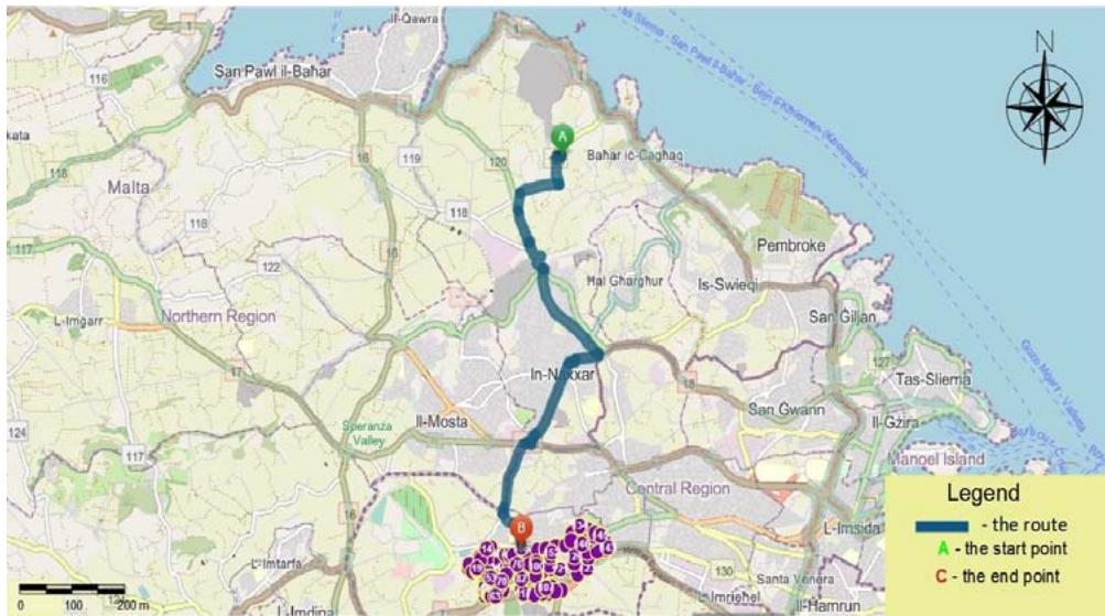
Figure D1: The First Segment of the Optimized Route in Attard.
Source:Authors' own
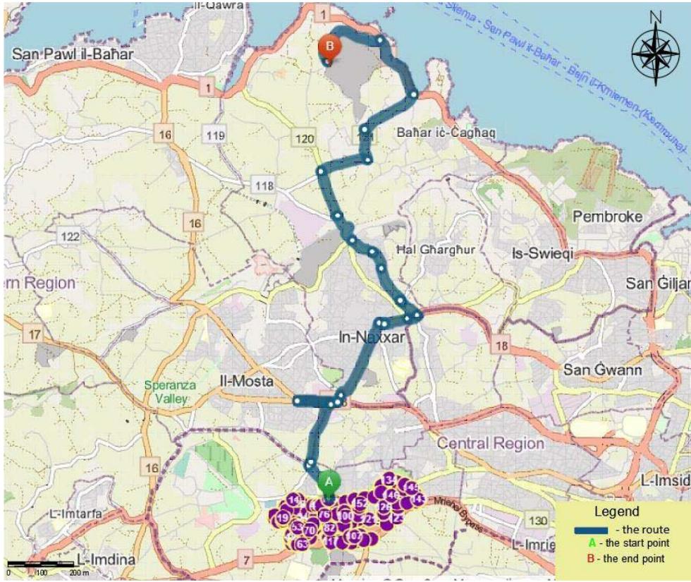
Source:Authors' own
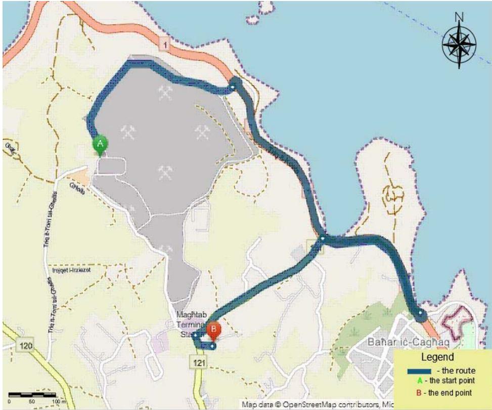
Figure D2: The Third Segment of the Optimized Route in Attard. Source:Authors' own Figure D3: The Fourth Segment of the Optimized Route in Attard.
#### APPENDIX E
Table E1: The Proposed Route in Attard.
<table><tr><td>Route Name</td><td>Sequence</td><td>Travel Distance from Previous Stop (Kilometers)</td><td>Address</td></tr><tr><td>Start Depot-1-Route 1</td><td>1</td><td>0</td><td>Address 1</td></tr><tr><td>Start Depot-1-Route 1</td><td>2</td><td>0.19</td><td>Address 2</td></tr><tr><td>Start Depot-1-Route 1</td><td>3</td><td>0.06</td><td>Address 3</td></tr><tr><td>Start Depot-1-Route 1</td><td>4</td><td>0.06</td><td>Address 4</td></tr><tr><td>Start Depot-1-Route 1</td><td>5</td><td>0.07</td><td>Address 5</td></tr><tr><td>Start Depot-1-Route 1</td><td>6</td><td>0.07</td><td>Address 6</td></tr><tr><td>Start Depot-1-Route 1</td><td>7</td><td>0.05</td><td>Address 7</td></tr><tr><td>Start Depot-1-Route 1</td><td>8</td><td>0.06</td><td>Address 8</td></tr><tr><td>Start Depot-1-Route 1</td><td>9</td><td>0.06</td><td>Address 9</td></tr><tr><td>Start Depot-1-Route 1</td><td>10</td><td>0.08</td><td>Address 10</td></tr><tr><td>Start Depot-1-Route 1</td><td>11</td><td>0.08</td><td>Address 11</td></tr><tr><td>Start Depot-1-Route 1</td><td>12</td><td>0.09</td><td>Address 12</td></tr><tr><td>Start Depot-1-Route 1</td><td>13</td><td>0.03</td><td>Address 13</td></tr><tr><td>Start Depot-1-Route 1</td><td>14</td><td>0.12</td><td>Address 14</td></tr><tr><td>Start Depot-1-Route 1</td><td>15</td><td>0.03</td><td>Address 15</td></tr><tr><td>Start Depot-1-Route 1</td><td>16</td><td>0.11</td><td>Address 16</td></tr><tr><td>Start Depot-1-Route 1</td><td>17</td><td>0.08</td><td>Address 17</td></tr><tr><td>Start Depot-1-Route 1</td><td>18</td><td>0.04</td><td>Address 18</td></tr><tr><td>Start Depot-1-Route 1</td><td>19</td><td>0.15</td><td>Address 19</td></tr><tr><td>Start Depot-1-Route 1</td><td>20</td><td>0.2</td><td>Address 20</td></tr><tr><td>Start Depot-1-Route 1</td><td>21</td><td>0.2</td><td>Address 21</td></tr><tr><td>Start Depot-1-Route 1</td><td>22</td><td>0.2</td><td>Address 22</td></tr><tr><td>Start Depot-1-Route 1</td><td>23</td><td>0.07</td><td>Address 23</td></tr><tr><td>Start Depot-1-Route 1</td><td>24</td><td>0.07</td><td>Address 24</td></tr><tr><td>Start Depot-1-Route 1</td><td>25</td><td>0.05</td><td>Address 25</td></tr><tr><td>Start Depot-1-Route 1</td><td>26</td><td>0.08</td><td>Address 26</td></tr><tr><td>Start Depot-1-Route 1</td><td>27</td><td>0.13</td><td>Address 27</td></tr><tr><td>Start Depot-1-Route 1</td><td>28</td><td>0.06</td><td>Address 28</td></tr><tr><td>Start Depot-1-Route 1</td><td>29</td><td>0.08</td><td>Address 29</td></tr><tr><td>Start Depot-1-Route 1</td><td>30</td><td>0.05</td><td>Address 30</td></tr><tr><td>Start Depot-1-Route 1</td><td>31</td><td>0.04</td><td>Address 31</td></tr><tr><td>Start Depot-1-Route 1</td><td>32</td><td>0.09</td><td>Address 32</td></tr><tr><td>Start Depot-1-Route 1</td><td>33</td><td>0.05</td><td>Address 33</td></tr><tr><td>Start Depot-1-Route 1</td><td>34</td><td>0.19</td><td>Address 34</td></tr><tr><td>Start Depot-1-Route 1</td><td>35</td><td>0.11</td><td>Address 35</td></tr><tr><td>Start Depot-1-Route 1</td><td>36</td><td>0.03</td><td>Address 36</td></tr><tr><td>Start Depot-1-Route 1</td><td>37</td><td>0.09</td><td>Address 37</td></tr><tr><td>Start Depot-1-Route 1</td><td>38</td><td>0.06</td><td>Address 38</td></tr><tr><td>Start Depot-1-Route 1</td><td>39</td><td>0.04</td><td>Address 39</td></tr><tr><td>Start Depot-1-Route 1</td><td>40</td><td>0.14</td><td>Address 40</td></tr><tr><td>Start Depot-1-Route 1</td><td>41</td><td>0.05</td><td>Address 41</td></tr><tr><td>Start Depot-1-Route 1</td><td>42</td><td>0.1</td><td>Address 42</td></tr><tr><td>Start Depot-1-Route 1</td><td>43</td><td>0.04</td><td>Address 43</td></tr><tr><td>Start Depot-1-Route 1</td><td>44</td><td>0.12</td><td>Address 44</td></tr><tr><td>Start Depot-1-Route 1</td><td>45</td><td>0.14</td><td>Address 45</td></tr><tr><td>Start Depot-1-Route 1</td><td>46</td><td>0.05</td><td>Address 46</td></tr><tr><td>Start Depot-1-Route 1</td><td>47</td><td>0.06</td><td>Address 47</td></tr><tr><td>Start Depot-1-Route 1</td><td>48</td><td>0.06</td><td>Address 48</td></tr><tr><td>Start Depot-1-Route 1</td><td>49</td><td>0.09</td><td>Address 49</td></tr><tr><td>Start Depot-1-Route 1</td><td>50</td><td>0.07</td><td>Address 50</td></tr><tr><td>Start Depot-1-Route 1</td><td>51</td><td>0.19</td><td>Address 51</td></tr><tr><td>Start Depot-1-Route 1</td><td>52</td><td>0.04</td><td>Address 52</td></tr><tr><td>Start Depot-1-Route 1</td><td>53</td><td>0.04</td><td>Address 53</td></tr><tr><td>Start Depot-1-Route 1</td><td>54</td><td>0.02</td><td>Address 54</td></tr><tr><td>Start Depot-1-Route 1</td><td>55</td><td>0.03</td><td>Address 55</td></tr><tr><td>Start Depot-1-Route 1</td><td>56</td><td>0.04</td><td>Address 56</td></tr><tr><td>Start Depot-1-Route 1</td><td>57</td><td>0.07</td><td>Address 57</td></tr><tr><td>Start Depot-1-Route 1</td><td>58</td><td>0.02</td><td>Address 58</td></tr><tr><td>Start Depot-1-Route 1</td><td>59</td><td>0.03</td><td>Address 59</td></tr><tr><td>Start Depot-1-Route 1</td><td>60</td><td>0.06</td><td>Address 60</td></tr><tr><td>Start Depot-1-Route 1</td><td>61</td><td>0.03</td><td>Address 61</td></tr><tr><td>Start Depot-1-Route 1</td><td>62</td><td>0.03</td><td>Address 62</td></tr><tr><td>Start Depot-1-Route 1</td><td>63</td><td>0.04</td><td>Address 63</td></tr><tr><td>Start Depot-1-Route 1</td><td>64</td><td>0.04</td><td>Address 64</td></tr><tr><td>Start Depot-1-Route 1</td><td>65</td><td>0.07</td><td>Address 65</td></tr><tr><td>Start Depot-1-Route 1</td><td>66</td><td>0.07</td><td>Address 66</td></tr><tr><td>Start Depot-1-Route 1</td><td>67</td><td>0.2</td><td>Address 67</td></tr><tr><td>Start Depot-1-Route 1</td><td>68</td><td>0.02</td><td>Address 68</td></tr><tr><td>Start Depot-1-Route 1</td><td>69</td><td>0.1</td><td>Address 69</td></tr><tr><td>Start Depot-1-Route 1</td><td>70</td><td>0.04</td><td>Address 70</td></tr><tr><td>Start Depot-1-Route 1</td><td>71</td><td>0.12</td><td>Address 71</td></tr><tr><td>Start Depot-1-Route 1</td><td>72</td><td>0.08</td><td>Address 72</td></tr><tr><td>Start Depot-1-Route 1</td><td>73</td><td>0.02</td><td>Address 73</td></tr><tr><td>Start Depot-1-Route 1</td><td>74</td><td>0.09</td><td>Address 74</td></tr><tr><td>Start Depot-1-Route 1</td><td>75</td><td>0.09</td><td>Address 75</td></tr><tr><td>Start Depot-1-Route 1</td><td>76</td><td>0.03</td><td>Address 76</td></tr><tr><td>Start Depot-1-Route 1</td><td>77</td><td>0.15</td><td>Address 77</td></tr><tr><td>Start Depot-1-Route 1</td><td>78</td><td>0.06</td><td>Address 78</td></tr><tr><td>Start Depot-1-Route 1</td><td>79</td><td>0.2</td><td>Address 79</td></tr><tr><td>Start Depot-1-Route 1</td><td>80</td><td>0.12</td><td>Address 80</td></tr><tr><td>Start Depot-1-Route 1</td><td>81</td><td>0.03</td><td>Address 81</td></tr><tr><td>Start Depot-1-Route 1</td><td>82</td><td>0.03</td><td>Address 82</td></tr></table>


<table><tr><td>Start Depot-1-Route 1</td><td>83</td><td>0.04</td><td>Address 83</td></tr><tr><td>Start Depot-1-Route 1</td><td>84</td><td>0.09</td><td>Address 84</td></tr><tr><td>Start Depot-1-Route 1</td><td>85</td><td>0.05</td><td>Address 85</td></tr><tr><td>Start Depot-1-Route 1</td><td>86</td><td>0.05</td><td>Address 86</td></tr><tr><td>Start Depot-1-Route 1</td><td>87</td><td>0.03</td><td>Address 87</td></tr><tr><td>Start Depot-1-Route 1</td><td>88</td><td>0.03</td><td>Address 88</td></tr><tr><td>Start Depot-1-Route 1</td><td>89</td><td>0.02</td><td>Address 89</td></tr><tr><td>Start Depot-1-Route 1</td><td>90</td><td>0.04</td><td>Address 90</td></tr><tr><td>Start Depot-1-Route 1</td><td>91</td><td>0.05</td><td>Address 91</td></tr><tr><td>Start Depot-1-Route 1</td><td>92</td><td>0.18</td><td>Address 92</td></tr><tr><td>Start Depot-1-Route 1</td><td>93</td><td>0.07</td><td>Address 93</td></tr><tr><td>Start Depot-1-Route 1</td><td>94</td><td>0.05</td><td>Address 94</td></tr><tr><td>Start Depot-1-Route 1</td><td>95</td><td>0.05</td><td>Address 95</td></tr><tr><td>Start Depot-1-Route 1</td><td>96</td><td>0.08</td><td>Address 96</td></tr><tr><td>Start Depot-1-Route 1</td><td>97</td><td>0.09</td><td>Address 97</td></tr><tr><td>Start Depot-1-Route 1</td><td>98</td><td>0.09</td><td>Address 98</td></tr><tr><td>Start Depot-1-Route 1</td><td>99</td><td>0.03</td><td>Address 99</td></tr><tr><td>Start Depot-1-Route 1</td><td>100</td><td>0.02</td><td>Address 100</td></tr><tr><td>Start Depot-1-Route 1</td><td>101</td><td>0.14</td><td>Address 101</td></tr><tr><td>Start Depot-1-Route 1</td><td>102</td><td>0.06</td><td>Address 102</td></tr><tr><td>Start Depot-1-Route 1</td><td>103</td><td>0.06</td><td>Address 103</td></tr><tr><td>Start Depot-1-Route 1</td><td>104</td><td>0.02</td><td>Address 104</td></tr><tr><td>Start Depot-1-Route 1</td><td>105</td><td>0.5</td><td>Address 105</td></tr><tr><td>Start Depot-1-Route 1</td><td>106</td><td>0.05</td><td>Address 106</td></tr><tr><td>Start Depot-1-Route 1</td><td>107</td><td>0.1</td><td>Address 107</td></tr><tr><td>Start Depot-1-Route 1</td><td>108</td><td>0.09</td><td>Address 108</td></tr><tr><td>Start Depot-1-Route 1</td><td>109</td><td>0.2</td><td>Address 109</td></tr><tr><td>Start Depot-1-Route 1</td><td>110</td><td>0.11</td><td>Address 110</td></tr><tr><td>Start Depot-1-Route 1</td><td>111</td><td>0.1</td><td>Address 111</td></tr><tr><td>Start Depot-1-Route 1</td><td>112</td><td>0.08</td><td>Address 112</td></tr><tr><td>Start Depot-1-Route 1</td><td>113</td><td>0.03</td><td>Address 113</td></tr><tr><td>Start Depot-1-Route 1</td><td>114</td><td>0.05</td><td>Address 114</td></tr><tr><td>Start Depot-1-Route 1</td><td>115</td><td>0.04</td><td>Address 115</td></tr><tr><td>Start Depot-1-Route 1</td><td>116</td><td>0.07</td><td>Address 116</td></tr><tr><td>Start Depot-1-Route 1</td><td>117</td><td>0.2</td><td>Address 117</td></tr><tr><td>Start Depot-1-Route 1</td><td>118</td><td>0.15</td><td>Address 118</td></tr><tr><td>Start Depot-1-Route 1</td><td>119</td><td>0.85</td><td>Address 119</td></tr><tr><td>Start Depot-1-Route 1</td><td>120</td><td>0.05</td><td>Address 120</td></tr><tr><td>Start Depot-1-Route 1</td><td>121</td><td>0.28</td><td>Address 121</td></tr><tr><td>Start Depot-1-Route 1</td><td>122</td><td>0.45</td><td>Address 122</td></tr><tr><td>Start Depot-1-Route 1</td><td>123</td><td>0.19</td><td>Address 123</td></tr><tr><td>Start Depot-1-Route 1</td><td>124</td><td>0.42</td><td>Address 124</td></tr><tr><td>Start Depot-1-Route 1</td><td>125</td><td>0</td><td>Address 125</td></tr><tr><td>Start Depot-1-Route 1</td><td>126</td><td>0.09</td><td>Address 126</td></tr><tr><td>Start Depot-1-Route 1</td><td>127</td><td>0.09</td><td>Address 127</td></tr><tr><td>Start Depot-1-Route 1</td><td>128</td><td>0.09</td><td>Address 128</td></tr><tr><td>Start Depot-1-Route 1</td><td>129</td><td>0.05</td><td>Address 129</td></tr><tr><td>Start Depot-1-Route 1</td><td>130</td><td>0.06</td><td>Address 130</td></tr><tr><td>Start Depot-1-Route 1</td><td>131</td><td>0.1</td><td>Address 131</td></tr><tr><td>Start Depot-1-Route 1</td><td>132</td><td>0.31</td><td>Address 132</td></tr><tr><td>Start Depot-1-Route 1</td><td>133</td><td>0.09</td><td>Address 133</td></tr><tr><td>Start Depot-1-Route 1</td><td>134</td><td>0.18</td><td>Address 134</td></tr><tr><td>Start Depot-1-Route 1</td><td>135</td><td>0.13</td><td>Address 135</td></tr><tr><td>Start Depot-1-Route 1</td><td>136</td><td>0.1</td><td>Address 136</td></tr><tr><td>Start Depot-1-Route 1</td><td>137</td><td>0.1</td><td>Address 137</td></tr><tr><td>Start Depot-1-Route 1</td><td>138</td><td>0.1</td><td>Address 138</td></tr><tr><td>Start Depot-1-Route 1</td><td>139</td><td>0.25</td><td>Address 139</td></tr><tr><td>Start Depot-1-Route 1</td><td>140</td><td>0.14</td><td>Address 140</td></tr><tr><td>Start Depot-1-Route 1</td><td>141</td><td>0.1</td><td>Address 141</td></tr><tr><td>Start Depot-1-Route 1</td><td>142</td><td>0.32</td><td>Address 142</td></tr><tr><td>Start Depot-1-Route 1</td><td>143</td><td>0.08</td><td>Address 143</td></tr><tr><td>Start Depot-1-Route 1</td><td>144</td><td>0.09</td><td>Address 144</td></tr><tr><td>Start Depot-1-Route 1</td><td>145</td><td>0.09</td><td>Address 145</td></tr><tr><td>Start Depot-1-Route 1</td><td>146</td><td>0.59</td><td>Address 146</td></tr><tr><td>Start Depot-1-Route 1</td><td>147</td><td>0.09</td><td>Address 147</td></tr><tr><td>Start Depot-1-Route 1</td><td>148</td><td>0.24</td><td>Address 148</td></tr><tr><td>Start Depot-1-Route 1</td><td>149</td><td>0.13</td><td>Address 149</td></tr><tr><td>Start Depot-1-Route 1</td><td>150</td><td>0.26</td><td>Address 150</td></tr><tr><td>Start Depot-1-Route 1</td><td>151</td><td>0.06</td><td>Address 151</td></tr><tr><td>Start Depot-1-Route 1</td><td>152</td><td>0.05</td><td>Address 152</td></tr><tr><td>Start Depot-1-Route 1</td><td>153</td><td>0.14</td><td>Address 153</td></tr><tr><td>Start Depot-1-Route 1</td><td>154</td><td>0.12</td><td>Address 154</td></tr><tr><td>Start Depot-1-Route 1</td><td>155</td><td>0.17</td><td>Address 155</td></tr><tr><td>Start Depot-1-Route 1</td><td>156</td><td>0.09</td><td>Address 156</td></tr></table>
This section may be divided by subheadings. It should provide a concise and precise description of the experimental results, their interpretation, as well as the experimental conclusions that can be drawn.
Generating HTML Viewer...
References
13 Cites in Article
Nina Braschel,Alfred Posch (2013). A review of system boundaries of GHG emission inventories in waste management.
R Eisted,A Larsen,T Christensen (2009). Collection, transfer and transport of waste: accounting of greenhouse gases and global warming contribution.
A (2007). Davis, William, (born 6 March 1933), author, editor and publisher.
D Wilson (2016). Global Waste Management Outlook.
Zdena Zsigraiová,Gilberto Tavares,Viriato Semiao,Maria Carvalho (2009). Integrated waste-to-energy conversion and waste transportation within island communities.
G Romano,P Carvalho,G Romano,R Marques,C Leardini (2017). Assessing efficiency drivers in municipal solid waste collection services through a non-parametric method.
Margaret Camilleri-Fenech,Jordi Oliver-Solà,Ramon Farreny,Xavier Gabarrell (2017). Where do islands put their waste? – A material flow and carbon footprint analysis of municipal waste management in the Maltese Islands.
Nina Braschel,Alfred Posch (2013). A review of system boundaries of GHG emission inventories in waste management.
Mar Carlos,Antonio Gallardo,Natalia Edo-Alcón,Juan Abaso (2019). Influence of the Municipal Solid Waste Collection System on the Time Spent at a Collection Point: A Case Study.
Garmin (2023). Unknown Title.
Borut Jereb,Samo Kumperščak,Tadej Bratina (2018). The impact of traffic flow on fuel consumption increase in the urban environment.
Borut Jereb,Samo Kumperščak,Tadej Bratina (2023). The impact of traffic flow on fuel consumption increase in the urban environment.
M Price (2022). Watercraft Capital S.A.: Refinancing Project Finance Transactions 1 (*) 1This case study is based on public information only. The bond prospectus for the Watercraft Capital S.A. is available at http://araomai.cat/wp-content/uploads/2014/11/Project-Castor-Prospectus_CL-low-res-4.pdf. Please read the entire disclaimer before going through the contents. (*)Disclaimer:This case was prepared by Professor Stefano Gatti (Bocconi University) and Andrea Florio (Bocconi University) as a basis for class discussion rather than to illustrate some of the typical issues of bond refinancing of a project finance transaction or to judge the effectiveness of credit enhancement mechanisms. This document may contain “forward-looking statements” as defined in the Private Securities Litigation Reform Act of 1995. These statements involve risks, uncertainties, and other factors that could cause actual results to differ materially from those which are anticipated. In addition, this document has been prepared for didactical purposes only: all forward looking data, figures, and projections and all forward-looking statements included must not be considered as representative of any real situation. All valuation considerations included in this document have been developed and reported for the sole purpose of providing students with a better understanding of refinancing schemes using available public information only, and are not, to all extents, related to any confidential document produced to advise any of the companies mentioned in this document. Neither the results of the analysis, nor any other conclusion that one can reach through this document, should be considered indicative of any actual market situation, and therefore the authors decline any responsibility for improper use of the data cited in this document. The authors do not undertake any obligation to update the forward-looking statements contained or incorporated in this document to reflect actual results, changes in assumptions, or changes in other factors affecting said statements. The authors would like to thank Matteo Di Castelnuovo, Caterina Miriello Miguel Vasquez Martinez and Veronica Vecchi for valuable comments on earlier drafts of the case. The responsibility of the contents remains ours.
No ethics committee approval was required for this article type.
Data Availability
Not applicable for this article.
How to Cite This Article
Ausiannikava, Liliya. 2026. \u201cRerouting Municipal Waste Collection in Malta: An Examination of Waste Collection Routes with Proposed New Systems using GIS Methodology\u201d. Global Journal of Human-Social Science - B: Geography, Environmental Science & Disaster Management GJHSS-B Volume 24 (GJHSS Volume 24 Issue B3).
Explore published articles in an immersive Augmented Reality environment. Our platform converts research papers into interactive 3D books, allowing readers to view and interact with content using AR and VR compatible devices.
Your published article is automatically converted into a realistic 3D book. Flip through pages and read research papers in a more engaging and interactive format.
Our website is actively being updated, and changes may occur frequently. Please clear your browser cache if needed. For feedback or error reporting, please email [email protected]
Thank you for connecting with us. We will respond to you shortly.