Urban morphological dynamics play a leading role in influencing the occurrence of criminal activities. The spatial configuration of public spaces can either amplify or mitigate the incidence of offenses in specific locations, as well as impact perceptions of insecurity and fear. Within the context of Brazilian cities, the rise in crime generates significant harm, affecting various sectors of society. Therefore, the objective is to evaluate urban landscape morphology and visual dynamics related to crime incidence in the central neighborhood of the municipality of São José dos Pinhais, Paraná, Brazil. Using a mixedmethod approach, criminal data was geocoded through heat maps to identify urban spaces for analysis. The evaluation procedures, grounded solely in crime prevention through environmental design (CPTED) and defensible space principles of natural surveillance, were developed to assess Google Street View images. The Delphi Technique was applied to establish the weighting of criteria related to visual permeability. Spatialization and critical assessment of results were followed. The study found that despite favorable morphological conditions for natural surveillance and visual permeability in the city center, crime rates remained high.
## I. INTRODUCTION
As cities worldwide grapple with crime in public spaces, Brazilian urban centers stand out for the convergence of violence, crime, and inequality, impacting how society engages with these environments (Ceccato, 2021; Ceccato & Nalla, 2020; Harroff-Tavel, 2010; Pfanner, 2010; Ramos et al., 2024). As an example of how susceptible individuals are, the most recent victimization study from the Nacional Household Sample Survey (Pesquisa Nacional por Amostra de Domicílios - PNAD) showed that $4\%$ of the total private households in Brazil had at least one person that suffered from a crime of robbery or theft in the last year, amounting for a close of 2,9 million houses (IBGE, 2021). To give a perspective, a similar study in the US showed that only $2.6\%$ of the households had robbery victims in 2023 (Tapp & Coen, 2024).
In this scenario, opportunity and property crimes have a particular connection to public spaces and their morphological dynamics, human behavior, and environmental conditions (Ceccato & Nalla, 2020). Architectural, urban, and landscape characteristics—particularly those influencing visual perception and the permeability between interior and exterior spaces—can either foster or mitigate theft and robbery (Bondaruk, 2016[2007]).
The urban landscape shapes the environmental configuration, impacting the incidence, nature, and context of property crimes, as well as affecting perceptions of insecurity, risk assessment, and the roles of various agents in crime deterrence (Chen et al., 2024). Patterns in landscape morphology, especially those that reduce visual permeability and natural surveillance, correlate with higher crime rates in urban spaces. This is strongly supported by theories such as those from Jacobs (2011[1961]) and environmental criminology, who emphasize users' spatial control in city spaces and is further deepened by environmental criminology, which suggests that less dense, visually permeable areas with diverse uses create safer urban conditions (Ceccato & Ioannidis, 2024; Cozens & Love; 2017; Fennelly & Perry, 2018).
Based on these theories of crime in the public space, the objective of this study is to evaluate urban landscape morphology and visual dynamics related to crime incidence in the central neighborhood of the municipality of São José dos Pinhais, Paraná, Brazil. Records show this to be one of the most criminally relevant cities in this federative district. In 2024 alone, it was in second place (23,271 offenses) in the number of property crime occurrences, losing only to Curitiba (48,827), which is the state capital (SESP-PR, 2024). When taking the population number into account, São José dos Pinhais (estimate of 345,644 inhabitants – IBGE, 2024) has 6,733 offenses per 100,000 persons, while Curitiba (estimate of 1,829,225 inhabitants – IBGE, 2024) has 2,669 for the same situation.
This study addresses three main gaps in current literature. First, it expands the scope of research on crime and landscape, building on studies like Lima (2020), Lima et al. (2023)—which examine urban landscape vitality and morphology—and Jabareen et al. (2019), which investigates perceptions of fear and security. Second, there is a lack of empirical evidence on criminology approaches, especially defensible space, and crime prevention through environmental design (CPTED), which are in most cases nonconclusive about their effectiveness, and this investigation works towards empirical evidence on the subject (Özaşçilar, 2022). Third, focusing on the visual characteristics of landscapes, this research uniquely examines natural surveillance dynamics in isolation, which verifies the importance of visual-based approaches to criminology. Therefore, the results focus on answering the investigative question: what are the relationships between urban landscape morphology and visual dynamics on specific types of crime within city environments?
The next section outlines the theoretical framework of the article, rooted in environmental criminology, with a specific focus on defensible space theory and CPTED. It will also explore the significance of natural surveillance and its visual permeability concerning landscape dynamics and interpersonal prevention. Following this, a methodological approach will be presented, detailing the analysis of urban morphological metrics used to evaluate natural surveillance levels in crime-relevant public spaces. The criteria measured will be examined across various morphological environments, establishing connections between visual permeability and crime incidence. Finally, the discussion will address the scope of the results obtained and provide suggestions for future research aimed at refining this exploratory methodology.
## II. CONCEPTUAL FRAMEWORK
Understanding the functioning and occupation of urban territory is essential for the formation of spaces with adequate degrees of security (Khaliji & Ghalehteimouri, 2024). Therefore, the study of the design of these places of passage and permanence, as well as their landscapes, provides insight into numerous social phenomena.
Pressures related to urbanization lead to an increase in violence that results in conditions of insecurity, while violence shapes the way the environment is experienced, relating its spatial configuration to the incidence of crimes (Adel et al., 2016). The concept of "eyes on the street" (Jacobs, 2011[1961]) is not the only relevant in terms of paradigms for interpreting violence from an urban morphology perspective.
### a) Defensible Space
This Newman's (1972; 1996[1966]) theory is an approach focused on residential environment design strategies done by inhabitants to minimize criminal activity and enhance security. It brought discussions from the sphere of social and behavioral sciences to present the concept of defensible space which is aimed at residential communities and involves more significant inputs from the population than of the government itself (Crowe, 2013[1991]; Marzukhi et al., 2018). This concept emphasizes the actions of individuals with their homes, minimizing the State's role in security, and directs itself to measures for the private environment. It operates exclusively on the premise that certain conditions of the shape of internal and external places facilitate criminal occurrence (Reynald & Elffers, 2009).
Newman (1972; 1996[1966]) identifies four elements that contribute to the defensibility of a space: territoriality, referring to the residents' sense of ownership over their home and neighborhood, which reinforces the presence of invested individuals; access control, where physical barriers restrict entry to private areas, thereby deterring potential offenders; image and maintenance, which signal active care of the environment, influencing perceptions of safety and deterring criminal activity; and natural surveillance, enabling residents to monitor their surroundings, which discourages potential incidents by increasing the likelihood of observation. According to the author, these elements contribute to a defensible space by fostering a secure, well-maintained environment that limits opportunities for crime.
This approach is centered on United States housing projects from the 1970s, classifying space based on the applicability of "defensible elements" according to a public-private spectrum. This classification includes private spaces, primarily residential units; semi-private spaces, which refer to shared areas within buildings, such as corridors and stairwells; semi-public spaces, like building setbacks and other interfaces with sidewalks; and public spaces, encompassing streets, sidewalks, and open areas (e.g., parks and squares). Each category's position along the public-private continuum influences the effectiveness of defensible space principles in enhancing security.
In this context, effective crime prevention necessitates civil society's active role in spatial configuration, upkeep, and environmental surveillance. Defensible space theory, which emphasizes spatial design's roles in deterring transgression, is particularly relevant. Similarly, there are other approaches aimed at reducing criminal occurrences through strategic modifications, highlighting the importance of promoting safer spaces.
### b) Crime Prevention through Environmental Design
CPTED is a set of strategies aimed at reducing crime by influencing the design and management of the built environment (Cozens & Love, 2017). Also in the 1970s, Jeffery (1976; 1977[1971]) addressed factors of origin and occurrence of criminal violence, considering psychological and social factors and linking them to the physical environment as a way of explaining the incidence of offenses, defining an innovative approach to environmental criminology (Cozens & Love, 2015; 2017; Li et al., 2024; Mihinjac & Saville, 2019).
CPTED seeks to interpret the relationships between the shape of the environment and the presence of crime, aiming to reduce its incidence. Studies based on these principles have taken specific approaches and can be categorized into three generations. The first comprises the initial theoretical and empirical strategies and involves the application of environmental design guidance in countering crime, based on seven elements. Natural surveillance, access control, territoriality, and image management closely align with Newman's defensible space theory. The additional concepts include legitimate activity support, which involves promoting certain accepted practices and behaviors over others; target hardening, aiming to increase the effort and reduce the potential reward associated with committing a crime; and geographical juxtaposition, referring to the influence of surrounding spaces on the security of adjacent areas, often related to broader factors such as land use and environmental characteristics (Cozens & Love, 2015; 2018; Fennelly & Perry, 2018).
In this context, Cozens and Love (2015; 2017) summarize that first-generation CPTED aims to enhance the image of a place through the design and monitoring of space, optimizing surveillance and reducing criminal incidence. In this scenario, offenders are more visible and exposed to risk. The first-generation, therefore, seeks to create spatial configurations that allow greater surveillance of so-called "legitimate users", who do not commit crimes, and generate a specific setting in which the defined territory is well maintained. In other words, designing space is essential to achieve these goals.
Other generations of CPTED are relatively detached from environmental morphology. Also called "Community or Social CPTED", the second focuses on psychosocial approaches to crime locations, demonstrating cultural and population connectivity issues. At the same time, the third emphasizes sustainability, aiming to improve living standards and local image, transforming it into a safer, welcoming environment through participation and intelligent, technological, and efficient use of resources (Cozens & Love, 2015; 2017; Fennelly & Perry, 2018; Mihinjac & Saville, 2019). The value of this approach diverges from morphology as the main object, working on a different urban scale.
Each generation of CPTED produces a vast range of content with unique perspectives for environmental criminology studies. For this study, the first-generation CPTED stands out as applying to the morphological aspects of cities. This continuity of the work of Jeffery (1976; 1977[1971]) and Newman (1972; 1996[1966]) is invariably linked to the built environment and its association with crime, with the constant presence of the visual permeability required for users' vigilance in space. This is a crucial debate concerning landscape morphology within the precepts established here.
### c) Natural Surveillance
Based on prior discussions, this type of spatial monitoring is the ability to maximize through design visibility and encourage positive activities to allow the presence of people to oversee the environment (Fennelly & Perry, 2018). Returning to the basis proclaimed by Jacobs (2011[1961]), the existence of individuals on the streets, enjoying both open spaces and commercial areas, together with permeability in the relationships between public and private environments, are aspects that directly affect a location's crime rates and security levels. In this locals, natural surveillance is essential, as the organic action of supervising a place through citizens' daily experience (Jacobs & Cherbonneau, 2019).
This interpersonal prevention is characterized by formal agents, such as police and private agents, and informal ones, such as friends, acquaintances, or any other citizen, and the possibility of observation by non-human devices such as surveillance cameras (Alexandrie, 2017; Yang et al., 2024). Protection of these spaces is enhanced by appropriate morphology, combined with elements of urban landscape and infrastructure design that make criminal actions visible.
Visibility works in two ways, enabling prevention through natural surveillance and offering the potential offender a sight of the target individual or object. In specific terms of the public open space, "occupant surveillance" defines the possible observation of the external environment from the private space. Then, it is determined by the visibility of buildings openings, such as doors and windows.
### d) Conceptual Synthesis
The three concepts discussed—defensible space, CPTED, and natural surveillance—are rooted in spatial determinism. Critiques of these theories often focus on their tendency to overemphasize environmental influences on human behavior, resulting in reductionist interpretations of criminal causation that overlook social factors such as power dynamics, age, gender, race, sexuality, and class, as well as individual influences. Additionally, criticisms include their limited attention to psychological dimensions, failure to address underlying socioeconomic issues, and lack of robust empirical evidence for effectiveness, which the results are often inconsistent or context-based (Atkinson & Millington, 2019; Özaççilar, 2022; Wikström & Kroneberg, 2022).
While robust empirical evidence remains limited, some context-specific studies have addressed this issue. For example, Marzbali et al. (2016) examined the impact of environmental crime prevention measures on burglary rates, focusing on key dimensions—surveillance, access control, territoriality, and maintenance. The study assessed households' levels of CPTED elements and conducted a victimization survey to determine if households had experienced burglary. Findings indicated a negative correlation between the presence of these CPTED elements and burglary victimization rates, suggesting their effectiveness in reducing crime under certain conditions.
Kondo et al. (2017) conducted a study examining the relationship between urban trees and crime rates, finding that a tree removal project in Cincinnati was associated with an increase in property crimes. The authors suggest that the loss of trees may have led to a neglected appearance and reduced space usage, creating an environment more conducive to crime. The study indicates that maintaining healthy trees could help deter criminal activity by fostering a sense of care and encouraging active use of public spaces.
Crime prevention measures also impact more than just offense rates. Alias et al. (2023), in a case study conducted in Sabah, Malaysia, found that effective CPTED implementation in low-income areas positively influenced residents' perceptions of safety and overall quality of life. The authors suggest that these measures contribute to a safer environment by enhancing residents' satisfaction through increasing human activity, and the fostering of a more engaged community.
In this context, morphological, environmental, and natural-surveillance factors, associated with the configuration of the urban setting are aimed at focusing on the restriction and prevention of crime in cities. Defensible space theory and CPTED both advocate for environmental strategies aimed at reducing opportunities for crime. The primary distinction lies in defensible space's focus on property owners and the immediate property, while CPTED adopts a broader, community-based approach, accounting for the surrounding geographical context. Ultimately, both frameworks emphasize individual and private actions and prioritize natural surveillance, with clear sightlines and occupancy as crime prevention factors.
The theoretical framework was developed to address two primary aspects of the methodological procedures. The first involves morphological strategies rooted in defensible space theory and CPTED, focusing on natural surveillance as a foundational element for the parameter variables under analysis. The second aspect pertains to spatial categorization, utilizing the defensible space spectrum of public-to-private spaces as a basis for dividing the analysis and distinguishing structural elements within buildings, lots, sidewalks, and street configurations. These components serve as key variables for assessing how specific visual aspects of urban landscape morphology relate to criminal occurrences.
## III. METHODOLOGICAL PROCEDURES
Using an exploratory, descriptive, and synthetic-analytic mixed-method approach, this study evaluates the urban landscape form at a local scale by examining two key variable sets: the incidence of property crime (robbery and theft) in public spaces and the morphological characteristics of the city environment. The experimental facet uncovers patterns and trends in the data, while the descriptive component systematically organizes key variables. Finally, the synthetic-analytic dimension phase fuses these insights, offering a comprehensive view of how urban features might relate to crime patterns, reinforcing the utility of a multi-layered analysis.
This approach is particularly suited for this research because it integrates quantitative crime data with qualitative information on public space forms, allowing for a nuanced analysis of urban landscape morphology, visual dynamics, and property crimes in city environments. Property crimes were chosen due to their potential for mitigation through natural surveillance (Fennelly & Perry, 2018), which enables targeted analysis of high-relevance locations in São José dos Pinhais. To assess the propensity for natural surveillance in these spaces, morphological criteria were selected to establish the evaluation metrics. A complementary Delphi analysis (Varndell et al., 2021) was then conducted to assign weights to these parameters, ensuring a structured and expert-informed assessment. Consequently, a synthetic-analytic comparison of crime data with natural surveillance levels revealed associations between high-crime rate areas and levels of propensity through natural surveillance morphological characteristics of the urban landscape.
Methods employed include the selection of locations based on the spatial distribution of crime occurrences, identified through geographically located
The three concepts discussed—defensible space, CPTED, and natural surveillance—are rooted in spatial determinism. Critiques of these theories often focus on their tendency to overemphasize environmental influences on human behavior, resulting in reductionist interpretations of criminal causation that overlook social factors such as power dynamics, age, gender, race, sexuality, and class, as well as individual influences. Additionally, criticisms include their limited attention to psychological dimensions, failure to address underlying socioeconomic issues, and lack of robust empirical evidence for effectiveness, which the results are often inconsistent or context-based (Atkinson & Millington, 2019; Özaççilar, 2022; Wikström & Kroneberg, 2022).
While robust empirical evidence remains limited, some context-specific studies have addressed this issue. For example, Marzbali et al. (2016) examined the impact of environmental crime prevention measures on burglary rates, focusing on key dimensions—surveillance, access control, territoriality, and maintenance. The study assessed households' levels of CPTED elements and conducted a victimization survey to determine if households had experienced burglary. Findings indicated a negative correlation between the presence of these CPTED elements and burglary victimization rates, suggesting their effectiveness in reducing crime under certain conditions.
active points. Crime incidents were mapped using heat maps generated by Kernel Density Estimation (Hart & Zandbergen, 2014; Hu et al., 2018), utilizing data provided by the São José dos Pinhais Municipal Guard (GM-SJP, 2015-2018). The offenses analyzed were based on incident reports recorded via phone calls to the police, which were compiled into an electronic spreadsheet. While specific collection protocols were not detailed, it was established that officers verified and confirmed each occurrence both before and after reporting. This verification process defined the nature of crime incidents.
This framework for crime data was chosen for its ease of access and the quality of the information. However, there are conceptual issues related to the differences between phone call reports (administrative records) and official crime statistics. Phone call reports can include occurrences that are not fully processed or do not result in criminal charges. Conversely, official statistics compiled by the state military police may lack the local context necessary for thorough analysis. The administrative records from the São José dos Pinhais Municipal Guard, on the other hand, offer detailed descriptions of incidents, as officers are mandated to respond and investigate. This level of detail is essential for accurately assessing the nature of crime in the area. Therefore, phone call data was selected for mapping purposes.
The data were reviewed to exclude criminal types that were not relevant in the context of this research (e.g., prank calls, traffic violations, homicides, and drug trafficking) and other forms of non-essential details, leaving only information about theft and robbery and geographical location (street name and number) in public spaces. Data containing inaccurate insights or location descriptions were excluded. The raw set of data had initially $n = 47.488$, and after the exclusion processes ended with $n = 455$ occurrences. Crime incidents in a $100\mathrm{m}$ radius (approximately 328 ft) for each selected location were counted to verify their association with landscape morphology assessment.
Analyzed areas were determined by identifying intersections between geo-localized concentration spots and public street spaces within the city center neighborhood of São José dos Pinhais, which is the place in the municipality with most occurrences of property offenses. These selected areas are important to the study as they illustrate the urban context in which criminal incidents have been reported.
Assessment metrics grounded on the natural surveillance principles of CPTED and defensible space. This highly relevant concept links the organic monitoring of the city to the presence of people passing by or being able to observe public areas, through visual permeability from the built environment to the street (Asten et al., 2023; Jacobs, 2011[1961]).
Established from the perspective of natural surveillance, it used Gehl's (2010) definition of human visual acuity. Thus, a range of $25\mathrm{m}$ (approximately 82 ft) was stipulated in each direction. Therefore, the environmental analysis was limited to $50\mathrm{m}$ (approximately 164 ft).
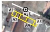
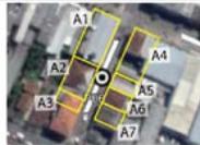
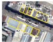
The next step involved the assessment of each evaluation location, into three environmental groups with four spatial categories. They are the private group, with the building category that verifies structure in the architectural elements (e.g., windows and elements attached to the facade); semi-public, which relates to the lot category that verifies structures present in the lot (e.g., trees, bushes, and walls); and public spaces, that has the sidewalk category (e.g., signs, trees, and benches) and the street category (e.g., if it has a linear perspective or if the road has curves that block the view) (Cozens & Love, 2015; 2017; Fennelly & Perry, 2018; Newman, 1972; 1996[1966]). Figure 1 provides a structured approach to collecting urban morphology data across spatial analytical groups and categories. This systematic approach for acquiring evaluation metrics was essential to classify distinct locations by their urban form characteristics.
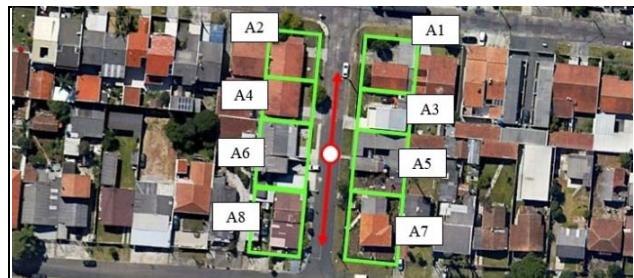
 Panel label: selected point.
 Panel label: grid.
 Panel label: grid code.
 Panel label: visual acuity.
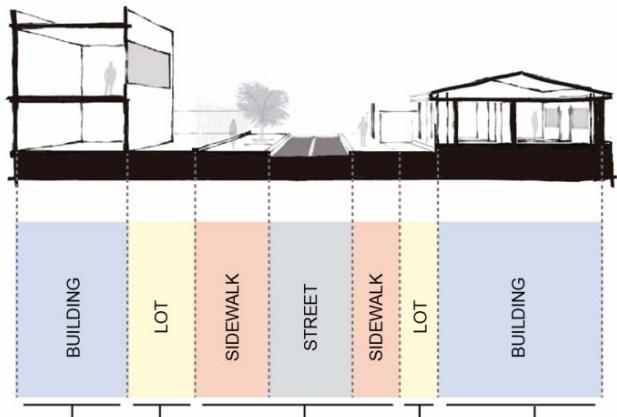 Figure 1: Schematic Representations of Division of Public Space into Units of Analysis for Evaluation of Landscape-Morphology Aspects (Left) and of Urban Space into Categories (Right) Panel label: PRIVATE. Panel label: SPACE. Panel label: SEMI-PUBLIC.
SPACE
PUBLIC
SPACE
SEMI-PUBLIC
SPACE
PRIVATE
SPACE
Sources: Based on Google Earth (2024) and principles reported by Cozens & Love (2015; 2017), Fennelly & Perry (2018), Gehl (2010) and Newman (1972; 1996[1966]).
Because the objects of study are explicitly interpreted by the landscape morphology of areas of community use, the spatial division proposed by Newman (1972; 1996[1966]) was adapted, merging semi-public and privative categories into one (private space), since the only effect considered is the morphological aspect of the external environment, in this case, the building facade. It is worth mentioning that the initial study by that author was developed in housing complexes, where transitional locations are relevant because the spaces in front of the residences (apartments) serve as reception and horizontal and vertical circulation, ordinary in that context. Therefore, the theory is socio-geographically adapted for the case study. This approach was used to promote observations coherent with the study aim, based on hierarchies of defensible space.
Environmental metrics related to the perspective of natural surveillance were developed through multiple stages. First, Brazilian work conditions guidelines were used to determine parameters for walkable sidewalks or the ideal height for visual blocking elements. Additionally, when those standards were not available, supplementary measurements relied on other sources.
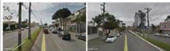
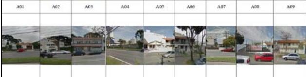
Aerial and oblique images from Google Earth (2024) and Google Street View (2024) were used to identify landscape-morphology elements, following Bondaruk's (2016[2007]) assessments of those that foster crime and other references that mention morphological parameters. The imaging analysis involved indicating the existence or absence of certain components.
A comparative relationship with the human scale was established as an approximation parameter for minimum and maximum evaluations of specific conditions. This analysis model was chosen due to the need to develop remotely applicable experimentation procedures, given the economical and practical nature of the test methodology. The criteria for analyzing components of the public space according to spatial categories for evaluating the landscape-morphology aspects of the selected points are summarized in the valuation system shown in Table 1.
Table 1: System of Evaluation of Components According to Spatial Categories of the Landscape-Morphology Aspects of Selected Points
<table><tr><td>Space</td><td>Criteria and Justification</td><td>Specific Parameter</td><td>Unit of Measure (Reference Limits)</td><td>Grade</td><td>Final Score</td></tr><tr><td colspan="6">Public Spaces</td></tr><tr><td rowspan="2">Street</td><td>Visual Cone: Sudden angulation of the street interferes with the continuity of its visualization (Bondaruk, 2016[2007]).</td><td>When the axis of the studied street has inclination or curvature before the 25 m defined from each point in opposite directions (visual acuity - Gehr, 2010), the rating is cancelled by the character of vision blocking (Bondaruk, 2016[2007]).</td><td>Slope or curvature within 25 m of visual distance: absence = 2.00 presence = 0.00</td><td>0.00 or 2.00</td><td rowspan="2">4.00</td></tr><tr><td>Street Shape: Characteristic of bridge, viaduct, ditches, underground passages, or the like, without exit or small size, among others, generating areas of low visibility and conducive to illicit acts (Mascaró, 2005[2003]).</td><td>Several morphological characteristics of streets are detrimental to proper occupation of the street (Bondaruk, 2016[2007]). The ideal bordering dimensions for urban axis streets are: minimum width of 5 m (Brasil, 1979) and blocks with a maximum length of 100 m (Mascaró, 2005[2003]). Exclusively pedestrian streets provide natural surveillance (Jacobs, 2011 [1961]), which qualifies this configuration as positive.</td><td>Existence of any of the characteristics mentioned: positive = 2.00 negative = 0.00</td><td>0.00 or 2.00</td></tr><tr><td rowspan="4">Sidewalk</td><td>Ground Irregularities: These surface characteristics of pedestrian areas reduce the flow of people (Bondaruk, 2016[2007]). In contrast, fluidity of human movement adds to natural vigilance (ATR, 2014).</td><td>According to criteria standardized by the Brazilian Association of Technical Standards (ABNT, 2020[1994]), sidewalks should have no steps or obstructions nor any conditions causing falls. Certain types of paving with irregularities (e.g., stone blocks, among others) are considered not to prevent fluidity of pedestrian movement.</td><td>Any type of irregularity makes walking difficult: absence = 2.00 presence = 0.00 Sidewalk parallel to the street: absence = 0.00</td><td>0.00 or 2.00</td><td rowspan="4">8.00</td></tr><tr><td>Dimensions: Reduced sidewalk widths make it difficult for people to pass, including obstacles to pedestrian movement (Bondaruk, 2016[2007]).</td><td>The minimum dimension for sidewalk width is 1 m, with an ideal of t 1.20 m (ABNT, 2020[1994]).</td><td>Width size of free sidewalk: greater than 1 m = 2.00 less than 1 m or ride non-existence = 0.00</td><td>0.00 or 2.00</td></tr><tr><td>Visual Obstruction Element: Any physical structures that cause visual blockage to the passerby (Fennelly; Perry, 2018).</td><td>If you have any visual obstruction element measuring 0.90 m in height and 0.70 m in width (Fennelly; Perry, 2018).</td><td>Presence of some physical element of visual blockage: non-existence = score of 2.00 existence = score of 0.00 Ephemeral elements (e.g., buildings, buckets) = score of 0.00</td><td>0.00 or 2.00</td></tr><tr><td>Permanence Furniture: physical elements that lead to the permanence of people on site (Bondaruk, 2016 [2007]).</td><td>Presence of furniture (Bondaruk, 2016 [2007]).</td><td>Any type of urban furniture that allows permanence: presence = 2.00 absence = 0.00</td><td>0.00 or 2.00</td></tr><tr><td colspan="6">Semi-Public Spaces</td></tr><tr><td>LOT</td><td>Physical Element: fences in or near building alignment (such as walls, for example) prevent intervisibility between public and private spaces (Bondaruk, 2016[2007]).</td><td>The morphology of the dividing element between sidewalk space and lot maximizes visual permeability and prevents hidden areas (Bondaruk, 2016[2007]; Fennelly & Perry, 2018).</td><td>Transparent material or limited height: presence = 2.00 Grid or other elements relatively permeable to the view: presence = 1.00 Fenced front wall in building alignment = 0.00</td><td>0.00 or 1.00 or 2.00</td><td>4.00</td></tr><tr><td></td><td>Visual Barrier: Elements within the lot that prevent intervisibility are a hindrance to "eyes on the street" (Jacobs, 2011 [1961]).</td><td>Measures bordering the lot that partially or fully obstruct sight of the building facade: 0.90 m high (including vegetation) and above 2.40 m for tree branches (Fennelly & Perry, 2018).</td><td>Visual barrier: absence = 2.00 presence = 0.00</td><td>0.00 or 2.00</td><td></td></tr><tr><td colspan="6">Private Spaces</td></tr><tr><td rowspan="2">Building</td><td>Visibility Openings: Facade elements that allow visibility between the internal and external environment (Bondaruk, 2016[2007]).</td><td>Building and other elements should allow visual permeability of the external environment, especially views of the street, and vice versa (Fennelly & Perry, 2018).</td><td>Facade mostly of transparent material or open = 2.00 Facade with some windows = 1.00 Blind gable = 0.00</td><td>0.00 or 1.00 or 2.00</td><td rowspan="2">4.00</td></tr><tr><td>Visual Obstruction Elements: Fixed building components obstruct potential visual permeability (Bondaruk, 2016[2007]).</td><td>Static obstruction of visually permeable components, especially related to the visual clarity of the windows, identified as blocking line of sight (Bondaruk, 2016[2007]; Fennelly & Perry, 2018).</td><td>Visual obstruction: absence = 2,00 presence = 0.00</td><td>0.00 or 2.00</td></tr></table>
Previous tests for verifying the methodology discovered a lack of information and similar investigation of differentiation between categories of natural-surveillance morphology. Therefore, interviews were conducted using the Delphi Technique (Linstone & Turoff, 2002[1975]; Varndell et al., 2021) to define a weighting system for each aspect.
A straightforward analysis with fifteen urban management and security specialists was applied to define the category weightings. The questions aimed to identify morphology criteria that are relevant for visual permeability and natural surveillance concerning the incidence of crime in the public spaces (Jajoriya & Singh, 2023).
Each aspect was initially rated according to the respondent's assessment of importance, followed by an evaluation of the other requirements. Questionnaires were applied in person and on paper. The criteria were divided into four relevance categories: low, medium-low, medium-high, and high, corresponding to ratings from 1 to 4.
The weighting for the specific criterion was determined from the sum for each category, and its average was linked to the score for the criteria for the study point. Results from the Delphi Technique applied the weightings and potential variation of the variables according to the provisions of Table 2.
Table 2: Illustrative Scheme for Distribution of Criteria in the Specialists' Questionnaire for Proposing Weightings for Visual Permeability and Natural Surveillance
<table><tr><td>Space</td><td>Criteria</td><td>Grade</td><td>Weight</td><td>Low Potential</td><td>Medium-Low Potential</td><td>Medium-High Potential</td><td>High Potential</td></tr><tr><td rowspan="2">Street</td><td>Visual Cone</td><td>0,002,00</td><td>3,00*</td><td rowspan="2">0,00 – 3,00</td><td rowspan="2">3,01 – 6,00</td><td rowspan="2">6,01 – 9,00</td><td rowspan="2">9,01 – 12,00</td></tr><tr><td>Street Shape</td><td>0,002,00</td><td>3,00*</td></tr><tr><td rowspan="4">Sidewalk</td><td>Ground Irregularities</td><td>0,002,00</td><td>2,80*</td><td rowspan="4">0,00 – 7,30</td><td rowspan="4">7,31 – 14,60</td><td rowspan="4">14,61 – 21,90</td><td rowspan="4">21,91 – 29,20</td></tr><tr><td>Dimensions</td><td>0,002,00</td><td>3,20*</td></tr><tr><td>Visual Obstruction Element</td><td>0,002,00</td><td>3,50*</td></tr><tr><td>Permanence Furniture</td><td>0,002,00</td><td>5,10*</td></tr><tr><td rowspan="2">LOT</td><td>Physical Element</td><td>0,001,002,00</td><td>3,30*</td><td rowspan="2">0,00 – 3,20</td><td rowspan="2">3,21 – 6,40</td><td rowspan="2">6,41 – 9,60</td><td rowspan="2">9,61 – 12,80</td></tr><tr><td>Visual Barrier</td><td>0,002,00</td><td>3,10*</td></tr><tr><td rowspan="2">Building</td><td>Visibility Openings</td><td>0,001,002,00</td><td>4,80*</td><td rowspan="2">0,00 – 4,40</td><td rowspan="2">4,41 – 8,80</td><td rowspan="2">8,81 – 13,20</td><td rowspan="2">13,21 – 17,60</td></tr><tr><td>Visual Obstruction Element</td><td>0,002,00</td><td>4,00*</td></tr><tr><td colspan="4">Average Per Point</td><td>0,00 – 5,00</td><td>5,01 – 10,00</td><td>10,01 – 15,00</td><td>15,01 – 20,00</td></tr><tr><td colspan="4">Final Average</td><td>0,00 – 17,90</td><td>17,91 – 35,80</td><td>35,81 – 53,70</td><td>53,71 – 71,60</td></tr></table>
Finally, the results were obtained and spatialized, and the information critically gauged according to quantifications from the scores and patterns found, using a graph to summarize the relationships between ratings and crime figures for the place studied. This set of methodological procedures allows for the evaluation of the research findings.
## IV. ANALYTICAL RESULTS
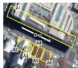
The municipality of São José dos Pinhais is in the Southern Region of Brazil and integrates the Metropolitan Region of Curitiba (Figure 2). According to population estimates, it is home to 345,644 inhabitants in a territory of $946.43\mathrm{km}^2$, approximately $10\%$ corresponding to its urbanized area (IBGE, 2024). Analysis locations were determined by mapping crime incidents in its central neighborhood, which was initially selected as the place with the highest incidence of public-space robbery and theft. Fourteen locations were selected based on the heat map with the number of incidents per location.
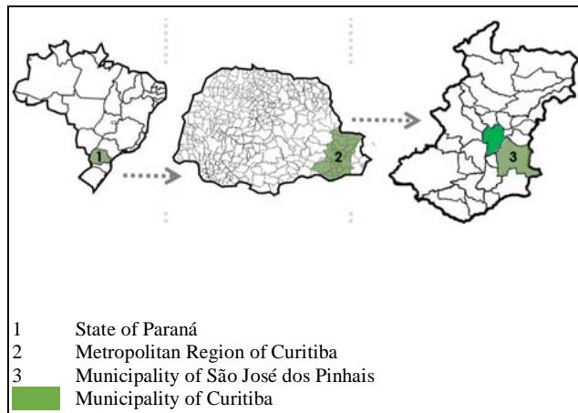
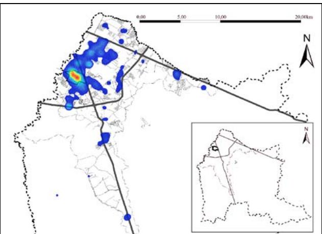
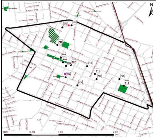
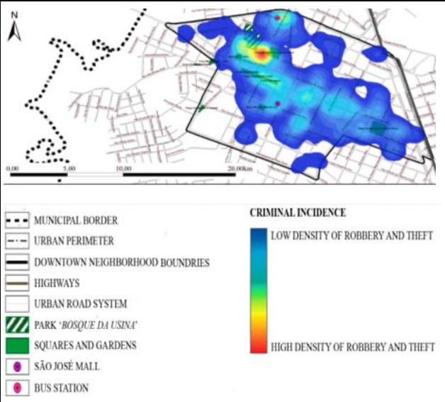 Figure 2: Maps of the Location of the Study Area (Top Left) and of the Crime Incidence in the City (Top Right) and in the Central Neighborhood of São José dos Pinhais (Bottom Right), and of the Selected Points of Robbery and Theft (Bottom Left)
Sources: Prepared from GM-SJP (2015-2018) and PM-SJP (2024).
Weightings for the landscape-morphology categories were determined from questionnaires based on the Delphi Technique, which separated criteria according to relevance. Figure 3 shows the raw and proportional numbers of these responses.
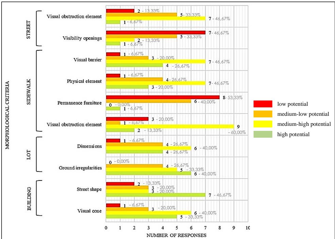 Figure 3: Quantitative and Proportionality Graph of Responses of Specialists from the Fields of Public Safety and Urban Management for Determining the Importance of Landscape-Morphology Variables
Source: Based on responses to the Delphi Technique questionnaire.
Permanence furniture on sidewalks and visibility openings in buildings achieved higher ratings. The most relevant results align directly with the main questions concerning natural surveillance, namely, the possibility of sight (morphological permeability) and the presence of individuals in public places with suitable furniture.
Both criteria conform to one of the most established theories in the field of urban studies, related to "eyes on the street" and the natural surveillance precepts of Jacobs (2011[1961]), considering that permanence furniture allows the effective presence of people and promotes indirect monitoring, while buildings with street-level openings enable interaction between the private and the public space.
The relevance of furniture may be associated with other interpretations that resemble natural surveillance but in different directions. Visibility openings, meaning elements of building permeability such as windows and doors, present clear possibilities for spontaneous monitoring (Amiri et al., 2019).
The criteria linked to visual obstruction elements of buildings, such as pillars and awnings, directly associated with visibility openings, are rated at medium-high to medium-low level, as they impede complete surveillance from the private environment. Physical boundary elements such as walls or railings are also noteworthy because, depending on configuration, extensive walled areas can create feelings of insecurity, often generating the "fortress effect". According to Bondaruk (2016[2007]), protection of private property through large walls preventing visual permeability to public spaces produces the opposite effect, encouraging crime due to an inability to monitor (Chen & Biljecki, 2023).
The other listed criteria are mainly rated between low and medium-low levels. Elements of visual obstruction on the sidewalk are rated medium-low, which pertains to any type of morphological barrier, such as bushes, signs, posts, or others obstructing complete visibility of the street (Fennelly & Perry, 2018). Street shape was predominantly categorized as low quality due to its line of sight and is less relevant to the context of this study. The weightings for each morphology criterion are identified in Table 3.
Table 3: Classification of Public Safety and Urban Management Specialists' Responses based on the Delphi Technique with Weightings for Landscape-Morphology Variables
<table><tr><td>Space</td><td>Criteria</td><td>Low Potential
(Weight = 1)</td><td>Medium-Low Potential
(Weight = 2)</td><td>Medium-High Potential
(Weight = 3)</td><td>High Potential
(Weight = 4)</td><td>Final Weight</td></tr><tr><td rowspan="2">Street</td><td>Visual cone</td><td>5,00</td><td>6,00</td><td>3,00</td><td>1,00</td><td>3,00</td></tr><tr><td>Street shape</td><td>7,00</td><td>3,00</td><td>3,00</td><td>2,00</td><td>3,00</td></tr><tr><td rowspan="4">Sidewalk</td><td>Ground irregularities</td><td>6,00</td><td>5,00</td><td>4,00</td><td>0,00</td><td>2,80</td></tr><tr><td>Dimensions</td><td>4,00</td><td>6,00</td><td>4,00</td><td>1,00</td><td>3,20</td></tr><tr><td>Visual obstruction element</td><td>2,00</td><td>9,00</td><td>1,00</td><td>3,00</td><td>3,50</td></tr><tr><td>Permanence furniture</td><td>1,00</td><td>0,00</td><td>6,00</td><td>8,00</td><td>5,10</td></tr><tr><td rowspan="2">LOT</td><td>Physical element</td><td>3,00</td><td>7,00</td><td>4,00</td><td>1,00</td><td>3,30</td></tr><tr><td>Visual barrier</td><td>4,00</td><td>7,00</td><td>3,00</td><td>1,00</td><td>3,10</td></tr><tr><td rowspan="2">Building</td><td>Visibility openings</td><td>1,00</td><td>2,00</td><td>5,00</td><td>7,00</td><td>4,80</td></tr><tr><td>Visual obstruction element</td><td>1,00</td><td>7,00</td><td>5,00</td><td>2,00</td><td>3,80</td></tr></table>
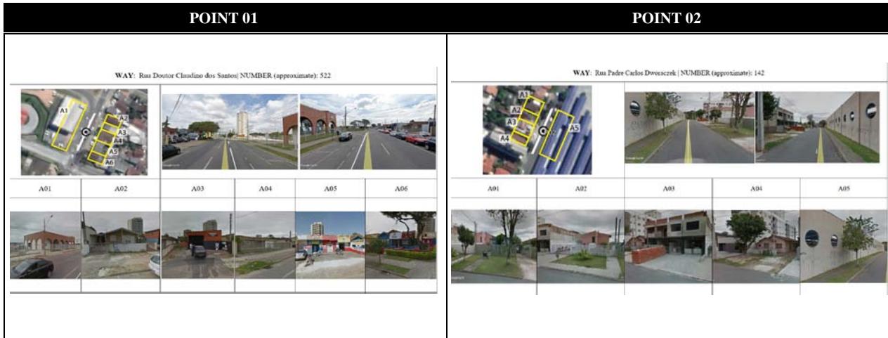
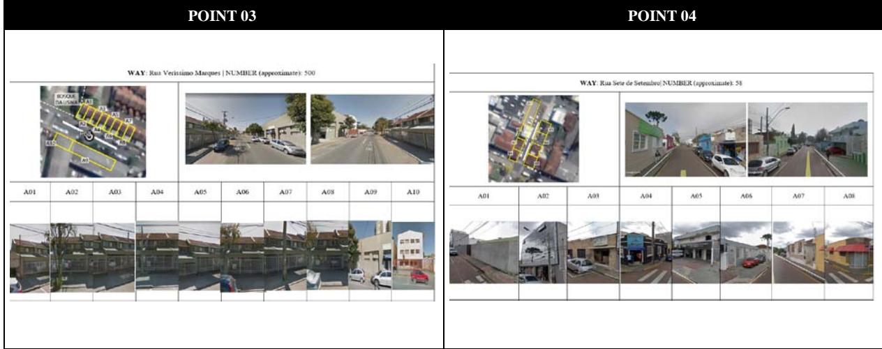
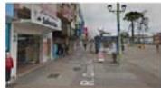
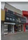
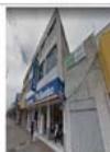
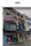
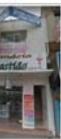
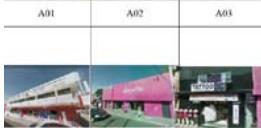
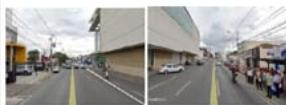
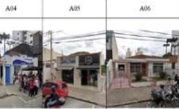
The quantity of crime incidents by point within the defined ranges is then related to mapping of crime types near the analysis points in terms of optical distance (25 m radius - Gehl, 2010) and standard block distance (100 m radius - Mascaró, 2005[2003]) (Figure 4). The synthesis of results for all landscape-morphology evaluation locations is presented in Table 4.
### POINT 05
WAY: Rua Quinze de Novembro [NUMBER (approximate): 1366
A01
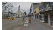
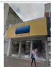
A05
#### POINT 06
WAY Rua Mendes Leiteo NUMBERR (approximane): 2530
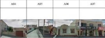
#### POINT 07
WAY:Rua Quinze de Novembre NUMBER (approximate):1525
<table><tr><td>A01</td><td>A02</td><td>A03</td><td>A04</td><td>A05</td><td>A06</td><td>A07</td><td>A08</td><td>A09</td></tr><tr><td></td><td></td><td></td><td></td><td></td><td></td><td></td><td></td><td></td></tr></table>
#### POINT 08
WAY: Rua Voluntarios da Pitrisa NUMBER (approximate): 232
#### POINT 09
WAY:Avenda rui Barbosa NUMBERR (approximate):9430
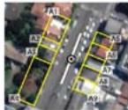
#### POINT 10
WAY: Avenida Rm Barbosa NUMBERR (approximate): 9122
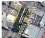
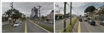
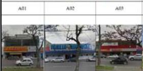
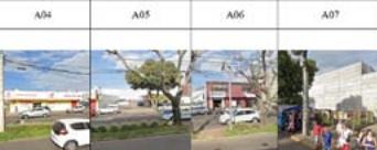
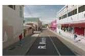
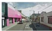
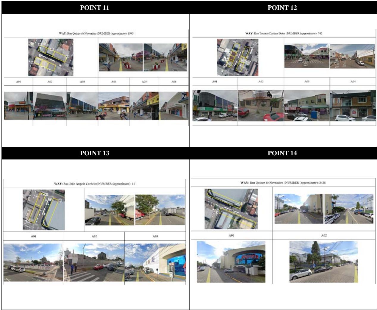 Figure 4: Maps of Theft and Robbery and Aerial and Oblique Images of the Analysis Points
Sources: Based on Google Earth (2024), Google Street View (2024), GM-SJP (2015-2018) and PM-SJP (2024).
Table 4: General Values Attributed to Analysis Points According to Spaces for Landscape-Morphology Assessment
Legend:
<table><tr><td rowspan="2">Point</td><td colspan="4">Space</td><td rowspan="2">Final Grade</td></tr><tr><td>Street</td><td>Sidewalk</td><td>LOT</td><td>Building</td></tr><tr><td>P01</td><td>12,00</td><td>16,90</td><td>6,95</td><td>6,80</td><td>42,65</td></tr><tr><td>P02</td><td>12,00</td><td>11,40</td><td>2,60</td><td>10,88</td><td>36,88</td></tr><tr><td>P03</td><td>12,00</td><td>15,50</td><td>8,55</td><td>11,52</td><td>47,57</td></tr><tr><td>P04</td><td>12,00</td><td>13,33</td><td>10,79</td><td>11,40</td><td>47,51</td></tr><tr><td>P05</td><td>12,00</td><td>22,23</td><td>0,00</td><td>17,60</td><td>51,92</td></tr><tr><td>P06</td><td>12,00</td><td>16,26</td><td>1,83</td><td>13,71</td><td>43,80</td></tr><tr><td>P07</td><td>12,00</td><td>29,20</td><td>0,00</td><td>16,53</td><td>57,73</td></tr><tr><td>P08</td><td>12,00</td><td>13,17</td><td>10,18</td><td>12,80</td><td>48,15</td></tr><tr><td>P09</td><td>12,00</td><td>14,33</td><td>6,06</td><td>6,76</td><td>39,14</td></tr><tr><td>P10</td><td>12,00</td><td>17,00</td><td>11,86</td><td>9,14</td><td>50,00</td></tr><tr><td>P11</td><td>12,00</td><td>21,23</td><td>12,80</td><td>14,40</td><td>60,43</td></tr><tr><td>P12</td><td>12,00</td><td>19,00</td><td>0,83</td><td>14,00</td><td>45,83</td></tr><tr><td>P13</td><td>12,00</td><td>14,33</td><td>7,43</td><td>4,27</td><td>38,03</td></tr><tr><td>P14</td><td>12,00</td><td>19,00</td><td>9,60</td><td>8,40</td><td>49,00</td></tr><tr><td>Average</td><td>12,00</td><td>17,35</td><td>6,39</td><td>11,30</td><td>47,05</td></tr></table>
$$
= high potential
$$
$$
= medium-high potential
$$
$$
= medium-low potential
$$
$=$ low potential
The final grade ratings are generally stable in higher quality ranges (medium-high and high), with a minimum value of 36.88 and a maximum of 60.43, referring to the highest-ranking regarding safety and landscape-morphology characteristics. In other words, the results indicate the opportunities for natural surveillance on the violent streets evaluated, suggesting that, in theory, they should not have such high crime rates. This situation is supported by Figure 5, which lists the crime position for each point with respective valuations.
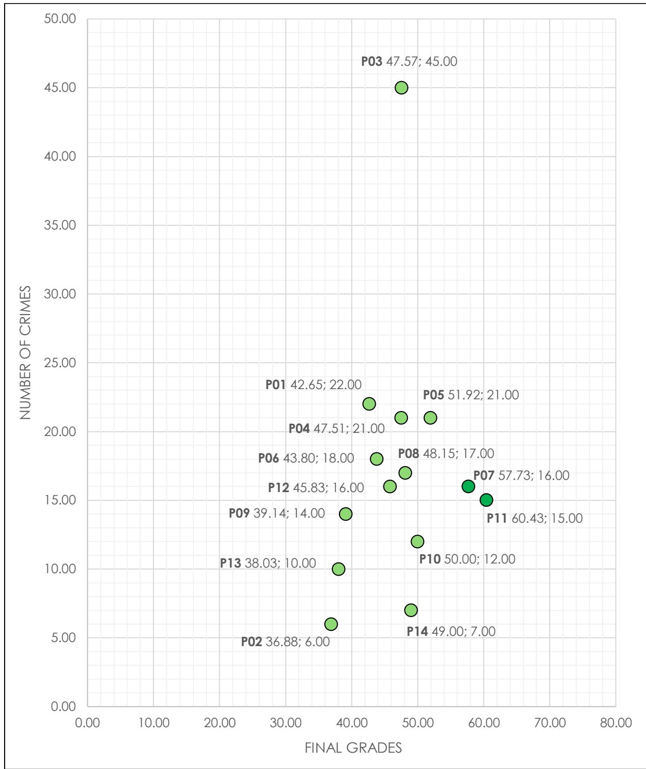
Source: Based on the Specific Results of the Places. Figure 5: Dispersion Graph of the General Levels of Landscape-Morphology Evaluation Ratings for the Analysis Points in Relation to Crime Position
- $\bullet$ = high quality
- medium-high quality
The graph can be interpreted to show that the discrepancy of crime incidence, as seen in previous items, prevents establishment of a clear relationship between ratings and crime numbers. The places with the worst ratings (P07 and P11) indicate an agglomeration between 15 and 16 records, but without allowing verification of a clear pattern.
The variation of medium-high level between 6 and 22 crimes at almost every place, except P03 (with 45 incidents), is a mismatch within the study. The results demonstrate that, when focusing only on aspects of visual permeability and natural surveillance based on the established methodological options, the morphology of the central neighborhood is conducive to safety, despite being understood as a hazardous area within São José dos Pinhais.
Some considerations can be made about these findings. Firstly, regarding the aspects mentioned, the characteristics do not fully reflect the incidence of crimes of opportunity in the central neighborhood of the city analyzed. Although there is an emphasis on theory and practice linked to landscape morphology and criminality occurrence (Bondaruk, 2016[2007]; Cozens & Love, 2015; 2017; Jacobs, 2011[1961]; Wikström & Kroneberg, 2022), the results indicate that visual aspects are less important in the general context of safety.
Crime itself occurs due to a combination of socioeconomic and cultural conditions (Pavoni & Tulumello, 2018; Ribeiro & Morais, 2021), including the urban form. However, these findings primarily suggest that the elements affecting visual capacity and natural surveillance may not fully account for the relationships between criminal incidence and spatial structure, at least in the case of the central area of São José dos Pinhais.
The morphological approach needs to be considered from other scenarios defined by the theories of defensible space and CPTED to flow and access restriction, territorial reinforcement, site maintenance, aesthetic conditions, potential use, and geographical situation (Cozens & Love, 2015; 2017; Fennely & Perry, 2018; Heath-Kelly & Shanaah, 2022; Lynch & Barrett, 2017), rather than focusing on individual elements. It is also important to point out that the evaluation techniques could have been directed differently, given the employment of digital platforms and categorization of natural surveillance aspects (Jajoriya & Singh, 2023).
Methodological changes should be incorporated in future investigations related to the interpretation of criminality as a multifaceted theme. A deeper analysis of the dynamics between morphology and safety is needed, as well as other spatial characteristics, such as maintenance and state of conservation of places, forms associated with ergonomics, public and private lighting, and socioeconomic aspects.
It is also necessary to consider that the methods, techniques, precepts, and concepts from CPTED and defensible space used in this study were developed and applied in countries of Anglo-Saxon background. Therefore, they are based on sociocultural processes that are different from those of Brazil. Even so, the research findings lead to relevant final reflections.
## V. CONCLUSION
The study found that property crime rates remained high despite favorable morphological conditions for natural surveillance and visual permeability in the city center. In conclusion, these findings suggest that natural surveillance alone does not account for the elevated incidence of street thefts and robberies, highlighting the need for a holistic framework considering socioeconomic, cultural, and spatial factors. When dealing with CPTED and defensible space, previously mentioned elements (e.g., territoriality, access control, image and maintenance, activity support, target hardening, geographical juxtaposition), future research should consider a comprehensive evaluation aligned with the theory's postulates when defining a conceptual framework.
This research generated an evaluation methodology based on urban landscape morphology and crime prevention theories, stressing natural surveillance through visual aspects. It is noteworthy that even with the application of specific weightings to the criteria analyzed, defined by consulting specialists in the fields of urban studies and public safety, no significant relationship was found between lower-rated levels of landscape morphology conditions and areas with higher incidences of crime.
This result was not expected, because, according to environmental criminology theories, the possibility for more natural surveillance is indicative of, potentially, fewer offenses. Previous research did not account for visual aspects solely analyzed, although it emphasizes that crime prevention elements should be verified together. These results could be interpreted in two diverse ways, or as a statement that CPTED measures should be verified together, or that the findings imply that natural surveillance potential has a minor role in preventing crime.
Urban and security policymakers need to recognize the importance of a holistic approach to crime, integrating socioeconomic alternatives with urban landscape spatial projects to enhance the overall quality of life. Nevertheless, it was possible to evaluate morphological aspects of the urban landscape related to crime incidence, specifically theft, and robbery, supported by a case study applied to the central neighborhood of the municipality of São José dos Pinhais. The achievement of this goal was made feasible by the definition of the conceptual framework and the determination of the methodological procedures in the format of an essayistic investigation.
The interpretation of the analytical results reveals that it is impossible to diagnose clear associative parameters of visual permeability and natural surveillance of the studied places. Even so, the lack of relationships between violence indices and morphological patterns also cannot necessarily be confirmed, because the established criteria and adopted approaches may have restricted the findings regarding the safety potential associated with morphology.
The investigated areas are rated medium-high and high quality for security capacity, which does not conform to their crime rates, considering the principles of defensible spaces and CPTED. These precepts are more consistent with the contexts of countries of Anglo-Saxon origin. Then, a comparison with other landscape-morphology references for investigations in the Brazilian and Global South context is recommended. Such adaptations should consider the history of the area's urban development, natural, and topographical conformation, the cultural setting in terms of living behavior and criminal dynamics, and an understanding of local economics future.
Regarding the criminal incidence in urban spaces, the research question produces broad and generic answers. In this context, possible directions for future studies include the investigation of morphology in terms of other criminal typologies. It is also suggested to use broader and more multidisciplinary methodological techniques related to landscape form, which may or may not be performed remotely from aerial and oblique images. Likewise, it is an exploratory attempt to select and measure the importance of different morphological criteria in crime occurrence. Upcoming research could benefit from comparison case studies between known and unknown circumstances.
Other methods could be implied, or quantitative, such as the use of GIS, remote sensing, and AI analysis for large sets of data for expanding alternatives of obtaining relations and correlations, and qualitative, such as the use of surveys of ethnographical research to understand individuals' nuance and perceiving space. An alternative investigation would involve associating different regions of a city, or other urban areas, with urban morphology and criminal incidence. This would aim to expand theory and practice as support for the design, planning, and management of safe landscapes in cities.
## ACKNOWLEDGEMENTS
To Coordenação de Aperfeçoamento de Pessoal de Nível Superior (CAPES), for a doctoral scholarship to the first author. To Conselho Nacional de Desenvolvimento Científico e Tecnológico (CNPq), Fundação Araucária de Apoio ao Desenvolvimento Científico e Tecnológico do Estado do Paraná (FA), and Pontificia Universidade Católica do Paraná (PUCPR) for supporting the development of the research.
Generating HTML Viewer...
Funding
No external funding was declared for this work.
Conflict of Interest
The authors declare no conflict of interest.
Ethical Approval
No ethics committee approval was required for this article type.
Data Availability
Not applicable for this article.
Victor Augusto Bosquilia Abade. 2026. \u201cSafe Landscape: Evaluating Crime Prevention through Urban Morphology and Natural Surveillance Metrics\u201d. Global Journal of Human-Social Science - B: Geography, Environmental Science & Disaster Management GJHSS-B Volume 24 (GJHSS Volume 24 Issue B4): .
Urban morphological dynamics play a leading role in influencing the occurrence of criminal activities. The spatial configuration of public spaces can either amplify or mitigate the incidence of offenses in specific locations, as well as impact perceptions of insecurity and fear. Within the context of Brazilian cities, the rise in crime generates significant harm, affecting various sectors of society. Therefore, the objective is to evaluate urban landscape morphology and visual dynamics related to crime incidence in the central neighborhood of the municipality of São José dos Pinhais, Paraná, Brazil. Using a mixedmethod approach, criminal data was geocoded through heat maps to identify urban spaces for analysis. The evaluation procedures, grounded solely in crime prevention through environmental design (CPTED) and defensible space principles of natural surveillance, were developed to assess Google Street View images. The Delphi Technique was applied to establish the weighting of criteria related to visual permeability. Spatialization and critical assessment of results were followed. The study found that despite favorable morphological conditions for natural surveillance and visual permeability in the city center, crime rates remained high.
Our website is actively being updated, and changes may occur frequently. Please clear your browser cache if needed. For feedback or error reporting, please email [email protected]
×
This Page is Under Development
We are currently updating this article page for a better experience.
Thank you for connecting with us. We will respond to you shortly.