The newly discovered Hainan fisherman Zheng Changmei’s copy of the South China Sea ‘ Liushui Genglubu ‘ is divided into two parts : ‘ Liushui Record ‘ and ‘ Mountain Water Potential Map ‘. It is the only complete graphic-text combination of the South China Sea ‘ Genglubu ‘ found so far. This book records the tide situation in the western sea area of Hainan Island, the route around Hainan Island, the route distance from Hainan Island to Guangdong province, Guangxi province of China, Vietnam and other places, and 24 ‘ mountain water potential diagram ‘. The discovery of this book proves the use of ‘ Genglubu ‘ by merchant ships in Hainan Island; the 24 sea charts are the continuation and development of the rare mountain shape and water potential maps in the literature of the past dynasties. The drawing of the mountain shape and water potential has the characteristics of integrity, which makes up for the rare sea charts in the ‘ Genglubu ‘ of the South China Sea.
## I. INTRODUCTION
Genglubu is a navigation guide written by Hainan people to and from the South China Sea islands, the surrounding waters of Hainan Province, and Southeast Asian countries. It records in detail the name, location, needle position (heading), number and characteristics of islands and reefs in the South China Sea Islands and the surrounding waters of Hainan Province. It is a summary of the experience and collective wisdom of Hainan fishermen living, producing, developing and trading in the South China Sea Islands. In 2008, it was selected into the second batch of national intangible cultural heritage list. In the 1970s, when archaeologists conducted research in Qionghai, Hainan, 'Genglubu' was first known and valued by the academic community, causing research departments and scholars to collect, collate and study ' (Nanwei Liu, Zhengsheng Zhang, 2015). After more than 40 years of efforts by experts and scholars, at present, ' Genglubu ' has changed from the ' Nanhai Tianshu ' that can be understood by old fishermen and old captains to the ' Nanhai Encyclopedia ' today (Chongmin Wang, Genqi Yan, Liang Liu, 2018), and to a certain extent, ' Genglubu Study ' has been formed.
There are many records about ancient sea charts in ancient texts. Gong Zhen, who followed Zheng He to the Western Ocean, once described the importance of sea charts: 'When sailing, we rely on the navigation compass, the navigation guide book and the navigation chart to guide the navigation. This process must be carefully and carefully, and cannot be ignored.' Cheng Shun of Ryukyu also has a similar record in the 'guide broad sense'. The book writes that 'from the navigation tool books and maps given by the people who previously sealed the boats and steered.... Can be found that under the sky, on the ground, all the obvious and not easy to find, are recorded in it, 'the book also pointed out that ' there are many pictures and pages in the ancient books,... The mountain and water potential in the navigation route are drawn according to the shape, so as to prepare for the future navigation investigation. After many investigations, Mr. Liu Yijie (2015) pointed out that in the ancient sailing period of China, the positioning and safe navigation of ships were mainly based on needle scripts and ' schema '. This schema refers to the ancient nautical chart, mainly to describe the mountain shape, water potential, so the ancients vividly named it 'mountain shape water potential map'. Unfortunately, this ' schema ', It's very rare now, so it makes all kinds of needle road book has been repeatedly mentioned but not seen in the mountain water potential figure, is particularly important.
Although all kinds of needle road books have repeatedly mentioned the mountain water potential map, But unfortunately there is no literature about it. During the author's investigation in Yinggehai, Ledong, Hainan in 2019, author found Zheng Changmei's copy of ' Liushui Genglubu '.[^1] In addition to recording nautical routes and flowing water records, there are also 24 very precious nautical charts. It is a relatively complete ' Genglubu ' of ' combination of pictures and texts ' found at present. It can also be regarded as an extension of ancient ' mountain shape and water potential map ' in modern times.
## II. A BASIC SURVEY OF ZHENG CHANGMEI'S COPY OF LIUSHUI GENGLUBU
Zheng Changmei's copy of 'Liushui Genglubu' was copied in October 1980, which was written on a notebook in the order of ancient binding and writing. The whole book is written in vertical rows, from top to bottom, from right to left, and on the right side, which can be divided into two parts. The previous part, from page 1 to page 14, is writing with a brush, divided into: 'Six Collision Flow Methods', 'look at the timetable with running water', which records the tide rising and ebbing. This part is separated from the latter part by two blank papers. In the latter part, the page number is renumbered separately. From page 1 to page 30, it records the voyages, routes and ports between Hainan, Guangdong, Guangxi and Vietnam. The most important thing of this book is that there are 24 charts that are consistent with the written records. This article will focus on these charts later.
### a) The ' Six Collision Flow Methods ' of the western flow record
Although many versions of 'Genglubu' have been found, most of them have 'flow meter', that is, the record of tide rising and ebbing; however, compared with other versions, Zheng Changmei's copy of Liushui Genglubu has a unique record of 'Six Collision Flow Methods'. On the first page of the book, it is neatly recorded with a brush:
Six Collision Flow Methods
Xu Chen collided: January, July, the eleventh day, the twenty-five day.
You Mao collided: February, August, the seventh day, the twenty-first day.
Shen Yin collided: March, September, the fourth day, the eighteenth day.
Wei Chou collided: April, October, the first day, the fifteenth day, the twenty-ninth day.
Wu Zi collided: May, November, the thirteenth day, the twenty-seventh day.
Yi Hai collided: June, December, the eleventh day, the twenty-fifth day.
The 'Six Collision Flow Methods' is a unique feature of this book. This book adopts the theory of China's twelve hours collide with each other and summarizes the water situation in the area. According to the local Mr. Chen and Mr. Wang (They are the author's interview subjects), Hainan Yinggehai fishermen fishing operations, mostly in the vicinity of the sea to do the sea, so the local record of running water flow meter, for them is particularly important. These water records, which can be traced back to the Tongzhi period of the Qing Dynasty, are closely related to Mr. Ke Hongmo, the pioneer of Yinggehai culture. Ke Hongmo, born in
Xianfeng Renzi year, died in Guangxu Dingyou year. He founded the first private school in Yinggehai and cultivated a large number of excellent students. The 'liushui record' is that Ke Hongmo, with the help of his proud students Fang Dinghua, Yu Faxing, Wu Wenqing and others, has spent a long time exploring the sea with his clever wisdom, summed up the law of the tidal flow in Yinggehai, and recorded it in writing as 'the monthly tidal flow schedule in Yinggehai'. This statement remains to be further confirmed.
### b) The Genglubu of Hainan round-island
The second half of the book mainly records the combination of text and image. From page 1 to page 21, the main record is from Haikou, Hainan Island, along the west coast of Hainan Island, all the way west, to Sanya, and then along the east coast of Hainan Province, and finally to Haikou. The route detailed records the route from Haikou, the northernmost port of Hainan Province, to Haikou-Chengmai-Linggao-Dan zhou-Changjiang-East-Ledong-Sanya-Lingshui-Wanning -Qionghai-Wenchang-Haikou on the way. This route completely records all the cities and counties in the eastern and western coastal cities of Hainan Province. It is a very rare round-island route change.
Some versions found at present also have records of local routes in Hainan Province, such as the 'Genglubu' of Liang Qingguang. Among it has 'Records of the North Mountains and Rivers under Jiangmen', 'Look at the water program under the Libian West Road in Qiongnan', Wang Shitao's version of 'Genglubu' has 'Records of Qiongzhou's Sailing Routes around Hainan Province, 'Wu Daoxiong's version of Come and Go Smoothly' has 'From Tanmen Port to Xiageng Road', 'From Tanmen Port to Shanghai Port Geng Road' and other routes in Hainan Province. However, most of these versions of the routes are recorded from Tanmen Port in Hainan, and most of the routes are part of Hainan Province. It is very rare for Zheng Changmei's copy to record the route from Haikou to the west, through Sanya, the south ernmost port of Hainan Province, north along the east coast, and finally to Haikou.
### c) Routes centered on Fushuizhou, Vietnam
The page 22 of this book is a single page of written records. It uses a brush to neatly copy the route centered on Fushuizhou, and records the routes and voyages from Fushuizhou to Hainan, Guangxi and Hainan to important ports in Guangdong. The word 'Jia' appears below represents the support, which is the way local fishermen in Hainan use the compass. The word 'Jia' is followed by the Tiangan Dizhi in Chinese, indicating the location. 'geng' means the length distance, one is about 10 to 12 nautical miles:
Fushuizhou to the Lingaojiao, Jia Mao You Yi Xin Chen Xu, twelve geng arrive;
Fushuizhou to the Bingmajiao, Jia Yi Xin Chen Xu, nine geng arrive;
Fushuizhou to the Jiangongjiao, Jia Yi Xin Chen Xu, eight geng arrive;
Fushuizhou to the Guanyinjiao, Jia Yi Xin Chen Xu, seven geng arrive;
Fushuizhou to the Haitou, Jia Yi Xin Chen Xu, seven geng arrive;
Fushuizhou to the Haiwei, Jia Chen Xu, seven geng arrive;
Fushuizhou to the Changhuajiao, Jia Qian Xun Chen Xu, seven geng arrive;
Fushuizhou to the Sigengshawei, Jia Qian Xun, seven geng arrive;
Fushuizhou to the Weizhou, Jia Gen Kun Yin Shen, ten geng arrive;
Fushuizhou to the Qinzhou, Jia Yi Hai, three geng arrive.
Fushuizhou Island is located in the Beibuwan, $20^{\circ}01$ north latitude and $107^{\circ}42$ east longitude. It is 70 nautical miles from Basuo Port in Hainan Province of China in the southeast and Haiphong Port in Vietnam in the northwest. Nightingale Island is the title of the island in official books since the Ming and Qing Dynasties, even in the Republic of China and the early days of the founding of the People's Republic of China. Bailongwei Island was named by the former French Indochina colonial authorities when they invaded the island in the 1930s. Fishermen and coastal residents in Guangxi, Guangdong and Hainan in China call it Fushuizhou Island, because it is always in the view of Chinese fishermen, whether it is wind, rain, fog, or the sun and moon(Dechao Li, 1996).
The offshore of Fushuizhou Island is a broad reef bottom shallow sea, which is a famous abalone and sea cucumber habitat. The island's shallow sea, rich in red fish, squid, grouper, is a rich trawl fishing ground. Historically, fishermen in Chaozhou, Guangdong, Danzhou and Wenchang County, Hainan have always used the island as a base for abalone production. According to relevant literature, the history of modern Chinese people settling on the island has been reliable for more than a hundred years. When the island was liberated in 1955, it was found that there were temples dedicated to Tianfei Niangniang and General Fubo on the island. There was also an iron clock cast by Fu Jianming and Fu Huaiji in Wenchang, Hainan in the third year of Guangxu (1877).
The route of this page records the routes from Fushuizhou to Lingaojiao, Bingmajiao, Jiangongjiao, Guanyinjiao, Haitou, Haiwei, Changhuajiao, Sigengshawei in Hainan Province, and to Weizhou and Qinzhou in Guangxi Zhuang Autonomous Region, indicating that Chinese fishermen are familiar with the port.
### d) Precious 24 charts
China has a long history of navigation, but, 'about before the invention of the navigation compass, there is no chart ' (Yijie Liu, 2015). About the Southern Song Dynasty, the Chinese literature began to draw a chart with a sea route called ' sea route map'. These nautical charts connect the states and counties through which the route passes to form ' nautical lanes', and plot the islands with the nature of Wangshan through the route in the corresponding position. Some important segments will also mark the special hydrological conditions of the sea area, such as ' The waves are white, the spray is like snow, see this situation need to avoid in time'. However, unfortunately, although there are records of nautical charts in many documents, the nautical charts handed down are relatively rare.
Zheng Changmei's copy of 'Liushui Genglubu' has a total of 24 charts, located in two places. One is from page 1 to page 21, that is, the Genglu around the island of Hainan Province. Each page has corresponding chart drawing at the recorded Genglu. The other is page 23 to page 25. These three charts have no written records, only graphic drawing. They mainly draw important ports in Hainan, Guangdong, Guangxi and other places, needle position, route, voyage, mountain shape and water potential, etc. This article will be discussed in detail later.
In addition, the "Liushui Genglubu" also "see the timetable with water," written records of " from Jiangmen to Beishan Waterway " and " from Jiangmen to Huashan Waterway Record " and other route voyages.
## III. THE TEXT FEATURES OF ZHENG
### CHANGMEI'S COPY OF LIUSHUI GENGLABU
Zheng Changmei 's copy of ' Liushui Genglubu ' has some unique text features in both text content and writing form. This paper briefly analyzes the following:
### a) Traces of repeated copying and modification
Although the 'Liushui Genglubu' has obvious marks on the cover: in October 1980, Zheng Changmei copied it. However, throughout the book, it can be seen that the book retains the traces of multiple transcriptions. For example, the first part, from page 1 to page 14, all written in brush words. This part mainly records the 'Six Collision Flow Methods' and 'timetable with running water'. The latter part is separated from the previous part of the water record by two white papers; the latter part, from page 1 to page 21, text and pictures, are all copied and drawn with blue ballpoint pen; on page 22, it is written in brush strokes; from page 23 to page 25 of the three pictures, and into the brush strokes; page 26 to page 29, turned into blue pen and black pen alternately. It can be seen that this book was copied by Zheng Changmei many times. There are also several obvious transcription errors in the book. These indicate that Zheng Changmei has not been to these places in person, He's just a copyist. But where did he copy? Further research is needed.
### b) The historicity and comprehensiveness of the text formation age
At present, there is no doubt that this Liushui Genglubu was copied by Zheng Changmei in October 1980. However, through careful study of its content, it can be seen that the original copy may not only, but also a combination of the long-term records of the fishermen in the history of the area and other 'Genglubu', and on this basis, it has been modified and added some content. For example, the first page of the 'see the schedule with running water': 'Mao: five to six o'clock in the morning: rabbit. Chen: seven to eight o'clock in the morning: dragon..... Yin: three to four o'clock at the night: tiger, etc. These time records, combined with the ancient phase, time and modern time clock records, can be more convenient to use clocks to record water time.
### c) The recording method of graphic-text combination
The very important feature of the "Liushui Genglubu" is its combination of graphics and text, which is very rare in other versions of the "Genglubu." In the roundabout route of Hainan Province, there are corresponding charts under each written record. The routes in these charts are composed of needle positions and mileages, and are marked with ports, islands, peaks, water potentials, reefs, dark sands, and fishing operations along the coast. It can be said that these charts are a development of ancient Chinese nautical charts, and can also be seen as an extension of mountain water potential charts in modern times.
### d) Complete Hainan round-island's Routes
At present, most of the 'Genglubu' departure ports are Tanmen Port in Qionghai City, Hainan Province. This version of the route in Hainan Province is a very complete roundabout route starting from Haikou, the northern port of Hainan Province, passing through the western port, the southern port, the eastern port, and finally reaching Haikou. This part of the road records about 90 roads and 90 ports, which provides very important information and value for the study of Hainan's ports, fishery resources, geological water quality, maritime traffic, and private trade.
e) Its background is related to the prosperous commercial trade in Yinggehai, Ledong County, Hainan Province
According to the author's research, Yinggehai people's fishing operations are mostly in the offshore area; fishery trade is to sail around the island, or from Hainan to Guangdong, Guangxi, Vietnam and other places. 'Yinggehai Zhi' records the prosperous commercial trade of Yinggehai. According to the records of 'Yinggehai Zhi', in the 25th year of Qianlong in the Qing Dynasty, the business firms of Fang's Zhi Qigong in Xin'an Village, Baishabu, Haikou moved to Yinggehai, and soon the business firms of Wang Yinggong in Daojun Village, Qiongshan County moved to Yinggehai. These commercial ports mainly engaged in shipbuilding oil, lime, fine linen, hemp, cotton yarn, etc., and also purchased seafood to nearby villages for trading. Since Yinggehai village, most fishermen mainly engaged in fishery production and trade. The villagers of the village have never planted fields, and they use seafood to exchange rice, sweet potatoes, etc. with farmers in the nearby countryside. The sea area of Yinggehai is rich in seafood. The fishermen in this village generally work in the nearby sea area and rarely go to other places. The book 'Liushui Genglubu' records a round-the-island route map from Haikou to the west coast of Hainan to the east coast of Hainan to Haikou, a route from Hainan to Guangdong and Guangxi, and a separate page centered on Fushuizhou, which is obviously related to commercial trade.
In addition, 'Yinggehai Zhi' also records the prosperous commercial trade of Yinggehai. In the fifty-three years of Qianlong in the Qing Dynasty, Wang, Chen and Fang's commercial banks in Yinggehai formed a maritime 'Silk Road' in Yinggehai in order to broaden the seafood trade market. This passage goes north to Basuo, Danzhou, Haikou, Beihai, Chikan, Guangzhou and Hong Kong, and east to Leluo, Yacheng and Qinglan Port. From the Guangxu period of the Qing Dynasty to the 20 years of the Republic of China, it was the heyday of the seafood trade in Yinggehai. During this period, Chen Qingwu's Xingfa Commercial Bank, Fang Mingjia's Yonghe Sheng Commercial Bank, and Wang Hengji's Hengji Commercial Bank purchased a large number of high-quality seafood from Yinggehai and transported them to Haikou, Zhanjiang, Chikan, Guangzhou, Hong Kong and other places.
Similarly, the book also has a rich record of aquatic products in the sea area of Yinggehai: 'Yinggehai to Wanglou Port, water distance 50 miles, this port has a lot of local products'; and 'Haikang to Yupao port, where the port has few people, including cargo ships.' It shows that the 'Liushui Genglubu' not only pays attention to the mountain shape and water potential of each port, but also pays attention to the products of each port, as well as the situation of cargo ships and salt ships, which may be related to the fact that the user of 'Liushui Genglubu' may be a merchant ship.
## IV. THE CHART IN ZHENG CHANGMEI'S
### COPY OF LIUSHUI GENGLABU
Ancient Chinese maps are often combined with words and pictures. In the 'Textual Research and Interpretation of Ancient Nautical Charts', Zhang Xun (1980) pointed out: 'Traditional ancient maps in China often have pictures and says, pictures and says.' However, in the process of copying, the maps drawn in the text are often deleted due to various reasons. Zhang
Xun, for example, said that on the 31st, 41st, 45th, and 46th pages of " along the wind, " the words " mountain-shaped water potential map " and " mountain-shaped water potential deep and shallow sediment reef map " were written, but in the books passed down, there were only written records and no corresponding maps. There are also some titles with the title of " mountain shape and water potential " in 'Zhinan Zhengfa', and there is no picture in the text. It can be seen that the pictures in the original text of the ancient map were lost or deleted during the process of ' copying ', and only the trace of the word ' picture ' was left in the title.
Although many literatures have recorded the 'mountain shape water potential map', the understanding and research on it is very limited due to the very few handed down. Zheng Changmei's copy of the "Liushui Genglubu" saved 24 charts, which provided us with very valuable information to understand the chart. Due to the large number of original charts, this paper only extracts some charts for better discussion and research.
### a) Records of the line
There are 90 routes around Hainan Island, 87 routes between Guangdong, Guangxi and Hainan, and 17 routes between Vietnam, Guangxi and Hainan centered on Fushuizhou in Zheng Changmei's copy of Liushui Genglubu. In these route records, the route around Hainan Island is the most abundant and detailed. It records many ports, voyage routes, mountain shape and water potential along the east coast and west coast of Hainan Province, and also records the characteristics and resources of some ports.
## i. Writing rules
When the book records the route route, its writing basically follows certain rules: origin + to + arrival + water distance...... miles + Jia + needle position +..... Such as: ' Beinan to Dongshuigang, the water distance is about 30 miles, the east wind, Jia Yi Xin, water eight or nine, sand and mud'. It records the route, voyage, water depth and geological conditions from Nangang to Dongshui Port. Among them, it is particularly noteworthy that the use of the word 'Jia' in the provisions is relatively rare in other versions of 'Genglubu'. According to the author's research, this is a usage of the compass used by local fishermen in Hainan. When they use the compass to indicate the direction, they often say that they should use the compass frame to identify the direction with the mountains, compass and so on. The word means supporting thing, which has the meaning of support. The back of the 'frame' is used to represent the record of the needle position. It can be seen that the book has obvious local characteristics of Hainan Province.
## ii. Schema of the route
In addition to written records, in the ' mountain shape water potential map', the drawing of the line also has its own characteristics. It is generally composed of a straight line indicating the route needle position, more or mileage, the port, lighthouse, mountain and other marks along the route, sand beach, open row or concealed row and other reefs. Some also mark ' there is a flow boundary here ', ' here is the entrance of Leizhou ' and so on. There are also some maps marking the operation of the sea area. For example, when recording the route of Yinggehai in Hainan, the map records: fishing operations: 22 to 26 waters in the inner sea and 38 to 40 waters in the outer sea. In the area from Changhuajiao to Sigengshajiao in Hainan, there are fishing operations: 16 trusts for the inner sea, 26 trusts for the middle sea, and 32 trusts for the outer sea.
(This is page 9 of Zheng Changmei's copy of " Liushui Genglubu ", which records the route from Changuajiao to Sigengshajiao in Hainan Province. In this map, in addition to the port, hidden row, sand and stone, needle position, and more, there are also records of fishing operations.)
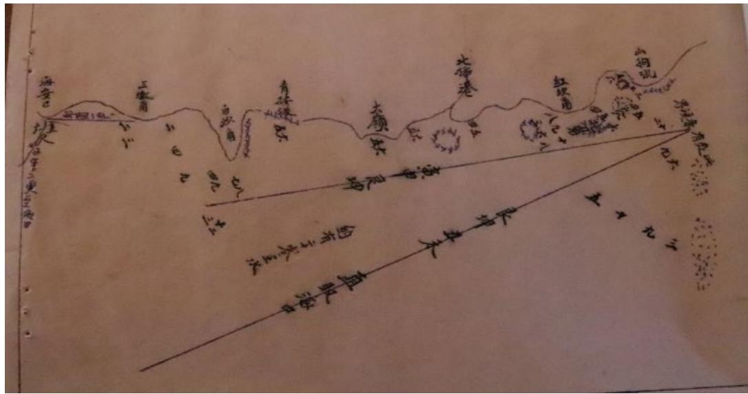
(This is page 23 of Zheng Changmei's copy of "Liushui Genglubu", and the graphics are drawn as follows: 'There is a flow boundary here'; Gen Kun, Chou Wei directly to Haikou; about twenty zero water; Zi Wu, two geng to Haikou and other records.)
# b) The
In ancient Chinese navigation activities, in addition to using the compass to identify the direction of navigation, ship positioning, mainly in the route along the coast of the mountains, islands, reefs, etc. as a reference, is to refer to the ' mountain' to determine its location. Whether the ship reaches the predetermined position or the route is correct, it is necessary to compare the mountain shape. Whether the ' mountain shape' on the water potential map is accurate or approximate determines the success or failure of navigation. Chen Lunjiong (2013) pointed out, the drawing of mountain shape is very important. Professor Yan Genqi (2019) pointed out that ' Wangshan ' refers to the obvious markers such as mountains and forests on the coast, such as Tongguling in Hainan Province, which is named after the bronze drum excavated by General Ma Yuan during the reign of Emperor Wu of the Han Dynasty. It is an important 'Wangshan' that ships from Guangzhou and other places enter the sea area east of the Qiongzhou Strait and sail southward.
In Zheng Changmei's copy of "Liushui Genglubu", there are many descriptions of the mountains. For example, from Lingao in Hainan to Bingmajiao, on the way to see the three major mountains, Songlinling, Bao 'anling and Bingmaling, From Lingaojiao to Diaoloujiao, it is necessary to turn the needle many times to change the direction, and there are many reefs. It is difficult for people who are not familiar with it to pass through. That is to say, the voyage is very complex, reefs, sand, all, the text can not be all loaded, must be very familiar with its terrain.
(This is page 5 of Zheng Changmei 's copy of " Liushui Genglubu ", From Lingaojiao to Diaoloujiao.)
### c) Drawing of water potential
In the mountain water potential map, the water potential mainly refers to the marking of the marine hydrological conditions and geological conditions around a port and 'mountain' in the map, as well as some navigational south, the most important of which is the depth of sea water and the geological conditions of the ocean, such as sand and reef.
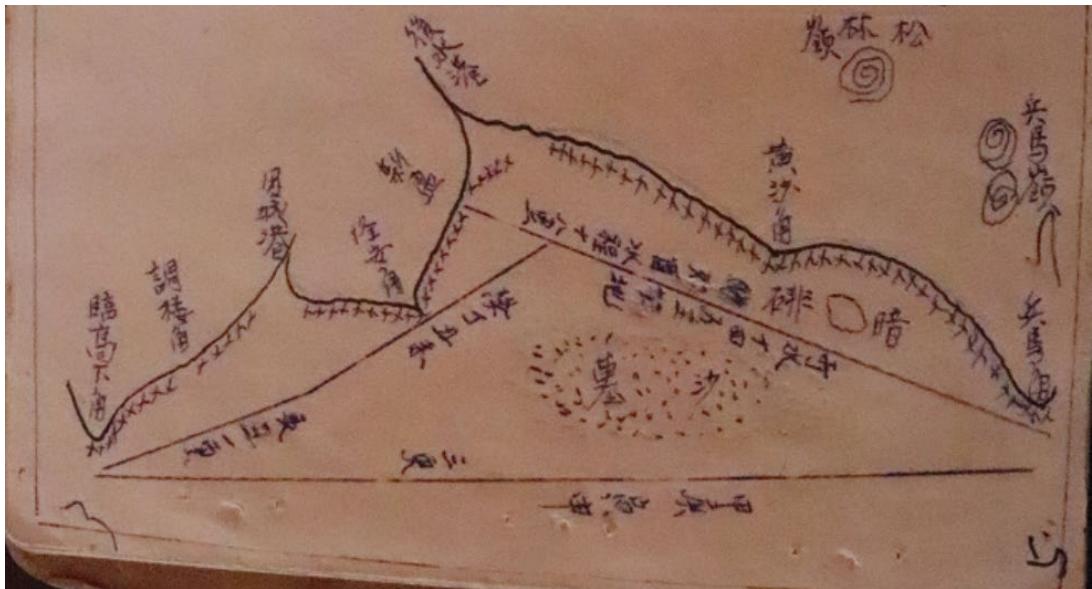
In Zheng Changmei's copy of the "Liushui Genglubu," there are many pictures that record the water potential, and there are some specific terms, such as hidden row, clear row, reef cornerstone, coarse sand, fine sand, sand land, sand mud land, mud land, Pingyang water land, Zhengli, Dashui... Bracket, water depth... A foot, offshore... Pitching, dark water all the way, etc. As shown in the figure on page 25 of this book, the map of mountain shape and water potential in Guangdong is drawn, including the mark of Naozhou lighthouse, ' here is scattered sand ', ' shallow water here ', ' Pingyang water ', ' water dry ', ' shallow water ', Zhengli and other geological conditions, water potential drawing.

(This is page 25 of Zheng Changmei's copy of " Liushui Genglubu ", The map shows the ports, routes, voyages, mountain shapes and water potential along the route from Guangdong to the East China Sea.)
### d) The integrity of the diagram
Throughout Zheng Changmei's 24 maps of 'Liushui Genglubu', it can be seen that although the 24 maps are divided into different page numbers, they are linked together to form a complete map with very obvious holistic characteristics. Among them, from page 1 to page 21, is the Hainan Island map. Starting from Haikou, Hainan Province, involving Haikou, Chengmai, Lingao, Danzhou, Changjiang, Dongfang, Ledong, Sanya, Lingshui, Wanning, Qionghai, Wenchang and other coastal cities and counties on the west and east coasts of Hainan Province, through Shashangjiao - Hongshajiao - Tianweijiao - Beinancun - Dongshuigang - Huafanggang - Yubaojiao - Magang - Hongpaigang - Beipugang - Linggaoshangjiao - Linggaoxiajiao - Tiaoloujiao - Tianchenggang - Long 'anjiao - Xinyinggang - Houshuigang - Huangshajiao - Bingmajiao - Emangang - Nantangang - Shenjianjiao - Ganchonggang - Baimajing (Yangpu) - Guanyinjiao - Haitougang - Haiweigang - Shatang - Shatang
Shatang - Shatang - Shatang Bay - Changhuajiao - Changhuagang - Changtianshagang - Yishagang - Lingshuijiao - Li 'an Port - Shuikou Port - Sugarcane Island - Xiaohuajiao - Dahuajiao - Gangbei Port - Boao Port - Qinglan Port - Tonggujiao - Paoling Port - Jiadingjiao - Jimao Bay - Wushizi - Mulantoujiao - Xinpujiao - Lingjiao - Shijiao - Puqian Port - Dongyingsha - Shazhou Port - Shazhoujiao - Haikou and other nearly 90 ports, which provides very important information for the study of Hainan 's ports, fishery resources, geological water quality, maritime transport, private trade and so on.
## V. QUESTIONS AND DISCUSSIONS ON ZHENG CHANGMEI'S COPY OF LIUSHUI GENGLUBU
The author analyzes the content and text features of the "Liu Shui Genglubu". However, there are still many doubts in this book:
a) Who did Zheng Changmei copy from?
Although the book clearly marked 'October 1980, Zheng Changmei copied', but who did Zheng Changmei copy from? There is no conclusion yet. Through interviews with Mr. Chen, Mr. Wang and other people, as well as relevant literature records, the author roughly speculated that the "Liushuigenglubu" was produced in about two stages. According to the author's research, around 1980, when Zheng Changmei copied the 'Genglubu', the original copy was written in writing brush on rice paper. According to the author interviewed Mr. Wang, originally 'Genglubu' was written on several large rice paper, he only saw one of them. According to Mr. Chen, he did a lot of research when he wrote 'Yingge Haizhi'. It can be preliminarily inferred that the emergence of the 'Liushui Gengliubu' was about two periods. The previous part of the "flowing water situation" appeared in the Tongzhi period of the Qing Dynasty, which was closely related to Mr. Ke Hongmo, the pioneer of Yinggehai culture. Ke Hongmo, born in Xianfeng Renzi year, died in Guangxu Dingyou year. He founded the first private school in Yinggehai and cultivated a large number of excellent students. The latter part of the 'mountain water potential map' should have experienced a long-term formation process, which is related to the commercial trade of Yinggehai. It was initially formed in the Qianlong period of the Qing Dynasty, and then it was continuously supplemented. The period of the Republic of China and the 1950 s and 1960 s should be the mature period.
b) Are the users of ' Liushui Genglubu ' merchant ships or fishermen?
There are different views on the discussion of this issue. One is for merchant ships. According to the author's research, Hainan Ledong Yinggehai people fishing operations, mostly in the coastal area; fishery trade is to sail around the island, or from Hainan to Guangdong, Guangxi, Vietnam and other places. 'Yinggehai Zhi' records the prosperous commercial trade of Yinggehai. In the 25th year of Qianlong 's reign in the Qing Dynasty, the commercial bank of Fang Zhiqigong in Xin 'an Village, Baishabu, Haikou migrated to Yinggehai, and soon the commercial bank of Wang Yinggong in Daojun Village, Qiongshan County migrated to Yinggehai. Since Yinggehai village, most fishermen mainly engaged in fishery production and trade. The sea area of Yinggehai is rich in seafood. The fishermen in this village generally work in the nearby sea area and rarely go to other places. The "Liushui Genglubu" records such a round-island route map as Haikou-Hainan West Coast-Hainan East Coast-Haikou, routes from Hainan to Guangdong and Guangxi, and a separate page centered on Fushuizhou, which is obviously related to commercial trade.
There is also a saying for fishermen to use, because this book has many 'fishing operations' records. The author speculates that it is more likely to be a merchant ship user. In addition to the prosperous commercial trade in the history of the Yinggehai Sea, there are many records of the rich aquatic products in the sea area of the Yinggehai Sea in the 'Liushui Genglubu': 'Yinggehai to Wanglou Port, 50 miles, this port has a lot of land'; and 'Haikang to Yupao port, where the port is less, including cargo ships can go out. Since Zhuzhou tail into the water full of port, water depth, and the depth of the water in the port, mud, can avoid the wind. The tide is full of sand, and the water depth is five, six or seven feet. There are often records of salt ships entering and leaving the port, which shows that in addition to paying attention to the mountain shape and water potential of each port, this book also pays attention to the property situation of each port, as well as the situation of cargo ships and salt ships, which is closely related to the fact that the users of this book are merchant ships.
### c) Zheng Changmei's copy deposit book 'Liushui Genglubu' may be a family biography
Where is the copy of Zheng Changmei's copy of 'Liushui Genglubu' copied from? It has not been confirmed. However, it is speculated that the book may be his family biography. According to the introduction, Zheng's family is a generation of fishermen and merchants. Although Zheng Changmei did not go to sea to fish and do business, his grandfather and father all lived on fishery and commerce, and the people in his family had received certain cultural education. According to the 'Zheng's genealogy', Zheng 's Wenjinggong moved to Yinggehai from Lingjiao Village in Qiongshan in the 54 th year of Qianlong in the Qing Dynasty (AD 1789) to make a living by fishing. Zheng's hall name 'Rongyang hall'. Zheng Changmei is the sixth generation of Zheng's descendants. He did not go to the sea, but participated in the revolution very early. He was the first batch of intellectuals to join the party in Yinggehai, and returned to Yinggehai around 1979. After returning home, he rarely left home for other reasons. Due to Zheng Changmei's high cultural level and good writing skills, he is often asked to help copy things. If this is someone asked him to copy, then, after copying, should be returned to others. However, the book was kept in Zheng Changmei's home, indicating that he was not asked to copy it.
In addition, according to Mr. Chen, there is no second similar "Liushui Genglubu" in Yinggehai, and there are very few "mountain shape and water potential maps" of "Genglubu" found elsewhere in Hainan, indicating that there is little possibility that the book is copied from other places.
## VI. CONCLUSION
In summary, although Zheng Changmei's copy of "Liushui Genglubu" still has many doubts, there is no doubt that its characteristics and value are still very obvious.
First, the "Liushui Genglubu" is a relatively complete and systematic combination of text and graphics found so far, especially the 24 charts, which provides very valuable information for the study of the development and history of China's seaway maps and mountain water potential maps. It is also conducive to our further study of ancient navigation knowledge, navigation technology, and maritime traffic.
Secondly, the sea routes and voyages around Hainan Island recorded in this book almost include the important ports, routes and sea areas of cities and counties in Hainan Province. It is of great significance to understand the maritime traffic, port conditions, topography and folk trade in Hainan Province.
Third, the flow record of the 'Six Collision Flow Methods' recorded in this paper supplements the record of the flow in the west of Hainan Province; the route centered on Fushuizhou in Vietnam and some records reflecting the commercial trade of Yinggehai in Ledong, Hainan Province, reflect the characteristics of the western route of Hainan Province and some characteristics of the use of 'Genglubu' by commercial ships.
[^1]: Fund: The National Social Science Foundation of China project "Investigation, collation and research on marine cultural heritage of Dan people in southeast coast of China" (22BZS155) _(p.1)_
Generating HTML Viewer...
References
8 Cites in Article
N Liu,Zh Zhang (2015). China’s development and administration of Xisha and Nansha Islands.
Ch Wang,G Yan,L Liu (2018). Genglubu discovered and studied for forty years.
Zh Gong Preface to the Western Tributary Records.
Y Liu (2015). Research on the Shanxing shuishi tu.
D Li (1996). Bailongwei Island corrects name.
X Zhang (1980). Preface.
L Chen (2013). Geographical Records of the World "Nanyang Chronicle.
Xin Wu,Jie Zhong,Haiquan Zhang,Houji Liu,Junping Mai,Se Shi,Qijiu Deng,Ning Wang (2019). Garnet Li7La3Zr2O12 Solid-State Electrolyte: Environmental Corrosion, Countermeasures and Applications.
No ethics committee approval was required for this article type.
Data Availability
Not applicable for this article.
How to Cite This Article
Zhou Jun. 2026. \u201cThe Newly Discovered Graphic-text Combined Study of Liushui Genglubu in the South China Sea\u201d. Global Journal of Human-Social Science - D: History, Archaeology & Anthropology GJHSS-D Volume 23 (GJHSS Volume 23 Issue D2): .
Explore published articles in an immersive Augmented Reality environment. Our platform converts research papers into interactive 3D books, allowing readers to view and interact with content using AR and VR compatible devices.
Your published article is automatically converted into a realistic 3D book. Flip through pages and read research papers in a more engaging and interactive format.
The newly discovered Hainan fisherman Zheng Changmei’s copy of the South China Sea ‘ Liushui Genglubu ‘ is divided into two parts : ‘ Liushui Record ‘ and ‘ Mountain Water Potential Map ‘. It is the only complete graphic-text combination of the South China Sea ‘ Genglubu ‘ found so far. This book records the tide situation in the western sea area of Hainan Island, the route around Hainan Island, the route distance from Hainan Island to Guangdong province, Guangxi province of China, Vietnam and other places, and 24 ‘ mountain water potential diagram ‘. The discovery of this book proves the use of ‘ Genglubu ‘ by merchant ships in Hainan Island; the 24 sea charts are the continuation and development of the rare mountain shape and water potential maps in the literature of the past dynasties. The drawing of the mountain shape and water potential has the characteristics of integrity, which makes up for the rare sea charts in the ‘ Genglubu ‘ of the South China Sea.
Our website is actively being updated, and changes may occur frequently. Please clear your browser cache if needed. For feedback or error reporting, please email [email protected]
Thank you for connecting with us. We will respond to you shortly.