In Manacapuru, the region of Solimões River is one lowland, which is formed by fragile soil. Construction in these areas can be affected by several difficulties, such as building instability due to the force of waters during floods and rotting of pillars. Other aspects of the phenomena of nature, such as floods, rain, and moisture, require high maintenance expenses and a short life cycle in wooden buildings. These factors make this population more vulnerable, as well as the risk of losing their home, furniture and personal property. This region is undergoing significant transformations, so many parts of the territory are at risk of landslides and soil erosion. The method consisted of a case study, website visits, production of maps with QGIS and Google Earth, redesign of areas vulnerable to flooding and geological risk. The analysis concludes in the neighborhood Terra Preta the possibility of geological risk is high, but contained in the low-lying areas and the stream. The Correnteza neighborhood presents a greater risk of flooding because it has two influences from the Solimões River and the sandy surface river Areal. Most of the buildings are on wooden stilts, and there are more houses with instability and maintenance issues.
## I. INTRODUCTION
The environmental context in the Amazonian is very relevant for the world, such as hydrological forms, rivers, lakes, streams, beaches, and boreholes.
The "flood planning presents a great diversity of morphology and reflection of soil deposits that are still active." Among them, the "flood plains" were installed on broad terraces with the "hydrographic basins of the Negro, Solimões and Amazonas rivers complex". Manacapuru is in this environment, as argued Dantas & Maia (2010, p.34).
Awareness of the region's watercourses and the phases throughout is crucial for the survival of native people, especially those who live in the area and survive fishing (Meirelles et al., 2017).
Costa et al. (2018) observe how climate change and global warming have increased maximum flood levels and how this affects riverside populations and their habitats.
In the Amazon region, in many areas, the soil is fragile. Therefore, in addition to floods, there are "fallen lands" phenomena caused by the forces of "river water flow" by "removal of material from the marginal embankments of river channels." These factors occur in drought periods with the rupture of these walls (Lana et al., 2021, p.12).
Alves (2006, p. 45) observes that social vulnerability is directly associated "with families in financial need who, when exposed to risks, present an inability to react and the difficulty of adapting to the materialization of risk".
Freitas & Cunha (2013) highlight that socio-environmental damage occurs when its inhabitants are subject to social vulnerability in line with risks such as extreme natural phenomena or pollution.
In urban areas, the lack of adequate drainage leads to rapid changes in the environment with high precipitation levels, which causes record floods. It is noteworthy that fragile soil causes different problems for these populations. These elements, associated with social vulnerability, make housing issues in the Amazon region complex. "Anthropogenic factors resulting from human action and without guidelines from city halls increase the risks for this population" (Meirelles et al., 2019, p.96).
In the main cities of underdeveloped countries, impoverished migrants end up opting for housing in peripheral areas, as highlighted by Saunders (2013). Meirelles et al., 2019, p. 96) reinforce that this "fact occurred in Manacapuru, in neighbourhoods such as Liberdade, Biribiri, São Francisco, and Correnteza."
Costa et al. (2018, p.9) analyzed the context associated with the term "social vulnerability" and emphasize that it encompasses multiple factors, including limited financial, inadequate education, health and safety concerns, besides living in areas lacking urban infrastructure, among others.
Given the environment's complexity, this research aims to evaluate the main conditions that promote socio-environmental vulnerability in the Correnteza neighborhood in Manacapuru compared to the Terra Preta district. In this work, the issues arising from climate change will be analyzed, but not limited to floods and landslides in buildings, as well as their repercussions on the daily lives of riverside dwellers.
## II. METHODOLOGICAL PROCEDURE
The methodological procedures apply the case study strategy, emphasizing the neighbourhoods of Correnteza and Terra Preta in Manacapuru, state of Amazonas, Brazil.
Phase 1: The literature review aimed to identify the concepts of socio-environmental vulnerability and the risks of geological accidents in the Amazon context.
Phase 2: Visits to the Manacapuru region
The first visit took place in 2016 by members of the Constructive Systems in Contemporary Architecture group of the FAU-Mackenzie Architecture School of São Paulo, Brazil, with support from the NGO — Amazon Vida. The second was in 2017, with the University of Amazonas-UFAM with the Interaction Group. The third field study was at the beginning of 2024 to collect data from the Terra Preta neighborhood. This study relates the internationalization program CAPES-PRINT of the Mackenzie Presbyterian University with the Escuela Técnica Superior de Arquitectura de la Universidad de Sevilla (ETSA_US).
Phase 3
Drawings of maps of the environment, the city and its neighborhoods, the equipment currently, the risk areas with Google Earth and the QGIS platform, and the characteristics of the city.
Phase 4
The analysis of case studies was performed with emphasis on the concepts of socio-environmental vulnerability presented in the article by Freitas & Cunha (2013), the concepts of socio-environmental and risk highlighted by Andrade et al. (2017), and Costa et al. (2018) arguments the risks of geological accidents through the publications of the Brazilian Geological Institute-SGB-CPRM, among other relevant authors. It is worth mentioning that in the IBGE census of 2022, only the total population of the cities is collected, however, the detailed survey as schooling, sex, residents by neighborhood, income, etc., is still from 2010 because, in 2020, the COVID-19 Pandemic occurred pandemic[^1].
## III. RESULTS AND DISCUSSIONS
Farias & Mendonça (2022, p.6) notes that "the notion of risk applied to urban floods corresponds to an uncertain situation" directly connected "to an extreme hydrological event" affecting "an individual or a population, putting at risk the integrity of their tangible and intangible assets". The authors highlight that "tanger and social vulnerability".
Leite et al. (2024, p. 3) discuss that "he socio-environmental risks of flooding only occur in the simultaneous presence of a natural flooding model in medium-sized Brazilian cities" highlighting that the "risks of urban flooding" exist due to the "deficiency of urban infrastructure in containing the flow of rainwater". In the context of Amazonian cities, housing areas located in floodplains are naturally flooded areas.
When analyzing housing the risk of floods, this research applied the parameters established by Andrade et al. (2017, p.1). According to the authors, the occurrence of maximum flood levels increases the probability of damage to vulnerable structures,
...a very high-risk designation corresponds to drainage with a high frequency (at least three events in the last five years) of floods and a very high probability of damage due to the presence of vulnerable structures. High risk corresponds to drainage with a moderate frequency (at least one event in the last five years) of flooding and a high probability of damage due to the presence of vulnerable family structures. Moderate risk corresponds to a moderate frequency (at least one event in the last five years) and low susceptibility of structures to damage caused by floods. Low risk corresponds to the absence of flood events in the previous five years and the absence or presence of structures with low susceptibility to flood damage. (Andrade et al., 2017, p.1) In this sense, riverside residents are alert when the water exceeds historical maximum levels. This fact is recurrent in the region, presenting risk conditions near rivers, lakes, and streams. The CPRM text by authors Callegario & Ladeira (2018) reinforces that in 2013, five thousand people lived in risk areas in Manacapuru.
Analyzing the publication of Oliveira (2017) with data from ANA-National Water Agency, measurements carried out on the Solimões River in Manacapuru between 1972 and 2015 presented in Nogueira et al. (2015), the analyzed data indicated that it is observed that flood peaks had a longer temporal distance, with an average of 10 years. When analyzing current data, it is estimated that the historical maximum levels occurred in 2009, 2012, 2015, and 2021, with an average of five years between them. The water level reached 20.78 meters in 2015 and 20.86 meters in 2021. The levels in 2012 and 2013 were very close, and meteorologists did not consider the level in 2013 (Maciel et al., 2023) (Matos et al., 2021).
Manacapuru is the third city in the state of Amazonia in terms of population, with a current population of 101,883 individuals. It is estimated that $60\%$ of this population lives in urban areas, and the remainder are riverside communities (IBGE, 2022).
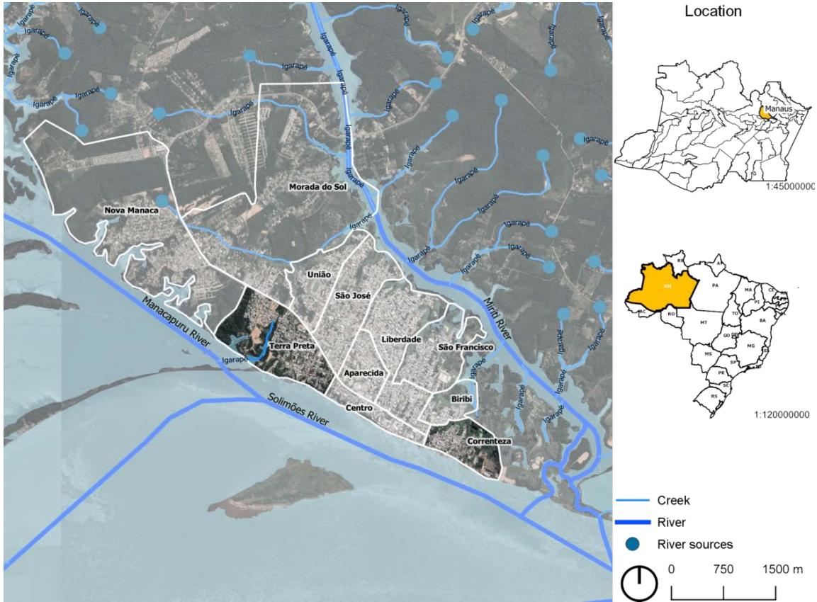 Figure 1: Maps of Manacapuru's situation and highlights of the two neighborhoods and the location in Brazil
Source: The authors, as compiled by QGis software. Data: Google Earth, ANA and IBGE In Figure 01, on the right, presents Brazil as the State of Amazonas, painted in yellow. The City of Manacapuru the case study are shown in Figure 01, on the left, with a focus on the areas around Correnteza, Terra Preta. And it is noticed that Bairro Correnteza is
located in a strip of land between two watercourses. The City grows towards the Northwest. Above the city is the network of streams that make up the water network of the Miriti River. Terra Preta is located in the central area of the town.
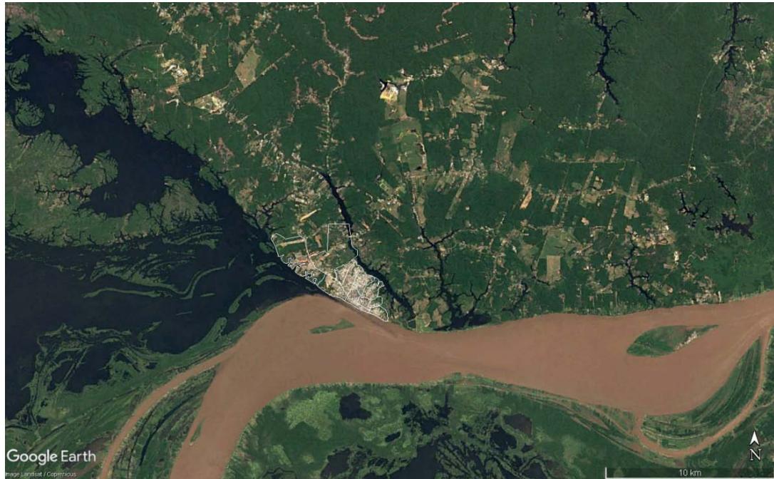 Figure 2: Map of the city and Amazon environment with hydrographic basin.
Source: The authors with Google Earth.
It is observed that "the municipality of Manacapuru-AM is delimited by two river basins, that of Solimões River and that of Manacapuru River" (Callegario & Ladeira, 2018). It is illustrated in Figure 02 that the city is delimited by several watercourses, such as the Solimões River and the Miriti, and that there is a wide variety of rivers and lakes, including Biribiri, Miriti, and Cabaliana lake. The meeting of the two takes place above the city, between the black waters of the Manacapuru River and the muddy waters of Solimões. On map 01, the blue of Solimões is imported from QGIS, however it is observed that the natural color of the Solimões River is muddy due to the "sediments that drain the eastern slope of the Andes mountain range". In black rivers, "it is due to the high concentration of iron sesquioxides" (Dantas & Maya, 2010, p.35).
### a) Landslide Risks
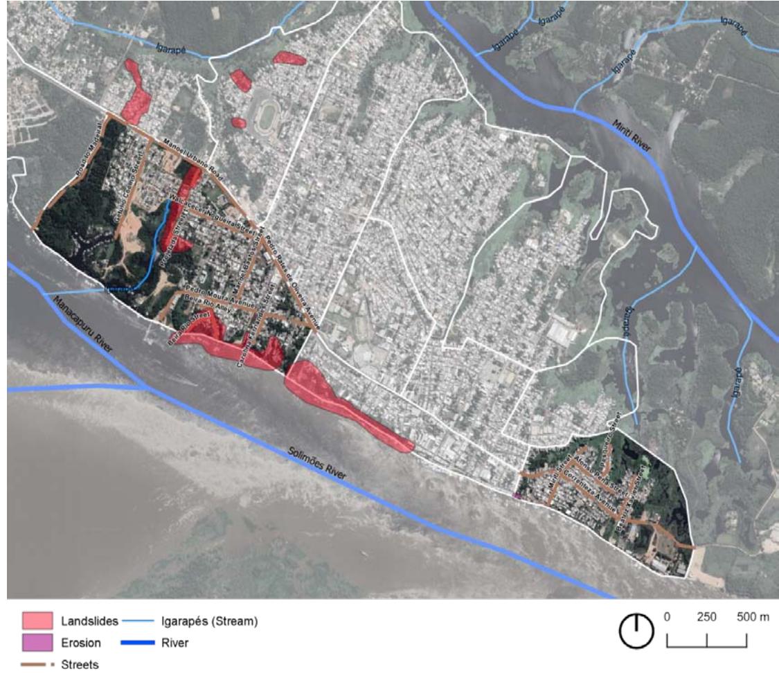
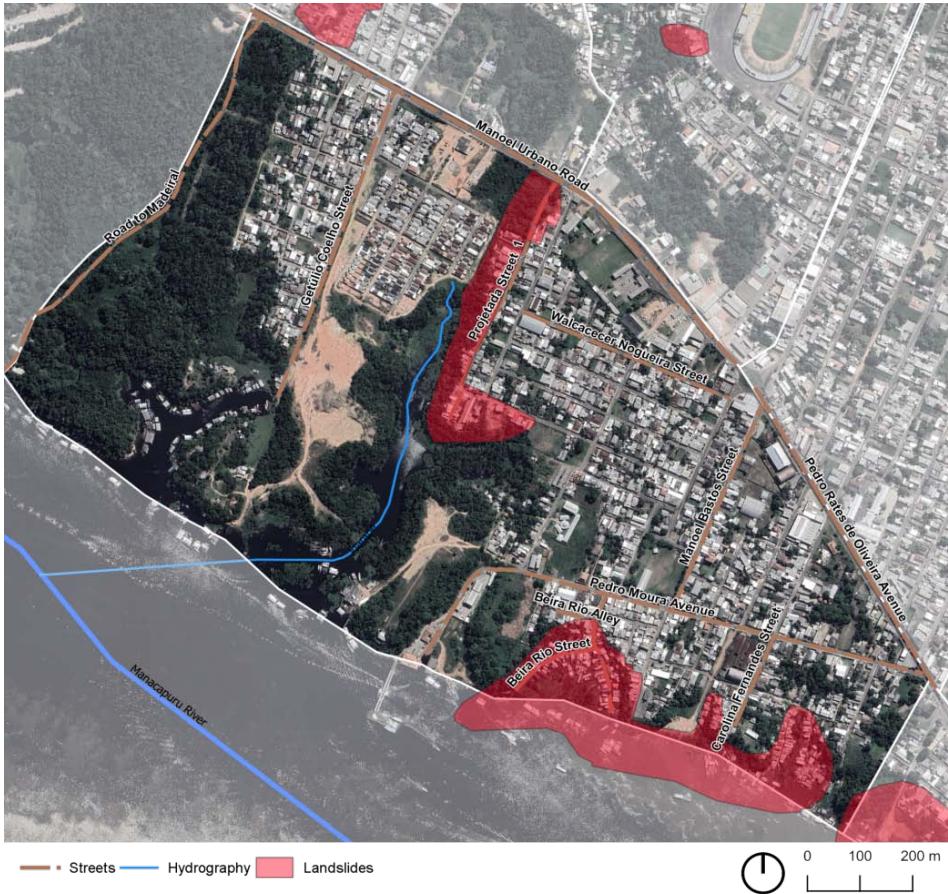
As already noted, the Manacapuru region, in addition to the risks of flooding, has areas with tendencies to have landslides and erosion. On map 03, the risk of regions the landslides was highlighted in red. The Brazilian Geological Institute classifies geological hazard risk as "very low, low, high, and very high" (SGB, 2018, p.1).
The map shows the critical geological areas on the edge of Manacapuru and next to streams. Thus, the risk class is high due to the conditions for landslide processes, as well as the "significant presence of signs/ features/evidence of instability (cracks in the ground, slope steps, etc.)" so it is possible that "during heavy and prolonged rains the phenomenon occurs." (Lana et al., 2021, p.23).
 Figure 3: Maps of geological risk areas in Manacapuru
Source: The authors, as compiled by QGs software. Data: Google Earth and Brazilian Geological Institute-SGB
### b) Analysis of the Terra Preta Neighborhood
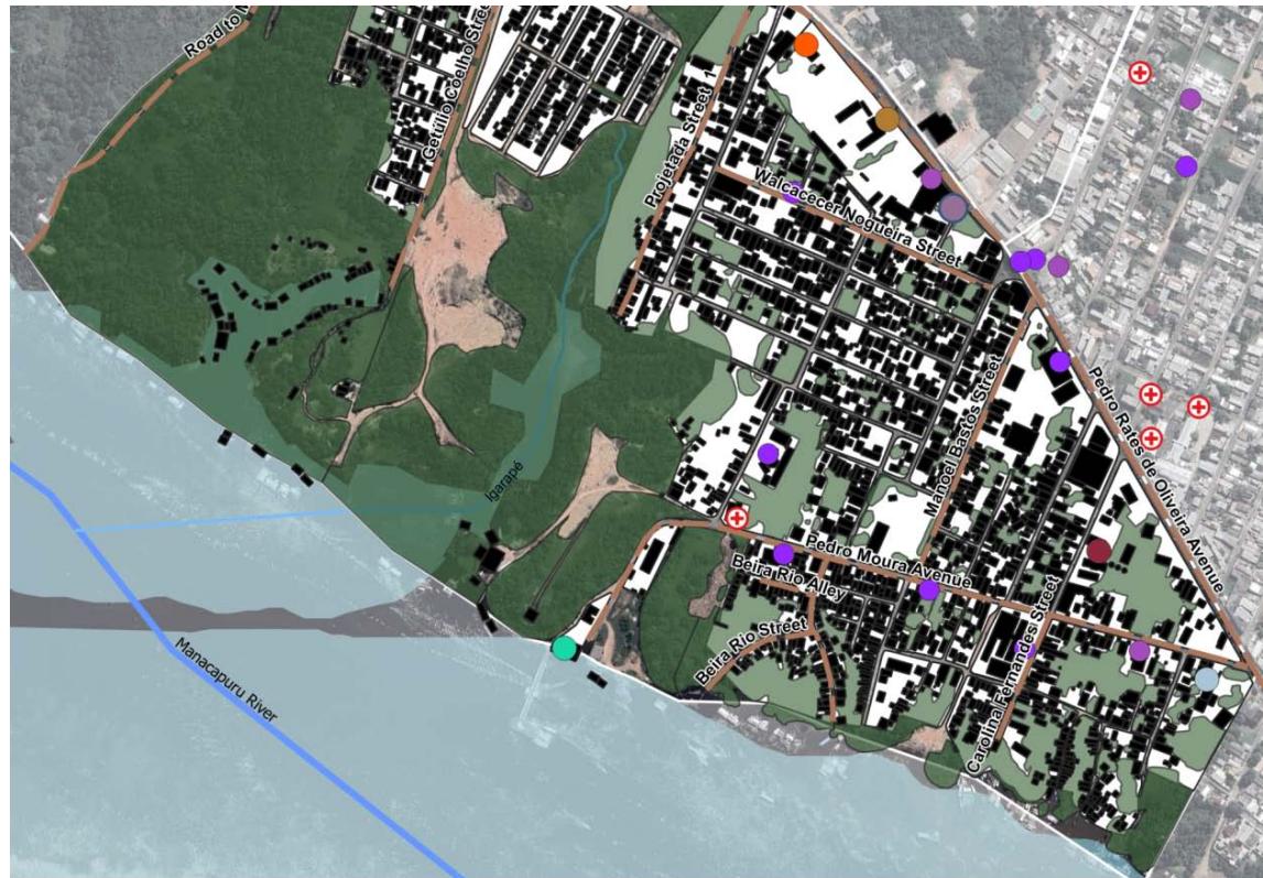
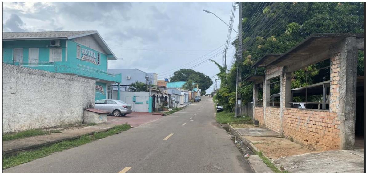
According to Amorim (2013, p.34), "Terra Preta is one of the oldest districts in the city". However, its formal constitution took place around 1930. This was one of the main places where the Mura people were established when they moved to Manacapuru. Figure 03 highlights the urban elements of the Terra Preta district. The image was created based on Google Earth and QGIS. Today, the neighborhood is home to the City Hall, two hotels, two state schools, a university, and the port of Manacapuru. According to IBGE (2010), 5389 people lived in the Terra Preta, data from $2010^{2}$.
 Manacapuru harbor Elementary and high school University education Healthcare Military Fire Brigade St. Alphonsus Catholic Church
Amazonas's Military Police
Manacapuru City Hall
Brazilian Micro and Small Business
Support Service (Sebrae Manacapuru)
Streets
Buildings
Squares In terms of territory, the Terra Preta neighborhood occupies a large block with higher elevations than Correnteza. On the map above, the highest points in the area appear on Manoel Urbano Road, which is an extension of the Pedro Rates de Oliveira Avenue Boulevard. It can be seen that a long stream begins a little above the Manoel Urbano road and continues parallel to Projetada Street, the upper part of Figure 4. The lowest quotas are next to the Solimões River, like Beira-rio street, the shape of which represents the outline of a creek next to the Port of Manacapuru. The two red spots represent the risk of landslides, as shown in Figure 5.
Amorim (2013, p.37) notes, "Beira-Rio street is where riverside dwellers sell their production, coming from Santo Afonso beach, located in front of Manacapuru."
The author further emphasizes that in 2005 and 2010, the residents of the Beira-Rio street had already experienced hardships due to the fall of solo in the Terra Preta. According to him, "the danger is higher in the descent of waters during the dry period of the rivers". Many residents of the 2005 incident received homes in a housing complex built by the City Hall. However, several of them returned, as this region facilitates access to the river, and they need to be close to their livelihood and work.
On October 11, 2023, a new landslide occurred in the Terra Preta district, as highlighted in the BNC report "Manacapuru: landslides into the Solimões, dragging boats, and one person disappears." (BCN, 2023, p.1).
 Source: The authors were prepared using QGs software. Data: Google Earth and Brazilian Geological Institute-SGB Figure 5: Maps of geological risk areas in the Terra Preta neighborhood
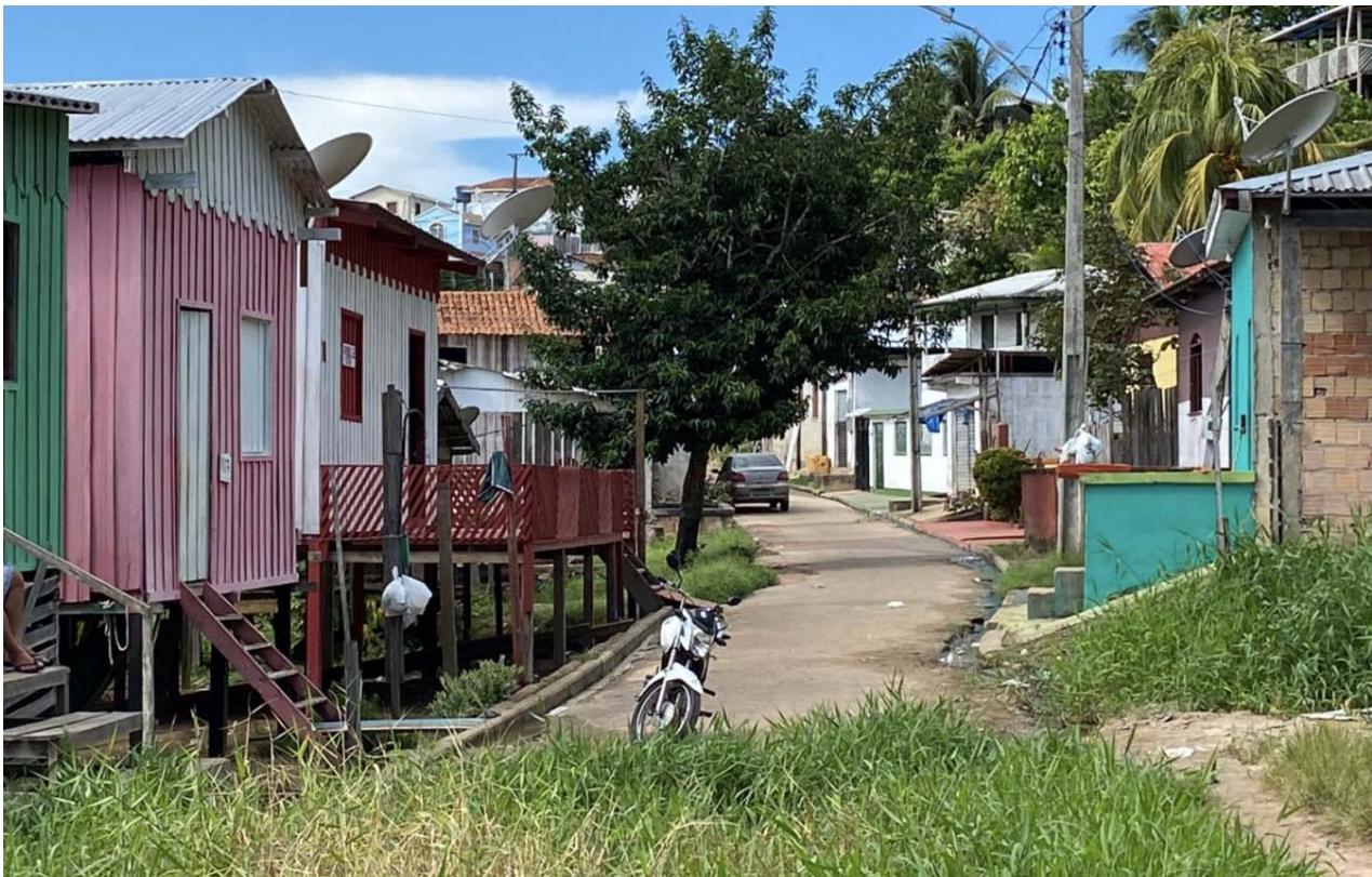
Regarding the materiality of the buildings, it was observed that most buildings in the Terra Preta neighborhood are made of masonry with one floor or two. The areas close to Solimões are more vulnerable to flooding, the villas are made of wooden stilts. Figure 06 shows Walcace Nogueira Street, and in this area it observed the predominance of buildings built in masonry. Figure 07 shows houses on Beira-Rio Street with colors typical of riverside communities. On the left side, we can see houses made of wooden stilt and on the right side, masonry houses. Image 08 shows a house next to Solimões that is in a significantly deteriorated stage.
 Source: The Authors Figure 6: Walcace Nogueira houses
 Source: The Authors
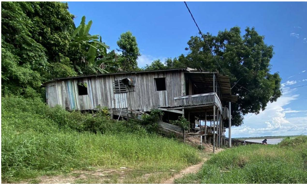 Figure 7: Beira-Rio houses Source: The Authors
### c) The Correnteza neighborhood
The construction of small bridges over rivers and streams in Manacapuru in the 1970s promoted the appropriation of peripheral areas, such as the
Correnteza neighborhoods (Lima, 2012). The illustration 09 depicts the urban setting of the Correnteza neighborhood, including residential structures, commercial activities, educational institutions, a church, and the fishing sector. According to IBGE (2010), 4702 people lived in the Correnteza.
The Solimões River can be seen in front of the cities, and the green masses represent springs due to the shallowness of the soil and the ease with which water emerges. The main avenue of the neighborhood is the Avenue of the Correnteza. From the street Afonso Pena, water springs extend until the back of the city, at the time of the flood, forms a lake where residents park boats, as a fishermen's street.
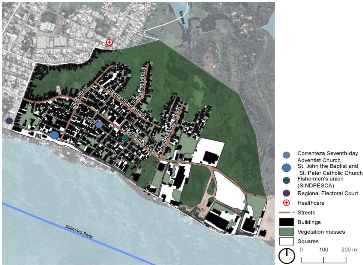 Figure 9: Map of urban elements and environmental composition in the Correnteza neighborhood
Source: The authors were prepared using the QGs software.
The construction of stilts was applied by several peoples, with traditional technique passed down from father to son. Its application in general is in the regions of beach, mountains, and floodplain. Zhang Xu & Wang (2022, p.1), study the village of Tujia in China, which uses the construction system on wooden stilt, and the importance of "conservation and regeneration can keep traditional building systems alive and sustainable", with the first floor is raised from the ground to adapt to the "different terrains". In his sketches, it is noted that the main pillars support the elements of the roof, "wooden stakes in the under the building". The buildings in Manacapuru lost relevant elements to maintain the comfort of the buildings and extend their life cycle. The construction uses metal tiles, small eaves, no balconies around the house, etc. The majority of housing buildings in the Correnteza neighborhood are made of wooden stilts, on average $60\%$ of them are wooden, and $40\%$ are masonry. As shown in Figures 10 and 11:
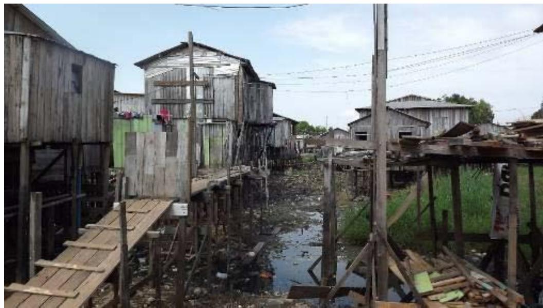 Figure 10: Houses made of stilts in Correnteza neighborhood
Source: The authors
The Manacapuru City government implemented its master plan in 2006, establishing risk management strategies with the creation of the Civil Defense Secretariat (Municipal Government of Manacapuru, 2006). Currently, the plan is undergoing a new revision. During field visits, actions by the institution were observed, predicting future problems and identifying buildings at risk of collapse, shown in Figure 11, these were marked with the acronym MPU. However, between 2016 and 2017, several buildings lost their stability. Civil defense agents emphasized that the city government built a housing complex with financing from the "Minha casa, minha vida program". However, many residents of this region did not have the documents and conditions to prove their income to obtain financing.
The loss of equilibrium in riverside houses in the Manacapuru region is attributed to various factors, mainly to the weight of wooden posts on fragile soil. The second factor, "seasonal fluctuations between floods and dry" causes the wood to rot in the ground. The third characteristic that leads to the loss of overall stability of homes is "the lack of structural bracing elements in the buildings; these were applied during construction, but removed by builders at the end of the work." (Meirelles et al., 2019, p.96).
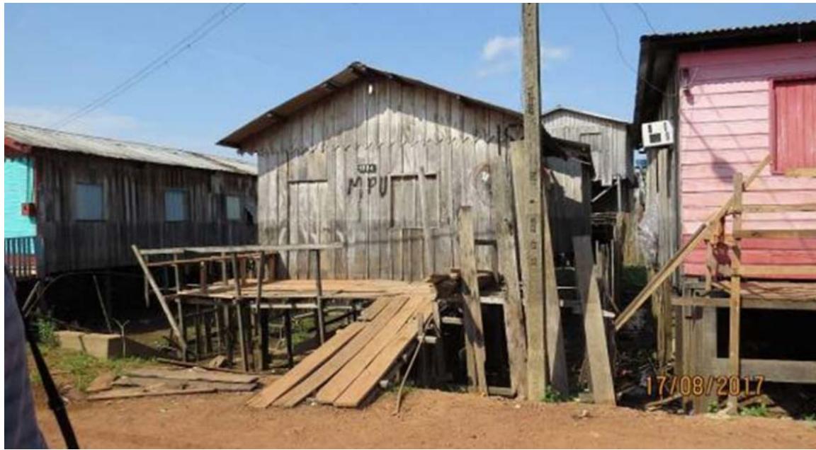 Figure 11: Houses in the Afonso Pena Street—Correnteza neighborhood at risk
Source: The Authors
Meirelles et al. (2019, p.96) reinforce that in vulnerable situations, riverside residents do not have the time or financial conditions to rebuild their place of residence with dignity. A resident of the Correnteza neighborhood lost her house twice in a short period, once in 2012 and once in 2015. In 2015, "a total loss occurred." The building collapsed with the mother and children. The image in Figure 12 illustrates the Correnteza neighborhood, highlighting the areas most susceptible to flooding. The influence of internal streams was shaded in light pink, and the flood-prone area next to Solimões was shaded in light yellow. One point of risk to erosion stands out next to the Solimões River, but it can be seen that this is isolated. As shown in the image below, during floods, houses in low-lying areas, close to springs and stream networks, become isolated. This often happens on the streets of Afonso Pena, Miriti, Pesqueiro and Beatzix Xavier.
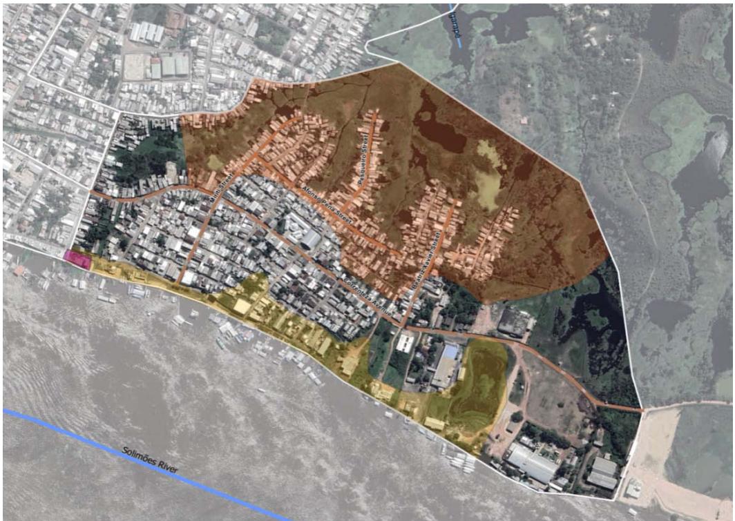 Figure 8: Houses in the Terra Preta neighborhood next to Solimões
 Area flooded by the Solimões River - Igarapés (Stream) Area flooded by Igarapés (streams) - Rivers
 Erosion
 0 100 200m Source: The authors, based on SIPAM, ANA and Google Earth. Figure 12: depicts the areas that are most susceptible to flooding in the Correnteza neighborhood and the associated geological hazards.
### d) Problems of the population of the two neighborhoods
The social vulnerability can be expanded with extreme environmental conditions highlighted by Costa et al. (2018); the research shows the socio-environmental concepts highlighted by Andrade et al. (2017) occur in these two neighborhoods. In 2021, a maximum level occurred (historical quotas), highlighting that an event occurred in the past five years. In addition to these factors, there is a risk of the fragility of the buildings, as already discussed in the text of this article. Another severe problem is decrease in the recurrence time of the historical maximum levels and increasing the maintenance of buildings.
The wooden structures and walls of the houses as shown in figures 10 and 11 present conservation and maintenance issues. According to the civil defense of
Manacapuru in the year 2024, the most vulnerable dwellings in the Correnteza neighborhood were listed as 610 dwellings, primarily affected by flooding.
There are 238 houses in the Terra Preta neighborhood, but in this area, the risk of landslides is increased, and the risk of flooding is lower, as discussed in the article's text. This fact can be observed in areas at risk of landslides, marked as figure 05 on Rua Projetada, which had 38 houses with problems. This fact can be observed in the landslide risk maps demarcated on map 05 in Projetada Street, which had 38 houses with issues.
Table 1
<table><tr><td></td><td>Total Number of
Residents</td><td>Total Number of
Houses, An Average of
4 Residents</td><td>Number of Houses with
Problems</td></tr><tr><td>Correnteza</td><td>4702</td><td>1175</td><td>610</td></tr><tr><td>Terra Preta</td><td>5389</td><td>1347</td><td>238</td></tr></table>
According to IBGE (2010), Manacapuru City has an average of 3.78 residents per household, was considered in the statistical analysis 4. It is observed that there is a higher probability of issues in the neighborhood of Correnteza around $51.3\%$, whereas Terra Preta has an average of $17.6\%$.
## IV. FINAL CONSIDERATIONS
The present work demonstrates the complexity of the environment in the Amazon region due to the hydrographic and climatic regime with extreme precipitation levels and the constant transformation of floodplains, generating areas susceptible to flooding and geological risks.
Another aspect discussed in this paper is the influences of climate change in place, and how the increase in maximum flood levels and the reduction in recurrence time, these factors generate several problems for buildings and difficulties for their inhabitants. These elements reinforce the theory that areas subjected to flooding that exceed historical levels lead to a short life cycle for buildings and a high maintenance cost over time. These components make local inhabitants more vulnerable, in addition to the risks of loss of buildings, furniture, and personal property.
A relevant point is the fragility of soil formation in this region, which has already been mentioned in the text. In 2023, when a geological accident happened during a dry period. This is why maps of geological risks are important and can help predict issues.
In cities like Manacapuru, civil defense work is of great relevance in mapping and identifying risk areas and creating alert systems for isolated communities, with a support network between universities, research centers, and municipal governments.
[^1]: Formal information received from the head of the IBGE agency in Manacapuru in January 2024. _(p.2)_
Generating HTML Viewer...
References
24 Cites in Article
Antônio Amorim,Ailson Cavalcante,De (2013). Terra Preta: a origem.
Bnc,Manacapuru (2024). terra desliza no Solimões, arrasta barcos e uma pessoa desaparece.
Milena Andrade,Iris Bandeira,Dianne Fonseca,Paulo Bezerra,Ádanna Andrade,Rodrigo Oliveira (2017). Flood Risk Mapping in the Amazon.
Humberto Alves,De (2006). Vulnerabilidade socioambiental na metrópole paulistana: uma análise sociodemográfica das situações de sobreposição espacial de problemas e riscos sociais e ambientais.
L Callegario,L Ladeira (2018). Setorização de áreas em alto a muito alto risco a movimentos de massa, enchentes e inundação: Manacapuru.
A Farias,F Mendonça (2022). The Urban Environmental System perspective on socioenvironmentalrisksofurbanflooding.
Katharine Rasori,Antonia Barroso,Érika Pinheiro (2006). Plano de gerenciamento de resíduos sólidos em uma empresa de produção de polpas de frutas em Manacapuru – AM / Solid waste management plan in a fruit pulp producion company in Manacapuru- AM.
M Costa,M Santos,B Marguti,N Pirani,C Pinto,R Curi,M De Dantas,M Maia (2010). Compartimentação Geomorfológica.
M Freitas,I,C Cunha,L (2013). Cartografia da vulnerabilidade socioambiental: convergências e divergências a partir de algumas experiências em Portugal e no Brasil.
(2021). Cidade de Manacapuru.
M Oliveira (2017). Monitoramento hidrológico, boletim n.39. ANA. CPRM.
Júlio Lana,; César,Denilson Jesus,Tiago De; Antonelli (2021). Guia de procedimentos técnicos do departamento de gestão territorial: setorização de áreas de risco geológico.
Marcos Leite,Felipe Dias,Jefferson Almeida,Narciso Santos-Neto (2024). Land use and environmental impacts: Flood model in a medium-sized Brazilian city as a tool for urban sustainability.
Jussara Maciel,Luciana Loureiro,Renato Senna,Andre Dos Santos (2023). A estiagem de 2023 como evento hidrológico severo na bacia do Amazonas.
Tiaraju D’andrea (2018). Contexto histórico e artístico de produção do fenômeno Racionais MC’s.
A Matos,B Oliveira,L De; Alves,M Santos (2021). Sistema de Alerta Hidrológico do Amazonas: relatório técnico de operação do ano de 2021.
Célia Meirelles,Silvio Sant'anna,Vanessa Souza,Flávio Marcondes,Lucas Fehr,Jair Oliveira Junior,Guilherme Michelin,Gilda Bruna,Fabio Raia (2019). A gestão da construção civil por meio de inovações tecnológicas.
C Meirelles,F; M; Raia,G Bruna,F Marcondes,L Fehr,S Sant'anna,Oliveira,J Junior (2018). As Características da Habitação Ribeirinha no Estado do Amazonas: Rebatimentos na Qualidade de Vida.
C Meirelles,F Marcondes,G Bruna,L Fehr,S Sant'anna,F Oliveira Junior; Raia (2017). Relatório Técnico Científico. Processo Construtivo da Habitação em Madeira: Interfaces e Rebatimentos nas Populações Ribeirinhas do Amazonas.
Edileuza Nogueira,M De,M Parise,T Kuck,P De Almeida,C Jorg,A Costa,Da Costa (2015). Modelagem das Ocorrências a Inundação no Município De Manacapuru/Am. XVII Simpósio Brasileiro de Sensoriamento Remoto -SBSR.
Maria Lima,Feitosa (2012). Produção do espaço urbano e impactos socioambientais na cidade de Manacapuru-AM - o bairro de Biribiri.
M Oliveira (2017). Monitoramento e caracterização molecular de arbovírus em dípteros da Amazônia ocidental brasileira (estado de Rondônia e Amazonas)..
Sgb (2024). Áreas de deslizamento em Manacapuru.
T Zhang,H Xu,C Wang (2022). Selfadaptability and topological deformation of Ganlan architectural heritage: Conservation and regeneration of Liang Shekou Tujia village in Western Hubei, China.
No ethics committee approval was required for this article type.
Data Availability
Not applicable for this article.
How to Cite This Article
Célia Regina Moretti Meirelles. 2026. \u201cThe Problems of Building Construction in Manacapuru-AM: The Correnteza and Terra Preta Neighborhoods\u201d. Global Journal of Human-Social Science - B: Geography, Environmental Science & Disaster Management GJHSS-B Volume 24 (GJHSS Volume 24 Issue B4): .
Explore published articles in an immersive Augmented Reality environment. Our platform converts research papers into interactive 3D books, allowing readers to view and interact with content using AR and VR compatible devices.
Your published article is automatically converted into a realistic 3D book. Flip through pages and read research papers in a more engaging and interactive format.
In Manacapuru, the region of Solimões River is one lowland, which is formed by fragile soil. Construction in these areas can be affected by several difficulties, such as building instability due to the force of waters during floods and rotting of pillars. Other aspects of the phenomena of nature, such as floods, rain, and moisture, require high maintenance expenses and a short life cycle in wooden buildings. These factors make this population more vulnerable, as well as the risk of losing their home, furniture and personal property. This region is undergoing significant transformations, so many parts of the territory are at risk of landslides and soil erosion. The method consisted of a case study, website visits, production of maps with QGIS and Google Earth, redesign of areas vulnerable to flooding and geological risk. The analysis concludes in the neighborhood Terra Preta the possibility of geological risk is high, but contained in the low-lying areas and the stream. The Correnteza neighborhood presents a greater risk of flooding because it has two influences from the Solimões River and the sandy surface river Areal. Most of the buildings are on wooden stilts, and there are more houses with instability and maintenance issues.
Our website is actively being updated, and changes may occur frequently. Please clear your browser cache if needed. For feedback or error reporting, please email [email protected]
Thank you for connecting with us. We will respond to you shortly.