I. INTRODUCTION
The Mediterranean Sea is water area which importance in the development of European civilization cannot be underestimated. The region has been a hub of trade since ancient times with cargo vessels sailing between numerous islands and peninsula, connecting several European civilizations. Organized navigation in the Mediterranean Sea became a basis of the social and economic development of countries of the region [10]. Nowadays traditional fleet is being replaced by a ferry service, which makes it possible to speed up trade processes and improve the connectivity of the countries of the Mediterranean basin, creating common transport corridors for both cargo and passengers.
II. METHODS
Statistics on European ferry services are almost absent so that has encouraged me to calculate the indirect indicator of ferry traffic for routes across Mediterranean Sea using an original methodology. [9] It was based on the capacity of vessels (both passengers and trucks), the number of ferries on the line, and the number of departures per week. The quantity of «linear meters» for Ro-Ro cargoes was also taken into account (the total length of space for cars and trucks).
Using this methodology passenger and vehicle traffic was calculated for 207 lines in Mediterranean water area. To make analysis more accurate, I have taken into account only routes with at least one departure per week (regular routes). The sample also included several seasonal routes, in case the number of departures on such routes was equal or greater than one departure per week (when counted over one calendar year).
| Route category | Passenger traffic | Car traffic | ||
| from | to | from | to | |
| major | 40 000 001 | 110 000 000 | 20 000 001 | 40 000 000 |
| large | 20 000 001 | 40 000 000 | 5 000 001 | 20 000 000 |
| medium | 1 500 001 | 20 000 000 | 500 001 | 5 000 000 |
| minor | 1 000 | 1 500 000 | 100 | 500 000 |
According to classification, all traffic flows can be categorized into major, large, medium, and minor ones. The characteristics of each category are presented in Table 1.
Below I will look at the spatial structure of the Mediterranean Sea at the level of countries, which concentrates the major ferry traffic in the region - Greece, Italy, Croatia, Montenegro, France, Spain, and Portugal.
III. GREECE
Maritime transport is the second most important mode of transport in the country after road transport. Maritime transport accounts of total freight transportation. A ferry service links many small islands to the largest towns on the mainland with mainly minor and medium-sized traffic flows (both passenger and car). Islands are grouped by geographical location; ferry services are more regular between islands of the same group than between different groups. There is no ferry service between the Aegean Sea and the Ionian Sea. Some shipping companies operate in both seas, but such routes are separated and do not intersect.
The main hub of the ferry service is the metropolitan area, where there are three ferry ports (Piraeus, Rafina and Lavrion). Their hinterland covers a larger area than any other ferry ports' hinterlands. The port of Piraeus serves most of the ferry routes, including ferries to Crete and the Saronic Islands. Ferries depart from the port of Rafina to the Cyclades. The islands of
Cyclades are the most highly concentrated ferry traffic zone, where the largest flows are recorded on the routes Piraeus - Syros, los - Santorini, Kos - Rhodes, Piraeus - Heraklion. These large flows are the result of the islands' increased tourist attractiveness. Besidesn, the port of Lavrion specializes in ferry services to the islands of Kea, Kitnos, Limnos and AyiosEfsrantalos in addition to the main routes. Another major shipping center is Thessaloniki, which serves routes to the islands of Northern Sporady.
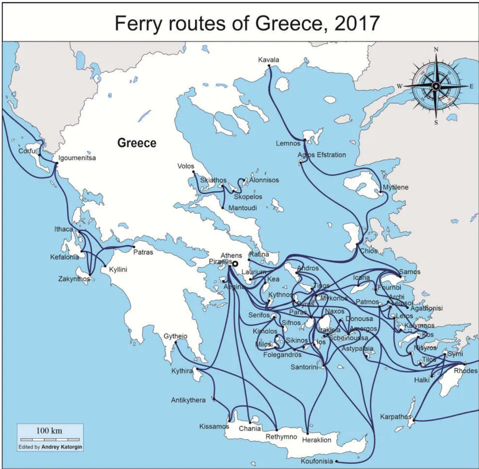
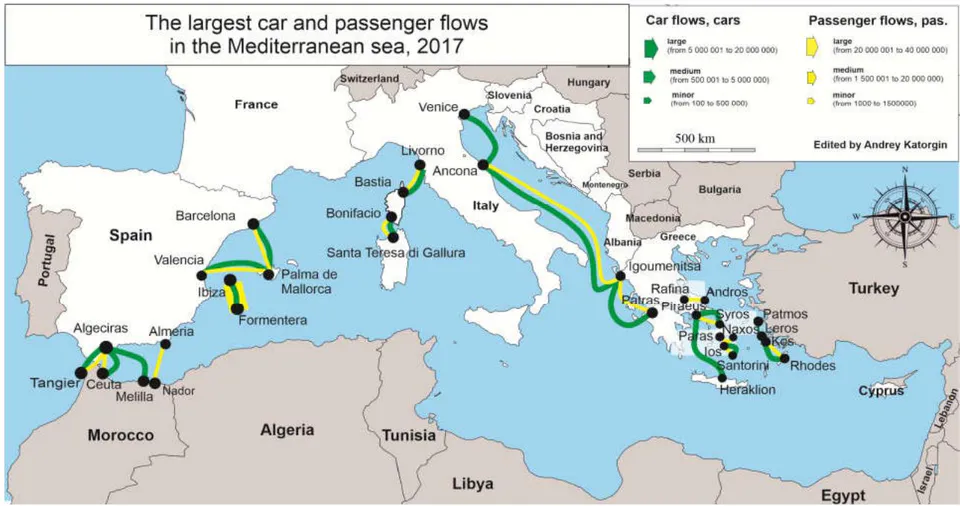
Isolated ferry systems have also developed in the west, where the largest ports are Igoumenitsa, Patras and Killini (Fig. 1). These ports provide routes to Zakynthos (Killini), Kefalonia (Killini and Patras), Ithaca (Patras), Corfu (Patras and Igoumenitsa) and Italy. Most international routes of Greece link the country to Italian cities. There are also routes between the islands of the Aegean Sea and the resort towns of Turkey. Despite the regularity of such international departures is much lower than domestic ones, car and passengers traffic here is
the highest in Greece. The Venice-Ancona-Igoumenitsa-Patras corridor serves as a quick and cheap means of travel for cross-commuters from Greece and Turkey. Most Turkish migrants, who work not only in Italy, but also in other European countries, are transported annually along the corridors. At the same time, Greek residents are also a part of the migration flows due to the weak social and economic development of the western regions of Greece: for the majority of local residents it is vital to travel to Italy to earn for living.
Ferry services in Greece are seasonal: their regularity decreases from January to March due to general unfavorable weather conditions. The Greek fleet contains of more than 120 vessels, but most of them are worn out and has a small capacity. At the same time, the sea ferry service of Greece can be characterized as a «bus-type» system: ferries do not usually run vice versa from one port to another, but along the long linear route passing through several islands, making stops on each of them (as a bus). Often it takes a whole day to cross the route and a ferry returns only for the next day. This is unique, as it is only found in Greece throughout Europe.
Greece has a bipolar ferry system. It is divided into two seas: ionic and Aegean. While the ionic sea is characterized by international traffic (with Italy), the Aegean sea is connected to remote Greek islands, many of which are major tourist destinations. In general, the country is characterized by a predominance of domestic transport over external transport. The largest flows (both passenger and car) are from the metropolitan region (the port of Piraeus) to the largest islands (including Crete) and to Italy as well.
IV. ITALY, MALTA, CROATIA, MONTENEGRO
Due to the physico-geographical features of the Apennine Peninsula (extended from north-west to southeast, bordered by the narrow Adriatic Seain the east, most of the island territories of Italy are to the west from the peninsula) the Italian maritime ferry system is divided into two zones.
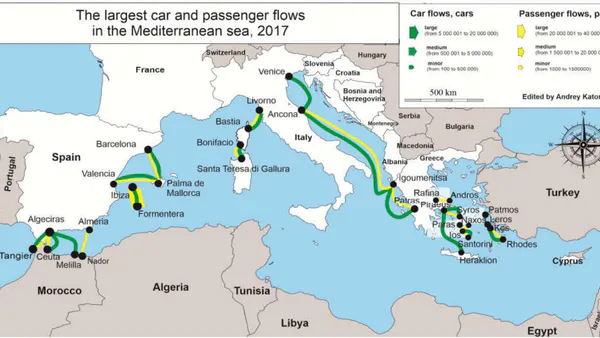
The first is located in the Adriatic Sea, which is dominated by long short-sea routes (connecting Venice and Ancona in the North with Bari and Brindisi in the South), allowing the most efficient communication between the northern regions of the country, where the main production facilities are located, with the southern regions, which are the main consumers of goods produced in the North. In addition, international transport is important for the Adriatic Zone. Ankona-lgoumenitsa is the busiest route of the country (the volume of passenger traffic on the route exceeds 3.5 million people per year, and the volume of car traffic is about 1.5 million cars per year, 2017). The routes from Brindisi to Patras and Igoumenitsu, as well as the Ancona-lgoumenitsa route, were established due to the commuters from Turkey and Greece demand for ferry transportation. There are also ferry links to Croatia and Montenegro. However, there are only two regular routes (Bari - Bar and Ankona - Stary Grad). But still these routes are seasonal because of the tourist demand only during the «high season». Passenger and car flows' volumes are categorized as minorfor these directions (Fig. 2.)
The second zone covers the waters of the Tyrrhenian Sea, where traffic between the Apennine Peninsula and the largest islands of the region - Sicily,
Sardinia and Corsica is concentrated. A lot of ferry lines of equal density connect not only the islands mentioned above, but Italy to Spain as well (ferries from Savona,
Livorno, Salerno and Cagliari to Barcelona and Valencia). However, the largest volume of flows in that zone is reached on the lines connecting Sardinia andCorsica with the Apennine Peninsula. Thus, passenger traffic on the route Santa Teresa-Gallura (Sardinia)- Bastia (Corsica) exceeds 3 million people per year (2017), and car traffic is approaching 1 million cars per year (2017).
In addition to all the links above, a number of ferry flows are focused from Italy to Malta. There are four low-busy routes from Salerno, Catania, Genoa and Livorno. Besides, Livorno is the attraction center for the most of the Italian ferry flows. Due to its developed infrastructure it is the final destination port on ferry routes from Montenegro, Malta, Spain and France.
V. SPAIN, FRANCE, PORTUGAL
The physical geography of France and Spain is similar in many points. Both countries have access to both the Atlantic Ocean and the Mediterranean Sea. However, in the Mediterranean water area there are island territories of the neighboring countries which lead to necessity to maintain permanent transport links.
France's maritime ferry services in the region are dominated by intercountry transportations dew to the large flows to Sardinia (Santa Teresa Gallura; described earlier) and the Peninsula of Apennine (Livorno). The connection is organized via symmetrically located ports of Bastia in the north of Corsica and Bonifacio in the south. Intercountry connections (to mainland France) are dominated by the number of lines, but not by their congestion. Ferries go to Corsica from Marseille, Toulon and Nice.
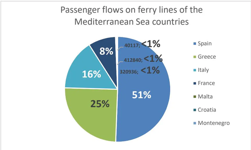
Concerning Spain, the Balearic Islands are the main center of attraction for ferry traffic. Here the largest flows are concentrated (not only in Spain, but in the entire Mediterranean Sea). The largest passenger traffic in Spain and the Mediterranean area as well is on the Formentera-Ibizaline (over 23 million passengers per year (2017)).
This is due to the continuously developing tourism on Formentera with its beautiful white sands and pines on the shore in SantFerran, while there is a thin strip of wild terrain with two quiet beaches on the west. The island of Formentera is considered to be one of the best places for beach holidays in the Mediterranean. There is no developed tourist infrastructure on the island, as the main advantage of its beaches is solitude on the coast of the green turquoise sea.
The green turquoise color of the Formentera shore waters is due to the 40-metre deep grasslands of Posidonia. This underwater plant provides shelter and food to a huge number of sea creatures. That is why UNESCO has declared a colony of Posidonia near Formentera a biosphere reserve, and the island itself with its waters - a monument of the World Heritage of
Mankind/ That unique status attracts a lot of divers to the island.
The largest car traffic in the Mediterranean Sea is also concentrated between the Balearic Islands. The Barcelona-Palma de Mallorca route annually transports about 2 million vehicles. The high recreational attraction of Mallorca Island requires a continuous and uninterrupted supply of food and related goods. Even drinking water is imported to the island from the mainland, as there is no enough fresh water to sustain the local population, not taking into account a growing number of tourists.
The very intensive ferry service can be observed in the Strait of Gibraltar. Both passenger and car flows are medium and are generated by travelers from Spain to Morocco. Departures are made from the ports of Algeciras and Almeria to the Moroccan ports of Tangier, Melilla and Nador. The Algeciras-Ceuta route is an outstanding line because it is not formed by tourists but by Spanish exclaves citizens on the northern coast of Africa.
Concerning Portugal, despite its geographical proximity to the Mediterranean Sea, ferry services tend to be concentrated on Western and Northern Europe. From Portuguese port of Leixões ferries depart to Dublin and to German ports of the North Sea, so the flows in these directions were not studied.
VI. CONCLUSION
The maritime ferry system in the Mediterranean Sea is divided into several separate zones. The system can be called bipolar with the main attraction regions of Greek and Spanish islands, located in different parts of the Mediterranean Sea (Fig. 3).
The busiest destinations in the region connect mainland Spain with the Balearic Islands (Formentera-Ilbiza and Barcelona-Palma de Mallorca), while the largest number of minor flows are between the islands of Greece. At the same time these Greek routes are unique for entire Europe and can be called «bus type routes».
The passenger ferry traffic, which had previously prevailed in the region, is no longer dominant and is gradually being replaced by freight traffic. In the Mediterranean, long ferry lines link Spain with Italy and Greece. At the same time, the Mediterranean ferry service continues to be isolated from the waters of the North Sea and the Baltic Sea. Integration of different maritime areas may be facilitated by the extension of routes from Portugal (the port of Leixoines is linked by ferry lines to Ireland and Germany) to Mediterranean ports (to Spanish Algeciras or Almeria, for example).