
I. INTRODUCTION
The Sahel experienced two chronic droughts in 1972-1973 and 1983-1984, leading to ecological imbalance (Le Barbé and Lebel, 1997; Lebel and Ali, 2009; Nicholson, 2013). Besides compromising production systems, these drought events made the populations of the Sahelian region vulnerable (Karambiri and Gansaonré, 2023). Although some studies suggest a trend towards more abundant rainfall (Karambiri and
Gansaonré, 2023) and greening (Seaquist et al., 2009; Bégué et al., 2011; Bagganian et al., 2021), the current observation reveals an evolving dynamic of vegetation cover in the forest ecosystems of certain Sahelian countries (Sangaré et al., 2020 in Mali; Tiamiyu et al., 2023 in Burkina Faso; Aboubacar et al., 2023 in Niger).
These three countries, sharing similar climatic realities, also face an unprecedented security crisis threatening their territorial integrity. Under comparable geopolitical conditions and navigating the same political contexts, they decided to pool their efforts through the creation of the AES (Alliance of Sahel States). This organization, aiming to defend the territorial integrity of its member countries, also advocates for their independence and economic development, predominantly driven by rural activities, particularly agriculture and livestock farming (Thomas and Samassekou, 2003; MEEVCC, 2018). These activities heavily rely on natural resources, especially forests. Forests are indeed referred to as a "giant sponge" (CIFOR, 2012), absorbing water during rainy seasons and redistributing it during drought periods, benefiting sectors such as agriculture and livestock farming (Tiamiyu, 2023). Forests also contribute to improving and/or maintaining soil fertility by protecting against erosion, thereby enhancing agricultural yields. Beyond the significance of forests for agricultural and pastoral sectors, forests have socio-economic and environmental importance unanimously acknowledged by scientists. Socioeconomically, forests serve as a source of food and income for populations, providing edible products such as fruits, seeds, and leaves of forest species used in their diet. Some of these products are processed and/or traded, constituting a significant source of income for many rural households. In Burkina Faso, Tiamiyu (2020) and Yanogo et al. (2023) revealed that a large portion of the population, especially in rural areas, derives their livelihood directly from natural resources, including forest resources. For the Burkinabe state, forest resources, through only timber products, contribute to of GDP, while activities related to non-timber forest products generated over 25 billion CFA francs in 2008 (MEDD, 2012). In Mali, the forestry sector, through timber products, contributes to GDP and accounts for of export products. The trade of wood fuels generates a turnover of 21 billions CFA francs annually (https://www.fao.org/3/ab571f/AB571F05.htm). Beyond the revenues generated by this sector, it provides employment for both rural and urban populations, with the FAO estimating over 400,000 temporary or permanent jobs created by this sector for Malians (https://www.fao.org/3/ab571f/AB571F05.htm). In Niger, woody species from forest ecosystems are highly sought after by the population, serving as the primary source of income, medicinal products, food, energy, and materials essential for the production of everyday items (Abdou Habou et al., 2020). Forests also harbor plant species whose parts are harvested for medicinal recipes for the curative or preventive treatment of certain diseases. Tiamiyu (2023) highlighted the harvesting of roots, leaves, seeds, and bark of forest species for the treatment of diseases such as diarrhea, body aches, abdominal pains, malaria, and cough. On the environmental front, forests contribute to improving and/or maintaining soil fertility by protecting against soil erosion in watershed management and desertification control efforts (Thomas and Samassekou, 2003). They also constitute excellent biotopes for the flourishing of a diversity of plant and animal species.
However, the forest ecosystems of these three countries are continually marked by degradation due to climatic precariousness and human activities. Numerous studies conducted across the AES countries have highlighted the spatiotemporal dynamics of these ecosystems, revealed the determinants of this dynamics, and modeled the evolution of vegetation cover in these ecosystems. The synthesis and dissemination of the results of these studies constitute a major step in diagnosing the dynamics of vegetation cover in forest spaces and understanding the determinants for the development of a common strategy to promote forest ecosystems. The aim is not only to understand the dynamics of vegetation cover in the forest ecosystems of the AES region, but also, and above all, to analyze the factors. Thus, what is the dynamics of vegetation cover in the forest ecosystems of the AES region? What are the factors involved? The ultimate goal of this study is to harmonize endogenous strategies for promoting forest spaces through the sharing of successful examples.
a) The Geographical Space of the Study
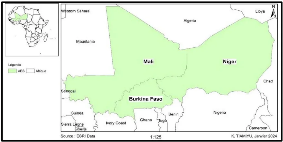
The geographical scope of the present study is the AES (Alliance of Sahel States) region, formed by Burkina Faso, Mali, and Niger. It is bordered to the North by Algeria, to the Northeast by Libya, to the East by Chad, to the South by the Republics of Nigeria, Benin, Togo, and Côte d'lvoire, to the Southwest by Guinea Conakry, and to the West by Senegal and Mauritania (Figure 1). All landlocked countries, Burkina Faso, Mali, and Niger are located in the Sahelian belt, covering respective areas of , , and . They have respective populations of 20,505,155 inhabitants (INSD, 2022), 22,395,485 inhabitants (INSTAT, 2023 https://rgph5.instat-mali.com/site/), and 23,591,983 inhabitants. The AES thus covers a total area of 2,781,390 with a total estimated population of 66,492,623 inhabitants.
In terms of climate, the AES is influenced by a dry tropical climate in Burkina Faso, a Sudanian-Sahelian climate in Mali, and a Sahelian continental climate in Niger, all characterized by two seasons, with a dry season lasting longer than the rainy season. The annual average rainfall varies between 175 mm and 1,066.66 mm, from less rainy to more rainy areas.
Regarding vegetation, the AES is composed of steppe, savanna, and forest formations. The forested area of this space is estimated at 19,343,000 ha, with 5,649,000 ha in Burkina Faso, 12,490,000 ha in Mali, and 1,204,000 ha in Niger, according to the regional report on the assessment of forest resources in the ECOWAS (Economic Community of West African States) region (Ngom, 2015), representing a forest cover of of the total area.
b) Research Methodology
This study relied primarily on secondary data gathered from scientific publications across all categories. A thematic reading sheet was designed for this purpose, enabling the identification of relevant documents whose analysis led to the results presented in this study.
c) Identification of Documents
Documentary research was primarily conducted in virtual scientific databases such as ResearchGate, Academia, Google Scholar, and in the archives of scientific journals, including the International Journal of Biological and Chemical Sciences, Ecosystems and Landscapes, Africa Sciences, Revue Marocaine des Sciences Agronomiques et Vétérinaires, among others. In addition to these virtual documentation centers, the libraries of Norbert ZONGO University and Joseph KI-ZERBO were consulted. The themes guiding this documentary research included "dynamics of forest ecosystems," "factors influencing the evolution of vegetation cover in forested areas," "human and forest," and "dynamics of land use in forested areas." Keywords such as "vegetation formation," "anthropogenic actions," "climate variability," "Burkina Faso," "Mali," and "Niger" were used to refine the search. This resulted in the compilation of a document corpus consisting of scientific articles, doctoral theses, research papers, and work reports.
d) Analysis of Documents
This analysis focused on four elements: the nature of the identified documents, the study area, the methodology used, and the addressed themes.
II. RESULTS
a) Nature of the Documents Used
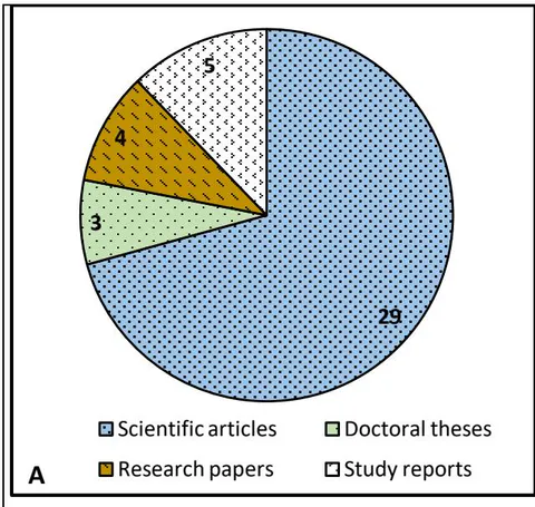
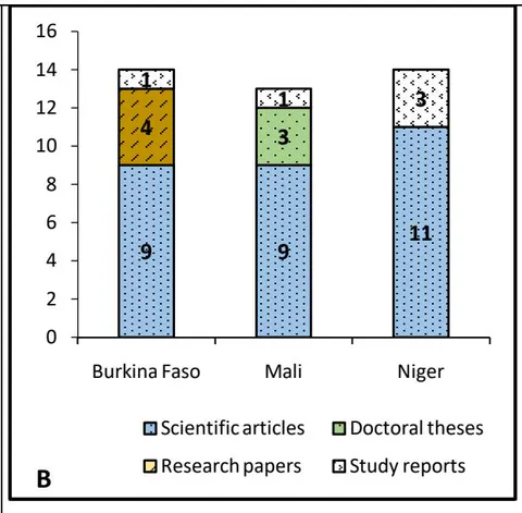
A corpus of 93 documents addressing the theme in one of the three countries of the AES was identified. The criterion of the year of publication prior to 1972, the year marking the beginning of the chronic drought that struck the Sahel, led to the elimination of 52 documents, leaving only 41 documents retained. These documents are of diverse nature, including scientific articles, doctoral theses, research papers, and study reports (Figure 2).
Source: Laboratory work
Figure 2 illustrates, through its section 'A,' that the documentary range used in this study is predominantly dominated by scientific articles. In section 'B,' this figure highlights the nature of the documents used by country.
b) Methodology Adopted
The studied documents primarily adopted two methods to highlight the dynamics of vegetation cover in the studied forested areas. The first method is based on the diachronic analysis of satellite images using remote sensing and GIS coupled with field data and questionnaire surveys (peasant perception). It allows for the identification and clear description of the various land use zones in a specific ecosystem (Betbeder, 2015). It also helps to understand how vegetation cover evolves over time, the rate of change between different periods, and the transformations of the different land use zones. However, it does not take into account the knowledge of farmers on the subject. The second approach, based on questionnaire surveys addressing farmers' perceptions, is used by of these documents. It has the advantage of placing the endogenous knowledge of the studied phenomenon at the heart of the study. The remaining of the documentation, composed of reports, utilized secondary data.
In addition to these documents, others addressing the same theme but focusing on different geographical areas from those of the present study were downloaded. These documents served for the discussion of the results of the current research.
c) Determinants of Vegetation Cover Dynamics
The synthesis of the results of the analyzed works reveals a dynamic, sometimes regressive, sometimes progressive, of the vegetation cover in the forest ecosystems of the AES space. Whether progressive or regressive, this dynamic has always been the result of several determinants. The present synthesis highlights two main categories: natural determinants and anthropogenic determinants.
d) Determinants of the Progressive Dynamics of Vegetation Cover in Forested Areas
Gray literature has revealed a positive evolution of vegetation over time in certain locations within the AES countries. This progressive dynamic is mainly linked to human actions. These actions include the practice of assisted natural regeneration, more prevalent in Niger (Baggnian et al., 2021), the organization of reforestation campaigns, and the strengthening of forest area surveillance by local forest management committees in Burkina Faso (Tiamiyu et al., 2023). In addition to these actions, the establishment of nurseries and the production of plants for reforestation campaigns in Mali (Dembélé et al., 2022) contribute to the positive dynamic. Beyond these practices, the variable rainfall, with an evolving tendency at times, somewhat promotes the flourishing of vegetation cover, often leading to a positive dynamic in the area of plant formations in forested spaces (Tougiani et al., 2023).
e) Determinants of the Regressive Dynamics of Vegetation Cover in Forested Areas
Natural Determinants
The natural determinants of the regression of vegetation cover in forested areas are mainly climatic. They are characterized by the recurrence of drought sequences (Soulma et al., 2015), the aggressiveness of heavy rains on the soil (Kaboré, 1999), variations in atmospheric humidity (Ouedraogo, 1992), a decrease in rainfall (Hamidou et al., 2012; Sangaré et al., 2020), the prolongation of dry periods (Kéita et al., 2023), and the increasing aridity of the climate (Diallo et al., 2011).
Although climatic fluctuations negatively impact vegetation cover, humans, through their activities, remain the primary cause of the regressive dynamics of plant formations in the AES space.
- Anthropogenic Determinants
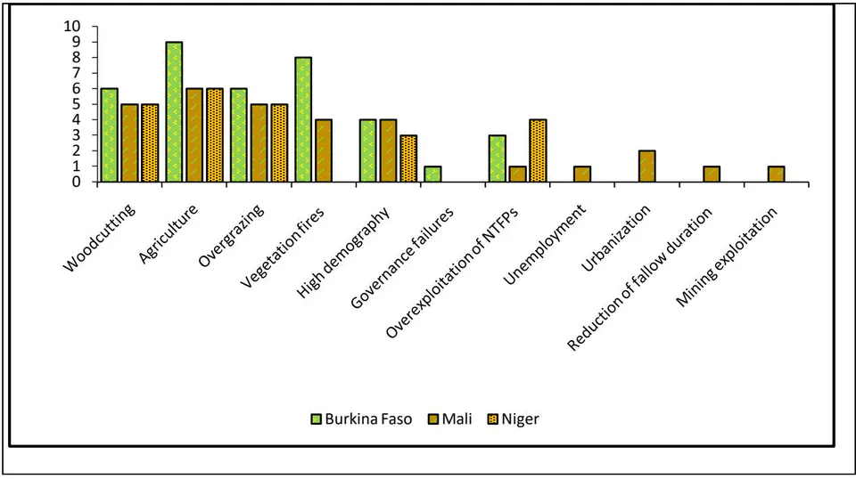
These determinants are related to human actions and activities. In total, eleven (11) determinants have been identified through the consulted documents, with variable citation numbers from one determinant to another and from one country to another (Figure 3).
Source: Laboratory work
Figure 3 categorizes these determinants into three groups:
- Determinants Common to All Three Countries
Woodcutting (Assoumane, 2014)
Agriculture (Mariko, 2003)
Overgrazing (Mamane et al, 2018)
High demography (Saidou and Ambouta, 2020)
Overexploitation of NTFPs (Non-Timber Forest Products)
(Abdou et al., 2019)
- Determinants Common to Two Countries
- Vegetation fires (Burkina Faso and Mali)
- Determinants Specific to Each Country
Governance failures (Tiamiyu et al., 2023) (Burkina Faso)
Unemployment, urbanization (Maiga et al), reduction of fallow duration (Sangaré et al., 2020), and mining exploitation (Traoré et al., 2022) (Mali).
This figure also highlights agriculture as the most dominant, followed respectively by vegetation fires, woodcutting, and overgrazing.
III. DISCUSSION
a) Natural Factors in the Dynamics of Forest Vegetation Cover
i. The impact of climate on vegetation cover
Climate is a key factor that conditions the state and evolution of forest vegetation cover. It influences the dynamics of vegetation cover through precipitation and temperature (V. Djoufack-manetsa, 2011; Jiagho, 2018). A decrease in precipitation and an increase in temperatures compromise the growth and regeneration of woody plants. According to Yonkeu et al., a precipitation deficit negatively affects vegetation cover. When pronounced, this deficit increases the mortality of woody plants, makes natural regeneration difficult, and destroys grasses that are very sensitive to water absence. Sanson and Parde (1951) also argue that a precipitation deficit damages the density of vegetation by harming nurseries intended for reforestation campaigns and by limiting the growth of young seedlings. Thus, precipitation fluctuations weaken the plant biodiversity of tree and shrub layers (Pallo and Sawadogo, 2010).
A constant increase in temperature also deeply disturbs forest cover (GEIEC, 2001). Forest cover stands are destroyed by the recurrence of heatwaves, including the older ones. Prolonged absence of water in the soil leads to the drying of adult subjects (Sanson and Parde, 1951). Conversely, good precipitation promotes a better expression of vegetation cover. Tra Bi et al. (2013) note that wet periods induce significant vegetation cover on the ground. Mahamané et al. (2012) revealed high diversity and productivity indices of vegetation cover in areas with a marked precipitation gradient from South to North in Niger. Pallo and Sawadogo (2010) also argue that relatively abundant precipitation and a mild annual average temperature promote biological diversity in tree and shrub layers. The variability of precipitation significantly influences the photosynthetic activity of plants (Lebrat, 2016). Beyond climate, other natural determinants can influence the vegetation cover of forested areas.
ii. The impact of soil on vegetation cover
The composition and spatial distribution of woody vegetation are influenced by soil types. In a study on the vegetation dynamics in the peripheral zone of Waza National Park in Cameroon, Jiagho (2018) found that the landscape unit dominated by ferruginous soils contains a relatively high specific (36 species) and genetic (29 genera) diversity compared to other landscape units dominated by hydromorphic soils and clayey plains, which have 29 species distributed in 24 genera. The landscape unit dominated by vertic soils, on the other hand, hosts 34 species and 26 genera. According to Cesar (1978) cited by Devineau et al. (1997), sandy-clayey soils would be conducive to the good growth and high density of woody resources. For hydromorphic soils, Devineau et al. (1997) argue that they offer favorable conditions for phorbs to develop comfortably, unlike woody flora and herbaceous strata that flourish less. Argillolimonosandy soils, in turn, favor the development of species in shrubby formations. Deep sandy to sandy-clayey soils, often hydromorphic, ensure significant diversity of woody plants. However, they limit the development of herbaceous plants, which are weakly characterized there. Herbaceous and shrubby strata are remarkably diverse on non-gravelly or shallow soils. Gravelly soils are characterized by the presence of herbaceous and woody species. They support vegetation formations such as wooded savannas or clear forests with diverse woody species.
b) Anthropogenic Factors in the Dynamics of Forest Vegetation Cover
i. Expansion of Agriculture, a Factor Limiting the Flourishing of Vegetative Cover
Agricultural activity alone is responsible for of global deforestation (FAO, 2016). It is the main driver of deforestation, forest cover degradation, and the resulting reduction in forest biodiversity (FAO, 2020). According to Jiagho (2018), extensive agriculture is the most important factor in the degradation dynamics of the flora and woody vegetation in the peripheral zone of Waza National Park in Cameroon. N'guessan et al. (2019) highlighted anthropogenic pressure as an explanatory factor for the regression of vegetation cover in the classified forest of Agbo1 in Benin. For these authors, this anthropogenic pressure is manifested by the expansion of cash and subsistence crop fields. In a similar vein, Houndagba et al., 2007, cited by G. L. Djohy et al. (2016), noted an annual average destruction of vegetation cover estimated at 100,000 ha in 1991 for the benefit of crop fields in Benin. Djohy et al. (2016) also revealed a progressive evolution of crop and fallow units at the expense of vegetation formations in the Sinendé commune between 1990 and 2010. According to these authors, the area of fields and fallow increased from of the study area in 1990 to in 2010. In contrast, the area of vegetation cover, which initially represented of the study site in 1990, occupies only in 2010. They conclude that the regression of vegetation cover is linked to the remarkable expansion of agricultural lands. In Benin, Biaou et al. (2019) note the conversion of a portion of the vegetation cover of the classified forest of Ouénou-Bénou in Northern Benin into mosaics of crops and fallows between 1990 and 2014. Covering only (2998 ha) of the total forest area in 1990, crop fields and fallows represent up to (11,945 ha) in 2014. In the AES region, agriculture is revealed as the main anthropogenic activity causing the degradation of forest ecosystem vegetation cover in the region. Hence, there is a concordance of these different results with those of the present study.
ii. Vegetation Fires: a Factor of Destruction or Vegetative Cover Restoration?
Vegetation fires are often cited as a determinant limiting the expansion of vegetation cover. Practiced by various actors for various reasons, bushfires contribute to the degradation of forest potential. They lead to a reduction in vegetation cover, loss of biodiversity, erosion, and soil leaching by exposing them to erosion agents, as well as an increase in atmospheric temperature (Lompo). They negatively impact productivity and disrupt the floristic composition of forest cover (Kaboré, 1989 and Sawadogo, 2009 cited by MEEVCC, 2018). Jiagho (2018) revealed uncontrolled bushfires as one of the most threatening anthropogenic factors in the degradation of flora and woody vegetation in the peripheral zone of Waza National Park in Cameroon.
The extent of the impact of fire on vegetation cover is not systematic. It depends on the nature of the burned biotope (vegetation cover and its floristic composition) and its frequency (Jaffre et al., 1997). If controlled, they "play an important role in maintaining or modifying the morphology and specific composition of the cover" (Gueguim et al., 2018). However, if they occur frequently, they reduce forests to forest relics (Morat et al., 1981 cited by Jaffre et al., 1997; Louppe et al., 1998). Unlike foresters who have always argued that fire is a destructive factor of vegetation (Louppe et al., 1998), farmers advocate the benefits of fire in the restoration of vegetation cover. For them, burning promotes soil fertility through ash and allows the development of new shoots. In the same vein, Balle et al. (1998) argue that early fires remain a prevention tool to fight against late fires and are used on fertile soils.
They consider them as a forest management tool. However, they acknowledge that it is essential for management actors to understand the behavior of different species towards fire while taking into account the objectives of management for its effectiveness. Ballouche, 2005 cited by Ouattara et al. (2016), supports that fire promotes the flourishing of herbaceous and especially grass species by creating a sufficiently airy space for their development, benefiting from sufficient sunlight. The impact of vegetation fires on vegetation cover should, therefore, be nuanced. In the AES region, vegetation fires are identified as a factor leading to a decline in vegetation cover. Specifically in Burkina Faso and Mali, late fires, often caused by the carelessness of fire users (smokers, hunters) in the vicinity and sometimes within the forest area, consume a significant portion of the vegetation cover.
iii. Overgrazing
Pastoral activity is responsible for approximately of deforestation globally (FAO, 2016). Defined by the FAO as the practice of grazing a high number of animals on land that cannot support the restoration of its vegetation cover for an extended period, overgrazing is a factor in the regression of forest formations (Kéita et al., 2023). It is manifested by increased browsing of forage trees for animal feed and trampling of the soil (Tidjani et al., 2009), hindering the growth of new shoots. This practice is believed to be the cause of of degraded lands according to the FAO. Jiagho (2018) identified extensive pastoralism as one of the practices that contribute to the degradation of flora and woody vegetation in the peripheral zone of Waza National Park in Cameroon. Pastoral activity is also mentioned by Tra Bi et al. (2013) as a factor responsible for the decrease in vegetative mass in the Bouregreg watershed in Morocco. The phenomenon of overgrazing is a reality in the Sahelian region, which is a pastoral area. The three countries in the region, especially Niger, have a significant livestock population that requires a high availability of forage resources. The shortage of forage is compensated for by forest species, which contributes to their degradation. These results are therefore consistent with those of the present study.
iv. Mining Activity
Mining activity leads to the destruction of vegetation cover and exposes the soil to often intense erosion phenomena (Maradan et al, 2011 cited by Bamba et al. 2013; Mesmin et al, 2015). It is responsible for of global forest losses (FAO, 2016). This activity contributes to soil impoverishment through the use of toxic substances (acids, mercury, cyanide) for ore processing and other non-biodegradable solid wastes (Bamba et al. 2013). Once impoverished, the soil, an essential support for terrestrial ecosystems, is no longer able to provide the nutrients necessary for the flourishing of vegetation cover. This has consequences on natural resources in general and forest cover in particular. Mining activity disrupts the forest ecosystem by causing the loss of natural vegetation, wildlife habitat, and biological diversity, as well as soil and vegetation cover degradation (Ouedraogo). This activity poses a serious threat to forest resources. It is a consumer of wood, with cutting occurring in two stages: clearing for the temporary development of the mining site, including the installation of various actors in the chain, and cutting wood for site expansion. Wood is also used as supports or poles in mining shafts. The high human concentration around mining sites puts strong pressure on trees, which are cut for use as an energy source (Cissé, 2019; Messina, 2014). All of this contributes to exacerbating deforestation. In Mali, mining is cited as a factor in the degradation of vegetation cover in forest formations.
IV. CONCLUSION
The vegetation cover of forest ecosystems in the AES region is significantly disturbed by anthropogenic factors, prioritized in order of importance as agriculture, vegetation fires, logging, and overgrazing. Alongside these factors, there are practices that contribute to the protection and improvement of vegetation cover in these ecosystems: the effectiveness of local forest management committees, the practice of assisted natural regeneration, the establishment of nurseries, and the production of plans for reforestation campaigns. The identification of the main anthropogenic factors of degradation and effective management practices represents a significant step in the development of an endogenous strategy for the protection of forest ecosystems. It indeed helps to inform policy decisions aimed at conserving and restoring forest ecosystems in the AES region. Therefore, policymakers, communal authorities, and all stakeholders must prioritize the adoption and dissemination of these practices in the AES area for more sustainable management of forest ecosystems in the region.