Starting from the assertion that vitality can be promoted by morphological elements, the article focuses on the significance of understanding these relationships for the urban security. The research aims to develop an original methodological essay in different scalar approaches of the Cidade Industrial de Curitiba (CIC) neighborhood in the state capital of Paraná, Brazil. The study began with spatial syntax on a macroscale (CIC) associating road axes integration with crime spots, resulting in the selection of four analysis points on the microscale (street). The integration of these two scales as a unique feature of the study. Considering the lot frontage as a unit of evaluation for interpreting characteristics of public spaces, private areas, temporary conditions, and nighttime scenarios, the answers to the investigative question indicate similar behavior for the parameters of the two latter themes. At the same time, significant connections with criminal activities are found only for the second subject.
## I. INTRODUCTION
The analysis of urban vitality from the potential of elements induced by morphological configurations of the landscape requires specific methods for identifying relationships between urban parameters that are adjusted more to properties of form than to the social process of occupation and spatial permanence. This study therefore aims to develop original methodological essay in different scalar approaches of the Cidade Industrial de Curitiba (CIC) neighborhood in the state capital of Paraná, Brazil. It is worth noting the relevance of understand the interactions between spatial morphology and public security, especially in a region historically characterized as one of the most violent areas from that Brazilian city (SESP-PR, 2023).
The territory of the CIC neighborhood encompasses almost $32\mathrm{km}^2$, corresponding to about $10\%$ of the Curitiba space and housing nearly 200,000 people in approximately 60,000 households, which also represents roughly a tenth of the city's total dwellings. With average income levels concentrated between one and two salaries, its economic establishments are primarily oriented towards industry, commerce, and services (IBGE, 2022; IPPUC, 2023).
The answers to the investigative question about which variables for vitality have more relevant relationships between landscape and security of cities seek at testing the guiding hypothesis that some have more influences in these situations. To apply specific criteria for indicating variables of spatial vitality potential on the macroscale (neighborhood: urban route integration) and microscale (street: public spaces, private areas, temporary conditions, and nighttime scenarios) for scenarios during the day and night in the landscape of the selected study area, locations that present different social dynamics and are also sites of criminal activity are identified.
Worthy emphasizing that morphological approach adds value to the understanding of urban security. Thus, it is assumed that "empty" spaces, where there are few social interactions between private and public realms, and among users, are more susceptible to the occurrence of crimes. In this way, it is possible to infer that the cities' vitality, understood as the spatial quality of attracting citizens to a specific location (Koury, 2015), is a fundamental criterion for examining the interaction between morphology and criminality.
It is generally agreed that vitalized localities with more people and more intense relationships with private areas are effective promoting of safe environments (Liu & Guo, 2023; Pakoz et al., 2022). However, crowded areas can be conducive to the incidence of crimes of opportunity (Lee, 2023; Putra et al., 2023).
It is worth mentioning that the present study is based on various theoretical-conceptual and practical-empirical precedents regarding morphology and security in cities to define its methodological procedures and analytical variables. However, it differs from the general knowledge produced in these fields by grounding these themes in conditions of urban vitality, which can then be understood as a link between spatial forms and public safety. This last one is still interpreted as a police problem, however or as a social issue (Ezzeddine et al., 2023). Despite being intrinsically related to the urban condition, few studies analyze it from a morphological approach.
The issue of the relationship between urban space and crime is essential because it is naturally considered as resistant to vitality. The scarcity of studies analyzing urban vitality from a morphological perspective represents a scientific gap that this research aims to address, highlighting the novelty and relevance of the developed methodological essay. Furthermore, violent acts in public places are a feature of the CIC neighborhood (SESP-PR, 2023) and its distinct urban fabric configuration, with the particular pattern of occupation of the area seeming to reinforce such behavior. This requires specific procedures for the research development, which are summarized below.
## II. METHODOLOGICAL OUTLINES
This investigation was based on exploratory, descriptive, and analytical methods. Four approaches were adopted as basic principles. The first - geographic-spatial, corresponds to the CIC neighborhood (Figure 1) given this location's complex characteristics of spatial occupation.
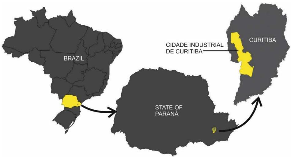 Sources: Based on IBGE (2023) and IPPUC (2023) Figure 1: Maps of the Geographic-Spatial Framework of the Study Area at National, State, and Municipal Levels
The second - historical-temporal, considers the area's configuration, resulting from occupation spread that has produced a fragmented fabric, connected by some higher-status streets used for circulation and commerce, and shaped by continuities and discontinuities in the urban fabric, with significant variations in levels of neighborhood integration on a macroscale fundamental to the research.
The third - thematic-conceptual, relates to the central subjects of the investigation: landscape, vitality, and crime, while the fourth - analytical-scalar, is associated with the macro and micro scales of interpretation of components of the urban landscape.
The study was developed using techniques of direct observation, geoprocessing, spatial syntax, and relational analysis, whose methodological procedures and theoretical foundations are detailed in the subsequent sections.
## III. MACROSCALE RESULTS
Given the broad dimensions and complex characteristics of the CIC, it was necessary to identify significant segments of the area in terms of potential for generating vitality. This identification was based on principles of spatial syntax, aimed at analyzing the relationships between space and society (Hillier & Hanson, 2009[1984]; Mohamed & Yamu, 2023), and integrating occupation patterns with the urban form itself.
Mohamed and Yamu (2023) clarify that space syntax is a theory and method for understanding the social logic of cities. It interprets the level of connectedness and analyzes how the configuration of the street network predicts the intensity of local usage patterns, such as movement flows. This arrangement explains the impacts of urban design on human behaviour. The methodology was used in the present research to seek out the streets most inclined to vitality due to their high level of integration in the neighborhood's urban fabric.
The axial lines of the CIC road network and adjacent neighborhoods were drawn with the aid of the DepthMapX program by importing the street map and its automatic conversion into a mapping of axes classified by degrees of connectivity. These procedures were associated with the qGIS platform, seeking those of greater local importance and limiting the number of topological steps used by the software to the extent of the defined section. Spatial syntax indicated this by the variable of road axis integration intensity, that is, how much the street is potentially used as a connecting element in the many possible routes within the neighborhood (Figure 2). At the same time, the crime spots in this region were mapped by the Onde Fui Roubado (OFR, 2018), filtering data related to opportunity crimes (especially theft and robbery) in the public spaces.
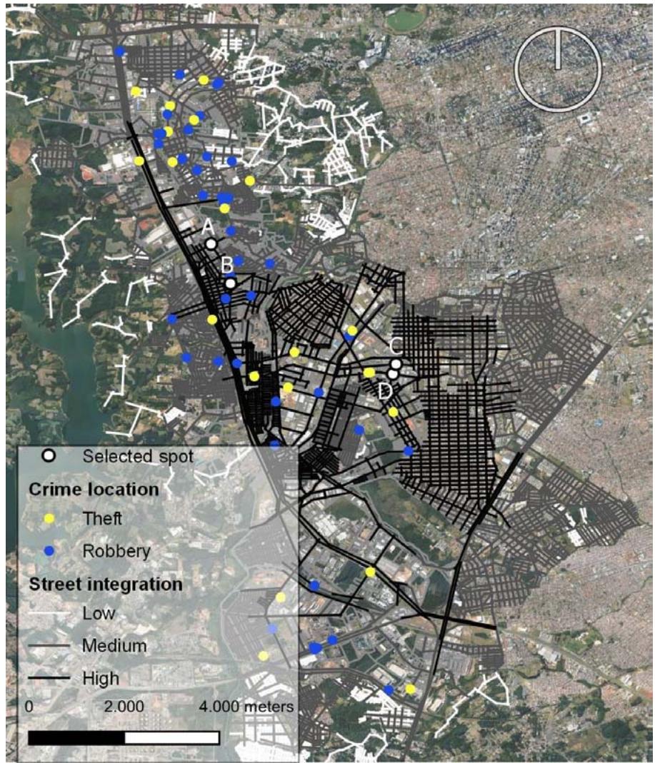 Figure 2: Classification Map of the Macroscale Variable - Street Integration[^1] - in the Cidade Industrial de Curitiba (CIC) Neighborhood and Vicinities, with Theft and Robbery Locations
Note: ${}^{1}$ = developed with the DepthMapX program,associated with the qGIS platform
Source: Based on Google Earth (2023) and OFR (2018)
The OFR platform was active nationwide from 2013 until it was discontinued in early 2019. Among other reasons, the option to utilize this information is justified by the outbreak of coronavirus disease (Covid-19) pandemic, which had substantial effects on contemporary cities (Vinodrai & Brasil, 2023). Potential limitations or biases introduced by using data from a repository that ceased operation were minimized through data reconciliation with available recent official information (SESP-PR, 2023).
It is also worth remembering that the main character of this work is a methodological essay. Therefore, the adopted time frame, and the used source data are not necessarily essential the essayistic analysis.
The CIC district has just over 100 mapped crime cases. The user fills in event data with information such as date, time, type of incident, and brief description. After filtering for completion inconsistencies or lack of information, 75 points were considered valid for the search.
The user entering crime information on the website can select one of seven available types (theft, robbery, group robbery, vehicular burglary, home burglary, commercial burglary, and attempted robbery). These options cover incidents that target both public spaces and private areas. As the research is focused on situations occurring in an outdoor environment, only those pertinent to this situation were chosen.
In Brazilian criminal law, both theft and robbery or burglary are acts aimed at taking something from other people. The last one is accompanied by violence or threat, which reduces the possibility of resistance (Brasil, 1940). The assault itself is not classified as this type of crime in this legislation.
This study, therefore, uses only the terms "theft" (including vehicular burglary) and "robbery".
(enuvessing group and vehicular robberies) as elements of analysis. Let it be emphasized that there is a similar understanding of these offenses in a large part of the other countries.
These outdoor incidents are particularly relevant to the research's focus on spatial morphology and vitality given the intention to provide support for public policies related to urban planning and security measures public policies.
In this classification, the neighborhood has 29 incidents of theft and 46 of robbery reported on the website. Crimes involving violence or threat to the victim predominate. They generally exploit opportunities generated by concentrations of people rather than the possibility of accosting the individual without being caught by others.
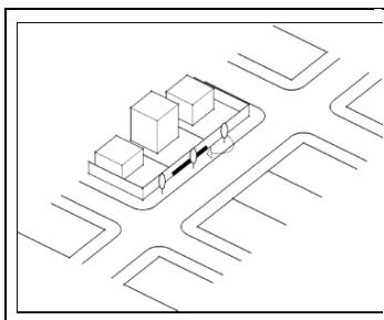
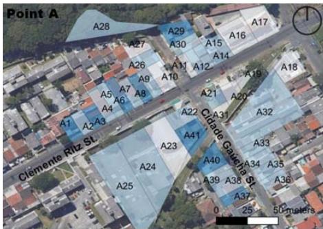
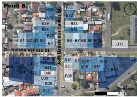
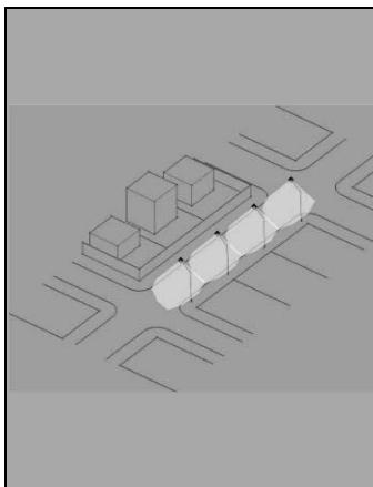
Evaluation of street integration information and crime-spot location together, represented in Figure 3, resulted in selection of four places of interest, which have both high levels of integration and at least one incidence of crime.
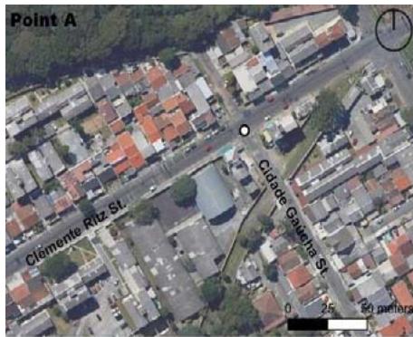
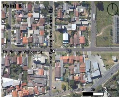
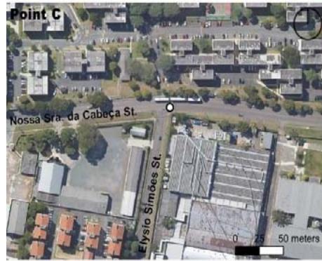
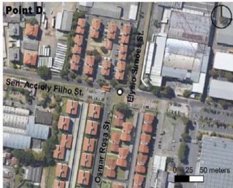 Figure 3: Location Maps of the Points Selected for Microscale Analysis
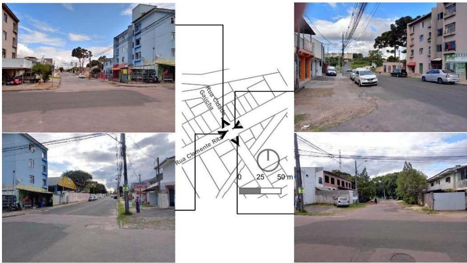
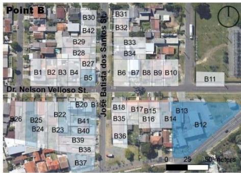
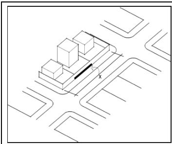
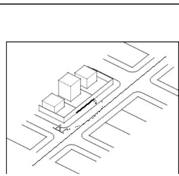
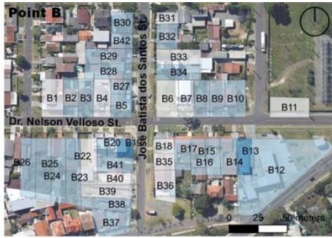
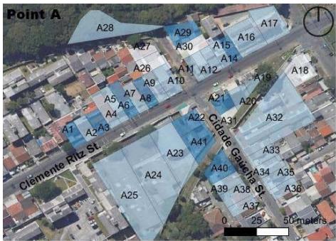
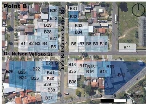
Legend Crime location Source: Based on field surveys, Google Earth (2023) and OFR (2018) In terms of the four selected points, different characteristics are noted for the surroundings of A (armed robbery at night) and B (vehicle theft at night) (Figures 4 and 5), whose urban fabric is more homogeneous and continuous, with many street intersections due to collective industrial and residential uses, producing fewer street intersections.
 Source: Based on field surveys
Figure 4: Views of the Point A
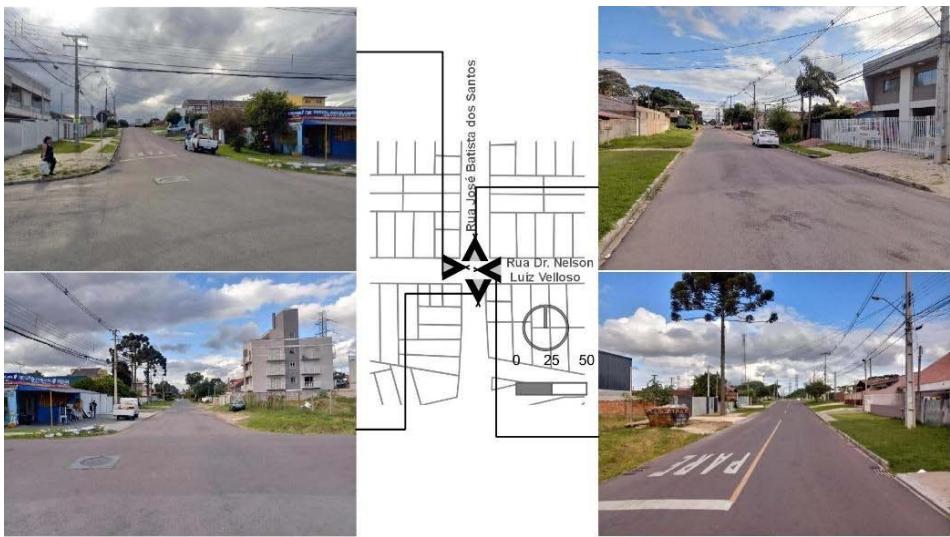 Figure 5: Views of the Point B
Source: Based on field surveys
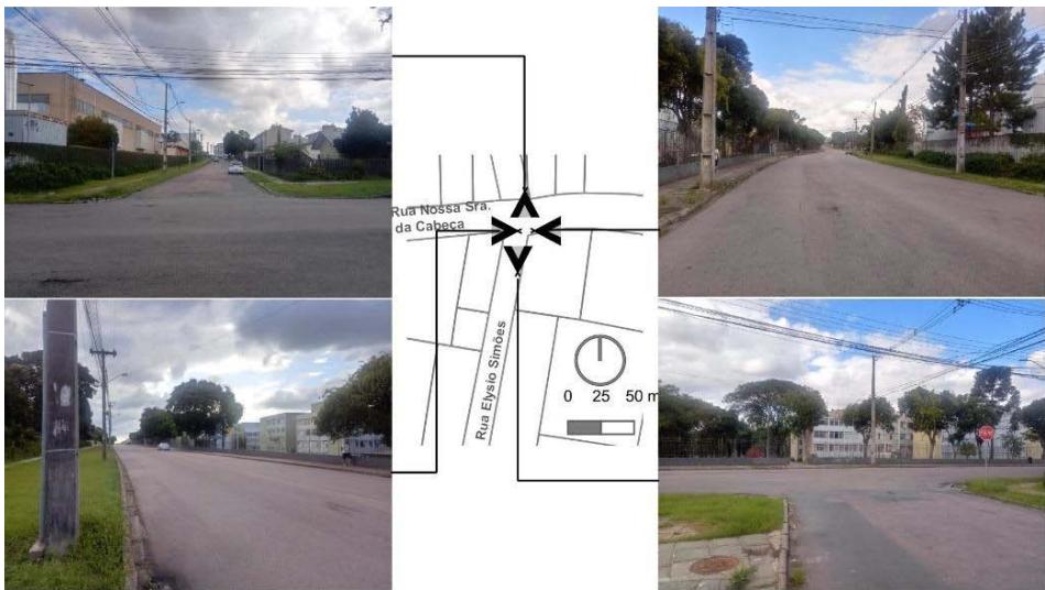
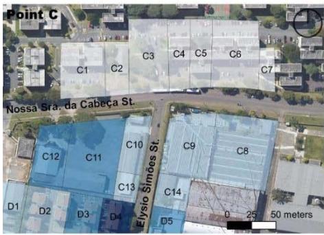
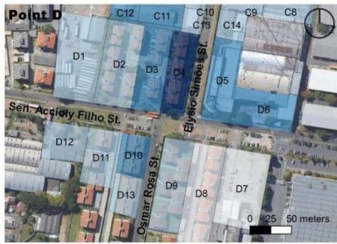
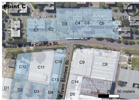
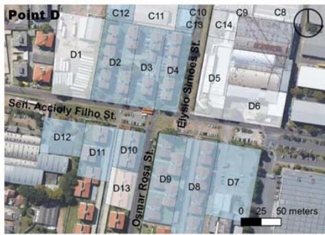
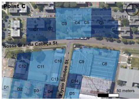
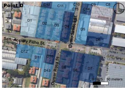
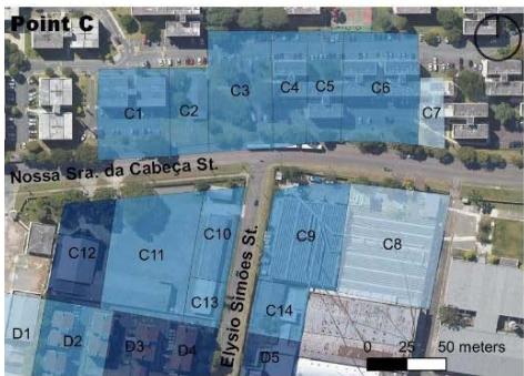
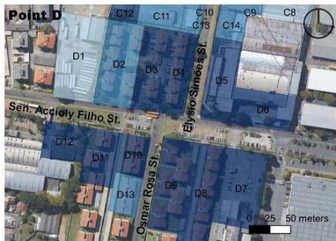
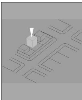
Point C (robbery leaving school in the afternoon) (Figure 6) has a strong residential character, especially in the condominium form, together with industrial use, with vegetation in different strata. In turn, the surrounding landscape of D (theft inside a vehicle during the early morning hours) (Figure 7) is composed of housing buildings of up to four floors, with a dominant presence of extensive walls.
 Source: Based on Field Surveys
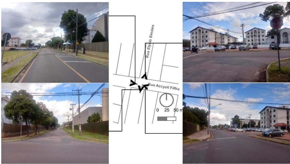 Figure 6: Views of the Point C Source: Based on field surveys
Identification of the places of interest in the macroscale analysis is followed by focusing the research on the nature of each one's potential for urban vitality on a higher scale, based on the location's landscape conditions at a similar time to that of the crime incident.
## IV. MICROSCALE RESULTS
In this approach, elements associated with public spaces and private areas are evaluated individually, together with their temporary conditions and specific nighttime issues. Due to the fundamental role of land division in the application of this methodology, lot frontage is used as the evaluation unit, specifically chosen because it is an easily recognizable entity, and its morphological characteristics relate to the analysis of vitality.
The area covered by the survey comprises 50 m on each side of the crime scene. As these sites are close to corners, the cross streets are also entered in the analysis, using the same defining distance. The total length of 100 m is explained as the measurement of a standard block extent resulting from the parameters established by current urban legislation and justifies the inclusion of intersections within this measure.
Several lots in the study section already showed new subdivisions, with various types of occupation. Therefore, it was necessary to supplement the registry provided by the municipality through field surveys and interpretation of aerial images, considering local landscape conditions. This process minimized the limitations of the outdated data for improvement of the study.
A total of 110 lots was established (points: A = 41, with only $4.9\%$ having an area greater than $1,000 \mathrm{~m}^2$;
B = 42, with only $2.4\%$ in the same situation; C = 14, with most of larger scale - $85.7\%$; D = 13, with all lots of larger dimensions). The geoprocessing procedures also allowed quali-quantitative analysis, based on selected criteria set out in subsequent sub-items. The classification into low, medium-low, medium-high, and high categories was done according to four intervals of scores for each of the four themes defined (public spaces, private areas, temporary conditions, and nighttime scenarios), as presented below.
### a) Public Spaces
The street is a quintessentially public space that articulates the relationships between the private and the common, which makes it the ideal research object. So the seven specific variables studied here characterize the street morphology (Figure 8).
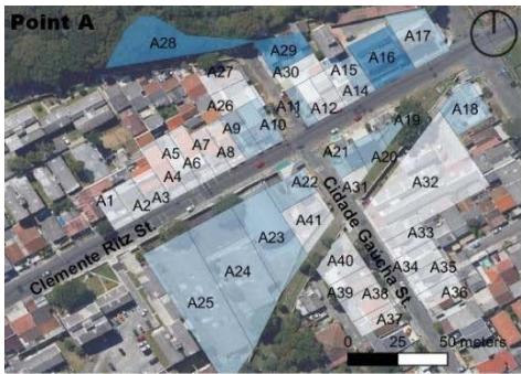 Figure 7: Views of the Point D
 Source: Based On Field Surveys, ABNT (2020[1983]), Google Earth (2023), and IPPUC (2023) Figure 8: Classification Maps of Specific Variables at the Analysis Points of Public Spaces on the Microscale
Measurement of the effects of topography (Table 1) in the study area used an official base of equidistant contour lines (IPPUC, 2023) from meter to meter on a scale of 1:2,000. Interpolation with each road axis enabled identification of the angle for assigning a slope to the lot frontage. The levels were established based on the Brazilian accessibility standard (NBR 9050 - ABNT, 2020[1983]). Road spaces at all four points are shown to have slopes of less than $5\%$, indicating conditions of ease of movement and visual range of passers-by and their environmental perception (Lynch, 2011[1960]; Ho & Au, 2021).
Table 1: Description and Scoring Classes of Morphological Components of Microscale Public Spaces: Topography
<table><tr><td rowspan="3">Average slope of the analyzed stretch of street in front of the lot, obtained through analysis in a geoprocessing environment of the terrain profile</td><td>3 Street in front of the lot with a slope less than 5%</td></tr><tr><td>2 Street in front of the lot with a slope between 5% and 8.33%</td></tr><tr><td>1 Street in front of the lot with a slope above 8.33%</td></tr></table>
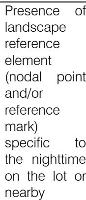
Using Lynch's traditional concepts (2011[1960]) about landmarks and nodal points, the presence of symbolic space (Table 2) near the analysis unit was assessed for quantity and possible adjacencies with the lot under evaluation, given its potential for generating vitality. Except for Point D, all the others have some landscape feature that stands out either for its architectural arrangement or for its symbolism.
Presence of landscape reference element (nodal point and/or reference mark) in the lot or vicinity
<table><tr><td rowspan="3">Presence of
landscape
reference
element (nodal
point and/or
reference mark)
in the lot or
vicinity</td><td>3</td><td>Presence of reference element
in the lot or adjacent to the lot</td></tr><tr><td>2</td><td>Presence of reference element
in the lot block</td></tr><tr><td>1</td><td>No reference element near the
lot</td></tr></table>
Charting the impact of proximity to public transport (Table 3) on vitality is based on the premise that nearby bus stops stimulate people's greater use of the space and their permanence in their surroundings
(Li & Zhao, 2023). But the study points are generally little served by these elements, which are absent from both B and C.
Table 3: Description and Scoring Classes of Morphological Components of Microscale Public Spaces: Proximity to Public Transport
<table><tr><td>Public transport stop in front of the lot or the adjacent lots
Existence of a public transport stop in front of the lot or in its vicinity
2 Public transport stop in the lot block
1 No public transport point near the lot</td></tr></table>
Considering that smaller block size generates more perpendicular routes, offering greater flow possibilities, this item was categorized by main lengths (Table 4) in the study section, demonstrating that different land use and occupation types generate results in the urban fabric. The industrial pattern, with large lots and little feed into the road network therefore brings lower ratings to points C and D than to A and B, suggesting the latter to have more excellent pedestrian circulation, even if it is only passing through. According
to the principles of spatial syntax (Hillier & Hanson, 2009[1984]; Mohamed & Yamu, 2023), fewer route options for individuals tend to discourage local mobility and affect the vitality of spaces.
Table 4: Description and Scoring Classes of Morphological Components of Microscale Public Spaces: Block Size
Relative metric of the length of the lot block, with intervals obtained through the analysis of existing patterns in the location
- 3 Length of block less than 100 m
- 2 Length of block between 100 and $200\mathrm{m}$
1 Block length greater than 200 m
Sidewalk size (Table 5) refers to its width for free and comfortable movement of pedestrians, with an ideal initial parameter of more than $2.00\mathrm{m}$, along the frontage of the unit of analysis. In addition to having no path paving, none of the lots at points A and B are rated at maximum, revealing significant obstacles to universal accessibility (Müller et al., 2023).
Table 5: Description and Scoring Classes of Morphological Components of Microscale Public Spaces: Sidewalk Size
Effective width of the sidewalk in front of the lot and the distance between it and the flow of vehicles
- Free pedestrian lane in front 3 of the lot measuring more than $2.0\mathrm{m}$
- Free pedestrian lane in front of the lot less than $2.0\mathrm{m}$ at some point on the block due to physical obstacles
- Pedestrian traffic in front of the completely obstructed lot 1 at some point in the block, forcing pedestrians to move along the track of vehicles
## Source: Based on foundations of urban morphology and vitality
The presence of vegetation (Table 6) in public spaces was measured according to type. Again, A and B stand out negatively. Indeed, the urban configuration of these areas shows few efforts to use plant elements for microclimate improvement and landscape attractiveness (Bachir et al., 2021; Hu et al., 2023), generating scenarios that are predominantly gray.
Table 6: Description and Scoring Classes of Morphological Components of Microscale Public Spaces: Presence of Vegetation
Presence of vegetation in front of the lot
- Presence of more than one type of vegetation in front of the lot
- 2 Presence of only one type of vegetation in front of the lot
- 1 No vegetation in front of the lot
The existence of urban furniture (Table 7) in public spaces was also evaluated by type, with very poor results for all assessed points. The few evaluation units with higher than minimum scores are those with bus stops in front of them, one of the two types found.
This lack of permanent elements negatively affects potential for spatial vitality due to discomfort and inconvenience for users (Grabiec et al., 2022).
Table 7: Description and Scoring Classes of Morphological Components of Microscale Public Spaces: Existence of Urban Furniture
<table><tr><td rowspan="3">Presence of furniture elements, such as banks,emptizers,buses stops and others, in front of the lot</td><td>3</td><td>Presence of more than one type of furniture in front of the lot</td></tr><tr><td>2</td><td>Presence of one type of furniture in front of the lot</td></tr><tr><td>1</td><td>No element of urban furniture in front of the lot</td></tr></table>
In synthesis, the set of specific variables related to public spaces, compared to private spaces, is more able to affect vitality potential, with predominantly low and medium classification for all points (see Figure 8 in this section). A, B, and C stand out as having no unit of analysis classified in the upper level, while D has only one (7.7% of the lots).
This situation can be explained by the lack of components for relieving the public space, such as the presence of furniture and vegetation, for which D achieved higher scores. This condition demonstrates the importance of common areas in providing attractive activities that encourage people to remain (Liu & Guo, 2023). These analyses are complemented by the following presentation on buildings owned by parties other than the community.
### b) Private Areas
As a counterpoint to public spaces, these properties were interpreted through the lots facing the evaluated street (Figure 9), involving seven variables of the land occupation criteria and analyses of possible permeabilities between them and sites of use.
 Source: Based on field surveys and Google Earth (2023) Figure 9: Classification Maps of Specific Variables at the Analysis Points of Private Areas on the Microscale
Building height (Table 8) measured the possibility of suitable urban scale from architectural height concerning the street, and subsequently the comfort felt by users (Sim, 2019). The neighborhood displays little undue verticalization and few vacant properties in the analysis sections, bringing higher scores to almost all the specific variable's evaluation units, reaching $100.0\%$ at points C and D. The positive contribution of building height to urban vitality is reinforced by Gehl (2010), who links it to pedestrian wellbeing.
Table 8: Description and Scoring Classes of Morphological Components of Microscale Private Areas: Building Height
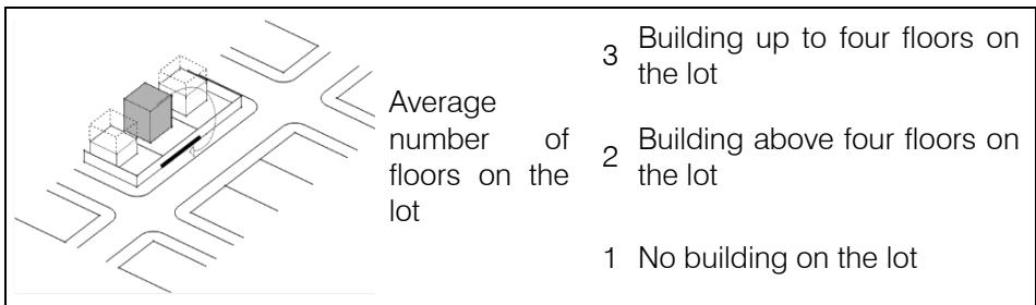 Source: Based on foundations of urban morphology and vitality
Usage projection (Table 9) aimed to evaluate how much the individual property uses the public area to complement its activities (Bentley et al., 2005[1985]). The results highlight a low relationship between not private and particular spaces in terms of interdependence of utilizations for all points studied. This condition can be explained by the absence of more consolidated commercial segments on the streets under analysis, which are dominated by housing or industry and promote limited interaction between the spatial types in question.
Table 9: Description and Scoring Classes of Morphological Components of Microscale Private Areas: Usage Projection
<table><tr><td>Use of the lot setback or public space by private authorization</td><td>Use of setback or public 3 space as a complementary area in a regulated place Use of setback or public 2 space as a complementary area, but without site regulation Lack of complementary 1 relations of use between the private area and the public space</td></tr></table>
Source: Based on foundations of urban morphology and vitality
Except for Point A, where one lot is rated at 3 (2.4% of the total), none of the others achieves such value in any unit of analysis, and the lowest rating prevails. Vogel and Mello (2017[1985]) point out the importance of as many doors as possible open to the street, which reinforces the perception of the not private space as an extension of housing, for example.
Lot accessibility (Table 10) was measured according to ease of access to the individual property by anyone from the not private space, related not just to its use, but also to the owner's control (Holanda, 2018[2002]). The results for this variable are similar to those for the previous one, because they are similar conceptually.
Table 10: Description and Scoring Classes of Morphological Components of Microscale Private Areas: Lot Accessibility
<table><tr><td>Ease of access from the private space of the building or lot to the public space because of the type of use offered by the private party</td><td>3 Publicly accessible and uncontrolled building or lot
2 Publicly accessible building or lot with control
1 Building or lot with private and controlled access</td></tr></table>
Source: Based on foundations of urban morphology and vitality
Thus, lower values apply at all points studied, with no unit of analysis reaching maximum score. Lots with intermediate values are generally private locations with public access without entrance control. The interface between building and street, enriched by the broadest range of private activities connecting with of community areas (Bentley et al., 2005[1985]), cannot be seen as contributing to the promotion of urban vitality at any of the points analyzed.
As a measurement of the ability to see and be seen from the private environment in the public space, setback visual permeability (Table 11) focused explicitly on the enclosures of building alignments and other built area in this local (Koury, 2015). The evaluation units alternate between extensive grassed front of the lot, surrounded by perimeter protective artifacts common to the pattern of industrial occupation and condominiums, and single-family residential lots with minimal or nonexistent setbacks and high walls or fences. This situation produces a wide range of ratings in which it is relatively frequent for the only possibility of eye contact to be the building openings, which negatively affects the social dynamics of the street in front (Koury, 2015). Still, this condition needs to be analyzed together with the next item.
Table 11: Description and Scoring Classes of Morphological Components of Microscale Private Areas: Setback Visual Permeability
<table><tr><td>Transparency and visual permeability of both setback and lot closures</td><td>Total visual permeability in 3 building alignment and other setbacks
No visual permeability in 1 building alignment and other setbacks</td></tr></table>
Visual building permeability (Table 12) measured the ability to see and be seen between public and private places, specifically the relationship among the street and the interior of the built area in the unit of analysis (Koury, 2015). Alongside assessing the dimensions of openings, it was also evaluated whether they promote the views from indoors to outdoors and vice versa.
Table 12: Description and Scoring Classes of Morphological Components of Microscale Private Areas: Visual Building Permeability <blockquote><p>Ratio between transparent and blind areas of the building on the lot, measured on the ground floor</p><p>3</p><p>Existence of visual transparency between the building and the public space in front of the lot</p><p>2</p><p>Existence of visual transparency between the building and the public space in front of the lot, but partially obstructed by some element</p><p>1</p><p>No transparency between the building and the public spaces in front of the lot</p></blockquote>
<table><tr><td rowspan="3">Ratio between transparent and blind areas of the building on the lot, measured on the ground floor</td><td>3</td><td>Existence of visual transparency between the building and the public space in front of the lot</td></tr><tr><td>2</td><td>Existence of visual transparency between the building and the public space in front of the lot, but partially obstructed by some element</td></tr><tr><td>1</td><td>No transparency between the building and the public spaces in front of the lot</td></tr></table>
This specific variable does not achieve the same positive results as the previous one, however because even in cases where there are doors and windows these are obstructed by curtains or other blocking elements that prevent views of the inside. Moreover, while the industrial pattern is more transparent in terms of setback, its buildings tend to be more sealed off from the open space. This circumstance determines the predominance of minimum ratings at Point A and intermediate ratings at the others locals.
When studying visual building permeability, Holanda (2018[2002]) mentions the importance of replacing blind areas with places of eye interaction, identifying the correlation between more intensive use of public spaces and more openings. The configuration of the constructed landscape at the four points in question means that A and B, primarily single-family residential, have very few openings. C and D are dominated by housing buildings with facades of large windows, producing slightly better results. In many cases, these are blocked by curtains or other features that prevent a clear visual connection.
Population density (Table 13) employed data provided and aggregated by sector from the country's last available population census (IBGE, 2022). This information was taken from the ratio of inhabitants per hectare in each division. The geometric distribution of the intervals found generated three rating levels.
Table 13: Description and Scoring Classes of Morphological Components of Microscale Private Areas: Population Density
<table><tr><td>Number of
inhabitants in
the census
sector
corresponding
to the lot,
based on
official
information on
population
reception</td><td>Lot with housing density in
the upper third of the range
3 for the study area,
considering the amount
inhabitants per hectare
Lot with housing density in
the middle third of the range
2 for the study area,
considering the number of
inhabitants per hectare
Lot with housing density in
the lower third of the range
1 for the study area,
considering the number of
inhabitants per hectare</td></tr></table>
The occupation pattern for the contexts of the points under analysis appears to influence their results for this item, since A and B, which are similar in terms of uses and densities of private landscape configuration, have different scores. Ratings for the former are divided between middle and upper levels, while the latter falls exclusively into the lower class. This condition is repeated in C and D, in which no analysis unit is rated higher than minimum, with negative effects on urban vitality since a more significant population grouping increases the number of potential users of public spaces (Sim, 2019).
As smaller lot size (Table 14) tends to generate higher occupancy densities and variation of use, the defined levels are based on the most common measurements in the units of evaluation. Procedures for adapting the available land division were fundamental in developing this metric. This specific variable reflects type of land use for each point, since those with a single-family residential pattern, occupying smaller lots, tend to produce higher ratings than those of condominium or industrial utilization, related to larger sites. A and B therefore contain many units rated at maximum level, while C and D rate more at intermediate levels. The multiplicity of land use tends to result from the variety of land sizes, since the more options there are, the more urban functions are adapted to those conditions (Saboya, 2016).
Table 14: Description and Scoring Classes of Morphological Components of Microscale Private Areas: Lot Size
<table><tr><td>3</td><td>Lot frontage less than or equal to 10 m (standard defined from dimensions found in the study area)</td></tr><tr><td>2</td><td>Lot frontage between 10 and 20 m (standard defined from dimensions found in the study area)</td></tr><tr><td>1</td><td>Lot frontage greater than 20 m (standard defined from dimensions found in the study area)</td></tr></table>
In short, the set of specific variables related to private areas graphically highlights the positive variation of A and negative alteration of D through the color scale (see Figure 9 in this section). A distinct pattern of homogeneous behavior can also be seen among the group of lots evaluated for public and private contexts. When there is variation, this co-occurs throughout the set. Although this result was expected for large condominiums due to their several buildings, it is interesting to note that the affinity between these evaluation units continues for public spaces. However, the temporary characteristics presented below are also relevant to the theme.
### c) Temporary conditions
In addition to the two instances presented above, these conditions relate to elements denoting the maintenance quality of the sections under analysis. The results of the seven specific variables selected (Figure 10) are based on the understanding that the level of landscape attractiveness is also dependent on these criteria and that they are directly related to "feeling safe," adding a qualitative complement to the research since public spaces and private areas alike reveal a more quantitative bias.
 Source: Based on field surveys and Google Earth (2023) Figure 10: Classification maps of Specific Variables at the Analysis Points of Temporary Conditions on the Microscale
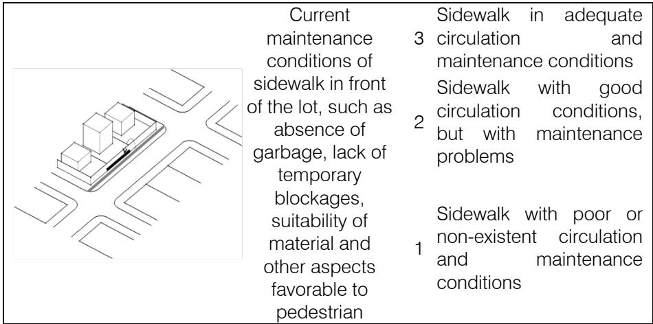
Sidewalk quality (Table 15) interprets the ease of pedestrian movement in front of the analysis unit, identifying surface-material maintenance problems or temporary obstacles to circulation, such as garbage or advertising. Points C and D generally rate much better than the others on this issue, with no ratings at lower levels and predominantly top scores.
Table 15: Description and Scoring Classes of Morphological Components of Microscale Temporary Conditions: Sidewalk Quality
 Source: Based on foundations of urban morphology and vitality
Values are more varied for A and B because street conditions range from a lack of paths to adequate provision for pedestrian circulation. A sidewalk that is absent or with serious maintenance problems detracts from urban vitality since it generates conflict between pedestrians and vehicles, impacting old people or those with reduced mobility (Gehl, 2010; Müller et al., 2023).
Setback and facade maintenance (Table 16) were analyzed regarding the conservation of the built element and the space in front of the lots. The quality of landscape treatment of the area was identified according to conditions of care for walls, openings and boundaries, together with paving and plant components in the front, to determine whether physical-spatial deterioration, which detracts from urban vitality (Vargas & Castilho, 2015[2006]), is a characteristic of the study area.
Table 16: Description and Scoring Classes of Morphological Components of Microscale Temporary Conditions: Setback and Facade Maintenance
<table><tr><td>Issues related to the proper maintenance of building facade and lot setback, such as good quality and conservation of painting, lack of graffiti and broken glass, appropriate landscape treatment of the setback (including vegetation) and others</td><td>Lot with adequate maintenance of setback and external facades in good condition</td></tr><tr><td></td><td>Lot with specific maintenance problems to its setback or external facades</td></tr><tr><td></td><td>Lot with serious maintenance problems to setback and external facades</td></tr></table>
This specific variable reveals the impact of occupation type on these issues since higher ratings apply to industrial-type units or those linked to residential condominiums. The single-family residential type presents lower overall ratings, with several lots rated between minimum and intermediate levels. Points A and B, therefore, demonstrate significant variation, while C and D predominantly return the highest ratings.
Integrity of urban furniture (Table 17) focused on aspects related to the conservation of these specific components along the street, such as dumpsters and bus stops, the only furniture types in the area. The predominance of low grades at all points for this topic is connected more to the absence of these elements than to their maintenance conditions.
Table 17: Description and Scoring Classes of Morphological Components of Microscale Temporary Conditions: Integrity of Urban Furniture
<table><tr><td>3</td><td>Furniture present and in proper conditions</td></tr><tr><td>2</td><td>Furniture present but with problems</td></tr><tr><td>1</td><td>Damaged or missing furniture in the space in front of the lot</td></tr></table>
Those that are available are generally in good condition, but they are sparsely spread throughout the area, primarily concentrated at public-transport points. Whyte (2021[1980]) points to the importance of places
for sitting and resting to promote in the promotion of vitality since they allow individuals to stay longer. This potential is not exploited at the points under analysis.
Wall and enclosure conservation (Table 18) considered maintenance of the physical barriers of the lot frontage and identified the quality of materials and treatment of these elements. Like the results for setbacks and fencing, points C and D stand out positively, with significant numbers of maximum ratings.
Table 18: Description and Scoring Classes of Morphological Components of Microscale Temporary Conditions: Wall and Enclosure Conservation
<table><tr><td></td><td>Maintenance
situation, painting
and general
conditions of the
walls and other
enclosures of the
lot, without worn
paint and without
the presence of
graffiti and
damage</td><td>3 Lot with proper
maintenance of walls
and other enclosures
Lot with specific
problems regarding the
maintenance of walls
and other enclosures
Lot with serious
problems maintaining
walls and other
enclosures</td></tr></table>
A and B's ratings are more varied, mainly at minimum level for the former and highest for the latter. Meneguetti and Beloto (2016) assert that the profusion of these barriers presents the observer with a sterile experience, which is further reinforced when poorly maintained. Points A and B can be observed as exacerbating this problem in specific locations. The usage types at C and D, organized in the form of condominiums, reflect more outstanding collective care for wall surfaces.
Vegetation conservation (Table 19) evaluated the state of maintenance and suitability of species, regarding pruning and the general condition of specimens in the analysis area. For example, problems such as negative interfaces between the plant and the circulation components tend to lower the ratings for this item.
Table 19: Description and Scoring Classes of Morphological Components of Microscale Temporary Conditions: Vegetation Conservation
<table><tr><td>State of
plant species properly
3 planted and in good
maintenance condition
Plant species with
2 specific problems of
suitability at the place of
planting or maintenance
Plant species with
serious problems of
suitability to the place of
planting and lack of
maintenance or non-
existent</td></tr></table>
The worst figures for this specific variable are at Point A, with the lowest ratings. B balances intermediate and higher values, while most ratings for C and D are higher levels. This specific variable and the three presented above are fundamental to vitality potential since defects tend to influence local inhabitants to seek out other locations with better landscape quality (Bachir et al., 2021; Hu et al., 2023).
Vehicle flow and speed (Table 20) compromise the quality of people's movement, permanence, and crossing of the public space, so this topic evaluated intensity of car movement along the different sectors of the street comparatively. Similarly, proximity to safe intersection sites such as pedestrian crossings and traffic lights was also considered. Point B's landscape type, of single-family residences with local access to the lots, brought all evaluation units maximum rating, while A, C and D are concentrated at lower level, with streets
that are more important for the neighborhood traffic. Pedestrian feelings of insecurity are caused by conflict with vehicle flow, which makes it more difficult to occupy the public space (Ganichev & Batishcheva, 2020).
Table 20: Description and Scoring Classes of Morphological Components of Microscale Temporary Conditions: Vehicle Flow and Speed
<table><tr><td>3</td><td>Traffic and vehicle speed suitable for safe pedestrian crossing</td></tr><tr><td>2</td><td>Vehicle traffic of varying intensity, with periods suitable for pedestrian crossing</td></tr><tr><td>1</td><td>Constant vehicle traffic hindering safe pedestrian crossing on the block of the lot</td></tr></table>
Since this research focuses on users' perception of the landscape, attractiveness of facade and enclosures (Table 21) should also be mentioned. Temporary changes to these elements may promote some visual stimulus for people passing in front of the unit of analysis, as a positive value for urban vitality. The results of this variable indicate that generally not many owners care about the quality of building facades. Few evaluation units at each point achieve maximum scores.
Table 21: Description and Scoring Classes of Morphological Components of Microscale Temporary Conditions: Attractiveness of Facade and Enclosures
<table><tr><td>Temporary changes to the facade and lot enclosures promoting visual stimulus and human scale for pedestrians, such as store windows or green</td><td>3 Facade fully compatible with pedestrian scale and attractive because of its treatment
Existence of any element of attraction on the facade, such as architectural treatment close to the pedestrian scale
Absence of attractive facades and enclosures on pedestrian scale</td></tr></table>
Residential condominiums and industrial uses tend to generate monotonous landscapes, mainly because the buildings follow their typology. Even in cases of single-family homes, buildings that differ from a particular pattern type are rare. This circumstance leads to a prevalence of lower values at all four analysis points. Facades serve as an element of interval and connection between interior and exterior. They can eliminate the rigid division between internal and external areas (Hertzberger, 2016[1991]) while providing scenic dynamism and interest for pedestrians.
In summary, the set of specific variables relating to temporary conditions (see Figure 10 in this section) classifies several lots in the upper range of vitality potential at points B, C, and D. The latter two also have none classified as low, and the first has only five rated at that level. About three quarters of A's units are rated as low or medium low quality in terms of relationships with urban-vitality potential. C and D's high results can be evaluated from the occupation type in these areas.
If, on the one hand, the usage pattern of condominiums tends to discourage interactions between public and private spaces by stimulating an individualized and segregated lifestyle (Low, 2004), on the other hand, they also foster a more excellent emphasis on maintaining the aesthetic appeal of properties, considering the significance of living as a symbol of social status (Vainer, 2013). Completion of the evaluation demands consideration of the study area at night.
### d) Nighttime Scenarios
Given that the crime mapped at the four analysis points occurred predominantly at night, particular issues of the landscape need to be evaluated during this period. The six variables related to this theme (Figure 11) are presented individually below.
 Source: Based on field surveys and Google Earth (2023) Figure 11: Classification Maps of Specific Variables at the Analysis Points of Nighttime Scenarios on the Microscale
The general lighting of public spaces (Table 22) is fundamental to feelings of security, and consequently to vitality. It was measured based on to amount and type of light in the study areas. Considering that places lit with cooler colors allow greater spatial perception for the better reproduction of their colors, shapes, and textures, lighting conditions tending more towards white were considered more positive for vitalized areas (Zhang et al., 2022).
Table 22: Description and Scoring Classes of Morphological Components of Microscale Nighttime Scenarios: General Lighting of Public Spaces
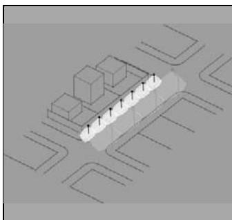
 Public lighting conditions in front of the lot or in its vicinity, with the presence of a high light fitting, focused on lighting the street as a whole
- Presence of lamppost of
- 3 perfect operating conditions in front of the lot
- Presence of lamppost of perfect operating conditions
- 2 perfect operating conditions in the immediate surroundings of the lot
No lamppost in front of the 1 lot or in its immediate surroundings
The results of this specific variable indicate a significant disparity between the public lighting conditions of the analysis points. At the same time, $100\%$ of B's units are rated at minimum due to poorly lit roads, with simple lampposts on one side of the street only and with yellowish light, all lots at point D, with lampposts on both sides of the road and white light, rated maximum. Intermediate conditions are found throughout C and in most of A, where although white light promotes better perception of public spaces, its placement on just one side of the street cannot compare with the provision at D.
General lighting of private areas (Table 23) evaluated the extent to which this contributes light to nighttime perception of the public space. This contribution occurs at isolated points at A and B. Only two lots at A and three at B have some type of system that positively affects the facing sidewalk.
Lighting condition of the private area affecting nighttime perception in the public space in front of the lot or in its vicinity
<table><tr><td>Lighting condition of the private area affecting nighttime perception in the public space in front of the lot or in its vicinity</td><td>Presence of directed or diffused light towards the public space from the private area immediately in front of the lot
Presence of directed or diffuse light towards the public space from the private area in the immediate vicinity of the lot
No contribution of private lighting to public space</td></tr></table>
In the other sections, this proportion is significantly higher, possibly because the residential condominium structure has more resources for improving the conditions of light distribution to the surroundings. The highest ratings are observed for three evaluation units in C, whereas in D, this value applies to six units. Regarding public safety, data from the Institute of Transport and Development Policy (ITDP, 2020) indicates that up to $20\%$ lower crime figures are achieved just through more outstanding care for lighting.
Nighttime public use (Table 24) relates to specific activities at night in places of shared use. Such activities stimulate concentrations of people in these areas and are therefore positive for the promotion of vitality (Zhang et al., 2023). In many cases, these are uses related to the food trade, found at some points in the study areas.
Table 24: Description and Scoring Classes of Morphological Components of Microscale Nighttime Scenarios: Nighttime Public Use
<table><tr><td>Temporary
occupations
of the public
space at
night in front
of the lot or in
its vicinity</td><td>Presence of uses with
temporary occupation of
public space in front of the
lot
Presence of uses with
temporary occupation in the
immediate surroundings of
the lot
No temporary use and
occupation near the lot</td></tr></table>
Only one lot at Point D receives maximum rating in this regard, despite expectations that these activities would also be found at the others since their streets are considered more important in the local road network and therefore more likely to receive such uses. However, no other analysis units rated higher than minimum. The
vitality and occupation of the spaces are reinforced by temporary uses, commercial or otherwise, of the public area (Whyte, 2021[1980]). However, this aspect is not significant at the four sites analyzed.
Nighttime symbolic spaces (Table 25) are those that acquire some specific relevance at night, either through lighting conditions or uses more related to that time of day. This condition is found in only two situations at the points under analysis, one at B and the other at C. All other evaluation units are rated minimum for this specific variable. Landmarks and landscape references at this time of day assist users' perception in their identification with space, like their functions during the day (Lynch, 2011[1960]),
Table 25: Description and Scoring Classes of Morphological Components of Microscale Nighttime Scenarios: Nighttime Symbolic Spaces
 Source: Based on foundations of urban morphology and vitality 1 No reference element near the lot
The specific variable of sidewalk lighting (Table 26) aimed to evaluate situations in which urban element is directed more specifically towards the flow of pedestrians or occupied areas, in contrast to the general brightness of public spaces, which is usually more focused on the roadway. Points A, B, and C have no type of infrastructure customized for users, who must rely for spatial perception on that provided for traffic, which justifies their minimum score.
Table 26: Description and Scoring Classes of Morphological Components of Microscale Nighttime Scenarios: Sidewalk Lighting
 Source: Based on foundations of urban morphology and vitality On the other hand, D has particular characteristics of lighting aimed at places where people gather, with specific solutions along the line of buildings that can be understood as light intended for pedestrians since they predominate in this location. But despite the wide street, the sidewalk is confined to one side, while the other is used for parking spaces, lawns, and access to lots. As discussed before, the importance of this variable is a matter not just of vitality but also of public security (Trop et al., 2023).
Evaluation of surveillance systems (Table 27) considered structures or remote monitoring equipment, which indicate the presence of possible local control and also discourage potential offenders, fostering a sense of protection for users. All points have some such infrastructure for at least one unit of analysis, as at A and B.
Table 27: Description and Scoring Classes of Morphological Components of Microscale Nighttime Scenarios: Surveillance Systems <table> <tr> <td rowspan="3">Presence of surveillance systems aimed at the public space in front of the lot or nearby</td> <td>Presence of surveillance system aimed at the public space in front of the lot</td> <td>3 system aimed at the public space in front of the lot</td> </tr> <tr> <td>Presence of surveillance system in the immediate vicinity of the lot</td> <td></td> </tr> <tr> <td>No surveillance system in the vicinity of the lot</td> <td></td> </tr> </table>
<table> <tr> <td rowspan="3">Presence of surveillance systems aimed at the public space in front of the lot or nearby</td> <td>Presence of surveillance system aimed at the public space in front of the lot</td> <td>3 system aimed at the public space in front of the lot</td> </tr> <tr> <td>Presence of surveillance system in the immediate vicinity of the lot</td> <td></td> </tr> <tr> <td>No surveillance system in the vicinity of the lot</td> <td></td> </tr> </table>
Source: Based on foundations of urban morphology and vitality
The proportion is higher for C and D (28.6% and 46.2%, respectively). Although surveillance is essential for feelings of security in public areas (ITDP, 2020; Zhu et al., 2023), its role should be questioned at the sites under analysis since it is mainly present in the gated communities of points C and D, whose owners are more concerned with ensuring protection of their perimeter than with promoting the security of the external space.
To summarize the specific variables related to nighttime scenarios (see Figure 11 in this section), this theme produced noticeably lower results than the others. Point D stands out positively for lighting and surveillance aspects and A, and B fit into the medium low level. The combined analysis of these results is discussed in the next section.
## V. INTEGRATED DISCUSSION
A weighted average based on the ratings obtained was chosen for comparative discussion of the points according to the following formula:
$$
\begin{array}{l} \text {A v e r a g e P o i n t (n)} \\= \frac {(\sum \quad G r a d e 1 x 1) + (\sum \quad G r a d e 2 x 2) + (\sum \quad G r a d e 3 x 3)}{\text {N u m b e r o f p o i n t s (n)}} \end{array}
$$
This formula was applied directly to the attribute table developed in the qGIS application using a calculation tool based on the fields of the prepared matrix. The weighted average of each point was calculated by multiplying the number of grades assigned to each lot by its value and then dividing the result by the number of evaluation units for the respective point. The resulting data is exposed in Figure 12.
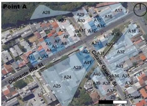
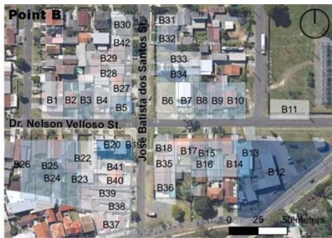
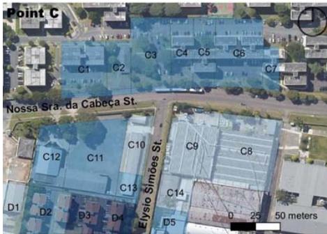
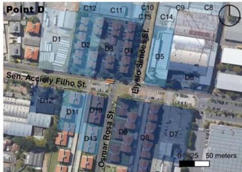
 Figure 12: Classification Maps of Weighted Averages of Analysis Points According to Themes on the Microscale
Source: Based on the previous results of the specific variables of analysis of public spaces, private areas, temporary conditions, and nighttime scenarios As a product of this calculation for public spaces (see Figure 8 in Section 4.1), averages for points A, B, and C are similar (12.4, 12.0, and 12.6, respectively) and D stands out with a higher value (14.1). It is unfeasible to identify a clear behavior pattern that relates crime type to the potential for vitality concerning the elements of these sites. Although Putra et al. (2023) assert the relevant interaction between offenses and common-use locations, this result of the present research indicates the need for an analysis of other variables for a better understanding of the relationships among urban form and criminal occurrence in public spaces in CIC.
For private areas (see Figure 9 in Section 4.2), only Point A can be seen to show a significant increase in weighted average (from 12.4 to 14.3), while B and C exhibit slight variation (from 12.0 to 11.4 and from 12.6 to 12.8, respectively). D, in turn, reveals substantial retraction (from 14.1 to 11.8). These findings indicate that certain morphological characteristics, especially those elements that reduce the potential for vitality, might be linked to crime patterns.
A possible interrelationship emerges between the vitality potential promoted by these elements and the incidence of theft, considering that the lowest scores are concentrated in places with records of this kind of crime. According to Puttini and Monteiro (2017), higher proportions of walls establish worse relations among the private and the public, contributing to increases in this criminal type due the absence of surveillance. This phenomenon is also pointed out by Branic and Kubrin (2018), whose evaluation of crime incidence near gated communities finds higher likelihood of this criminal type in such situations.
While the elements of private areas and public spaces reveal similar averages for each point, there is significant variation for characteristics of spatial maintenance and conservation. In short, the result for temporary conditions (see Figure 10 in Section 4.3) is the opposite of that for private properties, since Point A (10.9) decreases, while all others perform better in this aspect ( $B = 15.3$, $C = 17.9$, $D = 18.0$ ).
Even if Bergquist et al. (2023) confirms that physical disorder increases the risk of norm violations, relationships with criminal type are not clearly established in the study area. However C and D, associated with robbery and theft respectively, have practically the same averages, despite the unfavorable position of A.
The weighted average of results for the specific variables in the nighttime scenarios (see Figure 11 in Section 4.4) at Point A, for example, amounts to less than half of the results for private areas, demonstrating the precarious landscape at night in this location. In any case, no other section achieves a value higher than any theme studied. However, the difference in behavior between D and the others can be noted, with a relatively higher weighted average (12.5), due to lighting conditions and to the presence of nighttime activities (Trop, Tavory & Portnov, 2023; Zhu et al., 2023).
Comparison of weighted averages of the four themes demonstrates that temporary conditions and nighttime scenarios behave similarly. Both perform worst at Point A and best at D, with the others at intermediate levels. This result indicates possible relationships between spatial maintenance circumstances and landscape aspects at night, which depend on light characteristics. It is worth noting that enlightenment itself can also be considered an ephemerality given the mutability, and consequently diversity and vitality, introduced into nocturnal scenes (Zhang et al., 2022).
Direct connections between crime and the results for private areas can only be established where points of incidence of theft have lower scores than those where robbery was reported. Among the possible implications of these findings, those strongly related to urban forms resulting from the city planning process stand out. Notably, it is not possible to find relevant relationships within the behavior of the other themes and criminal types. This leads to the final reflections on the study.
## VI. CONCLUSION
Firstly, it is crucial to emphasize that the research considers the potential of the landscape to promote urban vitality, regardless of whether that the place is today animated by the constant presence of people. It is fundamental to highlight the significance of this issue in the context of urban planning and design processes.
Bearing this in mind, using the spatial syntax on the macroscale is a positive method of investigation because it can provide criteria focused on the morphology and fabric of the city on the microscale to identify the potential of vital spaces related to the flow of pedestrians through the streets. These two scalar approaches complement each other and contribute to a comprehensive understanding of the relationships between urban scenarios and criminal types.
Furthermore, selecting the four points of analysis is appropriate in principle because it allows interpretation of the interactions among components of the city. However, obtaining these crime spots through a collaborative mapping platform can raise questions about data reliability.
As mentioned before, potential limitations or biases introduced by using data from this repository were minimized through data reconciliation with recently available official information. The risk was reduced by filtering the received details and selecting only that wich was considered complete and consistent across topics.
These online collaboration sites have proven to be essential sources for similar studies in various fields of science, especially after recent technological advances in artificial intelligence. Moreover, the official data, whose access is notoriously tricky for academic research in Brazil, are also constantly questioned, either due to their collection methods or because of insufficiency of report standardization, and even a lack of records for many offenses. To overcome these challenges, the study adopted the collaborative platform and revised the data using recent institutional information.
Achieving the work objective, the development of the methodological essay satisfactorily identifies the importance of certain variables for vitality and it indicates more relevant urban issues in the relationship between landscape and crime in contemporary cities. Thus, it produces answers to the investigative question and confirms the guiding hypothesis of the study.
The analytical variables related to the potential for vitality with more significant interactions among urban forms and public security are associated with private spaces. Additionally, they show similar behavior for the parameters of temporary conditions and nighttime scenarios.
However, the need to apply the procedures in other contexts is pointed out, with adaptations to local conditions. Possible challenges of generalizing the findings and adapting the methods to different urban settings must be overcome to promote the benefits of corroborating the results of this research and its methodological and technical choices.
### ACKNOWLEDGEMENTS
To Conselho Nacional de Desenvolvimento Científico e Tecnológico (CNPq), Fundação Araucária de Apoio ao Desenvolvimento Científico e Tecnológico do Estado do Paraná (FA), and Pontificia Universidade Católica do Paraná (PUCPR) for supporting the development of the research.
Generating HTML Viewer...
References
41 Cites in Article
Miguel Nunes (1983). Validação de processos de ensaios de equipamentos eletromédicos destinados ao monitoramento, estimulação e cardioversão cardíaca segundo a série de normas técnicas ABNT NBR IEC 60601..
Nora Bachir,Lahouari Bounoua,Messaoud Aiche,Mustapha Maliki,Joseph Nigro,Laila El Ghazouani (2021). The simulation of the impact of the spatial distribution of vegetation on the urban microclimate: A case study in Mostaganem.
I Bentley,A Alcock,P Murrain,S Mcglynn,G Smith (1985). Responsive environments: a manual for designers.
Magnus Bergquist,Marvin Helferich,Maximilian Thiel,Simon Berg Hellquist,Sofiia Skipor,Winner Ubianuju,Emma Ejelöv (2023). Are broken windows spreading? Evaluating the robustness and strengths of the cross-norm effect using replications and a meta-analysis.
N Branic,C Kubrin (2018). Gated communities and crime in the United States.
Brasil (1940). Decreto-Lei Federal.
Yasmine Ezzeddine,Petra Bayerl,Helen Gibson (2023). Safety, privacy, or both: evaluating citizens’ perspectives around artificial intelligence use by police forces.
Alexander Ganichev,Oksana Batishcheva (2020). Evaluating the conflicts between vehicles and pedestrians.
Jan Gehl (2010). Cities for people.
Anna Grabiec,Agnieszka Łacka,Weronika Wiza (2022). Material, Functional, and Aesthetic Solutions for Urban Furniture in Public Spaces.
(2023). Satellite image of Curitiba.
H Hertzberger (1991). Lessons for students in architecture.
B Hillier,J Hanson (1984). The social logic of space.
Robbie Ho,Wing Au (2021). Effect of Street Performance (Busking) on the Environmental Perception of Public Space.
F Holanda (2002). O espaço da exceção.
X Hu,X Zou,H Fan (2023). Analysis of landscape influencing factors of urban waterfront greenways based on the scenic beauty estimation method, taking Tongjian Lake in Hangzhou as an example.
João Bonametti (2023). A ação do IPPUC na transformação da paisagem urbana de Curitiba a partir da área central.
David Hensher (2020). Performance contributors of bus rapid transit systems within the ITDP BRT standard.
R Koury (2015). Considerações sobre a boa cidade: justiça ambiental urbana e sustentabilidade.
C.-M Lee (2023). Criminal behavior and contingency.
Zhitao Li,Guanwei Zhao (2023). Revealing the Spatio-Temporal Heterogeneity of the Association between the Built Environment and Urban Vitality in Shenzhen.
Yue Liu,Xiangmin Guo (2023). A Dynamic Prediction Framework for Vitality of Urban Public Space - From hypothesis to algorithm and verification.
S Low (2004). Behind the gates: Life, security, and the pursuit of happiness in Fortress America.
K Lynch (1960). Translation of Jefferson Luiz Camargo.
K Meneguetti,G Beloto (2016). Entre a rua e o muro: a construção de uma interface nos condomínios horizontais fechados.
Abdelbaseer Mohamed,Claudia Van Der Laag Yamu (2023). Space Syntax has Come of Age: A Bibliometric Review from 1976 to 2023.
A Müller,A Ruiz-Padillo,V Dorneles,F Romano (2023). Sidewalk assessment from the perspective of accessibility: A systematic literature review.
Fui Ofr -Onde,Roubado (2018). Dados de crime de Curitiba.
M Paköz,D Yaratgan,A Şahin (2022). Remapping urban vitality through Jane Jacobs' criteria: The case of Kayseri, Turkey.
D Putra,W Salim,Indradjati,N Prilandita (2023). Understanding the position of urban spatial configuration on the feeling of insecurity from crime in public spaces.
A Puttini,C Monteiro (2017). Espaço urbano e criminalidade: uma análise sobre o padrão de crime no bairro de Boa Viagem.
R Saboya (2016). Fatores morfológicos da vitalidade urbana -parte 1: densidade de usos e pessoas.
D Sim (2019). Soft city: Building density for everyday life.
Tamar Trop,Sharon Shoshany Tavory,Boris Portnov (2023). Factors Affecting Pedestrians’ Perceptions of Safety, Comfort, and Pleasantness Induced by Public Space Lighting: A Systematic Literature Review.
C Vainer,M Gomes,R Mais,I Cardoso (2013). Comentários à obra.
H Vargas,A Castilho (2006). Intervenções em centros urbanos: objetivos, estratégias e resultados.
Tara Vinodrai,Shauna Brail (2023). Cities, COVID-19, and counting.
A Vogel,M Mello (1985). Quando a rua vira casa: a apropriação de espaços de uso coletivo em um centro de bairro.
W Whyte (1980). The social life of small urban spaces.
Junwei Zhang,Xintao Liu,Xiaoyue Tan,Tao Jia,Ahmad Senousi,Jianwei Huang,Ling Yin,Fan Zhang (2022). Nighttime Vitality and Its Relationship to Urban Diversity: An Exploratory Analysis in Shenzhen, China.
Meng Zhu,Rujie Teng,Canxiang Wang,Yu Wang,Jiaqi He,Fan Yu (2023). Key environmental factors affecting perceptions of security of night-time walking in neighbourhood streets: A discussion based on fear heat maps.
No ethics committee approval was required for this article type.
Data Availability
Not applicable for this article.
How to Cite This Article
Letícia Peret Antunes Hardt. 2026. \u201cUnveiling Dynamics of Contemporary Cities: The Influences of Urban form on the Potential for the Socio-Spatial Vitality of Streets\u201d. Unknown Journal GJHSS-C Volume 23 (GJHSS Volume 23 Issue C7): .
Explore published articles in an immersive Augmented Reality environment. Our platform converts research papers into interactive 3D books, allowing readers to view and interact with content using AR and VR compatible devices.
Your published article is automatically converted into a realistic 3D book. Flip through pages and read research papers in a more engaging and interactive format.
Starting from the assertion that vitality can be promoted by morphological elements, the article focuses on the significance of understanding these relationships for the urban security. The research aims to develop an original methodological essay in different scalar approaches of the Cidade Industrial de Curitiba (CIC) neighborhood in the state capital of Paraná, Brazil. The study began with spatial syntax on a macroscale (CIC) associating road axes integration with crime spots, resulting in the selection of four analysis points on the microscale (street). The integration of these two scales as a unique feature of the study. Considering the lot frontage as a unit of evaluation for interpreting characteristics of public spaces, private areas, temporary conditions, and nighttime scenarios, the answers to the investigative question indicate similar behavior for the parameters of the two latter themes. At the same time, significant connections with criminal activities are found only for the second subject.
Our website is actively being updated, and changes may occur frequently. Please clear your browser cache if needed. For feedback or error reporting, please email [email protected]
Thank you for connecting with us. We will respond to you shortly.