Introduction-Maharashtra is the second highest populated, third largest in area and the second most industrialized state in India. The state of Maharashtra came into existence on 1st May 1960. The Geographical location of the Maharashtra is bounded between latitude 16.40 to 22.10 N and longitude 72.60 to 80.90 E. As per 2011 census, the total population of Maharashtra is 112.37 Million, which is 9.29% of the India’s population (1210.19 Million). The State has the geographical area of 0.307 Million Sq. Km., which is about 9.4 per cent of the total area of India. The average rainfall of the State is approximately 1360 mm. The maximum rainfall, about 88 per cent occurs in four months between June to September, about 8 per cent between October to December and remaining 4 per cent after December. Further, rainfall is ranging from 400 mm to 6000 mm in different parts of the State. It is revealed from this, that there is significant variation in rainfall distribution and its occurrence. The State witnesses frequent drought conditions. Almost 42.5% area of the State is drought prone.
## I. INTRODUCTION
Meharashtra is the second highest populated, third largest in area and the second most industrialized state in India. The state of Maharashtra came into existence on $1^{\text{st}}$ May 1960. The Geographical location of the Maharashtra is bounded between latitude $16.4^{\circ}$ to $22.1^{\circ}$ N and longitude $72.6^{\circ}$ to $80.9^{\circ}$ E. As per 2011 census, the total population of Maharashtra is 112.37 Million, which is $9.29\%$ of the India's population (1210.19 Million). The State has the geographical area of 0.307 Million Sq. Km., which is about 9.4 per cent of the total area of India. The average rainfall of the State is approximately 1360 mm. The maximum rainfall, about 88 per cent occurs in four months between June to September, about 8 per cent between October to December and remaining 4 per cent after December. Further, rainfall is ranging from 400 mm to 6000 mm in different parts of the State. It is revealed from this, that there is significant variation in rainfall distribution and its occurrence. The State witnesses frequent drought conditions. Almost $42.5\%$ area of the State is drought prone.
Water is a prime natural resource, used for multiple uses as domestic, irrigation, industry, power generation, navigation etc. Water is fundamental resource to life, livelihood, food security and sustainable development. Water which was once considered as abundant has now become a scarce & economic resource. Water should be used in judicial and integrated manner to maximize economic and social welfare.
The distribution of water resources is uneven over a large part of the State. Such area is therefore, water deficit whereas a small part is bestowed with abundance in water. The State Water Policy formulated by the Government of Maharashtra in year 2003 envisages that, the water resources of the State shall be planned, developed & managed with a river basin and sub-basin as the unit. This policy states that, the distress in water availability during deficit period shall be shared equitably amongst different sectors of water use and also amongst upstream and downstream users.
## II. WATER RESOURCES IN MAHARASHTRA
Total water resource on earth is estimated to be about 1400 million cubic Km, which is $0.25\%$ of the planet's mass and if spread evenly over its surface, it would cover the planet to a height of $2.7\mathrm{Km}$. But more than $97\%$ is in the form of oceans and seas, $2\%$ is locked in ice-caps and glaciers and a large portion of remaining $1\%$ lies far too deep in the ground to exploit. Thus only 0.2 million cubic km is fresh water in rivers, lakes, swamps, reservoirs and 23.4 million cubic km is ground water which is mostly saline.
India is second largest populated country in the world, having $16\%$ of the world's population with just $4\%$ of water resources. The main source of water is annual precipitation including snow fall, has been estimated to be of the order of 4000 Billion Cubic Meter (BCM). More than half of that, returns to atmosphere by evaporation and seepage in to the ground. The balance water resource, which occurs as natural run off in the rivers is estimated to 1869 BCM, considering both surface and ground water.
### a) Surface Water Allocated by the Tribunal
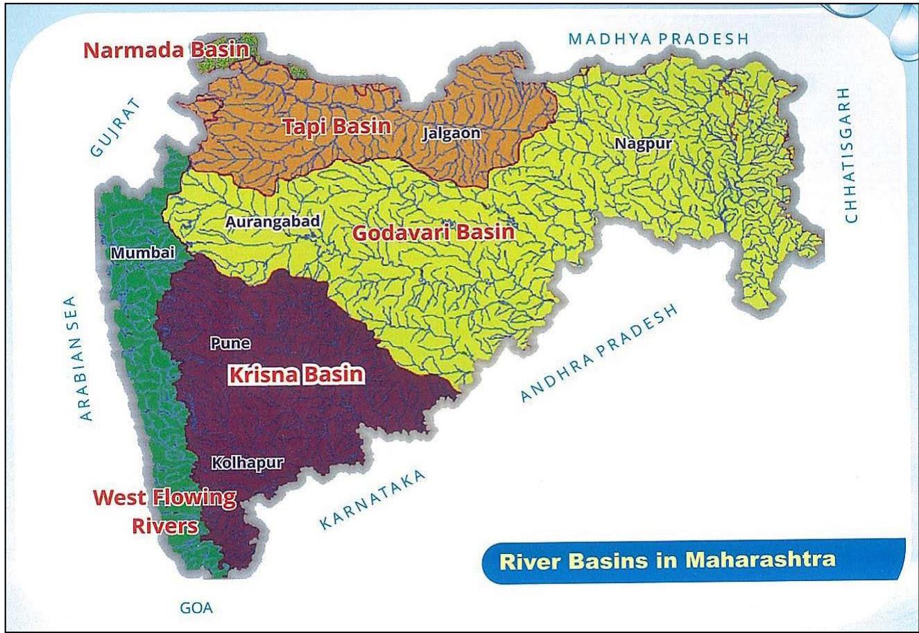
There are different Tribunal Awards, Committee reports or Agreements between the party States regarding water disputes or water sharing of interstate rivers. These awards/reports/agreements are binding on the State. The water allotted basin wise to the State by the Tribunal is shown below for six river basins in Maharashtra named Godavari, Tapi, Krishna, Narmada, Mahanadi and West Flowing rivers. The geographical areas, water availability, water available for use as per Tribunal award are given in the Table no. 1.

Table No. 1: Water Allocated to State of Maharashtra in Different Basins
<table><tr><td rowspan="2">Sr. No.</td><td rowspan="2">Basin</td><td rowspan="2">Avail. Water in Mcum</td><td rowspan="2">Allocated by</td><td colspan="4">Water Allocated in Mcum(a)/ TMC(b)
(By Tribunal/Committee/Agreement)</td></tr><tr><td colspan="2">Water Allocation Mcum (TMC)</td><td colspan="2">Total Water with Regeneration</td></tr><tr><td>(1)</td><td>(2)</td><td>(3)</td><td>(4)</td><td>5(a)</td><td>5(b)</td><td>6(a)</td><td>6(b)</td></tr><tr><td>1</td><td>Godavari</td><td>38607</td><td>GWDT</td><td>29023</td><td>1024.93</td><td>29023</td><td>1024.93</td></tr><tr><td rowspan="2">2</td><td rowspan="2">Krishna</td><td rowspan="2">29300</td><td>KWDT-I</td><td>15854</td><td>560</td><td>16562</td><td>585</td></tr><tr><td>KWDT-II</td><td>18855</td><td>666</td><td>18855</td><td>666</td></tr><tr><td>3</td><td>Tapi</td><td>7027</td><td>Iyyengar Committee 5420 and Ukai Dam-141.6</td><td>5561</td><td>196.40* (191.4+5)</td><td>5995</td><td>211.71</td></tr><tr><td>4</td><td>WFR (Konkan)</td><td>64218</td><td>WFRB Master plan</td><td>64219</td><td>2267.86</td><td>64219</td><td>2267.86</td></tr><tr><td>5</td><td>Narmada</td><td>308</td><td>NWDT</td><td>308</td><td>10.88</td><td>308</td><td>10.88</td></tr><tr><td>6</td><td>Mahanadi</td><td>102</td><td>-</td><td>102</td><td>3.60</td><td>103</td><td>3.64</td></tr><tr><td>7</td><td>Total</td><td>1,39,562</td><td>(Excluding KWDT-II)</td><td>115067</td><td>4063.67</td><td>116210</td><td>4104.02</td></tr></table>
- Source: Integrated State Water plan for Maharashtra (2018), Water Resources Department, Government of Maharashtra, Vol.-I Page No. 264 & 265
- (\*196.40 TMC Water allocation includes 5 TMC from Narmada basin at Ukai Dam as per MOU with Gujarat; Total in row no.7 is excluding KWDT II; WFR – West Flowing Rivers.)
All available water cannot be used altogether because all basins are interstate basins except west flowing rivers (WFR). There are Tribunal constraints on water use of these interstate basins. The west flowing basins lies in Konkan, where Catchment Area is very less as compared to water available & $90\%$ of water flows to Arabian Sea.
### b) Ground Water Availability in Maharashtra
Groundwater is one of the most important natural resources on the earth. It plays important role in maintenance of economy, environment and standard of living of any society in the state. In absence of immediate availability of surface-water sources, a large population depends upon groundwater. It is equally important in a river basin management. It has been the primary source of water supply for domestic, agriculture and industrial purposes.
Table No. 2: Details of Ground Water Available in Maharashtra (Figure in Col. No. 5 to 6 in Mcum)
<table><tr><td>Sr. No.</td><td>Sub basin</td><td>No. of Water sheds</td><td>Catchment area (sq.km)</td><td>Net Recharge</td><td>70% of Net GW Recharge</td><td>Categorization</td></tr><tr><td>(1)</td><td>(2)</td><td>(3)</td><td>(4)</td><td>(5)</td><td>(6)</td><td>(7)</td></tr><tr><td>1</td><td>Godavari</td><td>807</td><td>152598</td><td>17498</td><td>12248</td><td>Safe</td></tr><tr><td>2</td><td>Krishna</td><td>315</td><td>69425</td><td>7817</td><td>5479</td><td>Critical</td></tr><tr><td>3</td><td>Tapi</td><td>299</td><td>52058</td><td>4651</td><td>3256</td><td>Critical</td></tr><tr><td>4</td><td>WFR (Konkan)</td><td>91</td><td>31780</td><td>2264</td><td>1583</td><td>Safe</td></tr><tr><td>5</td><td>Narmada</td><td>8</td><td>1048</td><td>35</td><td>25</td><td>Safe</td></tr><tr><td>6</td><td>Mahanadi</td><td>4</td><td>354</td><td>27</td><td>19</td><td>Safe</td></tr><tr><td></td><td>Total</td><td>1524</td><td>307263</td><td>32292</td><td>22610</td><td>Semi critical</td></tr></table>
Groundwater Surveys & Development Agency (GSDA) and CGWB have carried out the Groundwater Assessment, in the Year 2011-12, watershed-wise recharge, and annual gross groundwater draft and groundwater availability. Details of the Ground Water Availability are given in the Table no.
2. As per this assessment, total annual groundwater recharge is 32292 Mcum. However, in view of "safe" groundwater withdrawal only $70\%$ of net groundwater should be utilized so as to avoid any undesired effect on groundwater potential.
### c) Basin wise Total Water Available and Allotted
Total water availability comprises of surface as well as ground water. Surface water availability is considered on the basis of natural water available at $75\%$ dependability and the restrictions imposed by different tribunals/committees. Regarding Ground Water, though the Tribunals have permitted $100\%$ use of ground water, State Water Board (SWB) has recommended $70\%$ of groundwater for actual use and $30\%$ to be allowed for ecological purposes. Thus basin/sub basin wise total water availability is given in the Table no.
3.
Table No. 3: Basin-wise Surface & Ground Water Available in Maharashtra
<table><tr><td>Sr.
No.</td><td>Basin</td><td>Catchment Area (Sq. km)</td><td>%</td><td>Surface Water Available (Mcum)</td><td>Surface water allotted (Mcum)</td><td>GW Avail. In Mcum</td><td>Total Water Avail. (Mcum) (6+7)</td><td>%</td></tr><tr><td>(1)</td><td>(2)</td><td>(3)</td><td>(4)</td><td>(5)</td><td>(6)</td><td>(7)</td><td>(8)</td><td>(9)</td></tr><tr><td>1</td><td>Godavari</td><td>152598</td><td>49.8</td><td>38607</td><td>29023</td><td>12248</td><td>41271</td><td>29.7</td></tr><tr><td>2</td><td>Krishna</td><td>69425</td><td>22.7</td><td>29300</td><td>16562</td><td>5479</td><td>22041</td><td>16.0</td></tr><tr><td>3</td><td>Tapi</td><td>52058</td><td>16.8</td><td>7027</td><td>5995</td><td>3256</td><td>9251</td><td>6.6</td></tr><tr><td>4</td><td>WFR</td><td>31780</td><td>10.3</td><td>64219</td><td>64219</td><td>1583</td><td>65802</td><td>47.4</td></tr><tr><td>5</td><td>Narmada</td><td>1048</td><td>0.3</td><td>308</td><td>308</td><td>25</td><td>333</td><td>0.2</td></tr><tr><td>6</td><td>Mahanadi</td><td>354</td><td>0.1</td><td>102</td><td>103</td><td>19</td><td>122</td><td>0.1</td></tr><tr><td></td><td>Total:</td><td>3,07,263</td><td>100</td><td>1,39,562</td><td>1,16,210</td><td>22,610</td><td>1,38,820</td><td>100</td></tr></table>
## III. WATER POTENTIAL IN MARATHWADA
The sub basin wise surface and ground water potential available in Marathwada is given below.
### a) Surface Water Potential in Marathwada
The yield calculated for various dependability, is the surface water available on the ground in the number of sub basins. The yield at $75\%$ dependability is generally considered for the design of the projects. But, whole quantity of surface water available cannot be used in the respective sub basins for the inter-state rivers like Godavari. And hence the tribunal has put some restrictions on the use of available surface water.
The details of Surface Water Available & Allotted by the Tribunals are given in the Table no.4.
### b) Ground Water Potential in Marathwada
The ground water is one of the most important natural resources on the earth. It is the single largest and most readily available source of irrigation and large irrigation (above $50\%$ ) is depending on the ground water. In Maharashtra, a rapid growth of population and the consequent increase in irrigated agriculture, drinking water supplies and industrial needs have focused the attention of concerned to developed new water sources. The sub basin wise ground water potential in Marathwada region is given in the Table no.
5.
Table No. 5: Sub-basins wise Ground Water Potential in Marathwada
<table><tr><td rowspan="2">Sr.
No.</td><td rowspan="2">Sub Basins</td><td rowspan="2">No. of
water
sheds</td><td rowspan="2">Geographical
area in LHa</td><td colspan="2">Net Recharge G.W. in
Mcum</td></tr><tr><td>100%</td><td>70%</td></tr><tr><td>1</td><td>2</td><td>3</td><td>4</td><td>5</td><td>6</td></tr><tr><td>1</td><td>Middle Godavari</td><td>82</td><td>17.21</td><td>2551</td><td>1768</td></tr><tr><td>2</td><td>Dudhana</td><td>38</td><td>6.04</td><td>629</td><td>440</td></tr><tr><td>3</td><td>Purna</td><td>68</td><td>10.25</td><td>1409</td><td>986</td></tr><tr><td>4</td><td>Sudha-Suvarna</td><td>03</td><td>0.80</td><td>98</td><td>69</td></tr><tr><td>5</td><td>Manjra</td><td>37</td><td>7.23</td><td>860</td><td>602</td></tr><tr><td>6</td><td>Terna</td><td>16</td><td>3.24</td><td>383</td><td>268</td></tr><tr><td>7</td><td>Lendi</td><td>12</td><td>2.01</td><td>202</td><td>141</td></tr><tr><td>8</td><td>Manar</td><td>14</td><td>2.86</td><td>305</td><td>232</td></tr><tr><td>9</td><td>Kayadhu</td><td>09</td><td>2.24</td><td>360</td><td>252</td></tr><tr><td>10.</td><td>Penganga (Ptly)</td><td>20</td><td>3.80</td><td>364</td><td>250</td></tr><tr><td>11.</td><td>Bhima (Up) (Ptly)</td><td>35</td><td>5.83</td><td>612</td><td>417</td></tr><tr><td></td><td>Total</td><td>341</td><td>61.51</td><td>7773</td><td>5425</td></tr></table>
### c) Total Sub Basin-wise Water Available in Marathwada
Total water availability comprises of surface as well as ground water. Surface water availability is considered on the basis of natural water available at $75\%$ dependability and the restrictions imposed by different tribunals/committees. Regarding Ground Water, though the Tribunals have permitted $100\%$ use of ground water, State Water Board (SWB) has recommended $70\%$ of groundwater for actual use and $30\%$ to be allowed for ecological purposes. Thus basin/sub basin wise total water availability is arrived as given in the Table no.6.
## IV. WATER RESOURCES DEVELOPMENT IN MARATHWADA
### a) Surface Water Development in Marathwada
Water resources Development planning for each sub-basin is based on the available water resources in the Sub-Basin subject to the allocation within framework of the tribunal award, present scenario and future planning so as to obtain the optimal utilization of available water resources. The details of sub-basin wise irrigation development and water use are given in the Table no.7.
Table No. 7: The details of irrigation projects and water use in Marathwada
<table><tr><td rowspan="2">Sr.
No.</td><td rowspan="2">Sub Basin</td><td colspan="2">Nos. of Projects</td><td rowspan="2">Total</td><td rowspan="2">Irrigation in
Hectare</td><td rowspan="2">Water use in
(Mcum)</td></tr><tr><td>Completed</td><td>On-going</td></tr><tr><td>1</td><td>Middle Godavari</td><td>331</td><td>46</td><td>377</td><td>224577</td><td>1292.09</td></tr><tr><td>2</td><td>Dudhana</td><td>106</td><td>16</td><td>122</td><td>92019</td><td>498.50</td></tr><tr><td>3</td><td>Purna</td><td>181</td><td>53</td><td>234</td><td>141604</td><td>1433.37</td></tr><tr><td>4</td><td>Sudha-Suvarna</td><td>17</td><td>04</td><td>021</td><td>5069</td><td>30.63</td></tr><tr><td>5</td><td>Manjra</td><td>178</td><td>10</td><td>188</td><td>101493</td><td>660.05</td></tr><tr><td>6</td><td>Terna</td><td>104</td><td>02</td><td>106</td><td>63455</td><td>312.96</td></tr><tr><td>7</td><td>Lendi</td><td>99</td><td>04</td><td>103</td><td>49040</td><td>261.04</td></tr><tr><td>8</td><td>Manar</td><td>215</td><td>15</td><td>230</td><td>82679</td><td>537.82</td></tr><tr><td>9</td><td>Kayadhu</td><td>24</td><td>07</td><td>031</td><td>37461</td><td>246.79</td></tr><tr><td>10.</td><td>Penganga (Ptly)</td><td>111</td><td>19</td><td>130</td><td>118084</td><td>810.0</td></tr><tr><td>11.</td><td>Bhima (Up) (Ptly)</td><td>160</td><td>10</td><td>170</td><td>177971</td><td>626.80</td></tr><tr><td></td><td>Total</td><td>1526</td><td>186</td><td>1712</td><td>1093452</td><td>6710.05</td></tr></table>
### b) Ground Water Development in Marathwada
The ground water assessment is carried out in the State by the Groundwater Survey and Development Agency (GSDA) in the year 2011-12. The information is compiled as watershed-wise recharge annual gross groundwater draft and ground water availability for use of various purposes like driving irrigation and industry.
The assessment of total annual ground water recharge and net annual ground water availability (70%) recharge is given below. Annual gross ground water draft from irrigation wells, domestic wells and bore wells is also given in the table. The allocation for domestic and industrial water supply needs to be kept reserved, based on projected population.
Table No. 8: Sub basin wise Ground Water Development in Marathwada
<table><tr><td>Sr. No.</td><td>Sub Basins</td><td>No. of water sheds</td><td>Net Recharge G.W. in Mcum 70%</td><td>Draft (i.e. GW in use) Mcum</td><td>Future use in Mcum (Col. 5-6)</td><td>No. of addl. Wells for Irri.</td></tr><tr><td>1</td><td>2</td><td>3</td><td>5</td><td>6</td><td>7</td><td>8</td></tr><tr><td>1</td><td>Middle Godavari</td><td>82</td><td>1768</td><td>1172</td><td>596</td><td>39765</td></tr><tr><td>2</td><td>Dudhana</td><td>38</td><td>440</td><td>391</td><td>49</td><td>3261</td></tr><tr><td>3</td><td>Purna</td><td>68</td><td>986</td><td>758</td><td>228</td><td>15201</td></tr><tr><td>4</td><td>Sudha-Suvarna</td><td>03</td><td>69</td><td>25</td><td>44</td><td>2928</td></tr><tr><td>5</td><td>Manjra</td><td>37</td><td>602</td><td>609</td><td>-7</td><td>0</td></tr><tr><td>6</td><td>Terna</td><td>16</td><td>268</td><td>322</td><td>-54</td><td>0</td></tr><tr><td>7</td><td>Lendi</td><td>12</td><td>141</td><td>87</td><td>54</td><td>3623</td></tr><tr><td>8</td><td>Manar</td><td>14</td><td>232</td><td>101</td><td>131</td><td>8683</td></tr><tr><td>9</td><td>Kayadhu</td><td>09</td><td>252</td><td>156</td><td>96</td><td>6426</td></tr><tr><td>10.</td><td>Penganga (Ptly)</td><td>20</td><td>250</td><td>125</td><td>125</td><td>8656</td></tr><tr><td>11.</td><td>Bhima (Up) (Ptly)</td><td>35</td><td>417</td><td>237</td><td>180</td><td>9520</td></tr><tr><td></td><td>Total</td><td>341</td><td>5425</td><td>3621</td><td>1442</td><td>98063</td></tr></table>
## V. WATER TRANSFER WITHIN THE STATE OF MAHARASHTRA
The most effective ways to increase the irrigation potential for increasing the food grain
The criteria for the classification of the basin or sub basin is decided as per the guide lines given in the Report of Maharashtra Water and Irrigation Commission (1999) as given below.
Below 1500 Cum per Ha of cultivable area - Highly deficit
1500 to 3000 Cum per Ha of cultivable area – Deficit
3000 to 8000 Cum per Ha of cultivable area - Normal
8000 to 12000 Cum per Ha of cultivable area - Surplus
Above 12000 Cum per Ha of cultivable area – Abundant
Maharashtra State is covered by six river basins viz. Godavari, Krishna, Tapi, West Flowing Rivers (WFR-Konkan), Narmada and Mahanadi basins. Large variation of natural surface water availability within basins and sub-basins exists in Maharashtra State in general. Average annual surface water availability varies from 0.16 Mm3/Sq.Km. in Tapi basin to 2.07 Mm3/ Sq.Km. in west flowing river basin. Projects for interstate water transfer, inter-basin water transfer within State, as well as inter-sub-basin water transfer, are in existence and are also being planned. Shortage of water resources, continuous drought situations or flood situations, demand planning of such water transfer projects in aggrieved sub-basin or water deficit subbasin in particular.
In almost all the basins, expect WFR basin in the State, planning of the available water is completed. Some basin and sub-basin are facing the problems of shortage of water due to lesser availability of natural or allotted water, as well as increase in demand both for irrigation and non-irrigation purposes. Whereas some basins e.g. WFR basin in the State have surplus water. In order to meet the demand of deficit basins, intra state production, mitigate floods and droughts and reduce regional imbalance in the availability of water is considered to be the inter-linking of the rivers to transfer water from the surplus rivers to deficit areas.
water transfer schemes similar on the line of interstate water transfer schemes are porposed. Those schemes include inter basin transfer as well as intra basin water transfer (Inter sub basin) within the State. The details of planning for Transfer of water from surplus sub-basins to deficit sub-basins in the State are given in the Table no.9.
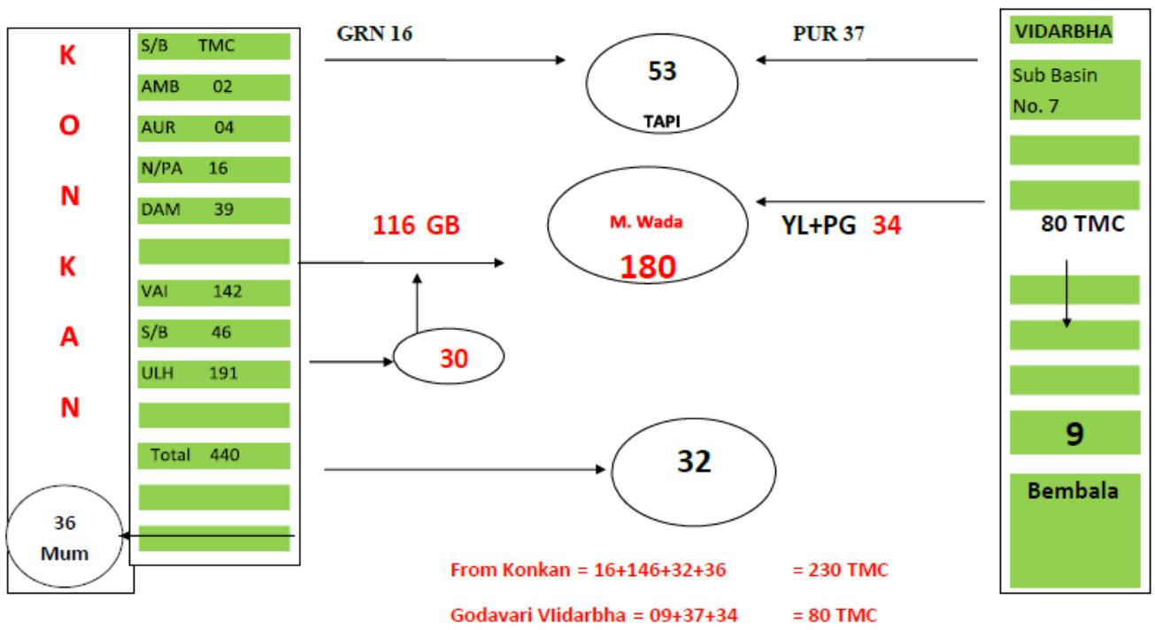 Figure:1 Model for Intra & Inter Basin Transfer of Water
From the above table, it is seen that, the Godavari basin, in Vidarbha region is having 2261 Mcum (80 TMC) of surplus water in some sub basins, after keeping water up to 8000 Cum/Ha of culturable area (Normal Basin) for the use of those sub basins themselves. The surplus water is distributed as below.
- 257 MCum (9 TMC):- is proposed to be use in Bembala deficit sub basin under Vidarbha region i.e. intra basin transfer of water.
- 953 MCum (34 TMC):- this is also proposed as intra basin transfer of water to be used in Marathwada as 553 Mcum (20 TMC) for recoupment of Penganga dam storage & 400 Mcum(14 TMC) for Yeldari dam, being replacement of water used by Vidarbha region in the upstream reaches of these dams.
- 1051 MCum (37 TMC):- This water is also proposed as intra basin transfer of water for the deficit sub basin like Satpuda, Tapi South and Purna of Tapi Basin.
- Total: 2261 MCum.(80 TMC):- Proposed use from Surplus water of Godavari Basin for Deficit sub basins as above.
From the above table, it is seen that, the Godavari basin & WFR of Konkan Basin are having surplus water for transfer to other deficit basins.
The WFR of Konkan basin is of very much water surplus or abundant basin. All 28 sub basins are having surplus water of about 54870 Mcum (1940 TMC). But out of 28 sub basins, only 7 sub basins of north konkan are considered for transfer of water to Marathwada area in Godavari Basin, Krishna Basin and Tapi Basin being the nearest or adjacent basins. The Surplus water proposed for transfer is as below.
- 1000 MCum (36 TMC):- This water will be intra basin transfer from WFR of Konkan Basin which can be use for domestic purpose in Mumbai city.
- 3297 MCum (116 TMC):- Inter basin transfer of water for Marathwada under Godavari deficit sub basins.
- 850 MCum (30 TMC):- Inter basin transfer of water for recoupment of Jaykwadi dam storage.
- 890 MCum (32 TMC):- Inter basin transfer of water for deficit area of Krishna basin.
- 463 Mcum (16 TMC):- Inter basin transfer of water for deficit Girna sub basin of Tapi basin.
- 650 Mcum (230 TMC):- Total use proposed from Surplus water of Konkan Basin for Deficit basins as shown above.
Thus the total use of 230 TMC of water will be done from WFR basin out of total available water of 440 TMC in northeast Konkan up to Ulhas sub basin.
## VI. WAY FORWARD
While studying the water resources development and management in the State the quantity of basin-wise water available is calculated by considering $75\%$ dependable yield, the sub-basin wise catchment area and the respective run-off. As the rivers are flowing Inter-States (except WFR) the water allotted by the Tribunals is considered for utilizing in the respective basins of the State. The surface water is proposed to be used for developing irrigation potential and for Non Irrigation use like domestic and industrial purposes. As per the guidelines for sectoral water use, prescribed by the Maharashtra Water Resources Regulatory Authority (MWRRA) about $25\%$ storage of dams is proposed for N.I. use and rest of storage is used for developing irrigation potential in the command area of the project.
Similarly the inter basin river linking proposals in Maharashtra State are in advance stage of planning for transfer of surplus water from the West Flowing Rivers (WFR) of Konkan Basin to Godavari Basin, Krishna Basin and Tapi Basin. The State has finalized the Integrated State Water Plan (ISWP), and the guidelines for transfer of water from surplus sub basins to deficit sub basins are also given very clearly. Accordingly the sub basin-wise planning is done for all six basins in the State.
Generating HTML Viewer...
References
3 Cites in Article
P Bansil (2004). A book on water management in India.
Hatem Hussain,Ahmed Obaidy,Ali Hommadi,Hayder Hudaib,Alaa Masoodi,Fouad Saeed,Nezar Saeedi (2007). Modifying the spillway of Adhaim Dam, reducing flood impact, and saving water.
K Kale,D Pawar,R Hasure,S Dingre,P Bhagat (1999). Production and Economics of Hybrid Tomato (Solanum lycopersicum) under Drip Fertigation.
No ethics committee approval was required for this article type.
Data Availability
Not applicable for this article.
How to Cite This Article
Dr. S.A. Nagre. 2026. \u201cWater Resources Potential and Development in Marathwada Region (Maharashtra State -India)\u201d. Global Journal of Research in Engineering - J: General Engineering GJRE-J Volume 22 (GJRE Volume 22 Issue J3).
Explore published articles in an immersive Augmented Reality environment. Our platform converts research papers into interactive 3D books, allowing readers to view and interact with content using AR and VR compatible devices.
Your published article is automatically converted into a realistic 3D book. Flip through pages and read research papers in a more engaging and interactive format.
Our website is actively being updated, and changes may occur frequently. Please clear your browser cache if needed. For feedback or error reporting, please email [email protected]
Thank you for connecting with us. We will respond to you shortly.