Geomorphological Changes by the Action of Coastal Processes and Anthropogenic Activties along the Coastal Zone between Ras Al-Jalaiah And Ras Az-Zour, Southern Kuwait
## I. INTRODUCTION
The Arabian Gulf is a tectonic basin formed upon the convergent movements of the Arabian plate from its northern edge and the Asian continent.
This tectonic movement was followed by the gentle downward subsidence of the Arabian plate from its eastern edge creating the Gulf basin, in which water from the oceans in the vicinity accumulated. The Arabian Gulf was then subjected to a regression period in the early Pleistocene recorded on its Arabian side as successive marine terraces and inland sabkhas (Lees, 1928; Holm, 1960; Al-Asfour, 1978, and Al-Hurban (1996)). A major regression period took place in the Pleistocene glaciation in which Arabian Gulf was almost dried out and continental conditions prevailed (Fairbridge, 1961). In the late Quaternary post-glacial, the Flandrian transgression took place resulting in the present sea level of the Gulf 5,000 years ago and leaving its marks as submarine platforms cut by stillstands of rising sea levels (Al-Asfour, 1982). In relation to tectonic settings, the eastern part of the Arabian shelf is occupied by Kuwait and possibly regarded as a borderline to the fore-deep zone of the changeable shelf bounding the Iranian Orogenic Belt (Youash, 1984). Kuwait is situated in a transitional zone between the settled Arabian foreland towards the southwestern side of the Arabian Gulf and the extensive composite delta of the Mesopotamian Plain north-northwesterly. Consequently, the distinguishing structures of the two units are displayed in the marine and coastal environments of Kuwait. Therefore, Kuwait State is subjected and influenced, to some extent, by the prevailing tectonism and geomorphic processes including aeolian and coastal weathering processes that took place during the late Pliocene-Pleistocene age, which is witnessed from the different geomorphological features occurring along the coastal area (Kassler, 1973; Al-Sarawi, et al., 1993; Al-Sulaimi & El-Rabaa, 1994).
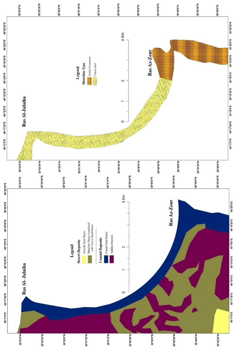
The southern coast of Kuwait is distinguished by several coastal ridges (of maximum height of 5-15 mm) composed of sediments of both oolitic (marine) and calcareous sandstone (terrestrial/aeolian) representing recent and old beaches, barriers, and coastal dunes, which are composed of oolitic sand, sandstone, and limestone (Picha, 1978, Al-Hurban, 1996). Landward, the coastal ridges separate the coastal flat with the existing extensively low-lying flat sabkhas from the open sea (Picha, 1978; Saleh, 1975; Khalaf et al., 1984a). The ridges are directed from north to south going parallel to the coastline with varying lengths reaching about $4\mathrm{km}$ near Ras Az-Zor and extending from $100\mathrm{m}$ to $300\mathrm{m}$. There are shallow depressions between these ridges filled with some small isolated sabkhas along with the formation of some nabkhas in the same area (Fig. 1).
Oolitic limestone and sands sediments are obviously represented in Az Zor area, constituting slightly to moderately consolidated oolitic limestone exposing as parallel ridges and low cliffs. Those carbonate sediments which are of the Pleistocene and Holocene age, are sourced from the northernmost marginal part of the carbonate province of the shallow Arabian shelf extending from the Strait of Hormuz in the south up to the Tigris-Euphrates delta in the north (Picha, 1978). Saleh (1975) declared the existence of several oolitic ridges in the south of Kuwait, which were deposited while the sea level was fluctuating during the Quaternary period.
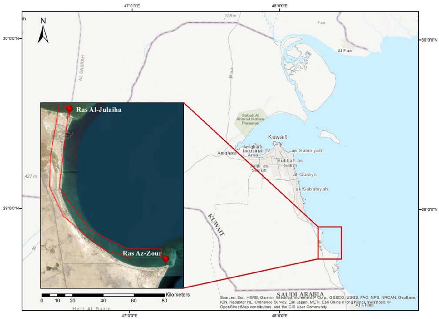 Fig. 1: Location map of the study area (Source: Esri).
Sand ridges produced by the action of tides provide a discriminative countenance of tide-prevalued continental shelves. The production of such sand ridges demands a source supplying moving sediment, either produced locally from the existing seabed or from the erosional processes occurring along the coast (Dyer and Huntley, 1999). Their pattern and physical features are resulting from a state of balance between the tidal current dynamic nature, seafloor form and structure, and supplement of sediments. On a general aspect, it is believed water depth of the sand ridges formed by tidal currents is at $< 30 - 50\mathrm{m}$, (Offf, 1963; Liu et al., 1998;
towards north-south, faults, and flexures, along with a major structural zone distinguished by frequent basement activation known as "Kuwait Arch". Those associated with the Neogene movement comprise rifting, faulting, and the tilting of beds with striking northwest-southeast and dipping northwesterly (Clarke, 1988).
The main goal of this study is to investigate the geomorphological changes along the coastal area bounded by Ras Al-Jalaiah and Ras Az-Zour in southern Kuwait and how it was developed by time passing during a 48-year period from 1973-2021 using GIS and remote sensing techniques. Before planning to use coastal sites for development activity, it is important to understand the main geomorphological processes and localization of accretion and erosion processes acting on these sites. Most of the previous studies have not comprehensively investigated the interference of the desert and coastal processes in the evolution of the geomorphology of the study area. Therefore, it is necessary to establish baseline data concerning that domain in the study area to establish a comprehensive database, for selecting areas for recreational purposes or in planning socio-economic development activities. Therefore, the program of this research was outlined for the purpose of updating investigations conducted previously on newly selected sites, particularly conducting detailed geomorphical and coastal investigations of the study area with an emphasis on the geomorphic processes and changes.
The results of this study will provide important data and information that can be used for environmental impact assessment studies. If attention was not paid to the desert and coastal processes, this might adversely impact the resources and their users. Utilization of geomorphic zones requires a comprehensive understanding of all existing procedures.
### a) Study area
The study area is a superficial, open, vulnerable bay of a maximum depth of 28m extending along the southern shore of Kuwait. Ras Al-Jalaiah promontory bounds the area northwards and Ras Az-Zour promontory bounds it southward, with a distance measured vertically of 18.085 km. It is an open sea with a high-energy environment, is characterized by a relatively steep profile with a narrow foreshore zone, and is covered by sand deposits. The dimensions of the study area are (18.085 km x 14.255 km x 20128 km x 21.702 km) with a perimeter of 56.17 km and an area of 169.327 km2. The study area is bounded between (48°16'00" E, 28°54'00" N at the northwest; 48°24'00" E, 28°54'00" N at the northeast; 48°16'00" E, 28°44'00" N at southwest; and 48°24'00" E, 28°44'00" N at the southeast).
## i. Al-Jalajah
An open coastline of sandy beaches, where the area is constituted of a hard rock surface coated by a compacted fine-medium sand layer (1m thick). The area is subjected to highly energetic currents created by the waves and tidal currents' action. In addition, this zone encompasses pocket and cuspate beaches.
## ii. Az-Zour area
Oolitic limestone beaches are found farther southward of Ras Az-Zour, where the coast is constituted of a 2 m high cliff of oolitic limestone, fronted by narrow beaches surrounded by a 700 m wide rock tidal flat, partly coated with coarse sand, from the seaside. The strong waves and currents continuously erode the cliff base, preventing sand accumulation but sometimes in little amounts.
The tidal and nearshore flats of the two southern coastal coves of Kuwait are covered with a number of sand ridges and sand spits. Their morphology, morphodynamics, and sedimentological characteristics may influence the environmental conditions and consequently the biota distribution and diversity within these tidal and nearshore flats. Therefore, understanding the genesis and dynamicity of these ridges and spits can provide valuable information for the marine environment, geology, and sedimentmorphorphy (Al-Rashidi & Al-Hurban, 2019), vulnerability to anthropogenic hazards (Al-Hurban, 2014) protection and conservation of marine natural resources and coastal zone integrated management and sustainable use.
The beach is constituted of almost 100 m wide fine-medium oolitic limestone. The tidal land is blanketed with sand spits and bars. To the land side, from the oolitic limestone zone, there exists a visible sandy tidal flat, which possesses a rocky bottom underlying thick sand deposits engraved by a group of creeps and channels (Al-Ghadban, 1980, 1990).
## II. PREVIOUS STUDIES
Studies conducted on the recent sediments of the Arabian Gulf included studying the shallow-marine sediments of Kuwait's water. Mohammed (1978), Khalaf and Ala (1980), Khalaf et al. (1984a,b), Al-Bakri et al., 1984, Al-Hurban, 2014, and Al-Rashidi & Al-Hurban, 2019) studied the geological and sedimentological properties of the recent surface sediments of the marine environment; in addition to Picha and Saleh (1977), Picha (1978), Al-Ghadban, 1980, Al-Hurban (1996), Al-Hurban and Gharib (2003 and 2004), and (Al-Hurban & Al-Ghadban, 2008) who described the sedimentomorphic characteristics of coastal sediments along the northern and southern part of Kuwait.
The climate changes and weathering processes the area witnessed affected its recent history which was obvious from the formation of the Pleistocene and
Holocene coastal ridges that of calcareous sandstone and oolitic limestone composition during the flood flow from south to north (Al-Hurban & Al-Sulaimi, 2009). The sandstone ridges show crossbedding structures pointing out the occurrence of fluvial activities while the sea level was fluctuating, as well as, the oolitic sands continued to deposit and fill in the inter-ridge area.
The submarine morphology in the open bay is characterized by the existence of ridges and banks, as they may depict ancient indurated Pleistocene or early Holocene sediments (limestone, oolitic quartzite sandstone) (Al-Ghadban, 1990). The coastal banks in the nearshore zone are roughly in a parallel alignment to the coastline, whereas the deeper banks constitute extensions of the promontories. The study area is different from other areas in the southern Arabian Gulf in the existing aeolian admixture and the shell fragments (bivalves and gastropods) which are characterized as being angular. Al-Ghadban (1990) stated that the beach is variant in its width (2-5m), which is almost flat of the indistinguishable berm with the shore heading marine word from a marine-abraded cliff of maximum height ranging from 5 and an average of 2.2m high. Most of the previous studies covered the coastal and marine recent sediments in the vicinity of the study area but for the internal domain of the study area, the existence of different marine geomorphological features was just stated not describing their sedimentomorphological characteristics. Subsequently, this study will investigate the geomorphological nature, type, and characteristics of the study area.
Al-Hurban & El-Gamily (2013) stated that sea level in the Arabian Gulf witnessed local fluctuation during the Holocene and late Pleistocene, which affected the geomorphological development and evolution of the study area. During the Würm or last glacial age (70,000 - 17,000 BP) the Gulf region was land instead of the sea (Fairbridge, 1961; Kassler, 1973) where the sea levels were lower than nowadays (100 to $120\mathrm{m}$ ) and the Arabian Gulf has a maximum depth of $100\mathrm{m}$. The Holocene sediments of the study area are of low siliciclastic constituent indicating the predominance of arid climates similar to those of the current time. The Flandrian transgression events of high sea levels involved the sedimentation of deposits composed majorly of marine shells, which normally exist in the coastal ridges foot, in the intertidal and subtidal zones.
Aladwani (2022) studied the southern coast of Kuwait in general and analyzed the shoreline changes throughout a 35-year period (1986-2021) using GIS and statistical methods. It was found that the southern shoreline witnessed alternating accretion and erosion processes due to historical changes and intervention of anthropogenic activities. A modeling vision was introduced predicting the position of the southern coast of Kuwait in 2030 and 2050.
### a) Comparison with similar areas
The study area is of a very uneven bottom structure, as the banks and ridges constitute a submerged older surface flooded by a Holocene transgression, but with less abundant and less thickness depositional. Only very thin layers of Holocene sediments cover the rocky bottom of the area (Al-Ghadban, 1990).
Comparison with other similar areas/ environments in the Arabian Gulf (e.g., Kuwait Bay, Mahammad and Shamlan, 1977, off the coast of Iran, Seibold et al., 1973; off the Qatar coast, Houbolt, 1957; off the United Arab Emirates coast, Shinn, 1973) showed the followings:
1. Existence of high carbonate content due to the influence of the little inflow of river-transported material (where Shatt Al-Arab is the closest river to the area).
2. More aeolian material are received by the Arabian Gulf sediments (Kukal and Saadallah, 1973), which considerably contributes to the origin of silt size fraction of the sediments in the studied area. Nevertheless, such a large contribution is not observed along the Qatar coast.
3. Although the proven detrital nature of the existing carbonate in the area of investigation, the grains are consistently angular differing from the observations of Houbolt's (1957) along the coast of Qatar.
Energetic tides (3m as a tidal range) and created tidal currents (1.5m/s) in the study area are common in the region of the Arabian Gulf. Such tidal currents would result in reworking the sediments as they form strong longshore and offshore currents (Figs. 2(a,b) & 3), which are different from the case in the areas that almost for tides, e.g., the Gulf of Mexico (Al Mukaimi et al. (2018a,b)) the Caribbean Sea, the Red Sea, and the Mediterranean. As a result, many variations in surficial sediment characteristics can be found among arid subtropical carbonate basins, where such characteristics can be attributed to the variability in terrestrial sediments supply, the structure of the bottom, wind activity, availability of tides, and the activity of organic nature.
## III. METHODS AND MATERIAL
For this study, the LANDSAT images (path 165, rows 40) are used to study the spatial and temporal changes in the study area and to estimate the geomorphological changes in the coastal area between Ras Al-Julaiha and Ras Az-Zour during different periods. The main source for the images for this research was Landsat from the United States Geological Survey (USGS). After acquiring the images, a pre-prepared mask was used to crop the images for the investigated area. All the processing was done using two software ArcMap and ENVI. Subsequently, the prepared images were used to quantify the changes that occurred throughout the years.
The coastline can even be extracted from a single-band image, since the reflectance of water is nearly equal to zero in reflective infrared bands, and the reflectance of the absolute majority of land covers is greater than water (Alesheikh et.al. 2007).

Fig. 2(a, b): Sedimentological and geomorphological maps of the study area: a. Sedimentological map (modified after Al-Hurban, 2014), b. Coastal geomorphological map (modified after Abou-Seida & Al-Sarawi, 1990).
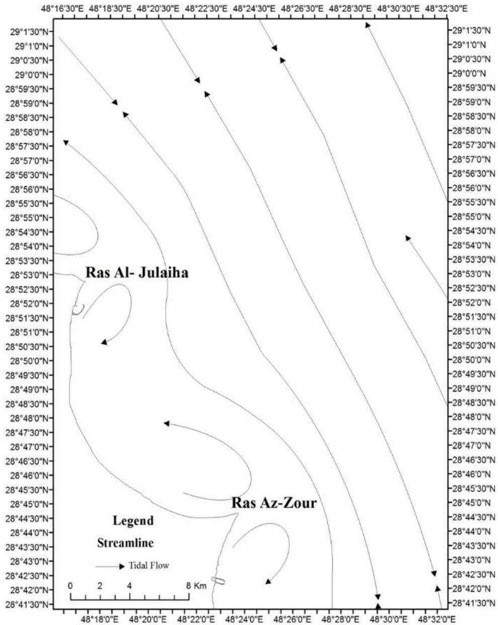 Fig. 3: Streamline of the expected tidal flow pattern off Ras Al-Julaiha and Ras Az-Zour headlands, showing the resulting residual circulation (modified after Al-Bakri etal., 1985).
The coastal area between Ras Al-Julaiha and Ras Az-Zour was extracted from the near-infrared band. Near-Infrared band exhibits a strong contrast between land and water features due to the high degree of absorption of near-infrared energy by water (Jensen, 2015).
The methodology adopted focused mainly on the following steps (Fig. 4):
1. Collection of datasets composed of LANDSAT satellite imagery.
2. Radiometric calibration by using radiometric correction that can help to make an analysis and get information from images.
3. Image classification based on unsupervised classification algorithms using the near-infrared band.
4. Change detection method.
5. Analysis and management of all exported data and study the evolution to get the result of final maps.
### a) Data sets used
LANDSAT Satellite imagery is used taken in different periods with a ground spatial resolution of $30\mathrm{m}$ and $60\mathrm{m}$. The obtained images are referenced in the World Geodetic System (WGS84) datum, in Geo Tiff format, and using the Universal Transverse Mercator system (zone UTM 39 North) as a map projection system. The main source for the images for this project was Landsat from the United States geological survey. Table 1 shows a summary of the collected Landsat satellite images for a 48-year period.
Table 1: Collected Landsat images.
<table><tr><td>Satellite Sensor Type</td><td>Year Acquired</td><td>Source</td><td>Spectral Resolution</td><td>Spatial Resolution</td></tr><tr><td>LANDSAT_1 (MSS)</td><td>1973</td><td>USGS</td><td>0.548 to 0.9 μm</td><td>60 m</td></tr><tr><td>LANDSAT_5 (MSS)</td><td>1984</td><td>USGS</td><td>0.552 to 0.923 μm</td><td>60 m</td></tr><tr><td>LANDSAT_5 (TM)</td><td>1994</td><td>USGS</td><td>0.485 to 2.223 μm</td><td>30 m</td></tr><tr><td>LANDSAT_7 (ETM)</td><td>2003</td><td>USGS</td><td>0.483 to 2.206 μm</td><td>30 m</td></tr><tr><td>LANDSAT_8 (OLI)</td><td>2013</td><td>USGS</td><td>0.443 to 2.201 μm</td><td>30 m</td></tr><tr><td>LANDSAT_8 (OLI)</td><td>2021</td><td>USGS</td><td>0.443 to 2.201 μm</td><td>30 m</td></tr></table>
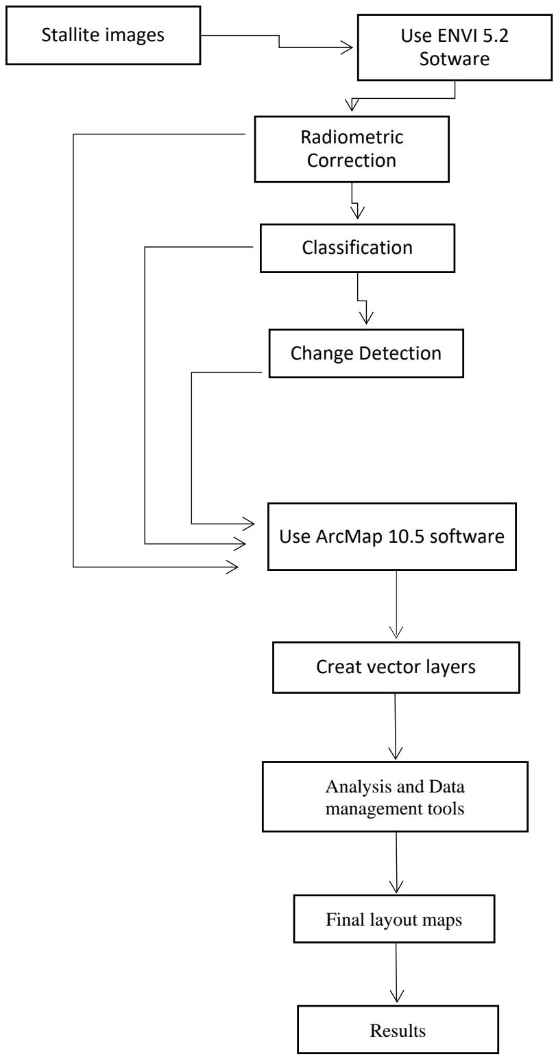
Fig. 4: The methodological framework Including data Input, processing and output.

### b) Software Used
Satellite imagery must undergo several preprocessing steps prior to being used in change detection, mapping, and analysis. The datasets, which utilized and processed using the following software:
1. ENVI image analysis software (ver.5.3, 2015) is used to import Generic Binary data, display images, and perform a radiometric correction, image conversion, and analysis.
2. ArcMap Desktop (ver. 10.5) software with the Geoprocessing extensions was used to view raster and vector data, Analysis and Data management tool, edit and geocode descriptive information, and calculate change detection and mapping.
### c) Remote sensing and GIS analysis
## i. Digital Image Processing
The following image processing was carried out from LANDSAT images to extract the needed information.
### a. Image restoration
ENVI image analysis software (ver.5.3, 2015) is used in this study to carry out digital image processing. The LANDSAT images (path 165/row 40) of 1973 and 2021 were radiometrically corrected to convert the brightness value to radiance value and the subset function of ENVI image analysis software was used to clip the study area from LANDSAT images of 1973 and 2021.
### b. Image enhancement
The LANDSAT image of the study area was enhanced by utilizing the enhancement capabilities of ENVI image analysis software. This enhancement is applied to improve the appearance of an image for human visual analysis or occasionally for subsequent machine analysis (Jensen, 2015). The enhanced images were subsequently used to investigate and update the geomorphological features of the study area.
## c. Change detection
Changes in the study area were determined by comparing the LANDSAT images in different years. The layer stack function of ENVI image software collected
Band near-infrared (NIR) from two images and produces a new, stacked image. Areas of change appear in color in the resultant image. The unsupervised classification, the identities of land cover types to be specified as classes within a scene are not generally known a priori because ground reference information is lacking or surface features within the scene are not well defined (Jensen, 2015). The produced thematic maps from the classification were exported out to separate and quantify the changed areas.
### d) Geographic information system (GIS)
All of the GIS functions and analyses in this study were completed with the ArcMap Desktop software (ver. 10.4). All exported raster layers were extracted as GIS layers. These layers hold the shoreline and coastal area.
### e) Integration of remote sensing and GIS
The integration of remote sensing data and GIS layers was used to produce a geomorphological change map of the study area. All the extracted information is saved in Geodatabase. The resultant information was analyzed and compared to achieve the project aim.
## IV. RESULTS AND DISCUSSION
In order to study the geomorphological changes along the coastal area between Ras Al-Julaiha and Ras Az-Zour during the period from 1973 to 2021, change detection maps were developed using remote sensing techniques in 5-period groups (1-5) with an interval of 9 to 11 years, in addition to a net change detection map for the 48-year period (group 6). Table 2 shows the calculated change area along with the length of the shoreline during each group period, as well as, the total area subjected to change and the variation of the length of the shoreline during the 48-year period.
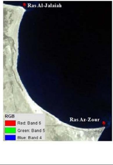
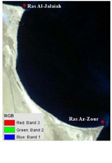
Based on the area in 1973 it was $2361600.0\mathrm{m}^2$ $(2.4\mathrm{km}^2)$ and in 1984 become $2954518.3\mathrm{m}^2$ $(3.0\mathrm{km}^2)$. In 1973, the northernmost part of the study area including Ras Al-Jalaiah and the southernmost Ras Az-Zour cuspate spit system nicely developed opposite the cape. Also, in the
Table 2: The calculated change area along with the length of the shoreline during each group period and the total calculated change.
<table><tr><td>Years Group</td><td>Change Area-m2</td><td>Length-m</td><td>Change Area-Km2</td><td>Length-Km</td><td>Per%</td></tr><tr><td>Group 1 (1973 - 1984)</td><td>3754800.0</td><td>78120.0</td><td>3.8</td><td>78.1</td><td>26</td></tr><tr><td>Group 2 (1984 - 1994)</td><td>3932442.3</td><td>87809.9</td><td>3.9</td><td>87.8</td><td>27</td></tr><tr><td>Group 3 (1994 - 2003)</td><td>2983011.9</td><td>89556.9</td><td>3.0</td><td>89.6</td><td>20</td></tr><tr><td>Group 4 (2003 - 2013)</td><td>1718182.8</td><td>82458.1</td><td>1.7</td><td>82.5</td><td>12</td></tr><tr><td>Group 5 (2013 - 2021)</td><td>2291619.5</td><td>90177.6</td><td>2.3</td><td>90.2</td><td>16</td></tr><tr><td>Total</td><td>14680056.6</td><td>428122.6</td><td>14.7</td><td>428.2</td><td>100</td></tr><tr><td></td><td></td><td></td><td></td><td></td><td></td></tr><tr><td>Years</td><td>Area-m2</td><td>Length-m</td><td>Change Area-Km2</td><td>Length-Km</td><td>Per%</td></tr><tr><td>1973</td><td>2361600.0</td><td>74520.0</td><td>2.4</td><td>74.5</td><td>19</td></tr><tr><td>1984</td><td>2954518.3</td><td>78101.9</td><td>3.0</td><td>78.1</td><td>24</td></tr><tr><td>1994</td><td>2496292.4</td><td>89112.7</td><td>2.5</td><td>89.1</td><td>20</td></tr><tr><td>2003</td><td>1326052.4</td><td>78904.9</td><td>1.3</td><td>78.9</td><td>11</td></tr><tr><td>2013</td><td>1393471.5</td><td>80837.6</td><td>1.4</td><td>80.8</td><td>11</td></tr><tr><td>2021</td><td>1806291.7</td><td>86403.2</td><td>1.8</td><td>86.4</td><td>15</td></tr><tr><td>Total</td><td>12338226.3</td><td>487880.3</td><td>12.3</td><td>487.8</td><td>100</td></tr><tr><td></td><td></td><td></td><td></td><td></td><td></td></tr><tr><td>Final Result</td><td>Change Area m2</td><td></td><td>Change Area-Km2</td><td>Length-Km</td><td>Per%</td></tr><tr><td>Group 6 (1973 - 2021)</td><td>3353611.7</td><td>98068.3</td><td>3.4</td><td>9.8</td><td>27</td></tr></table>
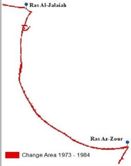
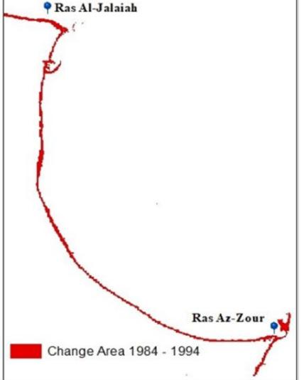
southernmost part of the study area including Ras Az-Zour cuspate spit and near the cave sand shoals were developed in 1984. The total area subject to change along the shoreline during the 11 years was calculated to be about $3.8\mathrm{km}^2$. In addition, the length of the shoreline has increased successively from $74520.0\mathrm{m}$ in 1973 (74.5km) to $78101.9\mathrm{m}$ (78.1km) in 1984 with $26\%$ of the total detected change. Figure 5 shows the change detection map through the period from 1973-1984. During the period from 1984-1994, there was a slight increment in the changed shoreline area by $0.1\mathrm{km}^2$ with a total change of $3.9\mathrm{km}^2$, as well as a $1\%$ increment of the percentage change $(27\%)$. Figure 6 shows the change detection map during this period. These two-period groups constituted the peaks for the change in the area of the shoreline in the study area indicating increasing in accretion rate on the account of erosion rate. This may be attributed to the increased of fine-grained sediments from Shatt Al-Arab in southern Iraq to the north-northeastern portion of Kuwait State due to the enormous drainage of the Mesopotamian marshes in Iraq and to a smaller degree in Iran between the 1950s and 1990s to clear large areas of the marshes in the Tigris-Euphrates river system. The marshes particularly the central marshes were drained at different times for different reasons (Fig. 7). It was described by the United Nations Environmental Program (UNEP) and other observers as one of the worst environmental disasters of the 20th century. Among the environmental effects according to the UNEP report in 2001 was the desertification of over 7,500 square miles (19,000 km2) of the marshes, which was reflected in the study area by the increase of deflated moving fine-grained sand feeding the southwesterly net longshore current' littoral drift in the study area, justifying the above-mentioned increment in the shoreline area and associated length of the shoreline.
During the third time group (1994-2003) the total area subject was $2983011.9\mathrm{m}^2$ $(3.0\mathrm{km}^2)$, as well as, the shoreline length was $89.1\mathrm{km}$ with $20\%$ of the total change through the 48-years period. Figure 8 shows the change detection map through the period from 1994-2003. During the second and third-time period groups, there were no big changes in the capes during the 19-year period just the thickness of the shoreline was eroded in the middle and in the upper of the southernmost Ras Az-Zour cuspate. The total area subject to change along the shoreline decreased from the time period group (1984-1994) from $3932442.3\mathrm{m}^2$ $(3.9\mathrm{km}^2)$ to $2983011.9\mathrm{m}^2$ $(3.0\mathrm{km}^2)$ in 1994-2003. This may be attributed to the reflooding that occurred in the marshes as the Central Marshes showed little recovery through 2003 and there was flooding in southern areas that had previously been dry since the early 1990s. This might probably caused less feeding of the deflated sand moving to the north-northeastern portions of Kuwait and consequently to the littoral drift brought by the longshore current in the study area.

(A)
(B)
(C) (A) Study area in 1973, (B) Study area in 1984, (C) Change area

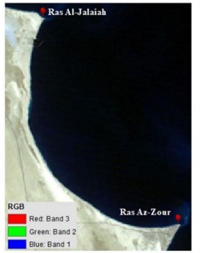
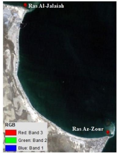
Fig. 5: Maps of the study area in the time-period group (1): (A) Study area in 1973, (B) Study area in 1984, and (C) the change detection map through the period from 1973-1984. (B)
(C)
(D) (B) Study area in 1984, (C) Study area in 1994, (D) Change area
Fig. 6: Maps of the study area in the time-period group (2): (B) Study area in 1984, (C) Study area in 1994, and (D) the change detection map through the period from 1984-1994.
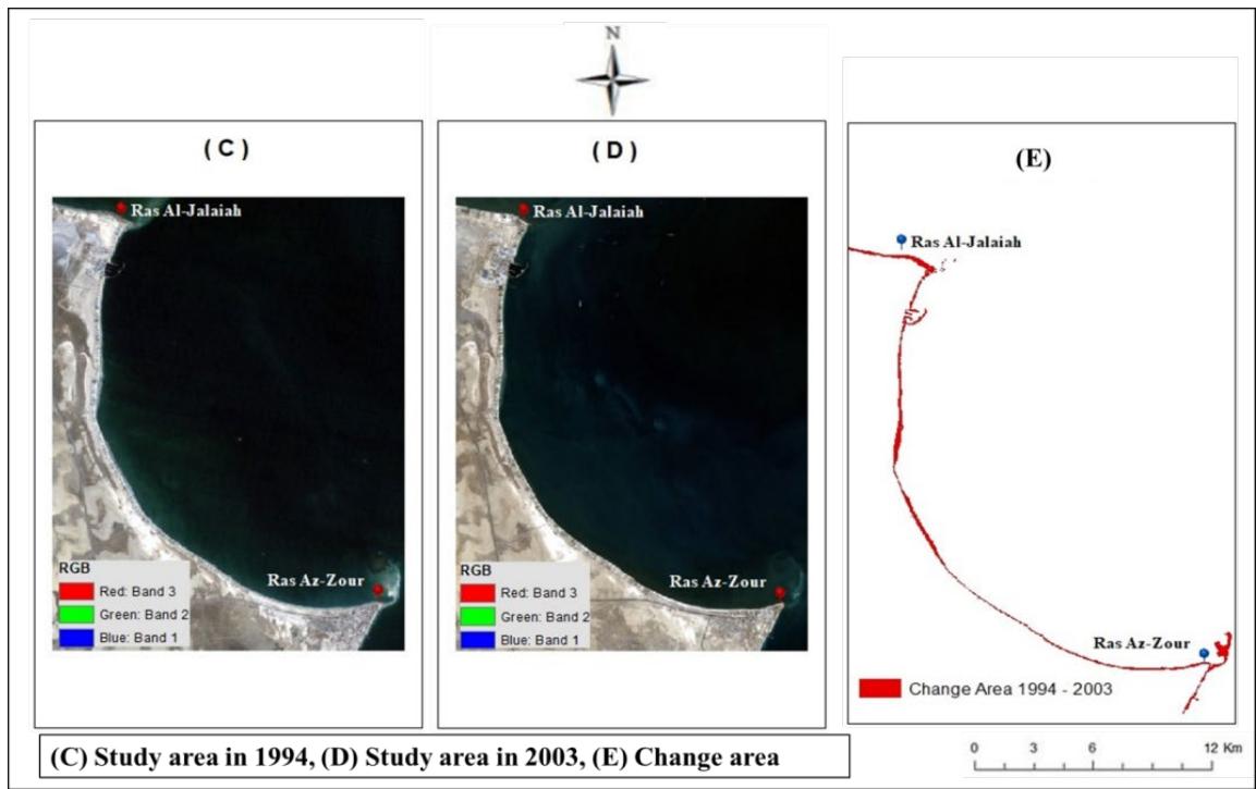
Fig. 7: A 1994 map of the Mesopotamian Marshes with the pink zones showing drained areas (http://www.mapcruzin.com/free-iraq-maps.htm direct link).
 Fig. 8: Maps of the study area in the time-period group (3): (C) Study area in 1994, (D) Study area in 2003, and (E) the change detection map through the period from 1994-2003.
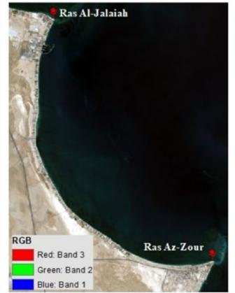
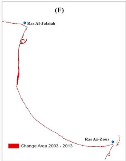
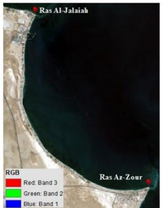
The fourth time period group (2003-2013) recorded the lowest amount of change with a total area subject to change of $1718182.8\mathrm{m}^2$ $(1.7\mathrm{km}^2)$, shoreline length of $82.5\mathrm{km}$, and $12\%$ of the total change in the 48-year period. Figure 9 shows the change detection map through the period from 2003-2013. In the fifth time-period group (2013-2021) the total area subject to change increased to $2291619.5\mathrm{m}^2$ $(2.3\mathrm{km}^2)$, the length of the shoreline increased to $90177.6\mathrm{m}$ $(90.2\mathrm{km})$, and
16% of the total change in the 48-years period, where figure 10 shows the change detection map through the period from 2013-2021. Both the fourth and fifth time-period groups constituted the fewer amounts of changes as shown in figures 9 and 10, where the total area subject to change along the shoreline during 18 years was calculated to be about $4.5\mathrm{km}^2$ and increased from $1718182.8\mathrm{m}^2$ (1.7km2) in 2003-2013 to 2291619. $5\mathrm{m}^2$ (2.3km2) in 2013-2021.

(D)
(E)
(D) Study area in 2003, (E) Study area in 2013, (F) Change area

Fig. 9: Maps of the study area in the time-period group (4): (D) Study area in 2003, (E) Study area in 2003, and (F) the change detection map through the period from 2003-2013.
(E)
(F)
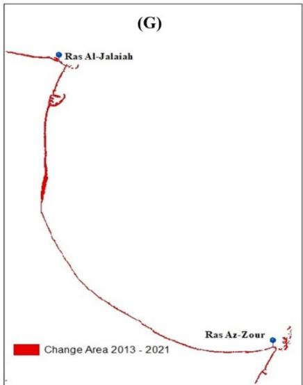
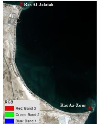
(E) Study area in 2013, (F) Study area in 2021, (G) Change area
 Fig. 10: Maps of the study area in the time-period group (5): (E) Study area in 2013, (F) Study area in 2021, and (G) the change detection map through the period from 2013-2021.
This may be attributed to the development of Al Zour oil refinery project (ZOR) in the southernmost part of Ras Az-Zour, which is regarded as one of the biggest refineries in the world (Fig. 11). Site preparation works started in 2015. Construction on the project commenced in December 2017 and was scheduled to be completed in 2020. It is operated by the Kuwait Integrated Petroleum Industries Company (KIPIC), a subsidiary of Kuwait Petroleum Corporation. It involves the development of a large number of support infrastructure buildings for administration, security, operations, and maintenance. Project activities also involved feedstock and product supply pipelines, as well as the construction of various channels, a basin for a future jetty, a barge dock, roads, and the construction of a 6.5 million barrels capacity storage tank farm and marine and export facilities (Al Zour Refinery Project (ZOR) - Hydrocarbons Technology (hydrocarbons-technology. com).
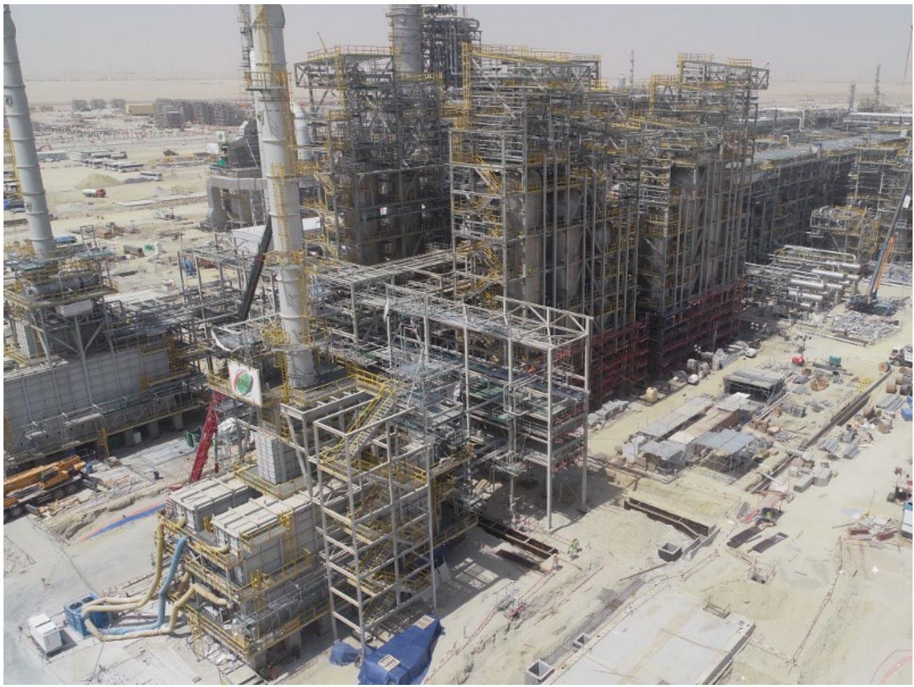 Fig. 11: Al Zour oil refinery project (ZOR) in the study area at Az Zour area southern Kuwait (Al Zour Refinery Project (ZOR) - Hydrocarbons Technology (hydrocarbons-technology.com).
Figure 12 shows the net or the total change detection map through the 48-years period from 1973-2021, where The total area subjected to change along the shoreline was calculated to be about $98068.3\mathrm{m}^2$ $(3.4\mathrm{km}^2)$ using GIS techniques. In addition, the length of the shoreline has increased successively from $74520\mathrm{m}$ $(74.5\mathrm{km})$ in 1973 to $86403.2\mathrm{m}$ $(86.4\mathrm{km})$ in 2021. In the central part of the area, deposits accumulated in the lower portion of the northernmost part of the Ras Al-Julaiha, and erosion took place in the upper portion of the southernmost Ras Az-Zour cuspate.
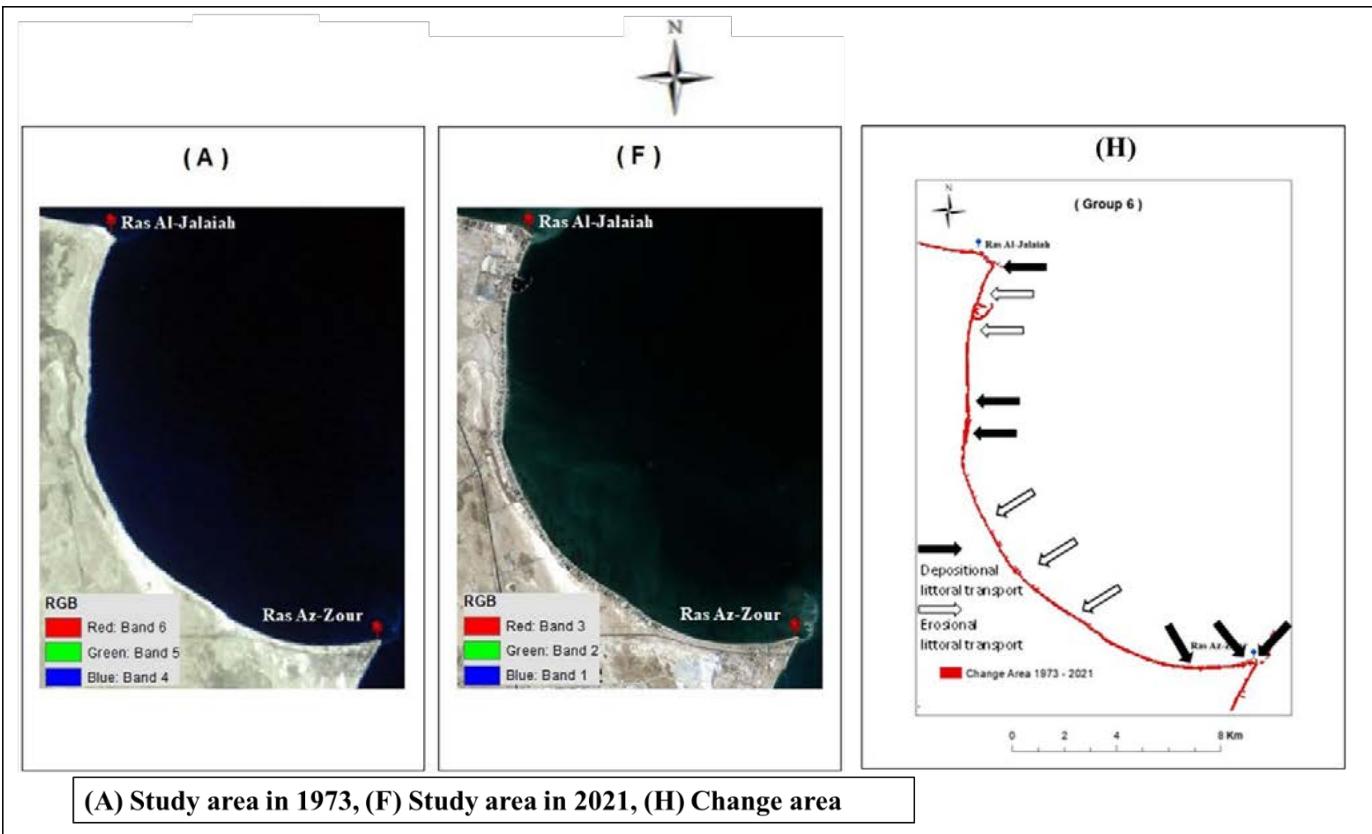 Fig. 12: Maps of the study area in the total time-period group (6): (A) Study area in 1973, (F) Study area in 2021, and (H) the total area subjected to change along the shoreline during the 48-years period (1973-2021).
## V. CONCLUSIONS
Analyzing the changes in the shoreline of the study area over 48-years period using GIS, remote sensing data, and calculations using the GIS applications, provided conceptual knowledge of the littoral sand debris transport along the shoreline of the study area through locating areas of deposition and erosion. During the different time-periods groups the shoreline of the study area witnessed alternating episodes of deposition and erosion at different rates.
The two large depositional sand spits near the headlands of Ras Al-Julaiha and Ras Az-Zour formed due to the forces of tidal currents around these two headlands. These sand spits are not regularly developed and are not exactly of the same direction as the shoreline before it bends. In the central part of the area, few beach cusps, changed their shape between 1973 to 2021 possibly due to long-shore current activity. The total area subject to change along the shoreline during the 48-years period (1973-2021) was about $(98068.3\mathrm{m}^2)$ $3.4\mathrm{km}^2$ and the length of the shoreline has increased successively from $(74520\mathrm{m})$ $74.5\mathrm{km}$ in 1973 to $(86403.2\mathrm{m})$ $86.4\mathrm{km}$ in 2021.
The changes were mostly in the southernmost Ras Az-Zour headland and the central part as well as the northernmost of Ras Al-Julaiha. The changes in the tip of the two promontories and the central part of the study area are mainly due to the deposition of aeolian sediments and the littoral debris drift by the northeasterly-southwesterly prevailing longshore current. In addition, the anthropogenic activities in the study area, such as Az-Zour oil refinery project in the southernmost part of Ras Az-Zour headland, which is considered as a kind of land reclamation, which causes changes to the coastal morphology of this section, as well as, the shape of the shoreline between 1973 to 2021. Moreover, any actions taken in the neighboring countries or in the vicinity of shorelines can directly or indirectly affect the morphology of the shorelines, such as the environmental catastrophe occurred due to the drainage of the central marshes in Iraq during the 1990s.
According to such changes in the shoreline position would help the integrated management policies in protecting or taking mitigation measures to protect those locations which may subject erosion and consequently considerable infrastructure loss.
The outputs of this study would provide a comprehensive vision of the impact of the intervention and interaction between the anthropogenic activities and the ongoing natural coastal processes in changing the geomorphology of the shorelines. This study could be of good aid in preparing sustainable integrated management plans for such vulnerable coastal sites that are planned to be used for utilities, recreational, touristic, or developmental plants either in Kuwait or other regions worldwide of similar characteristics and protect them from the adverse implications of beaches loss or shoreline frequent position change.
## ACKNOWLEDGEMENT
The authors would like to thank the USGS for providing Landsat images, and Mrs. Said for her participation in finalizing the introduced figures.
Generating HTML Viewer...
References
51 Cites in Article
M Abou‐seida,Mohamed Al‐sarawi (1990). Utilization and management of coastal areas in Kuwait.
Najeeb Aladwani (2022). Shoreline change rate dynamics analysis and prediction of future positions using satellite imagery for the southern coast of Kuwait: A case study.
T Al-Asfour (1978). The marine terraces of the Bay of Kuwait.
T Al-Asfour (1982). Changing sea-level along the North coast of Kuwait Bay.
D Al-Bakri,F Khalaf,A Al-Ghadban (1984). Mineralogy, genesis and sources of surficial sediments in the Kuwait marine environment, northern Arabian Gulf.
D Al-Bakri,W Shublaq,Z Al-Sheikh,W Kittaneh (1985). Sensitivity of the Kuwait Coastal Environment to Potential Oil Spill Impact.
A Alesheikh,A Ghorbanali,N Nouri (2007). Coastline change detection using remote sensing.
A Al-Ghadban (1980). Recent shallow water sediments in the area between Ras Al-Jalay'ah and Ras Al-Zour.
A Al-Ghadban (1990). Holocene sediments in a shallow bay, southern coast of Kuwait, Arabian Gulf.
A Al-Hurban,R Misak,A Al-Ostad (1996). SUSCEPTIBILITY OF TERRAIN UNITS TO DUST DEFLATION AT RAS AZ-ZOR AREA, SOUTHERN KUWAIT.
A Al-Hurban,I Gharib (2003). Geomorphological and sedimentological characteristics of coastal and inland sabkhas, Southern Kuwait.
A Al-Hurban,I Gharib (2004). Geomorphological and sedimentological characteristics of coastal and inland sabkhas, Southern Kuwait.
Adeeba Al-Hurban,Maryam Al-Shimmari (2008). Geomorphological Changes by the Action of Coastal Processes and Anthropogenic Activties along the Coastal Zone between Ras Al-Jalaiah And Ras Az-Zour, Southern Kuwait.
A Al-Hurban,R Misak,A Al-Ostad (2009). SUSCEPTIBILITY OF TERRAIN UNITS TO DUST DEFLATION AT RAS AZ-ZOR AREA, SOUTHERN KUWAIT.
Adeeba Al-Hurban,Hamdy El-Gamily (2013). Geo-Historical and Geomorphological Evolution of the Sabkhas and Ridges at the Al-Khiran Area, State of Kuwait.
Adeeba Al-Hurban (2014). Effects of recent anthropogenic activities on the surface deposits of Kuwait.
M Al Mukaimi,K Kaiser,J Williams,T Dellapenna,P Louchouarn,P Santschi (2018). Centennial record of anthropogenic impacts in Galveston Bay: Evidnece from trace metals (Hg, Pb, Ni, Zn) and lignin oxidation products.
Mohammad Al Mukaimi,Timothy Dellapenna,Joshua Williams (2018). Enhanced land subsidence in Galveston Bay, Texas: Interaction between sediment accumulation rates and relative sea level rise.
S Al-Rashidi,A Al-Hurban (2019). Geomorphological changes along the coastline of As Sabriya, northern Kuwait.
M Al-Sarawi,A Al-Zamel,I Al-Rifaiy (1993). Late Pleistocene and Holocene sediments of the Khiran area (South Kuwait).
Jawad Al-Sulaimi,S El-Rabaa (1994). Morphological and morphostructural features of Kuwait.
Philippe Bouysse,Robert Horn,Francis Lapierre,François Le Lann (1976). Étude des grands bancs de sable du Sud-est de la mer Celtique.
(1994). CIA, Report, Iraq ::Foreign Intelligence and Security Services, August 1985, Secret, CIA..
H Clarke (1988). Stratigraphy and rock unit nomenclature in the oil-producing area of interior Oman.
Keith Dyer,David Huntley (1999). The origin, classification and modelling of sand banks and ridges.
Rhodes Fairbridge (1961). Eustatic changes in sea level.
Donald Holm (1960). Desert Geomorphology in the Arabian Peninsula.
J Houbolt (1957). Surface sediments of the Persian Gulf near the Qatar Peninsula.
John Jensen,Kalmesh Lulla (2015). Introductory digital image processing: A remote sensing perspective.
W Jung,B Suk,G Min,Y Lee (1998). Sedimentary structure and origin of a mud-cored pseudo-tidal sand ridge, eastern Yellow Sea, Korea.
P Kassler (1973). The Structural and Geomorphic Evolution of the Persian Gulf.
F Khalaf,M Ala (1980). Mineralogy of the Recent intertidal muddy sediments of Kuwait — Arabian Gulf.
F Khalaf,D Al‐bakri,A Al‐ghadban (1984). Sedimentological characteristics of the surficial sediments of the Kuwaiti marine environment, northern Arabian Gulf.
F Khalaf,I Gharib,M Al-Hashash (1984). Types and characteristics of the recent surface deposits of Kuwait, Arabian Gulf.
Zdenek Kukal,Adnan Saadallah (1973). Aeolian Admixtures in the Sediments of the Northern Persian Gulf.
G Lees,Reginald Smith,N Kinnear (1928). The Physical Geography of South-Eastern Arabia.
Z Liu,D Xia,S Berne´,K Wang,T Marsset,Y Tang,J Bourillet (1998). Tidaldepositional systems of China's continental shelf, with special reference to the eastern Bohai Sea.
M Mohammed (1978). Preliminary marine geological studies on recent sediments of Kuwait Bay.
Mamdouh Mohamed,Ali Al-Shamlan (1977). The factors controlling the distribution of carbonate content in Kuwait Bay sediments.
T Off (1963). Rhythmic linear bodies caused by tidal currents.
S-C Park,B-H Lee,H-S Han,D-G Yoo,C-W Lee (2006). Late Quaternary Stratigraphy and Development of Tidal Sand Ridges in the Eastern Yellow Sea.
H Partow,R Witt,G Fosnight,A Singh,Ron Witt,D Del Pietro (2001). The Mesopotamian Marshlands: Demise of an Ecosystem in: Early Warning and Assessment Technical Report.
Fatma Bahman,Fowzia Abdullah,Abbas Saleh,Hossein Alimi (1977). Organic geochemical and petrographical characteristics of the major lower cretaceous petroleum source rock (Makhul Formation) in Kuwait - Arabian Gulf.
Frantisek Picha (1978). Depositional and diagenetic history of Pleistocene and Holocene oolitic sediments and sabkhas in Kuwait, Persian Gulf.
Yoshiki Saito,Hajime Katayama,Ken Ikehara,Yoshihisa Kato,Eiji Matsumoto,Kazumasa Oguri,Motoyoshi Oda,Mariko Yumoto (1998). Transgressive and highstand systems tracts and post-glacial transgression, the East China Sea.
A Saleh (1975). Pleistocene and Holocene oolitic sediments in the Al-Khiran area.
E Seibold,L Diester,D Fütterer,H Lange,P Müller,F Werner (1973). Holocene Sediments and Sedimentary Processes in the Iranian Part of the Persian Gulf.
E Shinn (1973). Recent Intertidal and Nearshore Carbonate Sedimentation around Rock Highs, E Qatar, Persian Gulf.
A Stride (1982). Ancient offshore tidal deposits.
Y Youash (1984). COMMON NON-METALLIC ORES.
(2018). Kuwait Integrated Petroleum Industries Company to expand Al-Zour refinery with Honeywell technology.
No ethics committee approval was required for this article type.
Data Availability
Not applicable for this article.
How to Cite This Article
Adeeba Al-Hurban. 2026. \u201cGeomorphological Changes by the Action of Coastal Processes and Anthropogenic Activties along the Coastal Zone between Ras Al-Jalaiah And Ras Az-Zour, Southern Kuwait\u201d. Global Journal of Human-Social Science - B: Geography, Environmental Science & Disaster Management GJHSS-B Volume 23 (GJHSS Volume 23 Issue B2).
Explore published articles in an immersive Augmented Reality environment. Our platform converts research papers into interactive 3D books, allowing readers to view and interact with content using AR and VR compatible devices.
Your published article is automatically converted into a realistic 3D book. Flip through pages and read research papers in a more engaging and interactive format.
Our website is actively being updated, and changes may occur frequently. Please clear your browser cache if needed. For feedback or error reporting, please email [email protected]
Thank you for connecting with us. We will respond to you shortly.
Lorem ipsum dolor sit amet, consectetur adipiscing elit. Ut elit tellus, luctus nec ullamcorper mattis, pulvinar dapibus leo.
Geomorphological Changes by the Action of Coastal Processes and Anthropogenic Activties along the Coastal Zone between Ras Al-Jalaiah And Ras Az-Zour, Southern Kuwait