In this paper, we briefly analyze four reasons for the generation of large outbursts of positively charged particle fluxes in the Earth’s interior during the gestation period of large earthquakes, and propose a physical mechanism for the formation of an EMB (electromagnetic umbrella) model of the difference between the concentration of positive and negative charged particle fluxes, which can be used to explain the relationship between a mega-meteorological catastrophic event and the generation of excessive charged particle fluxes from the lithosphere prior to the large earthquakes. Causality. We compare some historical records of major earthquakes of magnitude 7.5 around the world, and find that the correlation between megameteorological hazard events and large earthquakes has a good fit. Based on this statistic, in this paper, we take three large earthquakes, Wenchuan, May 12, 2008, Fukushima, Japan, March 11, 2011, and Turkey, Feb. 6, 2023, as case studies, to explore the way to assist in locating the epicenter of major earthquakes by reverse tracking method using the major meteorological disaster events
## I. INTODUCTION
The earliest Chinese scholar to study the relationship between meteorological events and earthquake precursors was Geng Qingguo, a former staff member of the China Earthquake Administration, whose ideas are also known as the drought theory.(1) His analysis of the correlation between droughts and earthquakes was questioned and criticized by many later researchers because he used only crude and simple statistical calculations and did not reveal the deeper geophysical mechanisms.(2) In 2023, Indian scholars like Bikash Sadhukhan and others comprehensively evaluated the results of academics in earthquake precursors, which mentioned that a number of studies have found a close relationship between seismic events and climate anomalies, including drought, precipitation, and so on. (2) We agree with the view that data on climate anomalies can be used as an aid in predicting earthquakes as precursors. Meteorology, as a well-established discipline with well-developed theories, is able to predict climate change quite accurately by using meteorological satellite imagery, such as changes in temperature, barometric pressure, cyclones and atmospheric circulations, and the stresses induced by precipitation, barometric pressure, and snow accumulation. However, it is not easy to come up with convincing data to prove that meteorological anomalies are precursors of major earthquakes, as it is well known that the major factors determining climate variability are very complex, and it is difficult to completely exclude the interplay of astronomical, geophysical, anthropogenic industrialized greenhouse gas emissions and other factors.
In the past decade, the theoretical analysis of electromagnetic signals of earthquake precursors by scholars all over the world has been quite abundant, and the research on the dipole theory of the formation of the Earth's interior, the anomalous changes of geoelectricity and geomagnetism, the signals of low-frequency electromagnetic waves of ULF and VLF, the thermal anomalies of the land and the ocean, and the phenomenon of the Earth's "air-jet" has already provided prospective research results for the correlation study between meteorological hazards and large earthquakes. These studies have provided prospective research results for us to propose the correlation between meteorological hazards and major earthquakes. (3)
One of the main means of studying earthquake precursors in seismic electromagnetism is mainly through NOAA polar-orbiting satellites to monitor data on the time correlation between global electron fluxes and earthquakes, and the study of global electron density (TEC) and low-frequency electromagnetic wave anomalies, which have become the two main research routes for the discovery of earthquake precursors. (4) (5) On the other hand, the latest progress in geophysics of solid geophysical-chemical data from exploration in the depths of the earth, the study of high electrical conductivity of the oceans and lithosphere in localized territories, and the release of heat energy from radioactive elements, etc., have revealed from different sides that during the brewing of earthquakes it is not only the movement of the mechanical mechanics of plates that is traditionally studied by geology, but also the movement of the plates during the brewing of earthquakes, from the thermodynamics, particle physics, and electromagnetism of the Instead, it provides evidence of the existence of various earthquake precursor signals from thermodynamics, particle physics, electromagnetism, and other fringe sciences, as well as from the interdisciplinary study of the lithosphere-ionosphere-sun magnetic field. Electromagnetism studies of earthquakes have opened up an original way of thinking in the search for a relationship between global mega-climate anomalies and large earthquakes.
The causes of global anomalous climate disasters can usually be simplified into three factors, 1) the disruption of the self-circulating state of the atmospheric circulation between the Earth and the oceans, 2) cosmic ray factors (e.g., sunspots affecting the Earth's droughts), and 3) factors of human industrialization;
The most talked about topic affecting global climate change in the international community and academia is the excessive greenhouse gas emissions of carbon dioxide and methane resulting from the accelerated industrialization of mankind. It is undeniable that the accelerated industrialization of mankind in the second half of the 19th century contributed to the rise in global atmospheric temperatures, but to attribute greenhouse gas emissions or climatic changes such as high-temperature heat waves and extreme rainstorms and snowstorms to the factors of industrialization of mankind has a large element of wishful thinking and subjectivity.
We propose that the fourth factor influencing the climatic anomaly, the effect of large earthquakes, is the difference in the concentration of fluxes of positively and negatively charged particles formed in the lithosphere and spilled out over the surface during the gestation period of large earthquakes of magnitude 7.5 or greater.(6) This contributes positively to the occurrence of megathrust events. meteorological hazard events with a positive contribution. (Volcanic eruptions and hurricanes have been excluded as influences on mega weather anomalies in order to simplify the research in this paper.)
Based on our long-term experience in actual earthquake prediction and observation of earthquake precursors, we have constructed an EMB (Electromagnetic umbrella) model of the relationship between mega-meteorological catastrophic events and seismic electromagnetism. Note: EMB is the abbreviation for the distribution of charged particle fluxes within the Earth in the atmosphere as an umbrella-shaped state.
The basic elements of the EMB model are expressed below:
Prior to a major earthquake, the thin lithosphere beneath the earth's surface produces a much higher than normal flux of positively charged particles within the earth's surface due to stresses and high temperatures, high pressures, and some unknown particle physics, creating a difference in the concentration of positive and negatively charged particle fluxes. (7) Positively charged particle fluxes in excess of "supply" rise from the land and ocean to the sky, which in turn affects dramatic climate change. Thus, a mega-meteorological disaster is not only defined as a climatic upheaval, but is likely to have a fairly significant correlation with the precursor characteristics of a major earthquake.
First of all, we limit the term "extreme meteorological anomalies" to "extreme droughts and extreme rainstorms and snowstorms that have not occurred in a geographical area of the Earth for more than 50 years". The reason for adopting such a quantitative criterion not only comes from the observation of statistical significance, but also because we recognize that it is difficult to exclude all kinds of meteorological factors affecting climate change from the definition of "extreme meteorological anomalies". It is difficult to rule out meteorological factors affecting climate change, and only a mega-meteorological hazard event that has not been encountered for 50 years could have a statistically significant causal relationship with the electromagnetic precursors of earthquakes in the gestation period of earthquakes of magnitude 7.5 or greater.
The accuracy and immediacy of the data in the European Swarm satellites, which currently monitor earthquake precursor characteristics around the globe, depend on the time of day that the satellite observing conditions circle the Earth and the degree of transparency of the atmospheric clouds, and do not always monitor the anomalies of earthquake precursors. In meteorological satellites, there are two particles, electrons to the east and positrons to the west, and if meteorological satellites can measure the positive and negative charge fluxes of different particles in the total number of charged particles, respectively, it will provide a more solid foundation for our EMB model. However, the limited number of meteorological satellites over the Earth does not allow for the observation of electron density variations on the surface and in space every minute, and it also appears that no satellite observation technique has been developed that can instantly distinguish the respective differences in the fluxes of positively and negatively charged particles in the global TEC density anomalies, and thus it is difficult to advance the study of the correlation between atmospheric fluctuations and earthquake precursors. (8) (9) In view of this, this paper only analyzes the mechanism of EMB formation on a purely physical level and theoretically;
It is assumed that the positively charged particle flux definitely exceeds the negatively charged particle flux during the preparatory phase of a major earthquake, creating an umbrella-shaped state of distribution of charged particle flux in local space. A large flux of charged particles escaping from thin lithospheric cracks, metaphorically speaking, if these charged particles rise from the subsurface into the atmosphere in a direction similar to the umbrella handle, the positively charged particle flux would normally occupy the center of the umbrella of the EMB, while the negatively charged particle flux would be distributed at the edges of the umbrella.
There are four main reasons why the positively charged particle flux absolutely exceeds the negatively charged particle flux concentration difference during the preparation phase of a major earthquake:
Geophysical exploration data and dipole theory have demonstrated that large igneous rocks in plates can produce positrons in large quantities at high temperatures and pressures; (10) (11)
A large number of radon and helium concentrations increase rapidly before a major earthquake, seismologists called the so-called Earth "jet" phenomenon, has been regarded as a more reliable earthquake precursors, the radioactive element uranium 238 is prevalent in granite, melting granite magma state is no exception, the $\beta$ -decay of uranium 238 produces radioactive isotopes of radium-226, and half-decay produces intermediate radon-222 itself is unstable, it will release positively charged alpha particles. while half-decay produces the intermediate radon-222, which is inherently unstable and releases positively charged alpha particles; therefore, there is a direct correlation between the increase in radon and helium concentrations prior to major earthquakes and the overproduction of fluxes of positively charged particles; (12)
Cosmic high-energy protons penetrate deep beneath the earth's surface and strike the nuclei of atoms within rocks, causing them to lose their electrons and producing large numbers of positrons;
Plasma waves and Alfven isolated waves formed in melt-hot, highly magnetic material in the soft rheosphere-lithosphere have the potential for small-scale magnetic reconnection locally and accelerated electron clusters, generating clusters of positively charged particles and continuously accelerating electron momentum. (13)
Self-reinforcing positive feedback mechanisms for positively charged particle fluxes:
In accordance with the dipole mechanism of the large igneous rupture gap in the lithosphere, the positively charged particle flux generated, penetrating the surface of the thin lithosphere rises to the low altitude, in general, the top of the clouds in the atmosphere for the positively charged particle flux, and the bottom of the clouds for the negatively charged particle flux, when the concentration of positively and negatively charged particle flux is basically the same, the positively charged particles in the upper end of the high-altitude cloud layer will be subjected to the negatively charged particles of the low altitude cloud layer Attraction, the combination of positive and negative charges in the water vapor molecules is a necessary condition for the formation of CNN (cloud condensation nucleation), that is, for the second law of thermodynamics in the reversible space state, the entropy does not increase overall. And the formation of a large number of heavier and colder droplets produces rain clouds. The necessary condition is the overall equilibrium of the flux of positive and negative charged particles in the atmosphere, and if a huge local difference in the concentration of the flux of charged particles occurs, a climatic anomaly with a very unbalanced regional distribution of extraordinarily large droughts and torrential rains and snowfalls is produced. In the soft flow circle - lithosphere can form plasma material containing metal minerals, in a strong magnetic field, high-speed movement by the Lorentz force, resulting in the separation of positive and negative charges, is ionized by a large number of positively charged particles flow, penetrate the surface of the thin lithosphere into the atmosphere. From the properties of the Alvin wave, we can assume that positron or positively charged in the acceleration, if not and negatively charged ions combined annihilation, will certainly produce high heat temperature change.
Here it is necessary to differentiate the process of formation of fluxes of positively and negatively charged particles in different environments on land and in the oceans, and it is also necessary to classify two types of earthquakes, continental and oceanic. It is obvious that large earthquakes on land and large earthquakes on the ocean floor of the ocean have different physicochemical modes of generation of fluxes of positive and negatively charged particles, and different contribution factors to the fluxes of positrons and positively charged particles.
In the thin lithosphere beneath continental plates, large igneous provinces and highly conductive magmas, large clusters of charged particles are generated and enter the atmosphere, and these large clusters of charged particles enter trace gases, which have the greatest proton affinity, and react with aerosols in complex chemical reactions. Clusters of charged particles, originally distributed haphazardly in the atmosphere, collide with water vapor to form water vapor clouds and aerosols, mainly with sulfate. According to the geographical area of the earthquake, earthquakes can be divided into two types: land earthquakes and ocean earthquakes. Since the EMB is the process of a large outburst of charged particle flux in the preparatory stage of a large earthquake, the flux of positively charged particles rises along the direction of the EMB, which is also compared to as the "Along the vertical upward direction of the umbrella handle", in above the top of the "EMB", therefore it is reasonable to expect that the Poisson distribution in the center of the "EMB of positively charged particles in the center of the EMB is a natural physical phenomenon.
Meteorological hazards characterized by large earthquakes on the continent are mainly mega-droughts:
As a result of the internal changes in the lithosphere during the gestation period of a major earthquake, an excess flux of positively charged particles was generated, the flux of negatively charged particles in the low altitude of the earth's surface was not sufficient to attract positive and negative charges to form a neutralization of the electric elimination, and the excess flux of positively charged particles accelerated with the warm air currents to rise to the high altitude and produce more positively charged particle clusters due to the impact of the high-energy proton streams generated during the solar flares and black-son outbursts, due to the positively charged protons. Solar flares or blackouts produce cosmic proton streams in the atmosphere, which impact and repel each other with clusters of charged particles in the atmosphere, producing a net increase in the atmospheric flux of total positively charged particles due to the constant stripping of electrons from the atomic structure of compounds contained in the water vapor. When the positrons move in the same direction as the atmospheric electric field, the velocity vector of the positrons accelerates and the opposite decelerates. When upward and downward convection of the atmosphere occurs, the warm air stream moves upward, at which point the positively charged particles are driven by the direction of the solar electric field force and move in the same direction as the warm air stream, accelerating upward. Due to the mutual exclusion of positrons and positively charged particles, only the formation of small condensation nodules molecules, it is easy to be dried by solar radiation, becoming a high-pressure hot dry air, preventing the central position of the EMB umbrella low-pressure cold air into the slightly moist air mass down and constantly be dried for the rise of the dry hot air mass when the EMB umbrella type of the formation of the internal pressure is greater than the outside, to prevent the outside of the humid air cloud into the, so called sinking adiabatic. This is the so-called heat dome phenomenon of sinking adiabatic heat. This results in a catastrophic drought in a certain geographic area. This is also in accordance with the second law of thermodynamics, which states that entropy increases monotonically and marginally in an irreversible space.
In plain language, the electromagnetic changes during the brewing period of the great earthquake were extreme and abnormal, forming a huge and incomparable EMB umbrella over the earth's surface, and the positively charged particles generated in the lithosphere were vertically upward along the EMB "umbrella handle", and excessive positively charged particles gathered and distributed around the center of a certain localized space in the atmosphere. The flux of superheated gases in the center of the EMB prevents the formation of heavy rain and snow clouds in the lower part of the atmosphere covered by the EMB, resulting in extreme heat and droughts that do not occur for decades.
Thus, the occurrence of a mega-drought event that has not been encountered in a geographic area for 50 years is a distinctive feature of the production of an excess flux of positively charged particles in the extrusion of the continental plate prior to a major earthquake.
### EMB generation mechanism for the ocean:
The climate anomaly of oceanic earthquakes is much more complex than the impact of land-based earthquakes on the climate. Meteorologists analyze that the contribution of the ocean to the warm and humid air clouds in the atmospheric circulation is mainly a chain of chemical equilibrium, as follows: abundant planktonic microorganisms in the ocean decompose decaying organisms in the ocean, and the decomposition of the residue produces dimethyl sulfide (DMS) gas, which is the major volatile sulfide emitted by the ocean and accounts for about $95\%$ of the oceanic sulfur emissions. DMS is the main volatile sulfide emitted from the ocean, accounting for about $95\%$ of ocean sulfur emissions, and DMS emitted from the ocean to the atmosphere accounts for about $50\%$ of the natural sulfur emissions to the atmosphere, and is the most important volatile sulfide. The DMS in seawater enters the atmosphere, where it undergoes a series of oxidations to generate methylsulfate and non-sea salt sulfate aerosols. Since sulfate aerosols are an important component in the generation of cloud condensation nuclei, non-sea salt sulfates increase the number of cloud condensation nuclei and increase the density of cloud droplets. A team of researchers led by aerosol physicist Benedet Weisel of the University of Vienna, who revealed data on the formation of global particles covering 40 percent of the Earth's surface through a global circumnavigation of complex airborne meteorological monitoring instruments, found that a new chemical, hydroperoxy methylthiocarbonate (HPMTF), in the DMS is converted to sulfate aerosols, which readily dissolves into the water droplets of existing clouds, thus permanently removing the sulfur.36% of the sulfur in DMS is lost to clouds in the manner described above, and the other $15\%$ is lost through other processes. Thus, less than half of the sulfur released by marine plankton contributes to cloud formation. (14) (15)
Aerosol scientists studying the atmosphere and oceans are further investigating the properties of the new chemical, HPMTF, and there are still many unknowns. From the chemical equation of HPMTF, the chemical formula of this new chemical substance has a head of hydroperoxy (HOO-), hydroperoxy radical is an important reactive agent in atmospheric chemical reactions, and other compounds combined with other compounds between the main electrostatic and orbital interaction is mainly dominated by the loss of one or a few electrons easily, and the characteristics of positron and positively charged particles are very similar. Experiments have shown that H2O2 is readily soluble in water and can remove sulfur S in DMS, (16) and CO gas from subsurface gas mines can naturally synthesize methyl thiocarbamate, a very stable organic chemical isomer. (17) Upon combination of hydrogen peroxide radical and methyl thiocarbamate, both sulfur and sulfate aerosols are anionic negatively charged particles properties, and mutual attraction of positively and negatively charged charged particles is a necessary physical condition for cloud condensation nucleation (CNN) generation. Based on the chemical reaction process that HPMTF easily dissolves in the water vapor of fine clouds and then removes sulfur, if our hypothetical EMB model can be valid for describing the formation of an absolute excess of total positively charged particle fluxes and densities under the surface during the brewing period of major earthquakes, the so-called difference in the concentration of positively and negatively charged particle fluxes is precisely the culprit behind the abnormal and drastic changes in the global climate. Then, it can be boldly hypothesized that the charged nature of this new chemical substance HPMTF, which is newly produced in the ocean, may be affected by the disturbing factor of the increasing flux of positronic particles before the great earthquake, and formed the cationic property of high electronegativity over the ocean, which ended the physicochemical process of converting most of the DMS into anionic compounds ahead of time, and thus greatly reduced the non-sea-salt sulfate aerosol production rates.
Characteristics of meteorological anomalies of oceanic earthquakes: As a result of large earthquakes under the oceanic crust of the ocean floor in the gestation period, high temperature and high conductivity of the magma and plate extrusion of multiple factors, resulting in the generation of seawater warming to the generation of adverse to the production of plankton dms to the anionic sulfate aerosol direction, the surface of the oceans and seawater generated by the negatively charged particles is not enough to and the positively charged particles flux to the combination of the neutral large droplet cloud, thus The positively charged or cationic compounds and aerosols are carried aloft by the oceanic monsoon to drift along the stratosphere to the northern and southern hemispheres of the Earth, resulting in disruptions in the atmospheric circulation or a country's geographic area of extreme drought and precipitation anomalies in the distribution of the formation of winter blizzards, the formation of summer rainstorms. Unusually hot weather and hot sea water are also formed.
Discounting climate change under normal conditions, as originally estimated by scientists, earthquakes and volcanoes account for only 5 percent of the global geothermal energy in global heat, generating about 46 trillion watts (46 terawatts or TW) of heat energy from the subsurface, with 2 TW of that coming from volcanic eruptions and earthquakes. (18) With the exception of earthquakes and volcanic eruptions, most of the geothermal flux is released as continuous geothermal flow. This is likely to underestimate the thermal energy generated by the accelerated half-life of nuclear decay isotopes such as U-235, U-238, and Thorium and Potassium incorporated into flowing magma during the pre-earthquake gestation period, the subsequent extension of the large mantle column plume into the seismic zone of the thin lithosphere, and the generation of excess positrons in the rock voids, as well as the accelerated half-life of nuclear decay isotopes such as U-235, U-238 and Thorium and Potassium. At the same time, the possibility of plasma wave generation in high conductivity subsurface fluids and localized magnetic reconnection on small scales beneath the surface cannot be ruled out, and it is likely that all four of the above reasons for generating the Earth's heat will multiply the effects of large earthquakes and volcanic eruptions on the release of geothermal energy into the atmosphere.
Making a comparison of the historical data related to mega meteorological disasters and large earthquakes, we find cite Schedule, 1876-1879 North China suffered a great drought, July 1, 1879 A.D. On July 1, 1879, a large earthquake of magnitude 8.0 occurred in Wenxian County, Gansu Province. 1920, the northern provinces of China, such as Shandong, Henan, Shanxi, Shanxi, Shaanxi and Hebei, suffered a great drought not seen for more than 40 years. In 1920, Shandong, Henan, Shanxi, Shaanxi, Hebei and other provinces in northern China suffered a drought that had not been seen for more than 40 years, and on December 16, 1920, an 8.5-magnitude earthquake struck Haiyuan County in Ningxia, China. 1928-1930, Northwest China suffered a century-old drought, centering on Shaanxi, forming a drought-stricken area that accounted for nearly two-thirds of the entire land area of China. The drought lasted for three years, and on December 25, 1932, a 7.6-magnitude earthquake struck Changmabao, Gansu Province, killing and injuring more than 70,000 people, while the 7.8-magnitude earthquake in Tangshan, China, in 1976 was preceded by a major drought in northern China. (19) In 1998, a magnitude 7.1 earthquake occurred off the northern coast of Chile. Although this year of the Great Drought in Chile was more severe than the years
shown earlier, the fact that only strong earthquakes of less than magnitude 7.5 occurred seems to be a paradox in the continental seismic pattern of the EMB model. However between 1998-2001. Two magnitude 8 and 8.4 occurred off the coast of Peru, which is part of the same South American seismic plate as Chile. It was also demonstrated that there is a good fit between mega-droughts and precursors of large earthquakes. According to the records of the World Meteorological Organization (WMO), the period between 1997 and 1998 was the worst year of El Niño in the 20th century, and the average temperature of the ground and sea level in that year was only 0.4 degrees Celsius higher than the average temperature of 16.5 degrees Celsius of the 30-year period from 1961 to 1990; and for all of the year of 1998, the global temperature of the land and the ocean was 0.7 degrees Celsius higher than the 1997 average temperature of 0.7 degrees Celsius. cite https://www.pmel.noaa.gov/elnino/what-is-el-nino. 而 1997-2001 年 Six major earthquakes of magnitude 8 or greater occurred globally, including two major earthquakes in Peru exceeding magnitude 8, and one each in the southern Indian Ocean and Turkey exceeding magnitude 8, all of which had the potential to greatly affect the countries in the seismic zone of atmospheric and oceanic circulation in the east-central equatorial Pacific. If one assumes that the EMB model of oceanic precursors to large earthquakes that can affect the climate along the Pacific coast of the eastern and western hemispheres can be self-consistent, then the two magnitude 8.4-8.6 mega-earthquakes that occurred in Indonesia on the morning of April 11, 2012, including the strong 6.9 magnitude earthquake that struck the U.S. off the coast of California in 2012, can be reconciled even with the resultant El Niño phenomenon and the 2012 U.S. largest earthquake of magnitude 8 or greater since the hottest and driest meteorological disaster event since meteorological records began in 1895, (20) Cite earthquake information from the German Seismological Network: http://geofon.gfz-potsdam.de/ eqinfo/list.php
We have done rough statistics based on the correspondence between some of the global historical records of large 7.5-magnitude earthquakes and mega droughts and heavy rain and snowfalls, and mega meteorological hazard events are formed on average from half a year to 3.5 years before the occurrence of large earthquakes in advance, and there seems to be a more convincing correlation between mega meteorological hazard events that do not occur once every 50 years and the precursors of large earthquakes with a more persuasive correlation of statistical fit. Yet the reasoning that mega-meteorological catastrophe events are precursors of large earthquakes based solely on such a simple enumeration of juxtapositions is sure to be met with the same criticisms of Geng Qingguo's drought-earthquake modeling that have been made previously by fellow seismologists. It is also and likely to be strongly challenged by meteorologists.
It is known that even if it occurs in the center of the magnetic umbrella, the formation of dense clusters of positron particles causes a mega-drought that corresponds directly to the epicenter of the umbrella in the vertical direction of the umbrella's handle. However, large earthquakes occurring directly below the center of the magnetic umbrella are exceptional. That is, the simplest EMB model. Earthquake forecasters have not always been so lucky as to encounter megadroughts in areas where the epicenters of large earthquakes occur in almost the same geographic location. The atmospheric circulation is influenced by the oceanic monsoon, and the spatial state of the positively charged particle flux forming the EMB is constantly shifted with the atmospheric circulation, as if the magnetic umbrella created in the region of the large earthquakes is drifting through the stratosphere.
Therefore, in reality, just using the occurrence of a large meteorological disaster event as a precursor to a large earthquake, although there are meteorological records that do not occur in 50 years and the occurrence of large earthquakes of magnitude 7.5 or more corresponds to the time and magnitude of the two elements of the three elements of the earthquake prediction, the most difficult is how to predict the epicentral range of the large earthquakes?
In the following, we start from the Wenchuan 7.8 magnitude earthquake in China in 2008, and specifically reveal the idea of the backtracking method in the EMB model applied to the medium-term prediction of large earthquakes.
In May 2008, a 7.8 magnitude earthquake struck the Wenchuan region of Sichuan, China, a strong continental-type earthquake typical of the Eurasian continental plate squeezed by the Indian Ocean plate. In terms of unusual meteorological events prior to the earthquake, in 2007, China experienced a 60-year drought in Gansu, a 100-year drought in Heilongjiang, a severe high-temperature drought in Jiangnan and South China, and a 50-year drought in the fall that lasted until early winter. Special drought occurred in some parts of Sichuan, and in early 2008, Hunan and Jiangxi in southern China were hit by a huge blizzard. (21) (22) According to the magnetic umbrella EMB model, at least these mega-meteorological anomalies in mainland China were precursors to major earthquakes.
However, over a wide area spanning thousands of kilometers, it is critical to determine the extent of the epicenter.
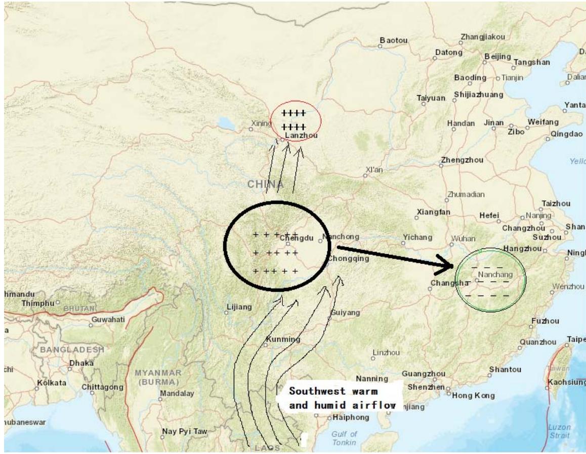
According to the central location of the umbrella state geography of the EMB, the predicted positioning of the epicenter of a large earthquake should first correspond to the region of the eruption of the flux of positively charged particles of the straight-up type under the c umbrella handle, i.e., Sichuan, Gansu, and Heilongjiang;
First, the water vapor generated in the Indian Ocean moves northeastward through the southwest monsoon, forming the Southwest Warm and Humid Current (Bay of Bengal Warm and Humid Vapor). As the Himalayan mountain system blocks part of the northern cold air from going directly southward and pushes the cold air along the northern side of the mountain system to extend to the eastern land, the southwestern warm and humid airflow enters into the hinterland of China through the southwestern part of the country, and it is an inevitable route that dominates the significant precipitation in the hinterland of northwestern China and northern China. According to the Chinese hinterland precipitation conditions in a large degree depends on the southwest warm and humid airflow into the route, can not be simply the occurrence of a mega-drought in Gansu has the potential to occur in Gansu, Ningxia, as a simple link to a large earthquake prediction basis. And from Gansu and Heilongjiang have appeared more than 50 years do not meet the mega-drought meteorological disaster event analysis, Heilongjiang to Gansu, the distance of 2697.5 kilometers, in mainland China, the two places so far apart, it is unlikely that two 7.5 magnitude earthquakes at the same time probability of seismic precursors above the large earthquake. Therefore, the possibility of a possible epicenter of a large earthquake must first be ruled out from these two provinces.
Since in 2007 and early 2008 China appeared to be in line with the EMB model of the precursor of large earthquakes in large meteorological disasters, can not simply use the occurrence of large drought in the region of the inevitable existence of large earthquakes in a simple way of thinking, the epicenter of the epicenter is located in Gansu or Heilongjiang, we have to be generated from the EMB model of large meteorological disasters, reverse tracking of large earthquakes in the epicenter of the range. The so-called reverse tracking method is to use the reverse thinking, from the root of the impact of Gansu and Heilongjiang mega-drought, to trace the warm and humid airflow from the southwest to enter the hinterland of China to change the route, and to analyze the cause of the mega-blizzard disaster in Hunan and Jiangxi.
As mentioned in the EMB model above, near the end of a major earthquake's gestation period, the overproduction of positively charged particle fluxes under the surface gradually diminishes, and the kinetic energy of the positively charged particles that rise down the center of the EMB rolls down from the center of the umbrella to the edges of the umbrella, where it combines with the flux of negatively charged particles around the edges of the EMB to create a large meteorological precipitation condition.
From the scope of the EMB umbrella formed before the earthquake, Gansu is about 1,625 kilometers away from Hunan, more than 1,700 kilometers away from Jiangxi, and Sichuan is almost 1,194 kilometers away from Hunan, Sichuan's geographic location and the characteristics of the seismic zone are more likely to be consistent with the large outbursts of positively-charged particles fluxes during the period of earthquake brewing to be concentrated in the central state of the umbrella. The central state of the umbrella. That is to say, the drought in Gansu, which has not been encountered for 60 years, is probably not a precursor of a major earthquake in Gansu, but due to the excessive positively charged particle clusters in the EMB over Wenchuan, Sichuan Province, obstructing the necessary routes for the Bay of Bengal's warm and humid air to enter China's inland hinterland of Northwest China and North China, and altering the uniform distribution of positively and negatively charged particle fluxes in the normal period of the Chinese geospace, due to the fact that the more than normal weather has a greater number of positively charged particles in the water vapor than in the normal weather. More than normal weather caused positively charged particles in water vapor to combine with negatively charged sulfate aerosols, quickly causing CNN and evolving into exceptionally heavy rain and snow clouds sinking to low altitudes, in the winter cold air exchanges, the formation of large hail and frost weather and blizzard disasters in southern China in early 2008. This situation is not uncommon in China's historical records of large seismic events; after a major drought in Gansu Province in 1920, the December 1920 Guyuan A magnitude 8.5 mega-earthquake in Gansu Province in 1920, and an 8.5 magnitude earthquake in Guyuan in December 1920. And before the 1927 Gansu Gulang 8.2-magnitude earthquake, no major drought events occurred in Gansu province between 1924 and 1927; instead, extreme rainstorms occurred continuously in the Jiangnan region of China from 1921 to 1926, with mega-floods lasting more than five years.
And Chinese seismologists' research on the precursors and plates of the pre-2008 Sichuan Longmenshan earthquake also suggests that the Sichuan seismic zone is closer to the territory of high incidence of large earthquakes. Therefore, as can be seen from the figure, Cite Attachment Finally, combining meteorological and seismological analysis, the most probable range of the earthquake epicenter can be located in the area of Longmenshan, Sichuan.
## II. DISCUSSION AND EXPLORATION
Turkey's two major earthquakes of magnitude 7.4-7.7 in February 2023 shook Turkey, killing and injuring more than 40,000 people, making it one of the worst continental plate earthquakes in history in terms of seismic hazard. The analysis of earthquake precursors in Turkey using the emb model is even more complex, the By the standards of a 50-year event of exceptional meteorological disaster, in 2022, Europe and India, Pakistan have suffered from extreme weather, with Europe experiencing the worst drought in at least 500 years.(23) 2022 India's hottest and hottest year in 122 years, and Pakistan suffered the hottest weather in 61 years April to May, daytime temperatures in most areas were 5-8 degrees Celsius warmer than normal for previous years degrees Celsius Pakistan suffered rare extreme heat, in some mountainous areas, the abnormal high temperature accelerated the melting of snow and ice July to August, the State of Pakistan's national rainfall is nearly $190\%$ higher than the average over the past 30 years, while the southeast of Pakistan's Sindh province, which is adjacent to India to the east and bordered by the Arabian Sea to the south, the rainfall is $466\%$ higher than the average, occurring in 30 years have not encountered a mega-flooding. (24)
Using the analysis of the mechanism by which the increasing flux of positively charged particles in the center of the EMB umbrella corresponds to the cause of the formation of megadroughts, both the European continent and the Indian subcontinent can be hypothesized to have the potential for the occurrence of megathrust earthquakes. However, our previous analysis of the cases of great earthquakes in China and Japan has already shown that one cannot simply make a connection between a mega-drought event in a certain geographical area and the possibility of a great earthquake, and that one must apply the principles of the reverse tracking method to strip away the factors interfering with the mega-meteorological event and find clues to the precursors of a great earthquake.
Researchers working under the EU-funded SHARE project have produced a map showing which parts of Europe are most at risk from earthquakes, with Italy, the Balkans, Greece, Bulgaria, Romania and Turkey among the most earthquake-affected parts of the continent, and the continent's Nordic Plain including Poland, and Germany Northern and Denmark and much of western France, like the Central Plateau of the Indian subcontinent, are part of the stable geologically structured Craton continental crust, which is seldom prone to seismic hazards. Therefore, when speculating on the epicentral extent of major earthquakes, one should first focus on those landmasses with high seismic activity.
A 2012 study by geophysicists of global stratigraphic imaging models revealed the presence of a super-mantle column in the lowest mantle beneath Africa. (25)(26) The mega-mantle column beneath East Africa continues to upwell and plume through the dome shaped mantle column into the soft flow ring, forming a 2,500 kilometer long subterranean channel across the African continent, the Mediterranean Sea, to southern Europe and the Balkans. Turkey has no mantle column beneath its geological structure, and the intense extrusion of the lithosphere in the Anatolian region originated from the transportation of highly heated magma from this underground channel of the East African super-mantle column's chondrites, which supplemented the crushing power of the plates. Researchers were surprised to find that, despite passing through 2,500 kilometers of soft flow channels, the hot magma did not cool, but was hotter than average.
Reviewing the positive feedback mechanism of self-reinforcement of positively charged particles of the EMB model expressed in the article above, it seems that a possible answer is found in it.
Assuming that the supply of highly heated mantle material fluid-"highly conductive magma"-supplied by the long-distance lateral transport of supply from the upper mantle of East Africa to the lower Anatolia, Turkey, continues to create excess fluxes of positrons and positively charged particles in melting subterranean channels of igneous rocks in the upper mantle and the soft rheosphere, a new self-consistent conclusion can be drawn for the 2022 European continent and the Indian subcontinent megameteorological disasters, a new self-consistent conclusion can be drawn. That is to say this high energy, high heat magma coming from the lower mantle of East Africa, one of the two global super mantle columns, is undoubtedly the culprit for the unprecedented scorching heat and mega not encountered in 500 years in France, Germany, Spain, Italy and 2019-2022. It is also the root cause of the formation of the 50-degree hot climate in India and the mega floods in Pakistan in 2022. (27)(28) It is as if a huge long trench is cracked open in the ground, and the long trench is endlessly burning oil, then this long trench will feel the heat of the blazing moxbustion rising in whatever area and water pool it passes through the perimeter of.
From the above-mentioned analysis of land and sea-based earthquakes, it is clear that the megameteorological disasters that occurred at the edge of the embracing umbrella, namely, extremely heavy rainfalls in summer, extremely heavy snowstorms and hailstorms in winter, and the 30-year floods in Pakistan, were meteorological anomalies that occurred around the umbrella, whereas the areas in the central part of the umbrella were characterized by mega-droughts. Therefore, based on the seismic activity factor of the geological structure and the type of megameteorological disaster events, the epicenters were first circled with the driest regions of Europe and the Balkan Peninsula. Then, based on the fact that the plate activity underneath Anatolia in southern Turkey has been recognized by seismologists as the main area of concern for major earthquakes, the possibility of an earthquake of magnitude 7.5 or greater occurring in France, Germany, and the Baltic countries of Eastern Europe was ruled out, and the epicenter was finally located in Turkey.
Certainly, the results of the research on the East African mantle column affecting the thermohydrofluidosphere and plate activity in Anatolia were published on January 19, 2023, and the use of the emb model to study the probable timing of large earthquakes is generally a timescale for medium- to long-term earthquake prediction, and it seems to be an act of hindsight after the horse's back to analyze the use of a mega-meteorological catastrophe event to circle a large earthquake in Turkey on February 6, 2023 in the way that we have done. However, therefore if one goes back to the mega meteorological hazard events that do not occur for more than 50 years in the three years 2019-2022, and applies the principles of the EMB model to exclude geographic areas with the smallest probability of a major earthquake, Turkey and Greece are the most likely options to arrive at a major earthquake. Among them, a strong earthquake of magnitude 7 has already occurred in the Aegean Sea of Greece in October 2020, and the mega meteorological disaster in 2022 is characterized by a mega drought that has not been encountered on the European continent for 500 years, which can also exclude the option of a major earthquake in Greece more easily, while the Arabian plate has been moving northward and colliding with the southern edge of the Eurasian continental plate Turkey is located exactly at the junction of the three major plates, namely the Asia-European plate, the Indian Ocean plate and the African plate, and crosses the northern part of Turkey. The North Anatolian Fault Zone, which crosses the northern part of Turkey, has been recognized by the international seismological community as one of the most seismically active regions in the world, with strong earthquakes of magnitude 7 or higher occurring in 2015, 2017, and 2021. When combined with the combined efforts of meteorologists, seismologists and geophysicists to analyze the factors influencing the various emb patterns on the European and Indian subcontinents, as well as the Mediterranean Balkan Peninsula, there is a high probability that a more accurate judgment about the possibility of a major earthquake in Turkey could have been made three months ago.
## III. CONCLUSION
The Emb model is a medium-term earthquake prediction method that tracks large earthquakes in reverse with a mega meteorological hazard event, and its mechanism is to take the seismic electromagnetism precursor data during the gestation period of large earthquakes as the intrinsic logic, and to indirectly verify the occurrence of global electron density anomalies and concentration differences in the fluxes of positively and negatively charged particles as precursors of large earthquakes by utilizing a mega meteorological hazard event that does not occur for 50 years against the backdrop of incomplete observations of satellite data. advance warning of the probability of a major earthquake. Of course, the causality of climate variability is highly controversial, and different perspectives on meteorological hazards lead to different conclusions. To make the EMB model a successful model for medium-term prediction of large earthquakes, a comprehensive frontier scientific team involving seismologists, solid-state geophysicists, and meteorologists must be formed to not only collect and pay close attention to megahazardous events, but also to carefully differentiate between the influencing factors and the filtering factors that are not precursors of large earthquakes, so that the EMB model can be used to predict large earthquakes in advance. Factors that are not precursors of large earthquakes, and to obtain more adequate and reliable scientific and technological validation results on the observational data of the difference between the flux concentrations of positively and negatively charged particles, in order to move forward the research on seismic precursors of large earthquakes.
## ACKNOWLEDGEMENT
I thank the anonymous reviewers for their valuable comments on this paper and the Asst. Editor, GJSFR, Global Journals Organisation Dr. Marian C. Miller and the editorial board for their kind support and for giving me a special discount on the APC.
### Commitment
The author declares that he has no conflict of interest with others.
Generating HTML Viewer...
References
27 Cites in Article
Q Geng (1988). A study of drought-earthquake relations in China China Ocean Press.
Bikash Sadhukhan,Shayak Chakraborty,Somenath Mukherjee,Raj Samanta (2023). Climatic and seismic data-driven deep learning model for earthquake magnitude prediction.
Asada,Hisatoshi Toshi,Mamoru Baba,Kawazoe (2001). An Attempt to Delineate Very Low Frequency Electromagnetic Signals Associated with Earthquakes.
Sergey Pulinets,Andrzej Krankowski,Manuel Hernandez-Pajares,Sergio Marra,Iurii Cherniak,Irina Zakharenkova,Hanna Rothkaehl,Kacper Kotulak,Dmitry Davidenko,Leszek Blaszkiewicz,Adam Fron,Pawel Flisek,Alberto Rigo,Pavel Budnikov (2021). Ionosphere Sounding for Pre-seismic Anomalies Identification (INSPIRE): Results of the Project and Perspectives for the Short-Term Earthquake Forecast.
Brian Tinsley (2004). Unknown Title.
A De Santis,D Marchetti,F Pavón-Carrasco,G Cianchini,L Perrone,C Abbattista,L Alfonsi,L Amoruso,S Campuzano,M Carbone,C Cesaroni,G De Franceschi,Anna De Santis,R Di Giovambattista,A Ippolito,A Piscini,D Sabbagh,M Soldani,F Santoro,L Spogli,R Haagmans (2019). Precursory worldwide signatures of earthquake occurrences on Swarm satellite data.
C Kuo,J Huba,G Joyce,L Lee (2011). Ionosphere plasma bubbles and density variations induced by pre-earthquake rock currents and associated surface charges.
Zhang Kun,; Guo Fengxia,Tan Chungbo (2021). Simulations. CAUSES OF CHARGE STRUCTURE IN RAINSTORM DOMINATED BY WARM CLOUD PRECIPITATION.
S Duncan,Keller (2023). Links between large igneous province volcanism and subducted iron formations.
J Eisenbeis,G Occhipinti (2021). The TEC Enhancement Before Seismic Events Is an Artifact.
Friedemann Freund (2002). Charge generation and propagation in igneous rocks.
Kiriha Tanaka (2022). supporting seismoelectromagnetic phenomena through the surface charging mechanism.
Shiyou Li,Shifeng Zhang,Hong Cai,Sufang Yu (2014). Concentration of electrostatic solitary waves around magnetic nulls within magnetic reconnection diffusion region: single-event-based statistics.
J Planinić,V Radolić,B Vuković (2004). Radon as an earthquake precursor.
J Ji,G Bae,J Hwang (2004). Characteristics of aerosol charge neutralizers for highly charged particles.
Gordon Novak,Charles Fite,Christopher Holmes,Patrick Veres,J Neuman,Ian Faloona,Joel Thornton,Glenn Wolfe,Michael Vermeuel,Christopher Jernigan,Jeff Peischl,Thomas Ryerson,Chelsea Thompson,Ilann Bourgeois,Carsten Warneke,Georgios Gkatzelis,Mathew Coggon,Kanako Sekimoto,T Bui,Jonathan Dean-Day,Glenn Diskin,Joshua Digangi,John Nowak,Richard Moore,Elizabeth Wiggins,Edward Winstead,Claire Robinson,K Thornhill,Kevin Sanchez,Samuel Hall,Kirk Ullmann,Maximilian Dollner,Bernadett Weinzierl,Donald Blake,Timothy Bertram (2021). Rapid cloud removal of dimethyl sulfide oxidation products limits SO <sub>2</sub> and cloud condensation nuclei production in the marine atmosphere.
Zhang Shiguo,Bian He (2012). Theoretical investigation of the gas phase oxidation mechanism of dimethylsulfide by hydrogen peroxide and effect on sol lvent Computers and Applied Chermistry.
C Ma (2011). Theoretical study on the coupling mechanism of HOO~-and (sub)sulfuric acid molecules and electron capture by their radical complexes Journal of Shandong Qufu Normal University.
Bin Yu,Hai Lin,Ruping Mo,Guilong Li (2023). A physical analysis of summertime North American heatwaves.
X Zou,Y Chen,Q Liu,J Sun (2008). Climate profile of China in 2007.
Yong Zhang (2008). Low Temperature Rain, Snow and Ice Disasters in the South Are Rare in History -January 2008 Meteorology.
Emma Newburger (2022). Europe is experiencing its worst drought in at least 500 years.
Erik Hans Hoffmann,Bernd Heinold (2021). The Importance of the Representation of DMS Oxidation in Global Chemistry-Climate.
J Hua,K Fischer,E Gazel,E Parmentier,G Hirth (2023). Long‐Distance Asthenospheric Transport of Plume‐Influenced Mantle From Afar to Anatolia.
A Anthony,Thorsten Koppers,Becker (2021). Mantle plumes and their role in Earth processes. naturereviews earth & environment 2.
Don Anderson,James Natl (2014). Mantle updrafts an d mechanisms of oceanic volcanism.
No ethics committee approval was required for this article type.
Data Availability
Not applicable for this article.
How to Cite This Article
Caoda. 2026. \u201cElectromagnetic Umbrella Modeling of Mega Meteorological Anomaly Disasters and Large Earthquake Associations\u201d. Global Journal of Science Frontier Research - H: Environment & Environmental geology GJSFR-H Volume 23 (GJSFR Volume 23 Issue H4): .
Explore published articles in an immersive Augmented Reality environment. Our platform converts research papers into interactive 3D books, allowing readers to view and interact with content using AR and VR compatible devices.
Your published article is automatically converted into a realistic 3D book. Flip through pages and read research papers in a more engaging and interactive format.
In this paper, we briefly analyze four reasons for the generation of large outbursts of positively charged particle fluxes in the Earth’s interior during the gestation period of large earthquakes, and propose a physical mechanism for the formation of an EMB (electromagnetic umbrella) model of the difference between the concentration of positive and negative charged particle fluxes, which can be used to explain the relationship between a mega-meteorological catastrophic event and the generation of excessive charged particle fluxes from the lithosphere prior to the large earthquakes. Causality. We compare some historical records of major earthquakes of magnitude 7.5 around the world, and find that the correlation between megameteorological hazard events and large earthquakes has a good fit. Based on this statistic, in this paper, we take three large earthquakes, Wenchuan, May 12, 2008, Fukushima, Japan, March 11, 2011, and Turkey, Feb. 6, 2023, as case studies, to explore the way to assist in locating the epicenter of major earthquakes by reverse tracking method using the major meteorological disaster events
Our website is actively being updated, and changes may occur frequently. Please clear your browser cache if needed. For feedback or error reporting, please email [email protected]
Thank you for connecting with us. We will respond to you shortly.