I. INTRODUCTION
According to recent observations by the National Aeronautics and Space Administration (NASA), the sea level varies from the 1850s until the 20th century and is rising with increasing speed of /year (ENGLANDER, 2021). This sea-level rise contributes to coastal erosion and is a major problem for decades to come. Globally, of coastal areas are eroding at rates greater than /year (Luijendijk et al., 2018). These coastal areas are home to valuable wetlands, rich fisheries, oil and gas reserves and high tourism potential (UNIDO, 2011). However, they are under severe pressure, including rapid urbanization and migration to the coast which have increased the demand for land, water and other natural resources (World Bank, 2015a).
Artificial infrastructure and sand extraction have contributed to significant coastal retreat, which could reach 10 m/year in highly vulnerable areas (Giardino et al., 2017). In Côte d'lvoire, research has shown an evolution (erosion/accretion) of sensitive sectors such as the coastal areas of Grand-Lahou, Abidjan and Assinie (HAUHOUOT, 2000, 2008; ABE, 2005; TOURE et al., 2012; N'DOUFFOU, 2012) related to developments (KONAN et al, 2016). In Grand-Lahou for example, the variations observed between 1998 and 2014 made it possible to record an erosion of the coasts of the village of Lahou-Kpanda of -0.84 m/year, a village located in the zone of the mouth of the Bandama river (Djagoua et al. 2016). In addition, studies report that the migration of the mouth is accelerating and shows a migration speed that reaches 170 m/year over a coastal length of 1.1 km, between 2010 and 2017 (Lombardo, 2017). To do this, a resilience project for this coastal zone was initiated by the Ivorian Government and financed by the World Bank, called the WACA project (West Africa Coastal Areas project). One of the main activities of the project is to undertake works for the stabilization of the sandy coast, in particular the opening of a new pass and the filling of the existing pass by dredging of sediments. However, these works are not without harmful consequences on the environmental resources of this coastal zone.
Presentation of the study area
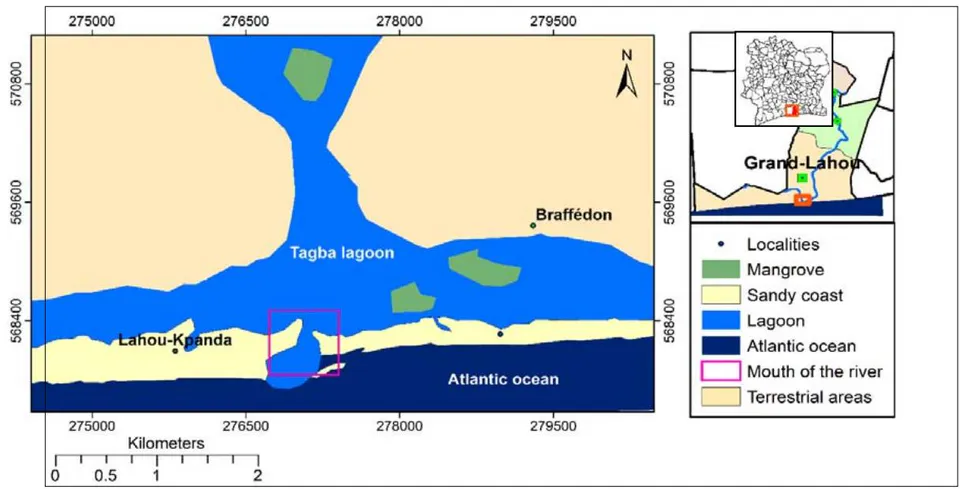
The study area includes part of the sandy coast of the city of Grand-Lahou, limited to the north by the Tagba lagoon, to the south by the Atlantic Ocean, to the east by the village of Braffédon and to the west by the village of Lahou-Kpanda (figure 1).
II. DATAS AND METHODOLOGY
a) Datas
As part of this study, several data were used, such as the USGS Earth Explorer site (https://earthexplorer.usgs.gov/) and Earthdata, which are Landsat 8 OLI TIRS, Landsat 7 ETM and ASTER DEM images. Indeed, LANDSAT images will make it possible to determine the evolution or change observed in a given area over time. As for the ASTER images (ASTER Global Digital Elevation Model 1 arc second), they are referenced in the geodetic coordinate system (WGS 84) on the 1996 Earth Gravitational Model (EGM 96) geoid and make it possible to observe the relief, the courses of in order to define the surface and depth volumes according to reference points. Theses datas will make it possible to assess the volumes of the right-of-way of the works. Other data comes from the Google Earth Pro application. These are aerial images acquired on January 17, 2020, downloaded from Google Earth Pro, seen at from the CNES Airbus sensor and constituting data elements recorded in the WGS 84 system. Seven images were recorded with a maximum resolution marked by twenty-eight (28) points including four (04) per image. The digital processing of the data and the cartographic layout were carried out using the ARCGIS 10 software.
b) Methodology
Techniques for inventorying the environment baseline of the project footprint
The inventory of the environment baseline consisted in the realization of the Land Cover and Land Use (LCLU) of the zone of study by the treatment and the classification of the spectral signature of satellite images. This classification was made by combining known indices such as Normalized Difference
Vegetation Index (NDVI), Normalized different Bare Index or Normalized Difference Built-up Index (NDBI) and Modified Normalized Difference Water Index (MNDWI). These respective indices will make it possible to highlight the three main classes of the OSUS, that is to say, vegetation, buildings, bare soil and water. The superposition of these three (03) classes will make it possible to describe the environment baseline.
Identification of the impacts of the works on the environment
The approach to identifying the impacts of the works on the environment was done by creating high-resolution images, taken from Google Earth Pro images of the work site. This approach was based on the pooling of several images recorded with high resolution by creating a single image per mosaic. This technique will highlight the entities or surfaces impacted by spatial interpolation.
III. RESULTS
a) Variation of the indices, NDVI, NDBI et MNDWI
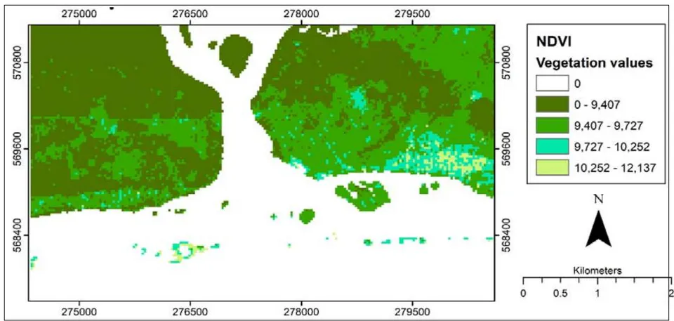
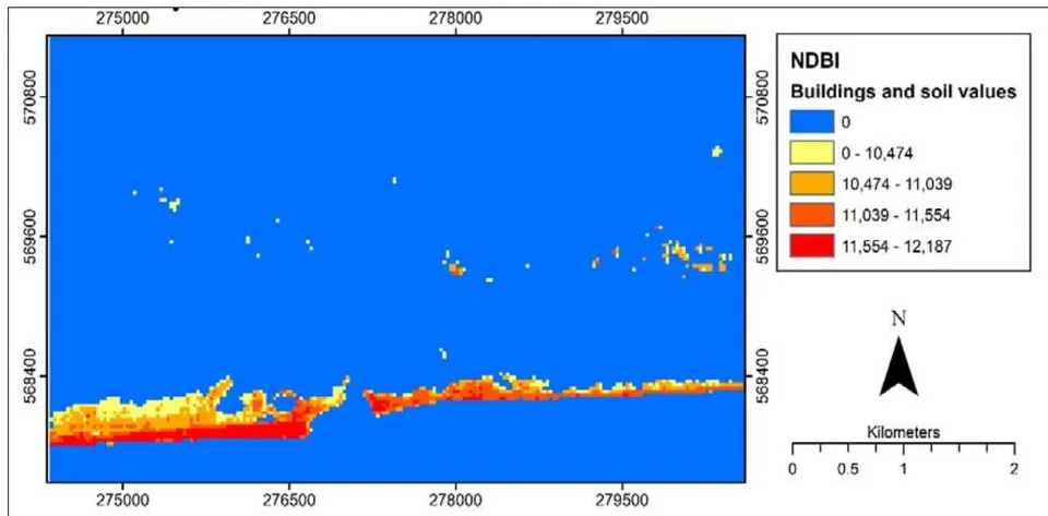
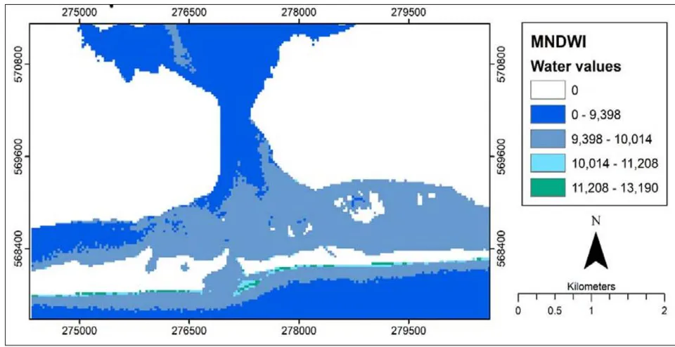
The calculation of NDVI makes it possible to present 3 types of vegetation corresponding to trees, shrubs and grasses. Values from 0 to 9,727 correspond to trees and those greater than 9,727 are shrubs and grasses. As for the NDBI, the value greater than 0.002 makes it possible to highlight the categories of built soils or built surfaces (value 0 to 11, 39) and bare soils (values greater than 11,39). Regarding MNDWI, it highlights 3 main classes of water, namely clear water (0 to 9,398), turbid water (greater than 9,398 to 10,014), visible sandy water (greater than 10,014). Figure 2 presents the variation of the indices.
b) Baseline of the Environment by Combination of Indices
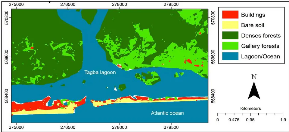
The combination of indices made it possible to observe 3 major classes of land use in the project area, including vegetation, sandy coast and water. The vegetation consists mainly of dense forests, gallery forests, forest islands and mangroves. The aquatic environment is made up of the Tagba lagoon, bordered by the Atlantic Ocean. As for the sandy coast that
separates the Atlantic Ocean from the Tagba lagoon, it includes buildings and bare soil (Figure 3).
c) Impacts of the Work to Open a New Pass on the Sandy Coast
i. Right-of-way
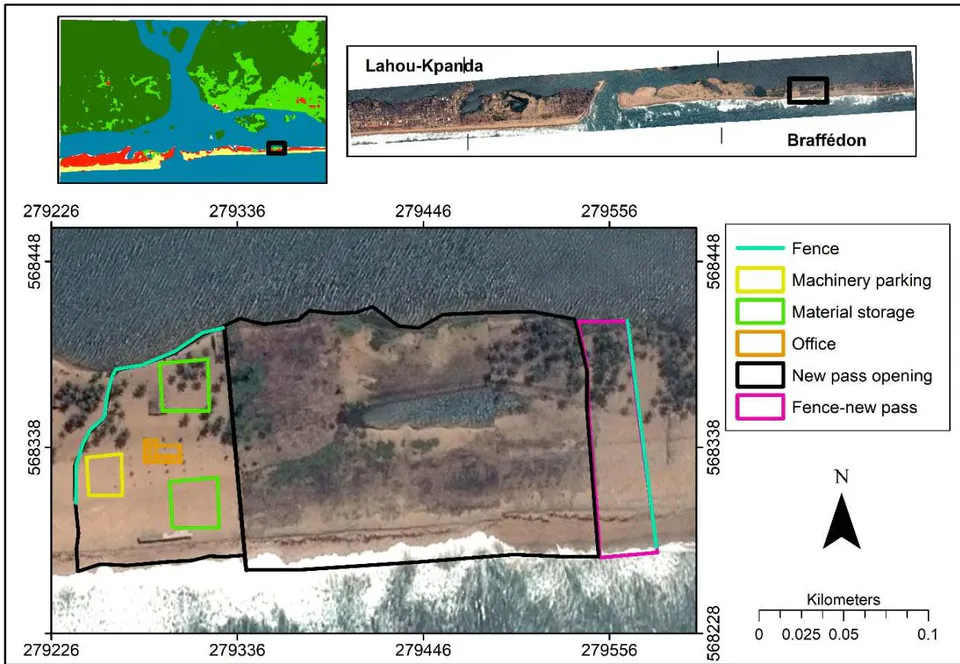
Work to open a new pass to the east of the sandy coast will be undertaken to facilitate natural exchanges between the Tagba lagoon and the Atlantic
Ocean. A site base with a total area of 45,502.18 m2 could be built, consisting of a site fence, parking areas for machinery, storage of materials, site offices, etc. Figure 4 shows the location and surface of the right-of-way for the opening of the new pass on the sandy coast.
ii. Impacts of works
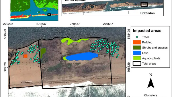
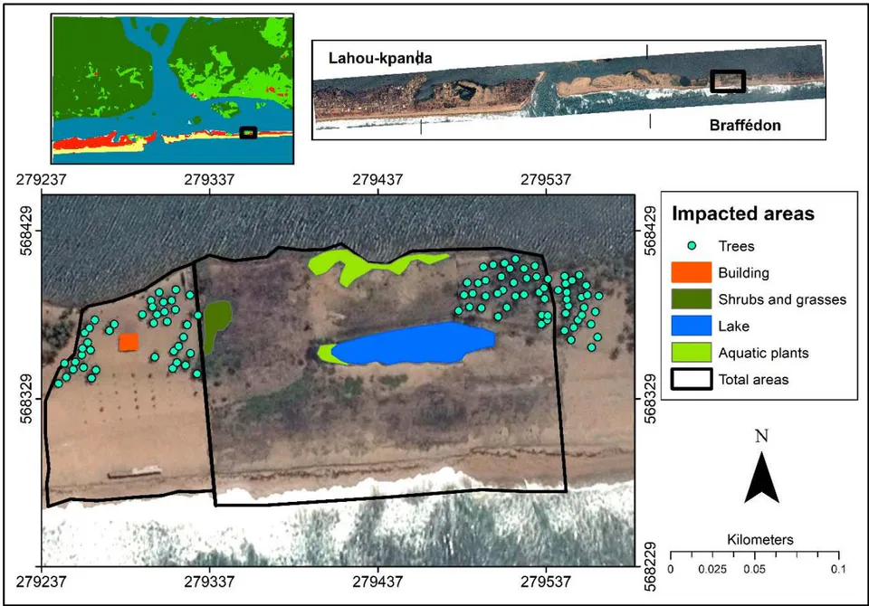
The opening of the new pass on the sandy coast is not without consequence on the biophysical environment, it will cause negative impacts there, in particular the destruction of 98 trees which could belong to the Palmaceae family, a building of a area of 97.14
, two surfaces of aquatic plants (one of and the other of ), a surface of shrubs and grasses of and a lake ecosystem of . Figure 5 shows the significance of the impacts of the work to open this new pass on the Grand-Lahou sandy coast.
IV. DISCUSSION
The realization of the Land Cover and Land Use by the interpolation of the indices NDVI, NDBI and MNDWI is a method which makes it possible to bring out the three main elements of the surface of the ground which are the vegetation, the materials (the buildings and the bare ground) and water. Indeed, NDVI is known for vegetation, NDBI for bare soil and infrastructure and MNDWI for water. These indices are used in mapping studies of urban areas and bare soils (KHALLEF et al, 2020). They can be used to study the evolution of Land Cover and Land Use (EL GAROUANI et al, 2021). The importance of the realization of the Land Cover and Land Use is part of the complexity of the study area, characterized by the mouth of the Bandama river, the lagoon complex, the sandy coast and the Atlantic Ocean, subject of several scientific works and publications for more than 50 years (BEDEVELOPMENT, 2017; DHI, 2015). On the basis of the existing data in the literature and collected, it appears that the stability of the mouth of the Bandama river is conditioned by the conjunction of the concomitant actions of the tidal currents (filling and emptying of the lagoon) and the flow of the river on the one hand, which keep the existing mouth open, and from the littoral drift generated by the swell on the other hand, which tends to close it. To do this, numerical and physical modeling studies were carried out to understand this complex dynamics, which made it possible to highlight the role of helical currents in the updrift migration (direction opposite to the coastal transit), from the ebb delta in the natural bypass of the transit on either side of the outlet and the influence of the position of the mouth of the Bandama river, along the sandy coast in the mechanism of its migration (LE DISSEZ et al., 2022). This therefore made it possible to carry out a phasing study of the opening of the new pass and the closing of the current one, a crucial point for the success of the work based on the numerical model studied.
V. CONCLUSION
This study is initiated to understand the approach to the environmental impact of coastal protection and preservation works carried out in complex estuarine areas. This approach made it possible to calculate, map the Land Cover and Land Use Indices in order to combine and interpolate them, with a view to identifying the biophysical impacts of coastal zone protection works. The use of high-resolution images from Google Pro's image mosaic helped to better appreciate the value of these impacts. Knowledge of these impacts should therefore enable the Contracting Authority to put in place compensation or adaptation measures for the populations affected by the works and to insert into the the contracts of the works companies, measures to reduce the impacts, in particular the planting of plant species to effectively combat coastal erosion and which plays an important role in carbon sequestration. Further studies could also bring out the mapping of the economic and social aspects of the project. These results could then constitute effective tools for the technical and environmental feasibility of resilience projects against the effects of climate change.